Downloaden Sie, um offline zu lesen


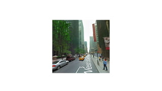


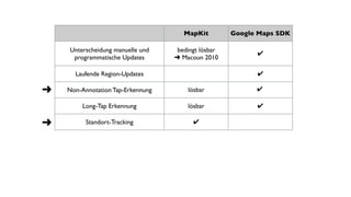


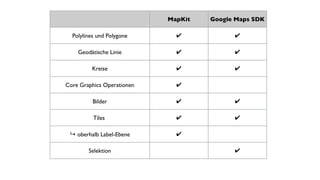
![MapKit Google Maps SDK
id<MKAnnotation> erstellen id<GMSMarker> erstellen
[mapView addAnnotation:] marker.map = mapView;
-[MKMapView:viewForAnnotation:]
implementieren
-(UIView*)mapView: markerInfoWindow:
[mapView removeAnnotation:] marker.map = nil;](https://image.slidesharecdn.com/macoun2014mapkitvsgooglemaps-141203030042-conversion-gate01/85/MapKit-vs-Google-Maps-SDK-Macoun-2014-19-320.jpg)

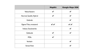
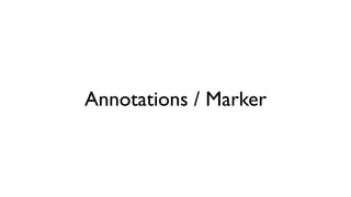
![MapKit Google Maps SDK
-(void)mapView:
didSelectAnnotationView:
-(BOOL)mapView:
didTapMarker:
-(void)mapView:
annotationView:
calloutAccessoryControlTapped:
-(void)mapView:
didTapInfoWindowOfMarker
-(void)mapView:
didDeSelectAnnotationView:
-(void)mapView:
didTapAtCoordinate:
-[MKAnnotationView
setSelected:animated:]](https://image.slidesharecdn.com/macoun2014mapkitvsgooglemaps-141203030042-conversion-gate01/85/MapKit-vs-Google-Maps-SDK-Macoun-2014-21-320.jpg)

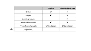
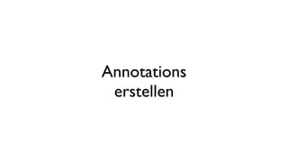
![MapKit Google Maps SDK
annotationView.draggable = YES; marker.draggable = YES;
-mapView:annotationView:
didChangeDragState:fromOldState:
-mapView:didBeginDraggingMarker:
-[MKAnnotationView
setDragState:animated:]
-mapView:didDragMarker:
-mapView:didEndDraggingMarker:](https://image.slidesharecdn.com/macoun2014mapkitvsgooglemaps-141203030042-conversion-gate01/85/MapKit-vs-Google-Maps-SDK-Macoun-2014-24-320.jpg)


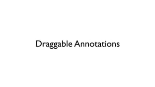
![MapKit Google Maps SDK
+[MKPolygon
polygonWithCoordinates:count:]
[[GMSPolygon alloc] init]
polygon.path
polygon.fillColor/strokeColor
-[MKMapView addOverlay:] polygon.map = mapView;
-mapView:rendererForOverlay:
MKPolygonRenderer.
fillColor/strokeColor
polygon.tappable = YES;
-(void)mapView:
didTapAtCoordinate:](https://image.slidesharecdn.com/macoun2014mapkitvsgooglemaps-141203030042-conversion-gate01/85/MapKit-vs-Google-Maps-SDK-Macoun-2014-28-320.jpg)


Das Dokument vergleicht Apple MapKit und Google Maps SDK hinsichtlich verschiedener Funktionen wie Kartenausschnitte, Animationen, Standort-Tracking und Annotationen. Beide Plattformen bieten vektorbasiertes Rendering, jedoch unterscheiden sie sich in der Benutzeroberfläche und der Bedienung. Zudem werden spezifische Implementierungsdetails und Herausforderungen bei der Nutzung beider Technologien erörtert.


