Rsq onepager w google play
•
0 gefällt mir•79 views

Road Surface Quality Data with your smartphone
Empfohlen

Empfohlen
Weitere ähnliche Inhalte
Was ist angesagt?
Was ist angesagt? (12)
Ähnlich wie Rsq onepager w google play
Ähnlich wie Rsq onepager w google play (20)
Mehr von Mike Maziarka
Mehr von Mike Maziarka (15)
Kürzlich hochgeladen
Kürzlich hochgeladen (20)
Rsq onepager w google play
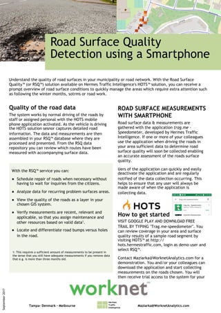
- 1. Road Surface Quality Detection using a Smartphone Quality of the road data The system works by normal driving of the roads by staff or assigned personal with the HOTS mobile phone application activated. As the vehicle is driving the HOTS solution sesnor captures detailed road information. The data and measurements are then assembled in your RSQ™ database where they are processed and presented. From the RSQ data repository you can review which routes have been measured with accompanying surface data. September2017 Understand the quality of road surfaces in your municipality or road network. With the Road Surface Quality™ (or RSQ™) solution available on Hermes Traffic Intelligence's HOTS™ solution, you can receive a prompt overview of road surface conditions to quickly manage the areas which require extra attention such as following the winter months, sotrms or road work. ROAD SURFACE MEASUREMENTS WITH SMARTPHONE Road surface data & measurements are gathered with the application trag.me - Speedometer, developed by Hermes Traffic Intelligence. If one or more of your colleagues use the application when driving the roads in your area sufficient data to determine road surface quality will soon be collected enabling an accurate assessment of the roads surface quality. Uers of the application can quickly and easily deactivate the application and are regularly notified of the data collection occurring. This helps to ensure that any user will always be made aware of when the application is collecting data. How to get started VISIT GOOGLE PLAY AND DOWNLOAD FREE TRAIL BY TYPING "Trag.me-speedometer". You can review coverage in your area and surface quality results of a sample road segment by visiting HOTS™ at http:// hots.hermestraffic.com, login as demo user and select RSQ™. Contact Maziarka@WorknetAnalytics.com for a demonstration. You and/or your colleagues can download the application and start collecting measurements on the roads chosen. You will then receive trial access to the system for your review. With the RSQ™ service you can: ● Schedule repair of roads when necessary without having to wait for inquiries from the citizens. ● Analyze data for recurring problem surfaces areas. ● View the quality of the roads as a layer in your chosen GIS system. ● Verify measurements are recent, relevant and applicable, so that you assign maintenance and other resources based on valid data1. ● Locate and differentiate road bumps versus holes in the road. 1: This requires a sufficient amount of measurements to be present in the sense that you still have adequate measurements if you remove data that e.g. is more than three months old. Tampa- Denmark – Melbourne Maziarka@WorknetAnalytics.com