

Empfohlen
Weitere ähnliche Inhalte
Was ist angesagt?
Was ist angesagt? (20)
Andere mochten auch
Andere mochten auch (19)
Ähnlich wie Dsc 12 surveying lab
Ähnlich wie Dsc 12 surveying lab (20)
Dsc 12 surveying lab
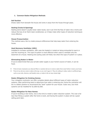
- 1. 1. Common Radon Mitigation Methods Soil Suction Draws radon from beneath the house and vents it away from the house through pipes. Sealing Cracks & Openings Sealing alone doesn't usually lower radon levels, but it can limit the flow of radon into a home and reduce the loss of air that's been conditioned, so it helps make other types of reduction techniques more effective. House Pressurization This method uses a fan to create pressure differences that help keep radon from entering the house. Heat Recovery Ventilator (HRV) Installed to increase ventilation, HRV uses the heated or cooled air being exhausted to warm or cool the incoming air. This type of system is most effective when used to ventilate only the basement of a house. Heating and cooling costs will likely rise when this type of system is in place. Eliminating Radon in Water If you've determined that your private water supply is your home's source of radon, it can be fixed. Point-of-entry treatments use charcoal filters or aeration devices to remove radon from water before it enters your home. Point-of-use devices remove radon at the tap, so you won't ingest it. They do nothing to reduce radon in unfiltered taps, such as your tubs, showers, and laundry areas, so radon in the air may remain high. Radon Mitigation for Existing Homes Your mitigation contractor can offer complete details about different types of radon reduction systems. After performing tests to determine how radon is entering your home the contractor will be in a better position to recommend the "best" system for your house. Costs vary, but most systems can be installed for $1,000-$2,500. Radon Mitigation for New Homes If you're building a new home, now is the time to install a radon reduction system. The cost is far less than fitting a system after the home is built, and having the system in place will be a good selling point later.
- 2. 2. A contour map has lines that show elevation. Any point on any line is at the same elevation. Let's say you have a map that includes a coastline and the lines are at 200 foot intervals. There would be lines at 200, 400, 600, 800, etc feet. You can see hills (the lines form circles), whether a slope is gradual or steep (where it's steep the lines are close together), and other features. Once you're used to one, it almost makes the map look 3-D. The distinctive characteristic of a topographic map is that the shape of the Earth's surface is shown by contour lines. Contours are imaginary lines that join points of equal elevation on the surface of the land above or below a reference surface such as mean sea level. Contours make it possible to measure the height of mountains, depths of the ocean bottom, and steepness of slopes. A topographic map shows more than contours. The map includes symbols that represent such features as streets, buildings, streams, and woods contour map will show the contours, or curves of the ground--i.e. elevation lines. They are helpful in letting you know you're on the right route. After figuring out your azimuth to get from point a to point b it's reassuring to know the maps says you're supposed to be walking up a hill and you actually are. You're in trouble if you look around and there's a ravine you have to cross but it's not where you thought you should be on the map. For pilots it lets them know just how high the ground is going to be so they can fly over and not into it. Same for boat pilots and the bottom of the body of water they're on. Topographic maps are frequently paired with handheld GPS devices, sports & fitness GPS devices, and smartphone applications. "Topo" maps provide highly detailed information about the natural and man-made aspects of the terrain, but are best known for their series of contour lines that show elevation changes, and colors signifying varying land types and bodies of water. Topographic maps in their paper form have been in use for many years, and are a mainstay of outdoorspeople and those who must understand landscape details for business purposes. Topographic maps are increasingly stored, transmitted, and used in digital format. For example, Garmin and DeLorme offer dozens of topo mapsets that may be purchased on DVD, SD card, or via direct download. Topographic maps come in different scales, and the differences are important. For example, the common "24K" topo map is in the scale of 1:24,000 (1 inch =
- 3. 2,000 feet) and shows great detail. The 24K map is also known as a "7.5 minute" map, because it covers 7.5 minutes of latitude and longitude. Another common format, the "100K" topo map, is in the scale of 1:100,000 (1 centimeter = 1 kilometer) and shows less detail, but covers a wider area than the 24K topo. Contour maps are very useful since they provide valuable information about the terrain. Some of the uses are as follows: i) The nature of the ground and its slope can be estimated ii) Earth work can be estimated for civil engineering projects like road works, railway, canals, dams etc. iii) It is possible to identify suitable site for any project from the contour map of the region. iv) Inter-visibility of points can be ascertained using contour maps. This is most useful for locating communication towers. v) Military uses contour maps for strategic planning. 3. System of tacheometry Depending on the type of instrument and methods/types of observations, tacheometric measurement systems can be divided into two basic types: (i) Stadia systems and (ii) Non-stadia systems Stadia systems: In this systems staff intercepts, at a pair of stadia hairs present at diaphragm, are considered. The stadia system consists of two methods: 1. Fixed-hair method: In this method, stadia hairs are kept at fixed interval and the staff interval or intercept (corresponding to the stadia hairs) on the leveling staff varies. Staff intercept depends upon the distance between the instrument station and the staff. 2. Movable-hair method: In this method, the staff interval is kept constant by changing the distance between the stadia hairs. Targets on the staff are fixed at a known interval and the stadia hairs are adjusted to bisect the upper target at the upper hair and the lower target at the lower hair. Instruments used in this method are required to have provision for the measurement of the variable interval between the stadia hairs. As it is inconvenient to measure the stadia interval accurately, the movable hair method is rarely used.
- 4. Non stadia systems: This method of surveying is primarily based on principles of trigonometry and thus telescopes without stadia diaphragm are used. This system comprises of two methods: (i) Tangential method In this method, readings at two different points on a staff are taken against the horizontal cross hair and corresponding vertical angles are noted. (ii) Subtense bar method. In this method, a bar of fixed length, called a subtense bar is placed in horizontal position. The angle subtended by two target points, corresponding to a fixed distance on the subtense bar, at the instrument station is measured. The horizontal distance between the subtense bar and the instrument is computed from the known distance between the targets and the measured horizontal angle.