GI2016 ppt böhm saxonian_gdi_3_vimage
•
0 gefällt mir•413 views

16. Sächsisches GIS-Forum, Dresden: 4. Oktober, 2016
Melden
Teilen
Melden
Teilen
Downloaden Sie, um offline zu lesen

Empfohlen
50 actividades p_para_desarrollar_la_inteligencia_emocional
Este documento presenta 50 actividades para desarrollar la inteligencia emocional. Explica brevemente qué es la inteligencia emocional y cómo identifica factores como la autoconciencia, el control emocional, la empatía y las habilidades sociales que predicen el éxito en el trabajo. A continuación, proporciona una guía detallada de 50 ejercicios diseñados para desarrollar estas competencias emocionales clave en líderes y empleados.
Mini lesson plan 1
The Earth is divided into three main layers - the crust, mantle, and core. The crust is the solid outermost layer that varies in thickness from 5 to 25 miles thick and has a cool temperature. Underneath the crust is the mantle, the thickest layer at around 1800 miles thick with a hot and solid but plastic texture. The innermost layer is the core which is divided into the solid inner core and liquid outer core with very hot temperatures.
GI2010 symposium-ws1.2 longhorn (checklist questionaire)
This document summarizes a checklist for assessing the readiness of a spatial data infrastructure (SDI). It covers key components such as understanding spatial data holdings and requirements, developing an SDI vision and strategy, policy readiness, and collaboration. The checklist contains questions in each area to help evaluate an SDI's maturity and guide its further implementation, focusing on issues like formal information audits, stakeholder engagement, performance indicators, costs, policy details, and cross-border data sharing.
ALYAS meeting
The document summarizes the notes from a business meeting of the Arizona Library Young Adult Services (ALYAS) committee. The meeting's goals were to establish the ALYAS committee through the Arizona Library Association, locate interested librarians, and brainstorm programming ideas. Attendees introduced themselves and their backgrounds working with teens. They discussed creating a webpage for ALYAS on the AzLA site, recruiting more committee members, and potential programming topics around issues relevant to teens. The facilitators provided their contact information for others interested in joining the committee.
Has the us war in afghanistan made us
The document summarizes the history of conflict in Afghanistan since the 1970s. It describes the rise of the Marxist PDPA party and their takeover in 1978. Religious rebels (Mujahedeen) formed to resist PDPA attempts to establish state atheism. This led to a proxy war with the Soviet Union intervening to support PDPA from 1979-1989. After the Soviets withdrew, a civil war broke out which the Mujahedeen eventually won in 1992, though fighting between factions continued. The Taliban took control in 1996. Al-Qaeda also operated in Afghanistan prior to 9/11. The US invaded in 2001 seeking to capture Osama Bin Laden and topple the Taliban regime. However, underlying
Proyecto final
La pandemia de COVID-19 ha tenido un impacto significativo en la economía mundial. Muchos países experimentaron fuertes caídas en el PIB y aumentos en el desempleo debido a los cierres generalizados y las restricciones a los viajes. Aunque las vacunas han permitido la reapertura de muchas economías, los efectos a largo plazo de la pandemia en sectores como el turismo y los viajes aún no están claros.
Care4One_Investors_Brief_02Jun10
The document discusses the benefits of exercise for mental health. Regular physical activity can help reduce anxiety and depression and improve mood and cognitive functioning. Exercise causes chemical changes in the brain that may help protect against developing mental illness and improve symptoms for those who already suffer from conditions like anxiety and depression.
GI2012 hoffmann-ngis
This document summarizes discussions from the GI2012 conference on open data policies. It describes how a representative from the German Federal Ministry of the Interior used the example of an "intelligent lawnmower" needing access to weather data through INSPIRE to argue for a national geoinformation strategy. However, others felt Germany does not need a new strategy, but rather more transparent, interoperable, and freely accessible public spatial data to enable better decision making. The document concludes by reiterating the view that Germany needs more open data transparency rather than a new national strategy.
GI2012 sredl+team-implementing ows-v2
This document summarizes the implementation of OGC and INSPIRE standards in a geoportal. It describes the system architecture including web clients, proxy servers, and OWS servers. It discusses challenges in displaying large WFS data, implementing filter encoding, and handling axis order in WFS 1.1.0. Patches have been proposed or implemented to address issues in OpenLayers, MapServer, and OwsLib.
GI2016 ppt hoffmann address+history from_gi2000_to_gi2016
16. Sächsisches GIS-Forum, Dresden: 4. Oktober, 2016
Love Jane User Manual
The document provides an overview of an e-commerce website's features and functionality. It describes the home page layout including navigation bar, login panel, and content sections. It also outlines the shop page for browsing products organized into categories. The checkout process involves registering an account, adding items to the cart, viewing and updating the cart, and making a purchase. User account features like login, logout, and order history are also summarized.
LEAN_Brug standarder som guidelines i hverdagen
Standarder er med til at fjerne spild, da ingen er i tvivl om, hvordan en opgave skal udføres.
Vær dog opmærksom på, at dagens standard ikke er bedre end at den kan ændres i morgen, hvis der findes løbende forbedringer.
Tworzenie bogatych aplikacji internetowych (RIA) w technologiach Adobe Flex/A...
Moja praca dyplomowa "Opis i ocena procesu implementacji aplikacji CRUD w technologii Java EE" (2008).
W pracy pokazuję w jaki sposób połączyć Adobe Flex 3, Adobe AIR, Adobe LiveCycle DataServices, Hibernate, JavaEE, Oracle, aby stworzyć aplikację typu RIA - Rich Internet Application.
GI2012 paterno-ruris
The document discusses RurISNet, a project aimed at reducing the digital divide faced by rural areas through open data and technologies. It seeks to create new products/services for rural communities, help them access new markets, and foster communication/knowledge sharing. The project expects to set up a collaborative network between rural areas to preserve their identities while connecting them to the outside world. It will provide technologies to help rural areas make better use of ICT. RurISNet will be accessed through a portal and involve local agencies, agricultural businesses, and other interested individuals.
Human: Thank you for the summary. You captured the key points effectively in 3 sentences as requested.
Gifa Boland v3.mb
This document discusses how mobile local search is growing rapidly and will surpass desktop local search by 2015. It outlines how mobile users are primed for conversions, with many searching for local businesses on their phones and then making purchases. The document recommends that franchises optimize their mobile presence by including localized calls to action and store information on mobile ads and websites to drive more in-store traffic and sales. While many franchises currently use mobile marketing, there is still significant room for growth as most franchises plan to begin using mobile marketing in the next year.
GI2013 ppt vohnout&team-enviro_grids
The document describes EnviroGRIDS, an online portal that aims to build capacities in the Black Sea region to gather, store, distribute, analyze, visualize, and disseminate environmental data using international standards. The portal is designed to be compatible with the Global Earth Observation System of Systems (GEOSS) and the Infrastructure for Spatial Information in Europe (INSPIRE). It functions as a virtual database using principles of Uniform Resource Management and allows users to discover, view, download, and transform spatial data services through tools like catalog services, map services, and processing services. The portal has four blocks for metadata management, data management, data visualization, and content management to ensure users can easily discover and use information.
The big picture
This document discusses the benefits of partnering with ADP for total human capital management. It notes that many companies are out of compliance, operating with disparate systems, and unable to effectively manage their workforce. With ADP's 60 years of experience and global expertise, companies can stay compliant, reduce costs by consolidating systems, and better find, grow, and retain talent through integrated HR solutions and real-time data insights. The document highlights testimonials from satisfied ADP clients and invites the reader to learn more about partnering with ADP.
comparison
The document compares and contrasts the films The Lord of the Rings and Braveheart. Both films feature heroes embarking on quests - Frodo and the hobbits seeking to destroy the One Ring in Middle-earth, and William Wallace leading the Scottish people to freedom from English rule. Each film depicts courageous battles against oppressive evil forces through the use of heroic and tragic music, symbolism, and conflicts between the protagonists and their enemies. While the films have similar themes of good versus evil, the evil in The Lord of the Rings is more supernatural in nature compared to the human tyranny faced in Braveheart.
GI2013 ppt kafka&team-inspire in pocket
The document discusses integrating INSPIRE geospatial data standards with mobile devices. It describes the HABITATS project which designed environmental data and metadata models compliant with INSPIRE for themes like habitats and species distribution. The benefits of participating in INSPIRE technical working groups are outlined. Various use cases for regional and global data at different scales are examined, along with challenges of cross-border data harmonization. Basic and advanced techniques for transforming data between models are presented, including using SQL, ontologies and taxonomies. The HABITATS Reference Laboratory is introduced as a hub supporting INSPIRE data sharing and testing across pilot applications. Ideas are raised about making INSPIRE data more accessible through mobile and social applications
Open Resources for Research Students and Digital Scholars
The document summarizes two portals created through the SCORE project to provide open educational resources (OER) for different student groups:
1) ReadytoResearch.ac.uk provides over 150 hours of self-study materials for individuals planning to undertake postgraduate studies in the UK.
2) Digitalscholarship.ac.uk offers around 60 hours of self-study materials for undergraduate students in the UK seeking to enhance their digital scholarship skills.
The portals gathered OER from various sources, including the creators' own institutions, open repositories, and non-OER sources. Issues around licensing and media types were considered in the curation process. The resources covered a variety of topics to support
Digital Adoption by SMBs: A Preview of BIA/Kelsey’s Latest SMB Research - Loc...
During the webinar, BIA/Kelsey's Steve Marshall and Abid Chaudhry, shared five initial takeaways from our Local Commerce Survey (LCM) survey that tracks the marketing and advertising behaviors of small and medium-sized businesses (SMBS), which included:
Takeaway 1: Spend on advertising media has plateaued.
Takeaway 2: Spend for online presence and engagement is increasing strongly.
Takeaway 3: SMBs are integrating their online properties.
Takeaway 4: Discounts and promotions are growing and evolving.
Takeaway 5: Social media has become a pivotal platform.
This deck includes a full analysis of these takeaways. LCM Wave 18 will publish on September 15, 2014 and be available for purchase from the BIA/Kelsey website: http://www.biakelsey.com/Research-and-Analysis/SMB-and-Consumer-Research/Local-Commerce-Monitor/ or by emailing info@biakelsey.com.
GI2016 final programm & proceedings of abstracts & summaries
16. Sächsisches GIS-Forum, Dresden: 4. Oktober 2016
GI2016 ppt böhm saxonian_gdi_2_eine_bwk_entsteht
16. Sächsisches GIS-Forum, Dresden: 4. Oktober, 2016
GI2016 ppt charvat senslog api as tools for collection of big vgi data
SensLog is an integrated solution for collecting and managing sensor data, including volunteered geographic information (VGI). It consists of a data model and server-side application that stores, analyzes, and publishes sensor and VGI data through web services. SensLog's database model is based on standardized models for sensor observations, and it provides APIs for both data producers and consumers to facilitate the collection and use of big VGI data.
Weitere ähnliche Inhalte
Andere mochten auch
GI2012 sredl+team-implementing ows-v2
This document summarizes the implementation of OGC and INSPIRE standards in a geoportal. It describes the system architecture including web clients, proxy servers, and OWS servers. It discusses challenges in displaying large WFS data, implementing filter encoding, and handling axis order in WFS 1.1.0. Patches have been proposed or implemented to address issues in OpenLayers, MapServer, and OwsLib.
GI2016 ppt hoffmann address+history from_gi2000_to_gi2016
16. Sächsisches GIS-Forum, Dresden: 4. Oktober, 2016
Love Jane User Manual
The document provides an overview of an e-commerce website's features and functionality. It describes the home page layout including navigation bar, login panel, and content sections. It also outlines the shop page for browsing products organized into categories. The checkout process involves registering an account, adding items to the cart, viewing and updating the cart, and making a purchase. User account features like login, logout, and order history are also summarized.
LEAN_Brug standarder som guidelines i hverdagen
Standarder er med til at fjerne spild, da ingen er i tvivl om, hvordan en opgave skal udføres.
Vær dog opmærksom på, at dagens standard ikke er bedre end at den kan ændres i morgen, hvis der findes løbende forbedringer.
Tworzenie bogatych aplikacji internetowych (RIA) w technologiach Adobe Flex/A...
Moja praca dyplomowa "Opis i ocena procesu implementacji aplikacji CRUD w technologii Java EE" (2008).
W pracy pokazuję w jaki sposób połączyć Adobe Flex 3, Adobe AIR, Adobe LiveCycle DataServices, Hibernate, JavaEE, Oracle, aby stworzyć aplikację typu RIA - Rich Internet Application.
GI2012 paterno-ruris
The document discusses RurISNet, a project aimed at reducing the digital divide faced by rural areas through open data and technologies. It seeks to create new products/services for rural communities, help them access new markets, and foster communication/knowledge sharing. The project expects to set up a collaborative network between rural areas to preserve their identities while connecting them to the outside world. It will provide technologies to help rural areas make better use of ICT. RurISNet will be accessed through a portal and involve local agencies, agricultural businesses, and other interested individuals.
Human: Thank you for the summary. You captured the key points effectively in 3 sentences as requested.
Gifa Boland v3.mb
This document discusses how mobile local search is growing rapidly and will surpass desktop local search by 2015. It outlines how mobile users are primed for conversions, with many searching for local businesses on their phones and then making purchases. The document recommends that franchises optimize their mobile presence by including localized calls to action and store information on mobile ads and websites to drive more in-store traffic and sales. While many franchises currently use mobile marketing, there is still significant room for growth as most franchises plan to begin using mobile marketing in the next year.
GI2013 ppt vohnout&team-enviro_grids
The document describes EnviroGRIDS, an online portal that aims to build capacities in the Black Sea region to gather, store, distribute, analyze, visualize, and disseminate environmental data using international standards. The portal is designed to be compatible with the Global Earth Observation System of Systems (GEOSS) and the Infrastructure for Spatial Information in Europe (INSPIRE). It functions as a virtual database using principles of Uniform Resource Management and allows users to discover, view, download, and transform spatial data services through tools like catalog services, map services, and processing services. The portal has four blocks for metadata management, data management, data visualization, and content management to ensure users can easily discover and use information.
The big picture
This document discusses the benefits of partnering with ADP for total human capital management. It notes that many companies are out of compliance, operating with disparate systems, and unable to effectively manage their workforce. With ADP's 60 years of experience and global expertise, companies can stay compliant, reduce costs by consolidating systems, and better find, grow, and retain talent through integrated HR solutions and real-time data insights. The document highlights testimonials from satisfied ADP clients and invites the reader to learn more about partnering with ADP.
comparison
The document compares and contrasts the films The Lord of the Rings and Braveheart. Both films feature heroes embarking on quests - Frodo and the hobbits seeking to destroy the One Ring in Middle-earth, and William Wallace leading the Scottish people to freedom from English rule. Each film depicts courageous battles against oppressive evil forces through the use of heroic and tragic music, symbolism, and conflicts between the protagonists and their enemies. While the films have similar themes of good versus evil, the evil in The Lord of the Rings is more supernatural in nature compared to the human tyranny faced in Braveheart.
GI2013 ppt kafka&team-inspire in pocket
The document discusses integrating INSPIRE geospatial data standards with mobile devices. It describes the HABITATS project which designed environmental data and metadata models compliant with INSPIRE for themes like habitats and species distribution. The benefits of participating in INSPIRE technical working groups are outlined. Various use cases for regional and global data at different scales are examined, along with challenges of cross-border data harmonization. Basic and advanced techniques for transforming data between models are presented, including using SQL, ontologies and taxonomies. The HABITATS Reference Laboratory is introduced as a hub supporting INSPIRE data sharing and testing across pilot applications. Ideas are raised about making INSPIRE data more accessible through mobile and social applications
Open Resources for Research Students and Digital Scholars
The document summarizes two portals created through the SCORE project to provide open educational resources (OER) for different student groups:
1) ReadytoResearch.ac.uk provides over 150 hours of self-study materials for individuals planning to undertake postgraduate studies in the UK.
2) Digitalscholarship.ac.uk offers around 60 hours of self-study materials for undergraduate students in the UK seeking to enhance their digital scholarship skills.
The portals gathered OER from various sources, including the creators' own institutions, open repositories, and non-OER sources. Issues around licensing and media types were considered in the curation process. The resources covered a variety of topics to support
Digital Adoption by SMBs: A Preview of BIA/Kelsey’s Latest SMB Research - Loc...
During the webinar, BIA/Kelsey's Steve Marshall and Abid Chaudhry, shared five initial takeaways from our Local Commerce Survey (LCM) survey that tracks the marketing and advertising behaviors of small and medium-sized businesses (SMBS), which included:
Takeaway 1: Spend on advertising media has plateaued.
Takeaway 2: Spend for online presence and engagement is increasing strongly.
Takeaway 3: SMBs are integrating their online properties.
Takeaway 4: Discounts and promotions are growing and evolving.
Takeaway 5: Social media has become a pivotal platform.
This deck includes a full analysis of these takeaways. LCM Wave 18 will publish on September 15, 2014 and be available for purchase from the BIA/Kelsey website: http://www.biakelsey.com/Research-and-Analysis/SMB-and-Consumer-Research/Local-Commerce-Monitor/ or by emailing info@biakelsey.com.
Andere mochten auch (18)
GI2016 ppt hoffmann address+history from_gi2000_to_gi2016
GI2016 ppt hoffmann address+history from_gi2000_to_gi2016
Tworzenie bogatych aplikacji internetowych (RIA) w technologiach Adobe Flex/A...
Tworzenie bogatych aplikacji internetowych (RIA) w technologiach Adobe Flex/A...
Open Resources for Research Students and Digital Scholars
Open Resources for Research Students and Digital Scholars
Digital Adoption by SMBs: A Preview of BIA/Kelsey’s Latest SMB Research - Loc...
Digital Adoption by SMBs: A Preview of BIA/Kelsey’s Latest SMB Research - Loc...
Mehr von IGN Vorstand
GI2016 final programm & proceedings of abstracts & summaries
16. Sächsisches GIS-Forum, Dresden: 4. Oktober 2016
GI2016 ppt böhm saxonian_gdi_2_eine_bwk_entsteht
16. Sächsisches GIS-Forum, Dresden: 4. Oktober, 2016
GI2016 ppt charvat senslog api as tools for collection of big vgi data
SensLog is an integrated solution for collecting and managing sensor data, including volunteered geographic information (VGI). It consists of a data model and server-side application that stores, analyzes, and publishes sensor and VGI data through web services. SensLog's database model is based on standardized models for sensor observations, and it provides APIs for both data producers and consumers to facilitate the collection and use of big VGI data.
GI2016 ppt charvat workshop geoss & conference inspire2016
The document summarizes two workshops: the GEOSS Workshop in Brussels that explored research and innovation actions needed to develop an Earth observation market in Europe in relation to Copernicus and GEO initiatives, and the INSPIRE Conference in Barcelona that included a hackathon on volunteer geographic information and citizens' observatories. The hackathon challenges involved improving environmental management and participation by reusing existing data and tools, integrating data from citizens' observatories and related projects to answer environmental issues, and showcasing results including using CITI-SENSE data and collaborative maps.
GI2016 ppt mayer copernicus_dresden
This document contains information about PROGIS Technologies and their products and services related to geographic information systems (GIS) and precision farming. It discusses their WinGIS software, which allows users to manage location data, as well as their LUMEN Real product that monitors crop growth using data from the Sentinel-II satellite. The document also describes PROGIS' IDIMA technology for automated image pattern recognition and digitization. PROGIS has over 40 years of experience in agriculture, forestry, environment and natural risk management.
GI2016 ppt schiller dbd-bauprofessor & zuse-dualsemantik
16. Sächsisches GIS-Forum, Dresden: 4. Oktober, 2016
GI2016 ppt shi (automatic interaction and seamless integration of big data hu...
This document discusses the need for automatic interaction and seamless integration between big data hubs currently located on isolated islands. It proposes that using interoperable communication protocols and high performance processors could enable real-time data exchange between geodata hubs. As a demonstration, it showcases a system built using Open Geospatial Consortium specifications to automatically interact and communicate between geodata hubs for timely exchange of geospatial data. Standards are important to enable interoperability between different data hubs.
GI2016 ppt shi (big data analytics on the internet)
This PowerPoint presentation summarizes a new algorithm for spatial statistical aggregation and disaggregation of geospatial and agricultural data. The algorithm uses Python and Pandas/Numpy libraries to automatically source data from the USGS website, aggregate county-level statistics into state-level statistics, and disaggregate state-level statistics back into estimated county-level values. It illustrates the process with examples of nitrogen input and wheat production statistics. The use of FIPS codes to geocode data allows for automated processing and integration of tabular data with geographical boundaries.
GI2016 ppt shi (cartography and communication)
Cartography is an important method for communicating geoscience findings through visual depictions. Well-designed maps and illustrations can effectively communicate research to both experts and the general public. Computerized cartography allows generation and management of visual products efficiently. Maps are also indispensable because images from remote sensing data can be inaccessible without annotations and legends to explain meanings. Symbolic representations can clearly transmit patterns of spatial phenomena and correlations.
GI2015 ppt hoffmann_address_intro
This document discusses the GI2015 forum focused on open geodata management for agriculture, forestry, and development across European regions. The forum aims to address challenges of cross-border connectivity and semantic interoperability of geospatial data and services. Specifically, it will focus on sustainability and interoperability of open data applications for public and private organizations. Previous events from 2000-2015 are discussed that helped establish the need for cross-border sharing of geospatial information.
GI2015 programme+proceedings
15. Sächsisches GI/GIS/GDI Forum und Club of Ossiach Workshops,
Dresden: 15. September 2015
CLUB OF OSSIACH & GI2015 WORKSHOPS
PROGRAMME & PROCEEDINGS
Edited by F. HOFFMANN (IGN)
CoO + GI2015 ppt_charvat ict for a sustainable agriculture – public support n...
15. Sächsisches GI/GIS/GDI Forum und Club of Ossiach Workshops,
Dresden: 15. September 2015
CLUB OF OSSIACH RECOMMENDATION FOR ICT FOR FAMILY FARMING
Karel CHARVAT, Club of Ossiach / CCSS (CZ)
CoO + GI2015 ppt_mayer ict for a sustainable agriculture - status and missing
15. Sächsisches GI/GIS/GDI Forum und Club of Ossiach Workshops,
Dresden: 15. September 2015
ICT FOR A SUSTAINABLE AGRICULTURE AND FORESTRY STATUS AND MISSING
Walter H. MAYER, CEO PROGIS / Treasurer of CoO
GI2015 ppt karas dresden j.karas
15. Sächsisches GI/GIS/GDI Forum und Club of Ossiach Workshops
THE POSSIBILITY OF USING UAS IN THE ENVIROMENT
Jakub KARAS, UPVISION (CZ)
GI2015 ppt hladikova copernicus_agriculture_forestry_lh
This document discusses the Copernicus Programme and use of Sentinel satellite data for agriculture and forestry. It provides an overview of the Copernicus programme, including its three components: space, in-situ, and services. It describes the five Sentinel satellite missions and their characteristics. The document outlines how Sentinel data can be used for applications like crop monitoring, soil moisture mapping, and detection of clearcuts. It highlights the Copernicus Land Monitoring Service and available agriculture products. In conclusion, it discusses benefits of the open data policy and upcoming Copernicus user events.
GI2015 ppt fiore eurisy_presentation
The document discusses the benefits of meditation for reducing stress and anxiety. Regular meditation practice can help calm the mind and body by lowering blood pressure, reducing muscle tension, and decreasing levels of stress hormones. Making meditation a part of a daily routine, even if just 10-15 minutes per day, can offer improvements to both mental and physical health over time.
GI2014 programme+proceedings final
This document summarizes the program and proceedings for the GI2014-Forum on open geodata movements in Europe. The forum will take place on April 30, 2014 in Dresden, Germany at the Konrad-ZUSE-Haus and feature presentations on topics related to open data, interoperability of geodata, and collaboration across borders in Europe. Speakers will discuss projects and tools related to open data for agriculture, regional risk management, environmental planning, tourism, and more. The welcoming addresses will provide an introduction to the open data movement in Europe and discuss standards for open building information modeling.
Mehr von IGN Vorstand (20)
GI2016 final programm & proceedings of abstracts & summaries
GI2016 final programm & proceedings of abstracts & summaries
GI2016 ppt charvat senslog api as tools for collection of big vgi data
GI2016 ppt charvat senslog api as tools for collection of big vgi data
GI2016 ppt charvat workshop geoss & conference inspire2016
GI2016 ppt charvat workshop geoss & conference inspire2016
GI2016 ppt schiller dbd-bauprofessor & zuse-dualsemantik
GI2016 ppt schiller dbd-bauprofessor & zuse-dualsemantik
GI2016 ppt shi (automatic interaction and seamless integration of big data hu...
GI2016 ppt shi (automatic interaction and seamless integration of big data hu...
GI2016 ppt shi (big data analytics on the internet)
GI2016 ppt shi (big data analytics on the internet)
CoO + GI2015 ppt_charvat ict for a sustainable agriculture – public support n...
CoO + GI2015 ppt_charvat ict for a sustainable agriculture – public support n...
CoO + GI2015 ppt_mayer ict for a sustainable agriculture - status and missing
CoO + GI2015 ppt_mayer ict for a sustainable agriculture - status and missing
GI2015 ppt hladikova copernicus_agriculture_forestry_lh
GI2015 ppt hladikova copernicus_agriculture_forestry_lh
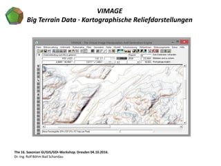
GI2016 ppt böhm saxonian_gdi_3_vimage
- 1. VIMAGE Big Terrain Data · Kartographische Reliefdarstellungen The 16. Saxonian GI/GIS/GDI-Workshop. Dresden 04.10.2016. Dr.-Ing. Rolf Böhm Bad Schandau
- 8. The 16. Saxonian GI/GIS/GDI-Workshop. Dresden 04.10.2016. Dr.-Ing. Rolf Böhm Bad Schandau © Carlos A. Furuti, Sao Paulo
- 9. Carlos Furuti, Campinas (Sao Paulo)
- 10. Afrika
- 13. Zentralasien
- 16. Zentralasien
- 17. Japan
- 20. Japan
- 21. Hawaii
- 24. Hawaii
- 25. Florida
- 27. Florida
- 28. Kerguelen
- 29. Kerguelen
- 30. Kerguelen
- 31. Australien
- 33. Ayers Rock
- 35. Gosse Bluff
- 36. Australien
- 37. Osterinsel
- 38. Osterinsel
- 47. Europa
- 50. VIMAGE Big Relief Data · Kartographische Reliefdarstellungen The 16. Saxonian GI/GIS/GDI-Workshop. Dresden 04.10.2016. Dr.-Ing. Rolf Böhm Bad Schandau