Geospatial tools to guide targeting of technologies
•Als PPTX, PDF herunterladen•
1 gefällt mir•85 views

Poster prepared by Francis Muthoni for the Africa RISING ESA Project Review and Planning Meeting, Lilongwe, Malawi, 3–5 October 2018.
Empfohlen

Empfohlen
Weitere ähnliche Inhalte
Was ist angesagt?
Was ist angesagt? (20)
Ähnlich wie Geospatial tools to guide targeting of technologies
Ähnlich wie Geospatial tools to guide targeting of technologies (20)
Mehr von africa-rising
Mehr von africa-rising (20)
Kürzlich hochgeladen
Kürzlich hochgeladen (20)
Geospatial tools to guide targeting of technologies
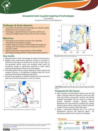
- 1. Geospatial tools to guide targeting of technologies Francis Muthoni International Institute of Tropical Agriculture Challenges & Study objective Sustainable intensification (SI) technologies are suited for specific biophysical & socio-economic context Knowledge on spatial distribution of optimal conditions for scaling technological options beyond the trial sites is lacking Objectives Generating recommendations domains for sustainable intensification technological packages Establish regional relevance of Africa RISING technologies by mapping zones with relatively similar biophysical and socio- economic context Spatial monitoring of implementation of Africa RISING technological packages (What is implemented where by who?) This poster is licensed for use under the Creative Commons Attribution 4.0 International Licence. September 2018 We thank farmers and local partners in Africa RISING sites for their contributions to this work. We also acknowledge the support of all donors which globally support the work of the CGIAR centers and their partners through their contributions to the CGIAR system Key results Mapped locations of AR- technologies for spatial monitoring (Fig i) Mapped zones experiencing significant increase or decrease in rainfall over ESA region (7 countries) for the last 37 years (Fig. ii). The generated rainfall trends and variability index useful for monitoring changes in agricultural potential to guide spatial targeting of appropriate climate smart technologies. Generated spatial indices to guide targeting of maize varieties and inorganic fertilizers i.e. Extrapolation suitability index (ESI; Fig iii) and Impact Based Spatial Targeting Index (IBSTI). Collated a geo-database of gridded biophysical & socio-economic data such as rainfall, temperature, access to markets Proposals for the future Map suitability of technological options over the ESA region using geo-reference agronomic data from field trials and remote sensing data. Partners will identify validated technologies that are ready for scaling and provide evidential variables showing optimal biophysical and socio-economic conditions for scaling. Spatial analysis will be conducted to identify potential suitable areas for scaling in wider ESA region. Design a web-based targeting tool to be used by development partners and extension agents for delineating suitable sites for specific technologies mm/yr-1 Fig ii. Spatial-temporal trends of annual rainfall (mm yr-1) over ESA countries. Blue ctones shows increasing trends while red tones shows increasing trend Fig33 3345567iii. Extrapolation suitability index (ESI) for SC719 maize variety and YaraMilla- Cereal and YaraBela-Sulfan fertilizers in Southern Tanzania. Suitability decreases with increasing ESI value Fig. i Spatial distribution of Africa RISING research and scaling sites in ESA region Partners