1. Product Guide
Digital Terrain Model
What is a Digital Terrain Model?
A Digital Terrain Model (DTM) is a digital file providing a highly detailed representation of the topographical
(i.e. relief) variations in the Earth’s surface. Combined with other digital data, such as maps or orthophotographs,
it can provide a 3D image of the land surface. Consisting of terrain elevations for ground positions at regularly
spaced horizontal intervals, the added dimension and visualisation offered by a DTM can help in many
decision-making processes.
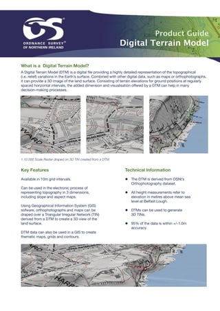
1:10 000 Scale Raster draped on 3D TIN created from a DTM
Key Features Technical Information
Available in 10m grid intervals. ◆ The DTM is derived from OSNI’s
Orthophotography dataset.
Can be used in the electronic process of
representing topography in 3 dimensions, ◆ All height measurements refer to
including slope and aspect maps. elevation in metres above mean sea
level at Belfast Lough.
Using Geographical Information System (GIS)
sofware, orthophotographs and maps can be ◆ DTMs can be used to generate
draped over a Triangular Irregular Network (TIN) 3D TINs.
derived from a DTM to create a 3D view of the
land surface. ◆ 95% of the data is within +/-1.0m
accuracy.
DTM data can also be used in a GIS to create
thematic maps, grids and contours.
2. Digital Terrain Model
Applications
◆ Planning
◆ Engineering
◆ Visualisation
◆ Height Analysis
X Co-Ordinate 337990
Y Co-Ordinate 405050
◆ Environmental Impact Analysis
Height 91.1868
◆ Sight Lines
◆ Wind flow and pollution dispersion
◆ Soil erosion modelling
◆ Flow direction and accumulation
DTM Data ◆ Watershed delineation
DTMs in Action
DTMs are used by a number of organisations and businesses
such as the construction industry, where they are used for
the creation of elevation models. Digital data, for example,
maps or photographs are draped over the elevation models to
provide a 3D view of the land surface. Architectural 3D models
can be added to the data to envisage future developments.
The resulting 3D models can then be used for planning and
environmental impact assessments.
OSNI in partnership with European Air Surveys created a 3D
‘fly through’ of the Mourne Mountains and Silent Valley.
By combining DTM with orthophotography the fly through
accurately represents land and height variations.
DTMs are also used for analytical applications. For example
telecommunication companies use a DTM for viewshed
analysis when planning sites of new masts. Insurance
companies also use a DTM to carry out floodplain analysis,
to identify areas at high and low risk of flooding, when setting
premiums.
Contact us
Ordnance Survey of Northern Ireland, Telephone 028 9025 5723
Colby House, Stranmillis Court, Email osni@osni.gov.uk
Malone Lower, Belfast, BT9 5BJ www.osni.gov.uk