Application of GIS and Remote Sensing in the analysis of Landuse/Landcover change study of Jharkhali Island, West Bengal ,Sundarbans.
•Als PPTX, PDF herunterladen•
4 gefällt mir•932 views

This document summarizes a study that analyzed land use and land cover changes on Jharkhali Island in the Sundarbans region of West Bengal, India between 1990 and 2010 using remote sensing and GIS techniques. The objectives were to classify land cover, determine changes in vegetation cover, and evaluate the socioeconomic implications. Supervised classification and change detection methods revealed accretion of new land, a shift to more anthropogenic land uses, and ongoing pressure on the local ecology from population growth. Similar changes were found to be occurring elsewhere in the Sundarbans region.

Empfohlen
Empfohlen
Weitere ähnliche Inhalte
Was ist angesagt?
Was ist angesagt? (20)
Andere mochten auch
Andere mochten auch (20)
Ähnlich wie Application of GIS and Remote Sensing in the analysis of Landuse/Landcover change study of Jharkhali Island, West Bengal ,Sundarbans.
Ähnlich wie Application of GIS and Remote Sensing in the analysis of Landuse/Landcover change study of Jharkhali Island, West Bengal ,Sundarbans. (20)
Kürzlich hochgeladen
Kürzlich hochgeladen (20)
Application of GIS and Remote Sensing in the analysis of Landuse/Landcover change study of Jharkhali Island, West Bengal ,Sundarbans.
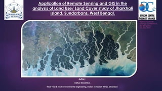
- 1. Application of Remote Sensing and GIS in the analysis of Land Use/ Land Cover study of Jharkhali Island, Sundarbans, West Bengal. Author : Aditya Shreshtkar, Final Year B.Tech Environmental Engineering, Indian School Of Mines, Dhanbad National Climate Change Conference, IISc Bengaluru 2-3 July, 2015
- 2. Introduction • Land use and land cover change has become a central component in current strategies for managing natural resources and monitoring environmental changes. • Population Explosion in the Sundarban regions have cost drastic change in Land Use/ Land Cover patterns. • Study Area is a World Heritage Site (UNESCO, 1989), contains substantial part of Namakhana R.F. and have few Ramsar Sites. • Use of technologies like Remote Sensing and GIS comes very handy in study of such large spatial areas and phenomenons. KEYWORDS : Sundarbans Remote Sensing & GIS Landuse Change Population Pressure Study Area Objectives • To create a land cover classification scheme and determine the land use & land cover changes. • To analyse the change in the vegetation cover. • To generate data on land consumption and land absorption coefficient • To evaluate the socio-economic implication of the change. Methodology • Time Series Analysis of LULC for two epochs : 1990 and 2010 • Maximum Likelihood Supervised Classification • Preparation of Vegetation Maps using NDVI • Change Detection using Image Differencing, DNDVI and Overlay Operations. Results and Implications • The landuse change dynamics of Jharkhali island indicate prolonged anthropogenic pressure on a fragile ecological niche of the Sundarbans. • Accretion of Land • Shift in economic practices. • There are other areas in Gosaba and Hingalganj where similar changes have taken place in recent times.