🔥HOT🔥📲9602870969🔥Prostitute Service in Udaipur Call Girls in City Palace Lake...
The atlantic road norway’s construction of the century
1. TweetTweet 93
The Atlantic Road: Norway’s Construction of
the Century
Categories: BEST OF, DESIGN, TRAVEL Tags: · norway · Leave a Comment
1
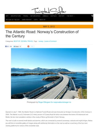
Photograph by Roger Ellingsen for nasjonaleturistveger.no
Opened on July 7, 1989, the Atlantic Road is a National Tourist Route and was honoured as Norway’s Construction of the Century in
2005. The Atlantic is an 8.3 kilometer (5.2 miles) section of Country Road 64 which runs between the towns of Kristiansund and
Molde, the two main population centres in the county of More og Romsdal in Fjord, Norway.
The road is built on several small islands and skerries, which are connected by several causeways, viaducts and eight bridges. Below
you will find an incredible gallery of images along with additional information on the road as well as a summary of the four main
viewing platforms for visitors of this incredible route.
MAY 5, 2012
Like 696
ART ARCHITECTURE TRAVEL NATURE/SPACE ANIMALS SCI/TECH HISTORY THE REST
PICTURE OF THE DAY SHIRK REPORT LISTS BEST OF
3. Photograph by Georgio Ghezzi
The Atlantic Road, Norway
- The Atlantic Road zigzags across low bridges that jut out over the sea, linking the islands between Molde (famous for its annual jazz
festival in July) and Kristiansund in the western fjords
- The route was originally proposed as a railway line in the early 20th century, but this was ultimately abandoned. Serious planning of
the road started in the 1970s, and construction started on 1 August 1983
- During construction, the area was hit by twelve hurricanes. The road was opened on 7 July 1989, having cost 122 million Norwegian
krone (NOK), of which 25 percent was financed with tolls and the rest from public grants
- Collection of tolls was scheduled to run for 15 years, but by June 1999 the road was paid off and the toll removed. The road is
preserved as a cultural heritage site and is classified as a National Tourist Route
- It is a popular site to film automotive commercials, has been declared the world’s best road trip, and been awarded the title as
“Norway’s Construction of the Century”
- In 2009, the Atlantic Ocean Tunnel opened from Averøy to Kristiansund; combined, they have become a second fixed link between
Kristiansund and Molde
[Source: Wikipedia, Visit Norway]
5. Photograph by Vincenzo Manzoni
The Atlantic Road Viewing Platforms
Photograph by Vegar Moen for nasjonaleturistveger.no
6. Photograph by Jiri Havran for nasjonaleturistveger.no
Photograph by Per Kollstad for nasjonaleturistveger.no
7. ASKEVAGEN
Along Atlanterhavsvegen, several smaller roads branch out to ports with breakwaters offering protection from the elements. Out on the
breakwaters, the sense of closeness to the ocean and the forces of nature is at its most intense, in stormy as well as sunny weather.
The viewing platform on the outer end of the breakwater at Askevagen offers a 360-degree panoramic view of the archipelago, the
ocean and the shore.
Architect: 3 RW – Jacob Rossvik. Landscape architect: Smedsvig. [Source]
Photograph by Roger Ellingsen for nasjonaleturistveger.no
8. Photograph by Jiri Havran for nasjonaleturistveger.no
Photograph by Per Kollstad for nasjonaleturistveger.no
KJEKSA
Rest area with a trail and a viewing platform. From the rest area, a magnificent view unfolds to the shipping lane and the wide ocean.
A trail leads down to the water’s edge.
Architect: 3 RW – Jacob Rossvik. Landscape architect: Smedsvig. [Source]
9. Photograph by Jarle Waehler for nasjonaleturistveger.no
Photograph by Roger Ellingsen for nasjonaleturistveger.no
GEITOYA
On Geitoya island, the terrain offers plenty of opportunities for taking picturesque photos of the ensemble of bridges and the
archipelago. From here, a boat service runs to the well-known fishing village of Håholmen. A trail leads to a viewing platform under the
Geitøya bridge, often used by anglers.
Landscape architects: Smedsvig Landskapsarkitekter. [Source]
10. Photograph by Roger Ellingsen for nasjonaleturistveger.no
Photograph by Roger Ellingsen for nasjonaleturistveger.no
11. Photograph by Roger Ellingsen for nasjonaleturistveger.no
MYRBAERHOLMBRUA
On specially constructed fishing bridges running along each side of the Myrbærholm bridge you can safely try your hand as an angler.
In the strong tidal flow under the bridges there are good chances that a coalfish, pollock, cod or mackerel may bite.
Architect: Manthey Kula, Beate Hølmebakk. [Source]
13. Photograph by Roger Ellingsen for nasjonaleturistveger.no
Photograph by Cricket Ltd. on Flickr
14. Photograph by Stewart Atkins
Photograph by Niels Breve
Sources
- Visit Norway: The Atlantic Road
- Nasjonale Turistveger: Atlanterhavsvegen
- Atlantic Ocean Road on Wikipedia
If you enjoyed this post, the Sifter highly recommends:
The Craziest Cliffs in Norway
15. «Previous
Picture of the Day: Stairway to Contrast »Next
Picture of the Day: A Tunnel Made of Ivy
TweetTweet 1
Comments
696
Like
Search
16. Enter email... Subscribe
TwistedSifter
Like
195,427 people like Tw istedSifter.
Facebook social plugin
Popular Posts
50 Life Hacks to Simplify your World
The 50 Most Perfectly Timed Photos Ever
50 Animated Gifs for Every Situation Ever
Portraits of People with Everything they Own
The Top 100 'Pictures of the Day' for 2012
The Top 50 'Pictures of the Day' for 2012
The Coolest Things Chris Hadfield Taught Us About Space
ABOUT PRIVACY POLICY
SUBMIT CONTACT
17. 21 Roads You Have to Drive in Your Lifetime
Picture of the Day: Chicago from Afar
This is What Happens When You Photoshop Celebrities Into Your Holiday Party
Enter email... Subscribe
Popular Tags
3D abandoned aerialairplanes awww beaches birds black and white blending boats cityscape close up clouds competition conceptual
crafts facts food gardens hobbies house illustration japan landscapes largest macro miniature mountains NASA new york night time
opulence painting perfect timing phenomena photo series portraits sculpturestreet art trees united
states vehicles vintage water world record