SlideShare ist ein Scribd-Unternehmen logo
1 von 12
HOW WILL YOU FIND OUT A NH47 ROUTE MAP
IN TAMILNADU
NATIONAL HIGHWAY 47 (INDIA)
Route information
Length: 620 km (390 mi)
Major junctions
North end: Salem, Tamil Nadu
Coimbatore (NH 67),
Coimbatore (NH 209),
Palakkad (NH 213),
Edapally (NH 17),
Kundannoor (NH 49),
Kundannoor (NH 47A),
Kollam (NH 220),
Kollam (NH 208),
Nagarcoil (NH 47B)
South end: Kanyakumari, Tamil Nadu
Location
States: Kerala: 416 km (258 mi)
Tamil Nadu: 224 km (139 mi)
Primary
destinations:
Salem - Coimbatore -
Palakkad -Thrissur - Kochi -
Alappuzha -
Kollam,Thiruvananthapuram -
Nagercoil -Kanyakumari
Highway system
Indian Road Network
National
Expressways
State
← NH 46 NH 47A →
National Highway 47, commonly referred to as NH 47, is a 620 km
(390 mi) long highway connecting the city of Salem toKanyakumari town in
southern India.

The important towns connected
are Salem, Coimbatore, Palakkad, Thrissur, Kochi,Alappuzha, Kollam, Thir
uvananthapuram, Nagercoil and Kanyakumari.[1]
 The NH 47 runs within a few kilometers ofCoimbatore International
Airport (within Coimbatore city limits), Cochin International Airport
(Nedumbassery) and theThiruvananthapuram (Trivandrum) International
Airport.
 The Salem-Coimbatore-Kochi stretch of the highway is included in
the North-South Corridor of the Indian highway system. It is currently
undergoing conversion to 4 lane, with some sections 6 lane.[2][3]
At the end
of 2010, 40% of this stretch is 4 laned, and 35% under implementation
TRAFFIC
The stretch between the Industrial city of Coimbatore and the Port
city of Kochi is one of the busiest in the Indian Highway system.
Most of the traffic in this stretch comprises trucks carrying consumer goods,
construction materials, container lorries (bound for Kochi Port and Kochi
International Container Transhipment Terminal) and passenger vehicles.
During night, the highway experiences a huge volume of traffic. On an
average, around 8,000 lorries use this highway to reach Coimbatore every
night. The highway has several motels and restaurants along the entire
stretch.
Fatal accidents frequently happen in this highway, mostly due to
irresponsible bus drivers and over-speeding lorries colliding head on. Many
number of Large Industries and Textile parks are located on this
highway between Coimbatore, Erode and Tiruppur districts.
Earlier the National Highway-47 which used to pass through the centre of
Coimbatore city, now completely bypasses the city, with the commissioning
of L&T by-pass road.
The arterial Avinashi Road and Palakkad Road in Coimbatore city's stretch
from Neelambur to Madukkarai through Ukkadam, Karumbukadai,
Attuppalam, Kuniyamuthur has now been transferred to the State Highways
Department, and is not part of the NH 47 anymore.
In case of any mishaps on the highway, the emergency services are
sometimes delayed several hours due to the volume of traffic in
the Coimbatore-Salem Industrial Corridor
ROUTE
Salem, Sankari, Komarapalayam, Bhavani, Chithode (ErodeByepass),Nasiyanur, P
erundurai, Vijayamangalam, Chengapalli,Perumanallur(bypass), New
Tirupur(Netaji Apparel Park), Avinashi(bypass),
Tekkalur, Karumathampatti, Kaniyur, Neelambur (Coimbatore
bypass), Madukkarai (Coimbatore Bypass), K.G.Chavadi(bypass), Walayar(Tamil
Nadu-Kerala Border),Kanjikode, Chandranagar (Palakkad
Bypass), Alathur, Vadakkanchery, Mannuthy (ThrissurBypass), Chalakkudy, Anga
maly,Aluva, Kalamassery, Edapally (KochiBypass), Vytilla (KochiBypass), Aroor,
Vayalar, Cherthala, Alappuzha, Kalarcode,Punnapra, Ambalappuzha, Haripad, Ka
yamkulam, Oachira, Karunagappally, Kollam, Kottiyam, Mylakkadu, Chathannoor
, Paripalli, Kallambalam, Attingal,Kazhakkuttam(ThiruvananthapuramBypass), Ko
valam, Nemom, Balaramapuram, Neyyattinkara, Parassala, (Kerala-TamilNadu
Border), Kaliyakkavilai, Kuzhithurai,Marthandam,Azhagiamandapam Thuckalay,
Parvathipuram, Nagercoil, Kottar, Suchindram and Kanyakumari.[4]
STATUS
Though the Government of India is investing in widening the National
Highways, NH 47 is predominantly a two-lane highway for many parts of
south Kerala.
The stretch from Mannuthy (in Thrissur District)
to Cherthala (in Alappuzha District) is almost completely four-laned along
the Bypass to Cochin city. However, the junction at Edappally with NH-
17 which runs to Panvel(Navi Mumbai)
via Kozhikode, Kannur, Mangalore, Goa) is a very congested junction.
The widening of Chengapalli-Walayarstretch of North-South corridor is in
process,Of this, the first stretch from Chengapalli to Nillambur in
Coimbatore (42.705 km), where it would touch the already widened
Coimbatore bypass, would facilitate six-lane traffic while the 12 km segment
from Madukkarai(Coimbatore) to Walayar would be four-lane.
Six laning from Chengapalli starts from Coimbatore Bypass section of NH-
47 and Four lane from Madukkarai on end of Coimbatore Bypass to Tamil
Nadu/Kerala Border up to Walayar section of NH-47 in the State of Tamil
Nadu.
ROAD IMPROVEMENT
Nearly 400 km (250 mi) of NH 47 between Cherthala and Salem passing
through Kochi, Thrissur, Palakkad and Coimbatore is under various stages
of expansion into express highway.
The stretch from Thrissur to Cherthala passing through Kochi city has been
widened to multiple lanes with six-lanes in many stretches.
The road widening has started at the Salem End of the Highway and the 4
lane work has been completed in the Salem-Chengapalli (Km 0 to 100)
stretch and there is a new bridge built on the Cauvery river at Bhavani
Kooduthurai.
Widening to six lanes is in progress between Perumanallur and Coimbatore
city. Also, widening is in progress from Thrissur to Walayar (Kerala- Tamil
Nadu Border, Palakkad District, Kerala).
Of this, the stretch from Mannuthy to Vadakkanchery in Palakkad
District(30 km) would facilitate six-lane traffic while the 58 km segment
from Vadakkanchery to Walayar near Coimbatore would be four-lane
expressway.
However,delays in land acquisition has put on hold the widening of NH 47
from Cherthala to Kanyakumari through Kollam and Thiruvananthapuram.
We can find the NH47 routemap in TamilNadu we can use GPSinIndia.com -
the largest repository of Global Positioning System (GPS) knowledge in India.
Global Positioning System (GPS)
The Global Positioning System (GPS) is a space-based satellite
navigation system that provides location and time information in all weather
conditions, anywhere on or near the Earth where there is an unobstructed
line of sight to four or more GPS satellites.
The system provides critical capabilities to military, civil and commercial
users around the world. It is maintained by the United States government
and is freely accessible to anyone with a GPS receiver.
The GPS project was developed in 1973 to overcome the limitations of
previous navigation systems,[1]
integrating ideas from several predecessors,
including a number of classified engineering design studies from the 1960s.
GPS was created and realized by the U.S. Department of Defense (DoD) and
was originally run with 24 satellites. It became fully operational in
1994. Bradford Parkinson, Roger L. Easton, and Ivan A. Getting are credited
for inventing it.
Advances in technology and new demands on the existing system have now
led to efforts to modernize the GPS system and implement the next
generation of GPS III satellites and Next Generation Operational Control
System (OCX).[2]
Announcements from the Vice President and the White House in 1998
initiated these changes. In 2000, U.S. Congress authorized the modernization
effort, GPS III.
In addition to GPS, other systems are in use or under development. The
Russian Global Navigation Satellite System (GLONASS) was developed
contemporaneously with GPS, but suffered from incomplete coverage of the
globe until the mid-2000s.
There are also the planned European Union Galileo positioning system,
Chinese Compass navigation system, and Indian Regional Navigational
Satellite System.
GPS Functionality
GPS systems are made up of 3 segments
Space Segment (SS)
Control Segment (CS)
User Segment (US)
Space Segment
 GPS satellites fly in circular orbits at an altitude of 20,200 km and with a
period of 12 hours.
 Powered by solar cells, the satellites continuously orient themselves to point
their solar panels toward the sun and their antenna toward the earth.
 Orbital planes are centered on the Earth
 Each planes has about 55° tilt relative to Earth's equator in order to cover the
polar regions.
 Each satellite makes two complete orbits each sidereal day.
 Sidereal - Time it takes for the Earth to turn 360 degrees in its
rotation
 It passes over the same location on Earth once each day.
 Orbits are designed so that at the very least, six satellites are always within
line of sight from any location on the planet.
 There are currently 30 actively broadcasting satellites in the GPS
constellation.
 Redundancy is used by the additional satellites to improve the precision of
GPS receiver calculations.
 A non-uniform arrangement improves the reliability and availability of the
system over that of a uniform system, when multiple satellites fail
 This is possible due to the number of satellites in the air today
Control Segment
 The CS consists of 3 entities:
 Master Control System
 Monitor Stations
 Ground Antennas
Master Control Station
 The master control station, located at Falcon Air Force Base in Colorado
Springs, Colorado, is responsible for overall management of the remote
monitoring and transmission sites.
 GPS ephemeris is the tabulation of computed positions, velocities and
derived right ascension and declination of GPS satellites at specific times for
eventual upload to GPS satellites.
Monitor Stations
 Six monitor stations are located at Falcon Air Force Base in Colorado, Cape
Canaveral, Florida, Hawaii, Ascension Island in the Atlantic Ocean, Diego
Garcia Atoll in the Indian Ocean, and Kwajalein Island in the South Pacific
Ocean.
 Each of the monitor stations checks the exact altitude, position, speed, and
overall health of the orbiting satellites.
 The control segment uses measurements collected by the monitor stations to
predict the behavior of each satellite's orbit and clock.
 The prediction data is up-linked, or transmitted, to the satellites for
transmission back to the users.
 The control segment also ensures that the GPS satellite orbits and clocks
remain within acceptable limits. A station can track up to 11 satellites at a
time.
 This "check-up" is performed twice a day, by each station, as the satellites
complete their journeys around the earth.
 Variations such as those caused by the gravity of the moon, sun and the
pressure of solar radiation, are passed along to the master control station.
Ground Antennas
 Ground antennas monitor and track the satellites from horizon to horizon.
 They also transmit correction information to individual satellites.
User Segment
 The user's GPS receiver is the US of the GPS system.
 GPS receivers are generally composed of an antenna, tuned to the
frequencies transmitted by the satellites, receiver-processors, and a highly-
stable clock, commonly a crystal oscillator).
 They can also include a display for showing location and speed information
to the user.
 A receiver is often described by its number of channels this signifies how
many satellites it can monitor simultaneously. As of recent, receivers
usually have between twelve and twenty channels.
 Using the RTCM SC-104 format, GPS receivers may include an input for
differential corrections.
 This is typically in the form of a RS-232 port at 4,800 bps speed. Data is
actually sent at a much lower rate, which limits the accuracy of the signal
sent using RTCM.
 Receivers with internal DGPS receivers are able to outclass those using
external RTCM data
Position Calculation
 The coordinates are calculated according to the World Geodetic System
WGS84 coordinate system.
 The satellites are equipped with atomic clocks
 Receiver uses an internal crystal oscillator-based clock that is continually
updated using the signals from the satellites.
 Receiver identifies each satellite's signal by its distinct C/A code pattern,
then measures the time delay for each satellite.
 The receiver emits an identical C/A sequence using the same seed number
the satellite used.
 By aligning the two sequences, the receiver can measure the delay and
calculate the distance to the satellite, called the pseudorange.
 Orbital position data from the Navigation Message is used to calculate the
satellite's precise position. Knowing the position and the distance of a
satellite indicates that the receiver is located somewhere on the surface of an
imaginary sphere centered on that satellite and whose radius is the distance
to it.
 When four satellites are measured at the same time, the point where the four
imaginary spheres meet is recorded as the location of the receiver.
 Earth-based users can substitute the sphere of the planet for one satellite by
using their altitude. Often, these spheres will overlap slightly instead of
meeting at one point, so the receiver will yield a mathematically most-
probable position.
Issues That Affect Accuracy
 Changing atmospheric conditions change the speed of the GPS signals
as they pass through the Earth's atmosphere and ionosphere.
 Effect is minimized when the satellite is directly overhead
 Becomes greater for satellites nearer the horizon, since the signal is
affected for a longer time.
 Once the receiver's approximate location is known, a mathematical
model can be used to estimate and compensate for these errors.
 Clock Errors can occur when, for example, a GPS satellite is boosted
back into a proper orbit.
 The receiver's calculation of the satellite's position will be incorrect
until it receives another ephemeris update.
 Onboard clocks are accurate, but they suffer from partial clock drift.
 GPS Jamming can be used to limit the effectiveness of the GPS signal
 For example, it is believed GPS guided missles have been misled to
attack non-target locations in the war in Afghanistan.
 The stronger the jamming signal, the more interference can be caused
to the GPS signal.
 GPS signals can also be affected by multipath issues
 Radio signals reflect off surrounding objects at a location. These
delayed signals can cause inaccuracy.
 Less severe in moving vehicles. When the GPS antenna is moving, the
false solutions using reflected signals quickly fail to converge and
only the direct signals result in stable solutions.
Methods of Improving Accuracy
 Precision monitoring
 Dual Frequency Monitoring
 Refers to systems that can compare two or more signals
 These two frequencies are affected in two different ways. How
they are affected can be predicted however
 After monitoring these signals, it’s possible to calculate what
the error is and eliminate it
 Receivers that have the correct decryption key can decode the
P(Y)-code transmitted on signals to measure the error.
 Carrier-Phase Enhancement (CPGPS)
 CPGPS uses the L1 carrier wave, which has a period 1000
times smaller than that of the C/A bit period, to act as an
additional clock signal and resolve uncertainty.
 The phase difference error in the normal GPS amounts to
between 2 and 3 meters (6 to 10 ft) of ambiguity.
 CPGPS works to within 1% of perfect transition to reduce the
error to 3 centimeters (1 inch) of ambiguity.
 By eliminating this source of error, CPGPS coupled with DGPS
normally realizes between 20 and 30 centimeters (8 to 12
inches) of absolute accuracy.
 Relative Kinematic Positioning (RKP)
 Determination of range signal can be resolved to an accuracy of
less than 10 centimeters (4 in).
 Resolves the number of cycles in which the signal is
transmitted and received by the receiver.
 Accomplished by using a combination of DGPS correction
data, transmitting GPS signal phase information and ambiguity
resolution techniques via statistical tests — possibly with
processing in real-time.
 Augmentation
 Relies on external information being integrated into the calculation
process.
 Some augmentation systems transmit additional information about
sources of error.
 Some provide direct measurements of how much the signal was off in
the past
 Another group could provide additional navigational or vehicle
information to be integrated in the calculation process.
Applications –
1. Military
 Military GPS user equipment has been integrated into fighters, bombers,
tankers, helicopters, ships, submarines, tanks, jeeps, and soldiers' equipment.
 In addition to basic navigation activities, military applications of GPS
include target designation of cruise missiles and precision-guided weapons
and close air support.
 To prevent GPS interception by the enemy, the government controls GPS
receiver exports
 GPS satellites also can contain nuclear detonation detectors.
2.Civilian
 Automobiles are often equipped GPS receivers.
 They show moving maps and information about your position on the
map, speed you are traveling, buildings, highways, exits etc.
 Some of the market leaders in this technology are Garmin and
TomTom, not to mention the built in GPS navigational systems from
automotive manufacturers.
 For aircraft, GPS provides
 Continuous, reliable, and accurate positioning information for all
phases of flight on a global basis, freely available to all.
 Safe, flexible, and fuel-efficient routes for airspace service providers
and airspace users.
 Potential decommissioning and reduction of expensive ground based
navigation facilities, systems, and services.
 Increased safety for surface movement operations made possible by
situational awareness.
 Agriculture
 GPS provides precision soil sampling, data collection, and data
analysis, enable localized variation of chemical applications and
planting density to suit specific areas of the field.
 Ability to work through low visibility field conditions such as rain,
dust, fog and darkness increases productivity.
 Accurately monitored yield data enables future site-specific field
preparation.
 Disaster Relief
 Deliver disaster relief to impacted areas faster, saving lives.
 Provide position information for mapping of disaster regions where
little or no mapping information is available.
Example, using the precise position information provided by GPS, scientists can
study how strain builds up slowly over time in an attempt to characterize and
possibly anticipate earthquakes in the future
 Marine applications
 GPS allows access to fast and accurate position, course, and speed
information, saving navigators time and fuel through more efficient
traffic routing.
 Provides precise navigation information to boaters.
 Enhances efficiency and economy for container management in port
facilities.
 Other Applications not mentioned here include
 Railroad systems
 Recreational activities (returning to the same fishing spot)
 Heading information – replacing compasses now that the poles are
shifting
 Weather Prediction
 Skydiving – taking into account winds, plane and dropzone location
 Many more!

Weitere ähnliche Inhalte

Was ist angesagt?

Introduction to highway engineering
Introduction to highway engineeringIntroduction to highway engineering
Introduction to highway engineeringAavani Thampi
 
062. Comprehensive Mobility Plan Brt
062. Comprehensive Mobility Plan   Brt062. Comprehensive Mobility Plan   Brt
062. Comprehensive Mobility Plan BrtRanjit Gadgil
 
Chapter 1 introduction
Chapter 1  introductionChapter 1  introduction
Chapter 1 introductionBashaFayissa1
 
Outer ring road network in valley
Outer ring road network in valleyOuter ring road network in valley
Outer ring road network in valleyNarayan Rijal
 
Highway Engineering Introduction: Lecture 1
Highway Engineering  Introduction: Lecture 1Highway Engineering  Introduction: Lecture 1
Highway Engineering Introduction: Lecture 1Raghubir Singh
 
Highway development in India
Highway development in IndiaHighway development in India
Highway development in IndiaRAMPRASAD KUMAWAT
 
Role of metro for traffic in kolkata
Role of metro for traffic in kolkataRole of metro for traffic in kolkata
Role of metro for traffic in kolkataPiter Biswas
 
Highway engineering : Introduction 2
Highway engineering : Introduction 2Highway engineering : Introduction 2
Highway engineering : Introduction 2Raghubir Singh
 
Hyderabad metro rail – for a better livable city
Hyderabad metro rail – for a better livable cityHyderabad metro rail – for a better livable city
Hyderabad metro rail – for a better livable cityPramod Kumar
 
2.1 HIGHWAY TRANSPORTATION : HIGHWAY PLANNING AND DEVELOPMENT (TRE) 3150611 GTU
2.1 HIGHWAY TRANSPORTATION : HIGHWAY PLANNING AND DEVELOPMENT (TRE) 3150611 GTU2.1 HIGHWAY TRANSPORTATION : HIGHWAY PLANNING AND DEVELOPMENT (TRE) 3150611 GTU
2.1 HIGHWAY TRANSPORTATION : HIGHWAY PLANNING AND DEVELOPMENT (TRE) 3150611 GTUVATSAL PATEL
 
Highway engineering introduction
Highway engineering introductionHighway engineering introduction
Highway engineering introductionPadduS
 
Planning principles of Railways Engineering
Planning principles of Railways EngineeringPlanning principles of Railways Engineering
Planning principles of Railways EngineeringLatif Hyder Wadho
 
IRJET- Highway Networking System
IRJET-  	  Highway Networking SystemIRJET-  	  Highway Networking System
IRJET- Highway Networking SystemIRJET Journal
 
transportation Engineering.Highway planning,alignment and geometry.
transportation Engineering.Highway planning,alignment and geometry.transportation Engineering.Highway planning,alignment and geometry.
transportation Engineering.Highway planning,alignment and geometry.ayudge
 
Unit 1:- HIGHWAY DEVELOPMENT AND PLANNING
Unit 1:- HIGHWAY DEVELOPMENT AND PLANNINGUnit 1:- HIGHWAY DEVELOPMENT AND PLANNING
Unit 1:- HIGHWAY DEVELOPMENT AND PLANNINGRNRANGANATH
 
Highway design raport(final) (group 2)
Highway design raport(final) (group 2)Highway design raport(final) (group 2)
Highway design raport(final) (group 2)haayaav
 
1 st 20 year road plan
1 st 20 year road plan1 st 20 year road plan
1 st 20 year road plan12cl0viren
 
History of roads
History of roadsHistory of roads
History of roadskarthick s
 

Was ist angesagt? (20)

Introduction to highway engineering
Introduction to highway engineeringIntroduction to highway engineering
Introduction to highway engineering
 
062. Comprehensive Mobility Plan Brt
062. Comprehensive Mobility Plan   Brt062. Comprehensive Mobility Plan   Brt
062. Comprehensive Mobility Plan Brt
 
Chapter 1 introduction
Chapter 1  introductionChapter 1  introduction
Chapter 1 introduction
 
Outer ring road network in valley
Outer ring road network in valleyOuter ring road network in valley
Outer ring road network in valley
 
Highway Engineering Introduction: Lecture 1
Highway Engineering  Introduction: Lecture 1Highway Engineering  Introduction: Lecture 1
Highway Engineering Introduction: Lecture 1
 
Highway development in India
Highway development in IndiaHighway development in India
Highway development in India
 
Role of metro for traffic in kolkata
Role of metro for traffic in kolkataRole of metro for traffic in kolkata
Role of metro for traffic in kolkata
 
Highway engineering : Introduction 2
Highway engineering : Introduction 2Highway engineering : Introduction 2
Highway engineering : Introduction 2
 
Kenya rail sector
 Kenya rail sector Kenya rail sector
Kenya rail sector
 
Hyderabad metro rail – for a better livable city
Hyderabad metro rail – for a better livable cityHyderabad metro rail – for a better livable city
Hyderabad metro rail – for a better livable city
 
2.1 HIGHWAY TRANSPORTATION : HIGHWAY PLANNING AND DEVELOPMENT (TRE) 3150611 GTU
2.1 HIGHWAY TRANSPORTATION : HIGHWAY PLANNING AND DEVELOPMENT (TRE) 3150611 GTU2.1 HIGHWAY TRANSPORTATION : HIGHWAY PLANNING AND DEVELOPMENT (TRE) 3150611 GTU
2.1 HIGHWAY TRANSPORTATION : HIGHWAY PLANNING AND DEVELOPMENT (TRE) 3150611 GTU
 
Highway engineering introduction
Highway engineering introductionHighway engineering introduction
Highway engineering introduction
 
Planning principles of Railways Engineering
Planning principles of Railways EngineeringPlanning principles of Railways Engineering
Planning principles of Railways Engineering
 
IRJET- Highway Networking System
IRJET-  	  Highway Networking SystemIRJET-  	  Highway Networking System
IRJET- Highway Networking System
 
transportation Engineering.Highway planning,alignment and geometry.
transportation Engineering.Highway planning,alignment and geometry.transportation Engineering.Highway planning,alignment and geometry.
transportation Engineering.Highway planning,alignment and geometry.
 
Unit 1:- HIGHWAY DEVELOPMENT AND PLANNING
Unit 1:- HIGHWAY DEVELOPMENT AND PLANNINGUnit 1:- HIGHWAY DEVELOPMENT AND PLANNING
Unit 1:- HIGHWAY DEVELOPMENT AND PLANNING
 
Highway design raport(final) (group 2)
Highway design raport(final) (group 2)Highway design raport(final) (group 2)
Highway design raport(final) (group 2)
 
1 st 20 year road plan
1 st 20 year road plan1 st 20 year road plan
1 st 20 year road plan
 
Highway planning and alignment
Highway planning and alignmentHighway planning and alignment
Highway planning and alignment
 
History of roads
History of roadsHistory of roads
History of roads
 

Ähnlich wie How will you find out a nh47 route map in tamilnadu

Indian transport and Communication
Indian transport and CommunicationIndian transport and Communication
Indian transport and CommunicationManjit Das
 
Railway Engineering Introduction
Railway Engineering IntroductionRailway Engineering Introduction
Railway Engineering IntroductionT.Naga Anusha
 
NWR summer training report
NWR summer training reportNWR summer training report
NWR summer training reportKaushu Deshwal
 
Transport infrastructure in india
Transport infrastructure in indiaTransport infrastructure in india
Transport infrastructure in indiaHarsh Chudasama
 
Introduction to railway engineering
Introduction to railway engineeringIntroduction to railway engineering
Introduction to railway engineeringSatyapal Singh
 
Indian transportation system
Indian transportation systemIndian transportation system
Indian transportation systemRichard Jackson
 
Transport & communication India
Transport & communication India Transport & communication India
Transport & communication India savitanarayan29
 
Road transport
Road transport Road transport
Road transport Student
 
India (6).pdf
India (6).pdfIndia (6).pdf
India (6).pdfnayanaNMH
 
Chennai salem expressway highway case study
Chennai salem expressway highway case studyChennai salem expressway highway case study
Chennai salem expressway highway case studyblackstar uvan
 
Training Report on indian railways on AC COACH MAINTANCES
Training Report on indian railways on AC COACH MAINTANCESTraining Report on indian railways on AC COACH MAINTANCES
Training Report on indian railways on AC COACH MAINTANCESPawan Sharma
 
Indian Railways And Cag Audit
Indian Railways And Cag AuditIndian Railways And Cag Audit
Indian Railways And Cag AuditShantanu Basu
 
Industrial training report
Industrial training reportIndustrial training report
Industrial training reportALOK RAJ
 
life lines of notional economy
life lines of notional economylife lines of notional economy
life lines of notional economymarudhurimaha
 

Ähnlich wie How will you find out a nh47 route map in tamilnadu (20)

Indian railways
Indian railwaysIndian railways
Indian railways
 
Indian transport and Communication
Indian transport and CommunicationIndian transport and Communication
Indian transport and Communication
 
Railway Engineering Introduction
Railway Engineering IntroductionRailway Engineering Introduction
Railway Engineering Introduction
 
NWR summer training report
NWR summer training reportNWR summer training report
NWR summer training report
 
Hosur Road Survey
Hosur Road SurveyHosur Road Survey
Hosur Road Survey
 
Modern transportation in india
Modern transportation in indiaModern transportation in india
Modern transportation in india
 
Transport infrastructure in india
Transport infrastructure in indiaTransport infrastructure in india
Transport infrastructure in india
 
Introduction to railway engineering
Introduction to railway engineeringIntroduction to railway engineering
Introduction to railway engineering
 
Indian transportation system
Indian transportation systemIndian transportation system
Indian transportation system
 
Transport & communication India
Transport & communication India Transport & communication India
Transport & communication India
 
Road transport
Road transport Road transport
Road transport
 
north wetern railway
north wetern railwaynorth wetern railway
north wetern railway
 
Nl infrastructure aug 29 - sept 4, 2015
Nl infrastructure aug 29 - sept 4, 2015Nl infrastructure aug 29 - sept 4, 2015
Nl infrastructure aug 29 - sept 4, 2015
 
India (6).pdf
India (6).pdfIndia (6).pdf
India (6).pdf
 
Chennai salem expressway highway case study
Chennai salem expressway highway case studyChennai salem expressway highway case study
Chennai salem expressway highway case study
 
Training Report on indian railways on AC COACH MAINTANCES
Training Report on indian railways on AC COACH MAINTANCESTraining Report on indian railways on AC COACH MAINTANCES
Training Report on indian railways on AC COACH MAINTANCES
 
Social.pptx
Social.pptxSocial.pptx
Social.pptx
 
Indian Railways And Cag Audit
Indian Railways And Cag AuditIndian Railways And Cag Audit
Indian Railways And Cag Audit
 
Industrial training report
Industrial training reportIndustrial training report
Industrial training report
 
life lines of notional economy
life lines of notional economylife lines of notional economy
life lines of notional economy
 

Kürzlich hochgeladen

8377087607 ☎, Cash On Delivery Call Girls Service In Hauz Khas Delhi Enjoy 24/7
8377087607 ☎, Cash On Delivery Call Girls Service In Hauz Khas Delhi Enjoy 24/78377087607 ☎, Cash On Delivery Call Girls Service In Hauz Khas Delhi Enjoy 24/7
8377087607 ☎, Cash On Delivery Call Girls Service In Hauz Khas Delhi Enjoy 24/7dollysharma2066
 
JORNADA 4 LIGA MURO 2024TUXTEPEC1234.pdf
JORNADA 4 LIGA MURO 2024TUXTEPEC1234.pdfJORNADA 4 LIGA MURO 2024TUXTEPEC1234.pdf
JORNADA 4 LIGA MURO 2024TUXTEPEC1234.pdfArturo Pacheco Alvarez
 
JORNADA 3 LIGA MURO 2024GHGHGHGHGHGH.pdf
JORNADA 3 LIGA MURO 2024GHGHGHGHGHGH.pdfJORNADA 3 LIGA MURO 2024GHGHGHGHGHGH.pdf
JORNADA 3 LIGA MURO 2024GHGHGHGHGHGH.pdfArturo Pacheco Alvarez
 
Croatia vs Italy UEFA Euro 2024 Croatia's Checkered Legacy on Display in New ...
Croatia vs Italy UEFA Euro 2024 Croatia's Checkered Legacy on Display in New ...Croatia vs Italy UEFA Euro 2024 Croatia's Checkered Legacy on Display in New ...
Croatia vs Italy UEFA Euro 2024 Croatia's Checkered Legacy on Display in New ...Eticketing.co
 
France's UEFA Euro 2024 Ambitions Amid Coman's Injury.docx
France's UEFA Euro 2024 Ambitions Amid Coman's Injury.docxFrance's UEFA Euro 2024 Ambitions Amid Coman's Injury.docx
France's UEFA Euro 2024 Ambitions Amid Coman's Injury.docxEuro Cup 2024 Tickets
 
Instruction Manual | ThermTec Wild Thermal Monoculars | Optics Trade
Instruction Manual | ThermTec Wild Thermal Monoculars | Optics TradeInstruction Manual | ThermTec Wild Thermal Monoculars | Optics Trade
Instruction Manual | ThermTec Wild Thermal Monoculars | Optics TradeOptics-Trade
 
Mysore Call Girls 7001305949 WhatsApp Number 24x7 Best Services
Mysore Call Girls 7001305949 WhatsApp Number 24x7 Best ServicesMysore Call Girls 7001305949 WhatsApp Number 24x7 Best Services
Mysore Call Girls 7001305949 WhatsApp Number 24x7 Best Servicesnajka9823
 
Technical Data | ThermTec Wild 650 | Optics Trade
Technical Data | ThermTec Wild 650 | Optics TradeTechnical Data | ThermTec Wild 650 | Optics Trade
Technical Data | ThermTec Wild 650 | Optics TradeOptics-Trade
 
Real Moto 2 MOD APK v1.1.721 All Bikes, Unlimited Money
Real Moto 2 MOD APK v1.1.721 All Bikes, Unlimited MoneyReal Moto 2 MOD APK v1.1.721 All Bikes, Unlimited Money
Real Moto 2 MOD APK v1.1.721 All Bikes, Unlimited MoneyApk Toly
 
办理学位证(KCL文凭证书)伦敦国王学院毕业证成绩单原版一模一样
办理学位证(KCL文凭证书)伦敦国王学院毕业证成绩单原版一模一样办理学位证(KCL文凭证书)伦敦国王学院毕业证成绩单原版一模一样
办理学位证(KCL文凭证书)伦敦国王学院毕业证成绩单原版一模一样7pn7zv3i
 
Technical Data | ThermTec Wild 335 | Optics Trade
Technical Data | ThermTec Wild 335 | Optics TradeTechnical Data | ThermTec Wild 335 | Optics Trade
Technical Data | ThermTec Wild 335 | Optics TradeOptics-Trade
 
Technical Data | ThermTec Wild 650L | Optics Trade
Technical Data | ThermTec Wild 650L | Optics TradeTechnical Data | ThermTec Wild 650L | Optics Trade
Technical Data | ThermTec Wild 650L | Optics TradeOptics-Trade
 
Resultados del Campeonato mundial de Marcha por equipos Antalya 2024
Resultados del Campeonato mundial de Marcha por equipos Antalya 2024Resultados del Campeonato mundial de Marcha por equipos Antalya 2024
Resultados del Campeonato mundial de Marcha por equipos Antalya 2024Judith Chuquipul
 
Call Girls in Dhaula Kuan 💯Call Us 🔝8264348440🔝
Call Girls in Dhaula Kuan 💯Call Us 🔝8264348440🔝Call Girls in Dhaula Kuan 💯Call Us 🔝8264348440🔝
Call Girls in Dhaula Kuan 💯Call Us 🔝8264348440🔝soniya singh
 
Expert Pool Table Refelting in Lee & Collier County, FL
Expert Pool Table Refelting in Lee & Collier County, FLExpert Pool Table Refelting in Lee & Collier County, FL
Expert Pool Table Refelting in Lee & Collier County, FLAll American Billiards
 
IPL Quiz ( weekly quiz) by SJU quizzers.
IPL Quiz ( weekly quiz) by SJU quizzers.IPL Quiz ( weekly quiz) by SJU quizzers.
IPL Quiz ( weekly quiz) by SJU quizzers.SJU Quizzers
 
ppt on Myself, Occupation and my Interest
ppt on Myself, Occupation and my Interestppt on Myself, Occupation and my Interest
ppt on Myself, Occupation and my InterestNagaissenValaydum
 
Dubai Call Girls Bikni O528786472 Call Girls Dubai Ebony
Dubai Call Girls Bikni O528786472 Call Girls Dubai EbonyDubai Call Girls Bikni O528786472 Call Girls Dubai Ebony
Dubai Call Girls Bikni O528786472 Call Girls Dubai Ebonyhf8803863
 

Kürzlich hochgeladen (20)

8377087607 ☎, Cash On Delivery Call Girls Service In Hauz Khas Delhi Enjoy 24/7
8377087607 ☎, Cash On Delivery Call Girls Service In Hauz Khas Delhi Enjoy 24/78377087607 ☎, Cash On Delivery Call Girls Service In Hauz Khas Delhi Enjoy 24/7
8377087607 ☎, Cash On Delivery Call Girls Service In Hauz Khas Delhi Enjoy 24/7
 
JORNADA 4 LIGA MURO 2024TUXTEPEC1234.pdf
JORNADA 4 LIGA MURO 2024TUXTEPEC1234.pdfJORNADA 4 LIGA MURO 2024TUXTEPEC1234.pdf
JORNADA 4 LIGA MURO 2024TUXTEPEC1234.pdf
 
JORNADA 3 LIGA MURO 2024GHGHGHGHGHGH.pdf
JORNADA 3 LIGA MURO 2024GHGHGHGHGHGH.pdfJORNADA 3 LIGA MURO 2024GHGHGHGHGHGH.pdf
JORNADA 3 LIGA MURO 2024GHGHGHGHGHGH.pdf
 
Croatia vs Italy UEFA Euro 2024 Croatia's Checkered Legacy on Display in New ...
Croatia vs Italy UEFA Euro 2024 Croatia's Checkered Legacy on Display in New ...Croatia vs Italy UEFA Euro 2024 Croatia's Checkered Legacy on Display in New ...
Croatia vs Italy UEFA Euro 2024 Croatia's Checkered Legacy on Display in New ...
 
France's UEFA Euro 2024 Ambitions Amid Coman's Injury.docx
France's UEFA Euro 2024 Ambitions Amid Coman's Injury.docxFrance's UEFA Euro 2024 Ambitions Amid Coman's Injury.docx
France's UEFA Euro 2024 Ambitions Amid Coman's Injury.docx
 
Instruction Manual | ThermTec Wild Thermal Monoculars | Optics Trade
Instruction Manual | ThermTec Wild Thermal Monoculars | Optics TradeInstruction Manual | ThermTec Wild Thermal Monoculars | Optics Trade
Instruction Manual | ThermTec Wild Thermal Monoculars | Optics Trade
 
Mysore Call Girls 7001305949 WhatsApp Number 24x7 Best Services
Mysore Call Girls 7001305949 WhatsApp Number 24x7 Best ServicesMysore Call Girls 7001305949 WhatsApp Number 24x7 Best Services
Mysore Call Girls 7001305949 WhatsApp Number 24x7 Best Services
 
Technical Data | ThermTec Wild 650 | Optics Trade
Technical Data | ThermTec Wild 650 | Optics TradeTechnical Data | ThermTec Wild 650 | Optics Trade
Technical Data | ThermTec Wild 650 | Optics Trade
 
Real Moto 2 MOD APK v1.1.721 All Bikes, Unlimited Money
Real Moto 2 MOD APK v1.1.721 All Bikes, Unlimited MoneyReal Moto 2 MOD APK v1.1.721 All Bikes, Unlimited Money
Real Moto 2 MOD APK v1.1.721 All Bikes, Unlimited Money
 
办理学位证(KCL文凭证书)伦敦国王学院毕业证成绩单原版一模一样
办理学位证(KCL文凭证书)伦敦国王学院毕业证成绩单原版一模一样办理学位证(KCL文凭证书)伦敦国王学院毕业证成绩单原版一模一样
办理学位证(KCL文凭证书)伦敦国王学院毕业证成绩单原版一模一样
 
young Call girls in Moolchand 🔝 9953056974 🔝 Delhi escort Service
young Call girls in Moolchand 🔝 9953056974 🔝 Delhi escort Serviceyoung Call girls in Moolchand 🔝 9953056974 🔝 Delhi escort Service
young Call girls in Moolchand 🔝 9953056974 🔝 Delhi escort Service
 
Technical Data | ThermTec Wild 335 | Optics Trade
Technical Data | ThermTec Wild 335 | Optics TradeTechnical Data | ThermTec Wild 335 | Optics Trade
Technical Data | ThermTec Wild 335 | Optics Trade
 
Technical Data | ThermTec Wild 650L | Optics Trade
Technical Data | ThermTec Wild 650L | Optics TradeTechnical Data | ThermTec Wild 650L | Optics Trade
Technical Data | ThermTec Wild 650L | Optics Trade
 
Resultados del Campeonato mundial de Marcha por equipos Antalya 2024
Resultados del Campeonato mundial de Marcha por equipos Antalya 2024Resultados del Campeonato mundial de Marcha por equipos Antalya 2024
Resultados del Campeonato mundial de Marcha por equipos Antalya 2024
 
Call Girls in Dhaula Kuan 💯Call Us 🔝8264348440🔝
Call Girls in Dhaula Kuan 💯Call Us 🔝8264348440🔝Call Girls in Dhaula Kuan 💯Call Us 🔝8264348440🔝
Call Girls in Dhaula Kuan 💯Call Us 🔝8264348440🔝
 
Expert Pool Table Refelting in Lee & Collier County, FL
Expert Pool Table Refelting in Lee & Collier County, FLExpert Pool Table Refelting in Lee & Collier County, FL
Expert Pool Table Refelting in Lee & Collier County, FL
 
IPL Quiz ( weekly quiz) by SJU quizzers.
IPL Quiz ( weekly quiz) by SJU quizzers.IPL Quiz ( weekly quiz) by SJU quizzers.
IPL Quiz ( weekly quiz) by SJU quizzers.
 
ppt on Myself, Occupation and my Interest
ppt on Myself, Occupation and my Interestppt on Myself, Occupation and my Interest
ppt on Myself, Occupation and my Interest
 
FULL ENJOY Call Girls In Savitri Nagar (Delhi) Call Us 9953056974
FULL ENJOY Call Girls In  Savitri Nagar (Delhi) Call Us 9953056974FULL ENJOY Call Girls In  Savitri Nagar (Delhi) Call Us 9953056974
FULL ENJOY Call Girls In Savitri Nagar (Delhi) Call Us 9953056974
 
Dubai Call Girls Bikni O528786472 Call Girls Dubai Ebony
Dubai Call Girls Bikni O528786472 Call Girls Dubai EbonyDubai Call Girls Bikni O528786472 Call Girls Dubai Ebony
Dubai Call Girls Bikni O528786472 Call Girls Dubai Ebony
 

How will you find out a nh47 route map in tamilnadu

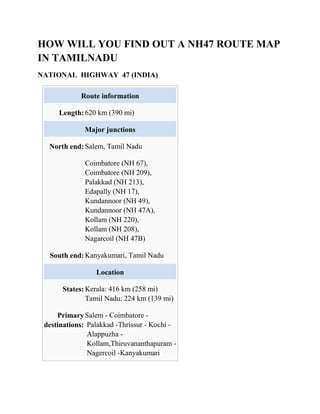
  • 1. HOW WILL YOU FIND OUT A NH47 ROUTE MAP IN TAMILNADU NATIONAL HIGHWAY 47 (INDIA) Route information Length: 620 km (390 mi) Major junctions North end: Salem, Tamil Nadu Coimbatore (NH 67), Coimbatore (NH 209), Palakkad (NH 213), Edapally (NH 17), Kundannoor (NH 49), Kundannoor (NH 47A), Kollam (NH 220), Kollam (NH 208), Nagarcoil (NH 47B) South end: Kanyakumari, Tamil Nadu Location States: Kerala: 416 km (258 mi) Tamil Nadu: 224 km (139 mi) Primary destinations: Salem - Coimbatore - Palakkad -Thrissur - Kochi - Alappuzha - Kollam,Thiruvananthapuram - Nagercoil -Kanyakumari
  • 2. Highway system Indian Road Network National Expressways State ← NH 46 NH 47A →
  • 3. National Highway 47, commonly referred to as NH 47, is a 620 km (390 mi) long highway connecting the city of Salem toKanyakumari town in southern India.  The important towns connected are Salem, Coimbatore, Palakkad, Thrissur, Kochi,Alappuzha, Kollam, Thir uvananthapuram, Nagercoil and Kanyakumari.[1]  The NH 47 runs within a few kilometers ofCoimbatore International Airport (within Coimbatore city limits), Cochin International Airport (Nedumbassery) and theThiruvananthapuram (Trivandrum) International Airport.  The Salem-Coimbatore-Kochi stretch of the highway is included in the North-South Corridor of the Indian highway system. It is currently undergoing conversion to 4 lane, with some sections 6 lane.[2][3] At the end of 2010, 40% of this stretch is 4 laned, and 35% under implementation TRAFFIC The stretch between the Industrial city of Coimbatore and the Port city of Kochi is one of the busiest in the Indian Highway system. Most of the traffic in this stretch comprises trucks carrying consumer goods, construction materials, container lorries (bound for Kochi Port and Kochi International Container Transhipment Terminal) and passenger vehicles. During night, the highway experiences a huge volume of traffic. On an average, around 8,000 lorries use this highway to reach Coimbatore every night. The highway has several motels and restaurants along the entire stretch. Fatal accidents frequently happen in this highway, mostly due to irresponsible bus drivers and over-speeding lorries colliding head on. Many number of Large Industries and Textile parks are located on this highway between Coimbatore, Erode and Tiruppur districts. Earlier the National Highway-47 which used to pass through the centre of Coimbatore city, now completely bypasses the city, with the commissioning of L&T by-pass road.
  • 4. The arterial Avinashi Road and Palakkad Road in Coimbatore city's stretch from Neelambur to Madukkarai through Ukkadam, Karumbukadai, Attuppalam, Kuniyamuthur has now been transferred to the State Highways Department, and is not part of the NH 47 anymore. In case of any mishaps on the highway, the emergency services are sometimes delayed several hours due to the volume of traffic in the Coimbatore-Salem Industrial Corridor ROUTE Salem, Sankari, Komarapalayam, Bhavani, Chithode (ErodeByepass),Nasiyanur, P erundurai, Vijayamangalam, Chengapalli,Perumanallur(bypass), New Tirupur(Netaji Apparel Park), Avinashi(bypass), Tekkalur, Karumathampatti, Kaniyur, Neelambur (Coimbatore bypass), Madukkarai (Coimbatore Bypass), K.G.Chavadi(bypass), Walayar(Tamil Nadu-Kerala Border),Kanjikode, Chandranagar (Palakkad Bypass), Alathur, Vadakkanchery, Mannuthy (ThrissurBypass), Chalakkudy, Anga maly,Aluva, Kalamassery, Edapally (KochiBypass), Vytilla (KochiBypass), Aroor, Vayalar, Cherthala, Alappuzha, Kalarcode,Punnapra, Ambalappuzha, Haripad, Ka yamkulam, Oachira, Karunagappally, Kollam, Kottiyam, Mylakkadu, Chathannoor , Paripalli, Kallambalam, Attingal,Kazhakkuttam(ThiruvananthapuramBypass), Ko valam, Nemom, Balaramapuram, Neyyattinkara, Parassala, (Kerala-TamilNadu Border), Kaliyakkavilai, Kuzhithurai,Marthandam,Azhagiamandapam Thuckalay, Parvathipuram, Nagercoil, Kottar, Suchindram and Kanyakumari.[4] STATUS Though the Government of India is investing in widening the National Highways, NH 47 is predominantly a two-lane highway for many parts of south Kerala. The stretch from Mannuthy (in Thrissur District) to Cherthala (in Alappuzha District) is almost completely four-laned along the Bypass to Cochin city. However, the junction at Edappally with NH- 17 which runs to Panvel(Navi Mumbai) via Kozhikode, Kannur, Mangalore, Goa) is a very congested junction.
  • 5. The widening of Chengapalli-Walayarstretch of North-South corridor is in process,Of this, the first stretch from Chengapalli to Nillambur in Coimbatore (42.705 km), where it would touch the already widened Coimbatore bypass, would facilitate six-lane traffic while the 12 km segment from Madukkarai(Coimbatore) to Walayar would be four-lane. Six laning from Chengapalli starts from Coimbatore Bypass section of NH- 47 and Four lane from Madukkarai on end of Coimbatore Bypass to Tamil Nadu/Kerala Border up to Walayar section of NH-47 in the State of Tamil Nadu. ROAD IMPROVEMENT Nearly 400 km (250 mi) of NH 47 between Cherthala and Salem passing through Kochi, Thrissur, Palakkad and Coimbatore is under various stages of expansion into express highway. The stretch from Thrissur to Cherthala passing through Kochi city has been widened to multiple lanes with six-lanes in many stretches. The road widening has started at the Salem End of the Highway and the 4 lane work has been completed in the Salem-Chengapalli (Km 0 to 100) stretch and there is a new bridge built on the Cauvery river at Bhavani Kooduthurai. Widening to six lanes is in progress between Perumanallur and Coimbatore city. Also, widening is in progress from Thrissur to Walayar (Kerala- Tamil Nadu Border, Palakkad District, Kerala). Of this, the stretch from Mannuthy to Vadakkanchery in Palakkad District(30 km) would facilitate six-lane traffic while the 58 km segment from Vadakkanchery to Walayar near Coimbatore would be four-lane expressway. However,delays in land acquisition has put on hold the widening of NH 47 from Cherthala to Kanyakumari through Kollam and Thiruvananthapuram. We can find the NH47 routemap in TamilNadu we can use GPSinIndia.com - the largest repository of Global Positioning System (GPS) knowledge in India.
  • 6. Global Positioning System (GPS) The Global Positioning System (GPS) is a space-based satellite navigation system that provides location and time information in all weather conditions, anywhere on or near the Earth where there is an unobstructed line of sight to four or more GPS satellites. The system provides critical capabilities to military, civil and commercial users around the world. It is maintained by the United States government and is freely accessible to anyone with a GPS receiver. The GPS project was developed in 1973 to overcome the limitations of previous navigation systems,[1] integrating ideas from several predecessors, including a number of classified engineering design studies from the 1960s. GPS was created and realized by the U.S. Department of Defense (DoD) and was originally run with 24 satellites. It became fully operational in 1994. Bradford Parkinson, Roger L. Easton, and Ivan A. Getting are credited for inventing it. Advances in technology and new demands on the existing system have now led to efforts to modernize the GPS system and implement the next generation of GPS III satellites and Next Generation Operational Control System (OCX).[2] Announcements from the Vice President and the White House in 1998 initiated these changes. In 2000, U.S. Congress authorized the modernization effort, GPS III. In addition to GPS, other systems are in use or under development. The Russian Global Navigation Satellite System (GLONASS) was developed contemporaneously with GPS, but suffered from incomplete coverage of the globe until the mid-2000s. There are also the planned European Union Galileo positioning system, Chinese Compass navigation system, and Indian Regional Navigational Satellite System. GPS Functionality GPS systems are made up of 3 segments Space Segment (SS) Control Segment (CS) User Segment (US)
  • 7. Space Segment  GPS satellites fly in circular orbits at an altitude of 20,200 km and with a period of 12 hours.  Powered by solar cells, the satellites continuously orient themselves to point their solar panels toward the sun and their antenna toward the earth.  Orbital planes are centered on the Earth  Each planes has about 55° tilt relative to Earth's equator in order to cover the polar regions.  Each satellite makes two complete orbits each sidereal day.  Sidereal - Time it takes for the Earth to turn 360 degrees in its rotation  It passes over the same location on Earth once each day.  Orbits are designed so that at the very least, six satellites are always within line of sight from any location on the planet.  There are currently 30 actively broadcasting satellites in the GPS constellation.  Redundancy is used by the additional satellites to improve the precision of GPS receiver calculations.  A non-uniform arrangement improves the reliability and availability of the system over that of a uniform system, when multiple satellites fail  This is possible due to the number of satellites in the air today Control Segment  The CS consists of 3 entities:  Master Control System  Monitor Stations  Ground Antennas Master Control Station  The master control station, located at Falcon Air Force Base in Colorado Springs, Colorado, is responsible for overall management of the remote monitoring and transmission sites.  GPS ephemeris is the tabulation of computed positions, velocities and derived right ascension and declination of GPS satellites at specific times for eventual upload to GPS satellites. Monitor Stations
  • 8.  Six monitor stations are located at Falcon Air Force Base in Colorado, Cape Canaveral, Florida, Hawaii, Ascension Island in the Atlantic Ocean, Diego Garcia Atoll in the Indian Ocean, and Kwajalein Island in the South Pacific Ocean.  Each of the monitor stations checks the exact altitude, position, speed, and overall health of the orbiting satellites.  The control segment uses measurements collected by the monitor stations to predict the behavior of each satellite's orbit and clock.  The prediction data is up-linked, or transmitted, to the satellites for transmission back to the users.  The control segment also ensures that the GPS satellite orbits and clocks remain within acceptable limits. A station can track up to 11 satellites at a time.  This "check-up" is performed twice a day, by each station, as the satellites complete their journeys around the earth.  Variations such as those caused by the gravity of the moon, sun and the pressure of solar radiation, are passed along to the master control station. Ground Antennas  Ground antennas monitor and track the satellites from horizon to horizon.  They also transmit correction information to individual satellites. User Segment  The user's GPS receiver is the US of the GPS system.  GPS receivers are generally composed of an antenna, tuned to the frequencies transmitted by the satellites, receiver-processors, and a highly- stable clock, commonly a crystal oscillator).  They can also include a display for showing location and speed information to the user.  A receiver is often described by its number of channels this signifies how many satellites it can monitor simultaneously. As of recent, receivers usually have between twelve and twenty channels.  Using the RTCM SC-104 format, GPS receivers may include an input for differential corrections.  This is typically in the form of a RS-232 port at 4,800 bps speed. Data is actually sent at a much lower rate, which limits the accuracy of the signal sent using RTCM.
  • 9.  Receivers with internal DGPS receivers are able to outclass those using external RTCM data Position Calculation  The coordinates are calculated according to the World Geodetic System WGS84 coordinate system.  The satellites are equipped with atomic clocks  Receiver uses an internal crystal oscillator-based clock that is continually updated using the signals from the satellites.  Receiver identifies each satellite's signal by its distinct C/A code pattern, then measures the time delay for each satellite.  The receiver emits an identical C/A sequence using the same seed number the satellite used.  By aligning the two sequences, the receiver can measure the delay and calculate the distance to the satellite, called the pseudorange.  Orbital position data from the Navigation Message is used to calculate the satellite's precise position. Knowing the position and the distance of a satellite indicates that the receiver is located somewhere on the surface of an imaginary sphere centered on that satellite and whose radius is the distance to it.  When four satellites are measured at the same time, the point where the four imaginary spheres meet is recorded as the location of the receiver.  Earth-based users can substitute the sphere of the planet for one satellite by using their altitude. Often, these spheres will overlap slightly instead of meeting at one point, so the receiver will yield a mathematically most- probable position. Issues That Affect Accuracy  Changing atmospheric conditions change the speed of the GPS signals as they pass through the Earth's atmosphere and ionosphere.  Effect is minimized when the satellite is directly overhead  Becomes greater for satellites nearer the horizon, since the signal is affected for a longer time.  Once the receiver's approximate location is known, a mathematical model can be used to estimate and compensate for these errors.  Clock Errors can occur when, for example, a GPS satellite is boosted back into a proper orbit.
  • 10.  The receiver's calculation of the satellite's position will be incorrect until it receives another ephemeris update.  Onboard clocks are accurate, but they suffer from partial clock drift.  GPS Jamming can be used to limit the effectiveness of the GPS signal  For example, it is believed GPS guided missles have been misled to attack non-target locations in the war in Afghanistan.  The stronger the jamming signal, the more interference can be caused to the GPS signal.  GPS signals can also be affected by multipath issues  Radio signals reflect off surrounding objects at a location. These delayed signals can cause inaccuracy.  Less severe in moving vehicles. When the GPS antenna is moving, the false solutions using reflected signals quickly fail to converge and only the direct signals result in stable solutions. Methods of Improving Accuracy  Precision monitoring  Dual Frequency Monitoring  Refers to systems that can compare two or more signals  These two frequencies are affected in two different ways. How they are affected can be predicted however  After monitoring these signals, it’s possible to calculate what the error is and eliminate it  Receivers that have the correct decryption key can decode the P(Y)-code transmitted on signals to measure the error.  Carrier-Phase Enhancement (CPGPS)  CPGPS uses the L1 carrier wave, which has a period 1000 times smaller than that of the C/A bit period, to act as an additional clock signal and resolve uncertainty.  The phase difference error in the normal GPS amounts to between 2 and 3 meters (6 to 10 ft) of ambiguity.  CPGPS works to within 1% of perfect transition to reduce the error to 3 centimeters (1 inch) of ambiguity.  By eliminating this source of error, CPGPS coupled with DGPS normally realizes between 20 and 30 centimeters (8 to 12 inches) of absolute accuracy.  Relative Kinematic Positioning (RKP)  Determination of range signal can be resolved to an accuracy of less than 10 centimeters (4 in).
  • 11.  Resolves the number of cycles in which the signal is transmitted and received by the receiver.  Accomplished by using a combination of DGPS correction data, transmitting GPS signal phase information and ambiguity resolution techniques via statistical tests — possibly with processing in real-time.  Augmentation  Relies on external information being integrated into the calculation process.  Some augmentation systems transmit additional information about sources of error.  Some provide direct measurements of how much the signal was off in the past  Another group could provide additional navigational or vehicle information to be integrated in the calculation process. Applications – 1. Military  Military GPS user equipment has been integrated into fighters, bombers, tankers, helicopters, ships, submarines, tanks, jeeps, and soldiers' equipment.  In addition to basic navigation activities, military applications of GPS include target designation of cruise missiles and precision-guided weapons and close air support.  To prevent GPS interception by the enemy, the government controls GPS receiver exports  GPS satellites also can contain nuclear detonation detectors. 2.Civilian  Automobiles are often equipped GPS receivers.  They show moving maps and information about your position on the map, speed you are traveling, buildings, highways, exits etc.  Some of the market leaders in this technology are Garmin and TomTom, not to mention the built in GPS navigational systems from automotive manufacturers.  For aircraft, GPS provides  Continuous, reliable, and accurate positioning information for all phases of flight on a global basis, freely available to all.
  • 12.  Safe, flexible, and fuel-efficient routes for airspace service providers and airspace users.  Potential decommissioning and reduction of expensive ground based navigation facilities, systems, and services.  Increased safety for surface movement operations made possible by situational awareness.  Agriculture  GPS provides precision soil sampling, data collection, and data analysis, enable localized variation of chemical applications and planting density to suit specific areas of the field.  Ability to work through low visibility field conditions such as rain, dust, fog and darkness increases productivity.  Accurately monitored yield data enables future site-specific field preparation.  Disaster Relief  Deliver disaster relief to impacted areas faster, saving lives.  Provide position information for mapping of disaster regions where little or no mapping information is available. Example, using the precise position information provided by GPS, scientists can study how strain builds up slowly over time in an attempt to characterize and possibly anticipate earthquakes in the future  Marine applications  GPS allows access to fast and accurate position, course, and speed information, saving navigators time and fuel through more efficient traffic routing.  Provides precise navigation information to boaters.  Enhances efficiency and economy for container management in port facilities.  Other Applications not mentioned here include  Railroad systems  Recreational activities (returning to the same fishing spot)  Heading information – replacing compasses now that the poles are shifting  Weather Prediction  Skydiving – taking into account winds, plane and dropzone location  Many more!