Roadspace Allocation for Better Streets
•
1 gefällt mir•1,205 views

This presentation highlights the importance of Roadspace Allocation within transport planning and illustrates how to develop a successful Roadspace Allocation Framework. Further to this the presentation gives an insight to understanding and meeting user requirements. It then progresses to utilise various case studies in Birmingham to further demonstrate how these frameworks can be put into practice.

Empfohlen
Empfohlen
Weitere ähnliche Inhalte
Was ist angesagt?
Was ist angesagt? (20)
Andere mochten auch
Andere mochten auch (20)
Ähnlich wie Roadspace Allocation for Better Streets
Ähnlich wie Roadspace Allocation for Better Streets (20)
Mehr von Design South East
Mehr von Design South East (20)
Kürzlich hochgeladen
Kürzlich hochgeladen (20)
Roadspace Allocation for Better Streets
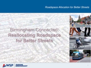
- 1. 1 Birmingham Connected: Reallocating Roadspace for Better Streets Roadspace Allocation for Better Streets
- 2. 2 Introduction Roadspace Allocation for Better Streets 1. What is Roadspace Allocation? 2. Local Context - Birmingham Connected 3. Why a Roadspace Allocation Framework? 4. Developing a Roadspace Allocation Framework 5. Street Classification 6. Understanding User Requirements 7. Meeting the User Requirements 8. Case Studies 2
- 3. 3 What is Roadspace Allocation? Roadspace Allocation for Better Streets • One of the great challenges in contemporary transport planning • Our inheritance is a highway, built around car users • In many places, not desirable • mass transit, walking and cycling becoming increasingly critical • people to make do with the periphery of a highway dominated environment • the role of high streets is changing, quality of environment is more important than ever • So how we allocate scare roadspace is critical • Difficult, inevitably means compromises
- 4. 4 Local Context - Birmingham Connected Roadspace Allocation for Better Streets • Birmingham Connected White Paper - launched 13 November 2014 • 20 year transport strategy - sets a new direction for transport • Vision is to create a transport system which puts the user first and delivers the connectivity that people and businesses require. • At the heart of the vision is an integrated mass transit network of Tram, Metro and BRT routes, underpinned by a bus network. • Ambitious plans for growth
- 5. 5 Why a Roadspace Allocation Framework? Roadspace Allocation for Better Streets • So a framework to guide roadspace allocation is critical… • Provides a mechanism for delivering vision • Translates wider requirements for networks into localised level design guidance • Provides a consistent basis for prioritising roads user requirements and allocating roadspace • Considers place function • Teases out what the priorities are, linking into Spatial Planning policy • Politicians and members can sell the compromises more easily if they can point to a compelling wider vision
- 6. 6 Developing a Roadspace Allocation Framework Roadspace Allocation for Better Streets
- 7. 7 Street Classification Roadspace Allocation for Better Streets • Link and Place – principle is to account for the competing needs of street users • Link – a road or path where users pass through • Place – a destination in its own right. • Data gathering and review exercise • Mapped datasets as layers, and applied filters to assemble Link and Place types. • Five-by-five Link and Place matrix was developed, plus… • Off-Network Sites, such as out of town shopping centres and industrial estates • Interchange sites such as rail stations. • Future networks and spatial plans
- 8. 8 Street Classification Roadspace Allocation for Better Streets • Bespoke Five-by-five Link and Place matrix for Birmingham
- 9. 9
- 10. 10 Understanding User Requirements Roadspace Allocation for Better Streets • Worked with project partners to understand the requirements of different street user groups: • street activities (driving, parking, boarding-alighting, window shopping etc. Sustrans Design Manual • Handbook for cycle-friendly design • associated street design needs (i.e. bus lane width, area of a cycle stand). • Design requirements (both minimum and desirable), to identify road space needed.
- 11. 11 Meeting the User Requirements Roadspace Allocation for Better Streets • Step 1 – Consider Street Classification: identify the link and place functions of the street section • Step 2 – Consider User Groups’ Requirements within Local Conditions/ Context: and • Step 3 – Meeting the User Requirements: allocate roadspace in accordance to the notional user hierarchy • Set out all the user requirements for the selected street section • Starting point is the idealised design requirement for each • If there is sufficient roadspace for all - no further guidance is required….
- 12. 12 Meeting the User Requirements Roadspace Allocation for Better Streets • …in all other cases the Link and Place guidance serves to adjudicate between competing user requirements • If minimum design requirements cannot be accommodated, the broad options are: a) Share the space b) Allocate the space by time c) Direction based allocation or d) Prioritising Key Users …if one or more of the user requirements (e.g. a cycle route, Sprint route, parking) may have to be reassigned/relocated. A strategic decision might be taken to downgrade the Link or Place classification, i.e. regeneration scheme or a by-pass.
- 13. 13 Case Studies - Redesigning Streets Roadspace Allocation for Better Streets • Case studies were undertaken to road-test the Link and Place framework within different street environments across Birmingham. • Through which a set of guiding principles for reallocating roadspace were established for each street type. • The outcome of this process has been ‘to guide the prioritisation of user requirements, which are translated into physical roadspace allocations through the re-design of street layouts, and the application of suitable transport schemes, initiatives and urban design elements.’ • Case Studies included…
- 14. 14 Case Studies - Redesigning Streets Roadspace Allocation for Better Streets
- 15. 15 Case Studies - Redesigning Streets Roadspace Allocation for Better Streets
- 16. 16 Case Studies - Redesigning Streets Roadspace Allocation for Better Streets
- 17. 17 Case Studies - Redesigning Streets Roadspace Allocation for Better Streets
- 18. 18 Case Studies - Redesigning Streets Roadspace Allocation for Better Streets
- 19. 19 Case Studies - Redesigning Streets Roadspace Allocation for Better Streets
- 20. 20 Case Studies - Redesigning Streets Roadspace Allocation for Better Streets
- 21. 21 Case Studies - Redesigning Streets Roadspace Allocation for Better Streets
- 22. Thanks for listening Any questions? Himanshu Budhiraja Himanshu.Budhiraja@pbworld.com 22 Delivering Sustainable Transport