Problem Identification of Traffic and Transport : Muzaffarpur City, Bihar
•
1 gefällt mir•106 views

https://irjet.net/archives/V3/i2/IRJET-V3I244.pdf

Empfohlen
Weitere ähnliche Inhalte
Was ist angesagt?
Was ist angesagt? (20)
Ähnlich wie Problem Identification of Traffic and Transport : Muzaffarpur City, Bihar
Ähnlich wie Problem Identification of Traffic and Transport : Muzaffarpur City, Bihar (20)
Mehr von IRJET Journal
Mehr von IRJET Journal (20)
Kürzlich hochgeladen
Kürzlich hochgeladen (20)
Problem Identification of Traffic and Transport : Muzaffarpur City, Bihar
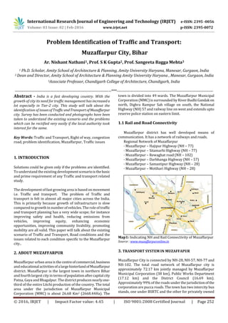
- 1. International Research Journal of Engineering and Technology (IRJET) e-ISSN: 2395 -0056 Volume: 03 Issue: 02 | Feb-2016 www.irjet.net p-ISSN: 2395-0072 © 2016, IRJET | Impact Factor value: 4.45 | ISO 9001:2008 Certified Journal | Page 252 Problem Identification of Traffic and Transport: Muzaffarpur City, Bihar Ar. Nishant Nathani1, Prof. S K Gupta2, Prof. Sangeeta Bagga Mehta3 1 Ph.D. Scholar, Amity School of Architecture & Planning, Amity University Haryana, Manesar, Gurgaon, India 2 Dean and Director, Amity School of Architecture & Planning Amity University Haryana , Manesar, Gurgaon, India 3Associate Professor, Chandigarh College of Architecture, Chandigarh, India ---------------------------------------------------------------------***--------------------------------------------------------------------- Abstract - India is a fast developing country. With the growth of city its need for traffic management has increaseda lot especially in Tier-2 city. This study will talk about the identification of issuesofTrafficandTransport ofMuzaffarpur city. Survey has been conducted and photographs have been taken to understand the existing scenario and the problems which can be rectified very easily if the local authority took interest for the same. Key Words: Traffic and Transport, Right of way, congestion road, problem identification, Muzaffarpur, Traffic issues 1. INTRODUCTION Solutions could be given only if the problems are identified. To understand the existing developmentscenarioisthebasic and prime requirement of any Traffic and transport related study. The development of fast growing area is based on movement i.e. Traffic and transport. The problem of Traffic and transport is felt in almost all major cities across the India. This is primarily because growth of infrastructure is slow compared to growth in number of vehicles. The role of traffic and transport planning has a very wide scope; for instance improving safety and health, reducing emissions from vehicles, improving equity, enhancing economic opportunities, improving community livability, promoting mobility are all valid. This paper will talk about the existing scenario of Traffic and Transport, Road conditions and the issues related to each condition specific to the Muzaffarpur city.. 2. ABOUT MUZAFFARPUR Muzaffarpur urban area is the centreofcommercial,business and educationalactivitiesofalargehinterlandofMuzaffarpur district. Muzaffarpur is the largest town in northern Bihar and fourth largest city in termsofpopulationaftercapitalcity Patna, Gaya and Bhagalpur. The districtproducesnearlyone- third of the entire Litchi production of the country. The total area under the jurisdiction of Muzaffarpur Municipal Corporation (MMC) is about 26.68 Km2 (2668.44Ha). The town is divided into 49 wards. The Muzaffarpur Municipal Corporation (MMC) is surrounded by River BudhiGandakon north, Dighra Rampur Sah village on south, the National Highway (NH) 57 and railway line on west and extends upto reserve police station on eastern limit. 1.1 Rail and Road Connectivity Muzaffarpur district has well developed means of communication. It has a network of railways and roads. Regional Network of Muzaffarpur · Muzaffarpur – Hajipur Highway (NH – 77) · Muzaffarpur – Sitamarhi Highway (NH – 77) · Muzaffarpur – Rewaghat road (NH – 102) · Muzaffarpur – Darbhanga Highway (NH – 57) · Muzaffarpur – Samastipur Highway (NH – 28) · Muzaffarpur – Motihari Highway (NH – 28) Map1: Indicating NH and Rail Connectivity of Muzaffarpur Source : www.muzaffarpuronline.in 3. TRANSPORT SYSTEM IN MUZAFFAPUR Muzaffarpur City is connected by NH-28, NH-57, NH-77 and NH-102. The total road network of Muzaffarpur city is approximately 72.17 km jointly managed by Muzaffarpur Municipal Corporation (38 km), Public Works Department (17.12 km) and the District Council (16.69 km). Approximately 99% of the roads under the jurisdictionofthe corporation are pucca roads. The town has two intercity bus stands, one under BSRTC and the other for privately owned
- 2. International Research Journal of Engineering and Technology (IRJET) e-ISSN: 2395 -0056 Volume: 03 Issue: 02 | Feb-2016 www.irjet.net p-ISSN: 2395-0072 © 2016, IRJET | Impact Factor value: 4.45 | ISO 9001:2008 Certified Journal | Page 253 buses. The key issues affecting the sector are heavy congestion, parking problems especially in the market areas and along the main thoroughfare. Encroachment ofroadsfor commercial activities and for residential use by slum dwellers, lack of parking places, no traffic signals, no road signage and inefficient traffic management are some of the key issues. The situation worsens with water logging and overflow of drains in the rains. Sl. No. Roads looked after by Number of Roads Length (km) Remarks 1 Municipal Corporation Roads 74 38.091 RoW varies between 4 and 25 m 2 PWD Roads 12 17.123 RoW varies between 8 and 30 m 3 District Council Roads 13 16.961 RoW varies between 5 and 24 m 4 Total 99 72.175 Table-1:Roads under Various Authorities in Muzaffarpur Source: Municipal Corporation, Muzaffarpur 3.1 Major Roads In Muzaffarpur Compiled data of roads, their right of way, construction material and length of road under each department like Municipal corporation, PWD and district council is listed below: S.N o. Name of the Road Type of Road Leng th (m) Widt h (m) 1 Lalit Narayan Mishra Road (Malgodawn Chowk to Kalyani Chowk) Pitch & PCC 1642 20-14 2 Mahender Marg Sadar Hospital Road (Lalit Narayan Mishra Road to Dak Ghar Chowk) Pitch & PCC 476 17-19 3 Bank Road (Dharamshala Chowk to Mahatma Gandhi Road) PCC 557 14-16 4 Nathu Chaudhary Road (Dharamshala Chowk to Chatha Chowk PCC 562 12-13 5 Laxmi Narayan Road (Dharamshala Chowk to Achal Chowk) PCC 517 7-10 6 Tilak Maidan Road (Town Thana Chowk to Navyukth Samiti) Pitch 370 7-12 7 Sariyaganj Road (Tower Chowk to Navyukth Samiti) PCC 215 10-14 8 Jawaharlal Chowk (Navyukth Samiti to Kalyani Chowk) PCC 685 10-12 9 Sutapatti Road (Bank Road to Sarriyaganj Road) PCC 256 6-11 10 Balughat Road (Akharaghat Road to Budhigandak ) Pitch & PCC 608 6-7 11 Yogender Mukherjee Road (Jawaharlal Road to Raghuvansh Road) PCC 282 6-11 12 Gola Bandh Road PCC 650 5-7 13 Raghuvansh Road PCC 510 6-13 14 Kripnath Mishr Lane (Gudri Road to Raghuvansh Road) PCC 180 4-8 15 Garibsthan Road(Chatha Bazaar Chowk to Purani Bazaar Chowk) PCC 285 6-11 16 Kaidarnath Banerjee Road(Kalyani Chowk to Durgasthan Chowk) PCC 780 9-12 17 Yadhupati Road(Nayi Bazaar Road Majhan Toil Road to Banaras Bank Chowk) Pitch 310 6-12 18 Roti Wali Lane) PCC 150 8-10 19 Mahajan Toil Road (Jumma Masjid Chowk to Pakki Sarai) Pitch 458 9-11 20 Lakdi-Dhai Road (Nawab Road to Uttarbhaya Bandh) PCC 265 10-11 21 Nawab Road (Banaras Bank Chowk to Church Road) Pitch & PCC 586 11-12 22 Azad Road (Pakki Sarai Road to Church Road) PCC 447 11 23 Maharaja Road (Azad Road to Gandak Bandh) PCC 405 10-12 24 Kurbaan Road (Bhola Chowk to Nawab Chowk) PCC 450 11 25 Church Road (Jail Chowk to Lakdi-Dhai Road) PCC 634 5-18 26 Pakki Sarai Road PCC 1053 12 27 Ali Mirza Road (Nayi Bazaar Chowk to Pakki Sarai Road) PCC 261 11-16 28 Bhaukla Road (Sahu Road to Chaturbhusthan Chowk) PCC 513 8-10 29 Kalibadi Road (Chaturbhusthan Chowk to Malighat Chowk) PCC 948 8-10
- 3. International Research Journal of Engineering and Technology (IRJET) e-ISSN: 2395 -0056 Volume: 03 Issue: 02 | Feb-2016 www.irjet.net p-ISSN: 2395-0072 © 2016, IRJET | Impact Factor value: 4.45 | ISO 9001:2008 Certified Journal | Page 254 30 Rambagh Road (Pakki Sarai Road to Sanskrit College) PCC 522 6-13 31 Kachhi Sarai Road(Chhoti Kalyani Chowk to Amar Talkis) PCC 479 8-15 32 Gudri Bazaar Road(Prabhat Sinera Road to Pakki Sarai Road) PCC 979 6-9 33 Bahel Khana Road(Gudri Bazaar Road to Kachhi Sarai Road) PCC 330 6-7 34 Pachrang Patti Road(Gaushala Chowk to Malighat Chowk) PCC 1032 19-25 35 Purani Bazaar Road(Kaidarnath Road to Sahu Road) PCC 180 9-10 36 Club Road (Kalyani Chowk to Jubbasahni Park) PCC 1061 10-12 37 Rajju Saha Lane (Club Road to Railway Line) PCC 360 5-6 38 Mukherjee Seminary Road (Club Road to Sarai Road) PCC 235 7-9 39 Society Road (Pani Tanki Chowk to Gaushala Road) PCC 550 8-9 40 Diwan Road (Club Road to Amgola Railway Sampar) Pitch & PCC 400 8-10 41 Bhayamnandan Road (Town Thana Chowk to Nathu Choudhary Road) Pitch & PCC 598 10-15 42 Nitivar Marg (Chanderlok Chowk to Kalambagh Chowk) PCC 551 20-24 43 Padav Pokhar Road(Nim Chowk to Kalam Bagh Road) PCC 814 4-5 44 Nandan Shah Marg (Nim Chowk to Atardah ke Siman ) PCC 1271 4-7 45 Refugee Road (Kalam Bagh Chowk to Ramdayalu Nagar Station) Pitch 1121 5-25 46 Chaturbhuj Thakur Marg (Kalam Bagh Road to Refugee Marg) Pitch 473 3-4 47 Damu Chowk Road (Chata Chowk to Vivekanand Road) Pitch & PCC 963 9-11 48 Maujhaulia Road (Kalam Bagh Road to Railway Pitch & 1186 6-9 Sampar No-5) PCC 49 Chaturbhuj Sthan Road (Chaturbhuj Sthan Road to Kalibadi Road) Pitch 235 8-11 50 Khabda Road (Kalam Baghroad to Railway Sampar No-6) Pitch 883 4-10 51 Spekar Road (Kalam Bagh Road to Bhayam Nandan Road) PCC 335 6-7 52 Choti Kalyani Road (Kalyani to Choti Kalyani) PCC 200 5-9 53 Imli Chatti Road (Bus Stand Chowk to Mahbub Chowk) Pitch & PCC 446 12-14 54 Mahendi Hassan Road (Motihari Road to Laxmi Chowk) Pitch 820 9 55 Iqbal Hussain Road Pitch 480 3-5 56 Soda Godaam Road Pitch 318 3-4 57 Jhatakiya Road Pitch 408 5-7 58 Juran Chapra Road-1 PCC 211 5-7 69 Juran Chapra Road-2 Pitch 202 5-6 60 Juran Chapra Road-3 PCC 257 5-6 61 Juran Chapra Road-4 Pitch 305 5-7 62 Ayodhaya Prasad Lane PCC 290 3-4 63 Majlis Sahay Lane PCC 140 3-4 64 Krishan Toil Road Pitch 647 4-9 65 Madipura School Road PCC 172 4-5 66 Chitragupt Puri Road PCC 477 7-15 67 Ram Raji Road PCC 464 3-5 68 Professor Colony Road Solin g 233 4-5 69 Bela Road PCC 529 4-6 70 Pankha Toli Road PCC 863 4-6 71 Orient Club Lane PCC 225 4-5 72 Patwa Toli Lane PCC 273 4-5 73 Pitambar Babu Lane Pitch 318 5-6 74 Data Lambal Shah Mazar Road PCC 200 6-7 Table -2 : Major Roads under Muzaffarpur Municipal Corporation Source: Draft Master Plan, Muzaffarpur –-2027 Sl. No. Name of the Road Type of Road Leng th (m) Widt h (m) 1 Motihari Road (Juran Chapra Chowk to Laxmi Chowk) Pitch 2583 14- 30 2 Rewa Ghat Road (Juran Chapra Chowk to Bhagwanpur Chowk) Pitch 1637 10- 18 3 Kachhari Road (Juran Pitch 2575 12-
- 4. International Research Journal of Engineering and Technology (IRJET) e-ISSN: 2395 -0056 Volume: 03 Issue: 02 | Feb-2016 www.irjet.net p-ISSN: 2395-0072 © 2016, IRJET | Impact Factor value: 4.45 | ISO 9001:2008 Certified Journal | Page 255 Chapra Chowk to Banaras Bank Chowk) 24 4 Hajipur Road (Purani Thana Chowk to Ramdayalu Nagar over bridge) PCC & Pitch 3294 8-22 5 Devaria Road (Brahampura Thana Chowk to Damodarpur) Pitch 1028 12- 25 6 Gaushala Road Pitch 976 16- 19 7 Madipur Chowk to Butler Chowk Pitch 615 9-12 8 Dak Bangle Road(Malgodam Chowk to Dak Bangla Chowk) Pitch 376 15- 22 9 Butler Chowk to Butler Railway Gumati Pitch 332 12- 13 10 Chakkar Road Pitch 1262 8-24 11 Sikandarpur Road Pitch 978 9-19 12 Akhada Ghat Road(Tower Chowk to Zero mile) Pitch 1467 13- 31 Table-3 : Major roads under PWD, Muzaffarpur Source: Draft Master Plan, Muzaffarpur –-2027 Sl. No. Name of the Road Type of Road Length (m) Width (m) 1 Kalam Bagh Road (Butler Chowk to Mithan Pura Chowk) PCC & Pitch 3523 5-17 2 Ladora Road (Madipur Power House Chowk to Railway Gumti) PCC & Pitch 782 13-15 3 Dalsingh Sarai Road (Masjid Chowk to Gulgula Chowk) PCC & Pitch 2314 20 4 Padmoula Road (Kachhi Pucki Road) PCC 2314 20 5 Sahpur Road (Jubba Sahnipark to Nigam Limit) PCC & Pitch 595 19-22 6 Brahampura Thana Chowk to N.H.-28 Pitch 1000 12-14 7 Ashram Road Pitch 2263 20 8 Kathal Road PCC 725 12-16 9 Major Ganj PCC & Pitch 860 8-24 10 Khadi Board to Ram Bagh Chowk Soling 439 17 11 Satpura to Bhorpur Soling 570 4-7 12 Madipur Chowk to N.H.-28 PCC 509 5-6 13 Mithan Pura Road (Bela Road to Gaushala Road) PCC 1067 11-19 Table -4: Major roads under District Council, Muzaffarpur Source: Draft Master Plan, Muzaffarpur –-2027 3.2 Classification of Urban Roads and Traffic Characteristics The type of construction of roads within Muzaffarpur is shown in Table 5. The town has about 26 km long concrete roads and 24.4 km long black top roads, together, which constitutes more than 70% of total road network. In addition, road stretches of 18 km length have been categorised as both concrete / blacktop construction.Nearly 3.7% road length (2.7 km) is kutcha. Sl. No. Surface Type Length of Roads (km) Percentage 1 Concrete Roads (PCC) 26.738 37.05% 2 Concrete Roads + Blacktop 18.273 25.32% 3 Black Topped/ Bituminous 24.440 33.86% 4 Earthen Road 2.724 3.77% Total 72.175 100% Table 2.45 Division of Roads based on Surface Type Source: Municipal Corporation Muzaffarpur 4. ISSUES IDENTIFICATION This section of the paper will talk about the issues of traffic and transport in Muzaffarpur for this author has surveyed the area and clicked photographs to address the issues. 4.1 Garbage Collection Issue There is a lack of garbage collection points in the city. Garbage pits has not been found throughout the city except some places, figure 1,2 &3 describes the scenario of garbage in the city. Figure-1: Garbage on road Source: Author
- 5. International Research Journal of Engineering and Technology (IRJET) e-ISSN: 2395 -0056 Volume: 03 Issue: 02 | Feb-2016 www.irjet.net p-ISSN: 2395-0072 © 2016, IRJET | Impact Factor value: 4.45 | ISO 9001:2008 Certified Journal | Page 256 Figure-3: Garbage in between road, Chhata Bazar Source: Author Figure-3: Garbage on road, Shukla road Source: Author 4.1.1 Issues: 1) No space for pedestrian 2) Very difficult to ride non motorized vehicle 3) Less Carriage way for movements 4) Cause of traffic congestions 5) Creates Unhygienic conditions as the animals take their food out of the garbage 6) Slow traffic as animals sits over the garbage. 7) No pedestrian movement 8) Difficult to travel NMT modes 9) Unhygienic condition 10) Movement of traffic is slow 11) Foul smell to traveller 4.2 Street Vendor Issue Most of the major roads of the city is captured by street vendors. They capture 20% -30% Right of way, where as city is already facing the narrow roads and streets. Figure 4 & 5 is indicating such street vendors on the road. 4.2.1 Issues: 1) No space for pedestrian 2) Less Carriage way for movements 3) Cause of traffic congestions 4) 30% to 40% ROW is occupied by the vendors and the customers’ Figure-4: Vegetable street vendor, Chhoti Sariaya Ganj Source: Author Figure-5: Street Food vendor Source: Author 4.3 Bottle neck at major road Bottle neck in the city is one of the major causes of slow traffic and traffic congestions. Muzaffarpur is also having such bottlenecks in the city figure 6 indicates the bottleneck point in the city 4.3.1 Issues: 1) No space for pedestrian 2) Suddenly traffic gets slow 3) Cause of traffic congestions 4) Accident prone area
- 6. International Research Journal of Engineering and Technology (IRJET) e-ISSN: 2395 -0056 Volume: 03 Issue: 02 | Feb-2016 www.irjet.net p-ISSN: 2395-0072 © 2016, IRJET | Impact Factor value: 4.45 | ISO 9001:2008 Certified Journal | Page 257 Figure-6: bottle neck at Saraiyajang Source: Author 4.4 Electric Poles On Carriage Way It has een observed that in many place the electrical poles are standing in between carrige way. Without considering the it will craete another king of bottle neck. It has aldo been observed people use space aroudthepoleasa garbagedump area , since there is no movement of vehicle near the pole. Figure 7 & 8 are showing the condition of electric pole standing in between the road. 4.4.1 Issues: 1) Place used as a garbage dump area 2) Suddenly traffic gets slow 3) Accident prone area 4) Carriage way is not utilized properly 5) Area near the pole used as a parking space Figure-7: Electric Pole on caraigeway Source: Author 4.5 Water logging Issue Drains of muzaffarpur are not designed and cleaned properly. Most of the area is facing the issue of overflow of drainge. Drains are open in nature and clogged due to non maintance issue. Grey and black water on the road creates trouble to the padestrian and other vehicular movements some of the area like Kedar nath road is facing this broblem Figure-8: Electric Pole on caraigeway Source: Author Figure-9: Overflow of drain, Kaidar Nath Road Source: Author Figure-10: Overflow of Drain Source: Author through out the year. Now the traffic and move through that road is negligible as the peaople dont want to opt theat
- 7. International Research Journal of Engineering and Technology (IRJET) e-ISSN: 2395 -0056 Volume: 03 Issue: 02 | Feb-2016 www.irjet.net p-ISSN: 2395-0072 © 2016, IRJET | Impact Factor value: 4.45 | ISO 9001:2008 Certified Journal | Page 258 route. Figure 9,10 and 11shows the scenario of water looging in usual days. 4.5.1 Issues: 1) Around the pole area used as a garbage dump area 2) Suddenly movement of traffic gets slow 3) Accident prone area 4) Carriage way is not utilized properly 5) Difficult to travel NMT modes 6) Unhygienic condition 7) Foul smell to traveller 8) Almost unused lane by travellers 9) Movement of Public transport is nil Figure-11: Open and clogged drain Source: Author 4.6 Un-organized Traffic In the city traffic is not managed properly . enforcement of traffic rule is voilated most of time by the users, this leads to trffic jam and cogestions. User dont follw their lane especially teo wheelers, bicycle and cycle rikshaw. Figure 12 indiactes the scenario of un-organized traffic Figure-12: Un-organized traffic Source: Author 4.6.1 Issues: 1) Traffic Jam 2) Pollution noise and fossil fuel 4.7 Movement of NMT modes on Flyover While designing the flyover the movement space for NMT was not provided in sufficient below the flyover so the NMT are bound to use the flyover which is difficult due to elevation of flyover. Figure 13 shows that NMT using the flyover Figure-13: Movemnt of NMT on motijheel fly over Source: Author 4.6.1 Issues: 1) Extra effort to the user 2) De-motivate the user to use NMT 3) Compelling to use motorised vehicle for travelling 4) Traffic gets slow as the NMT moves very slow in ascending direction. 5) To control NMT on descending direction is another difficult task. 4.8 Rope as a divider Due to minimal width of right of way (ROW) to design proper divider is difficult as divider will take some of the area of carriage way. So the smart solution wasthoughtof by the authority to control the traffic by dividing the road into two way road system. But in the rush hour rope isnotableto serve its purpose. Figure 14 shows the use of rope as a divider Figure-14: Rope as a divider at Tower Chowk Source: Author
- 8. International Research Journal of Engineering and Technology (IRJET) e-ISSN: 2395 -0056 Volume: 03 Issue: 02 | Feb-2016 www.irjet.net p-ISSN: 2395-0072 © 2016, IRJET | Impact Factor value: 4.45 | ISO 9001:2008 Certified Journal | Page 259 4.9 Other Issues No proper parking space in the town Intercity bus has not plied on the road Traffic is not managed properly No space for pedestrian to move Minimal carriage way to move motorised 4 wheeler IPT modes does not have proper route designated Lack in traffic signals on squares Zebra crossing is missing from entire city No speed limit Mix transport modes Right of way is shared by Cows in dogs, authority does not take proper care Garbage collection system is not proper so it is usually dumped on the ROW. Instead of tricycle electric rickshaw should be promoted Building norms and byelaws as not beenfollowedproper ly most of the building has illegal construction eating up right of way Open Drainage system which eats up the pedestrian space. Improper drainage system due to this 20% of the roads or lane are used seldom for movement Fly over is used as parking space. Poor traffic management Big poth holes, slows the traffic Speed breakers are not designed properly creates trouble for NMT as well as mechanically driven vehicle. Big vehicles like MUV’s and SUV’s are having big share on the roads eating up much of the space of limited carriageway Squares are not designed properly, so movement from one direction to another is difficult and slows down the traffic On an average length of roads are 500 mtrs. 60% - 70 % of the roads/lanes are of less than 500 mtrs. Number of turnings is higher. Bus stand is not designed properly with platforms Street vendors eating up the movement space of narrow streets 5. CONCLUSIONS It has been identified that most of the issues are related to management of traffic and transport. If the executing body and maintaining authority will work properly many of the issues may be resolved without much expenditure. Issues like open drain, overflow of drain, street vendors, electric pole etc. these issues could be resolved without much hindrance. So If the concern authority look with in and analyze the problems of traffic and transportitcanbesolved easily. REFERENCES [1] Nishant Nathani, Prof. S K Gupta, Prof. Sangeeta Bagga Mehta “Seamless Transport System for Feasible Moblity: Case Study” Volume : 6, Issue : 1, JANUARY 2016, pp 69-74, Indian Journal Of Applied Research, Journal DOI : 10.15373/2249555X [2] Prof. S K Gupta and Ar. Nishant Nathani, Urban Transport Green: India, ICETET’2013, Phuket, Thailand, pp 103-108 [3] CDP, Muzaffarpur; Urban Development and Housing Department Government of Bihar [4] National urban Transport Policy, Govt. of India [5] Draft Master Plan- Muzaffarpur-2027