១៦ ខេត្តរតនៈគីរី
•
0 gefällt mir•220 views

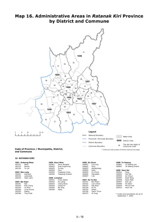
Map 16 shows the administrative areas in Ratanak Kiri Province of Cambodia, including 16 districts divided into communes. The map displays: 1) The boundaries of Ratanak Kiri province and its 16 districts. 2) Each district's commune boundaries and codes made up of the district code and 2 digits. 3) A legend explaining the symbols on the map such as provincial boundaries and district codes.

Empfohlen
Weitere ähnliche Inhalte
Was ist angesagt?
Andere mochten auch
Andere mochten auch (20)
Ähnlich wie ១៦ ខេត្តរតនៈគីរី
Ähnlich wie ១៦ ខេត្តរតនៈគីរី (6)
Kürzlich hochgeladen
Kürzlich hochgeladen (20)
១៦ ខេត្តរតនៈគីរី
- 1. Map 16. Administrative Areas in Ratanak Kiri Province by District and Commune 01 1608 02 05 10 07 1609 06 04 03 08 04 02 1601 01 09 07 04 01 03 1606 06 05 02 05 01 03 06 03 02 03 06 03 01 02 03 04 1602 01 1603 04 05 04 03 1607 06 05 05 07 1604 1605 06 01 02 04 02 01 01 0 10 20 40 km Legend National Boundary Water Area Provincial / Municipal Boundary 0000 District Code District Boundary The last two digits of Commune Boundary Commune Code* 00 Code of Province / Municipality, District, * Commune Code consists of District Code and two digits. and Commune 16 RATANAK KIRI 1601 Andoung Meas 1604 Koun Mom 1606 Ou Chum 1608 Ta Veaeng 160101 Malik 160401 Serei Mongkol 160601 Cha Ung 160801 Ta Veaeng Leu 160103 Nhang 160402 Srae Angkrorng 160602 Pouy 160802 Ta Veaeng Kraom 160104 Ta Lav 160403 Ta Ang 160603 Aekakpheap 160404 Teun 160604 Kalai 1609 Veun Sai 1602 Ban Lung 160405 Trapeang Chres 160605 Ou Chum 160901 Pong 160201 Kachanh 160406 Trapeang Kraham 160606 Sameakki 160903 Hat Pak 160202 Labansiek 160607 L'ak 160904 Ka Choun 160203 Yeak Laom 1605 Lumphat 160905 Kaoh Pang 160501 Chey Otdam 1607 Ou Ya Dav 160906 Kaoh Peak 1603 Bar Kaev 160502 Ka Laeng 160701 Bar Kham 160907 Kok Lak 160301 Kak 160503 Lbang Muoy 160702 Lum Choar 160908 Pa Kalan 160302 Keh Chong 160504 Lbang Pir 160703 Pak Nhai 160909 Phnum Kok 160303 La Minh 160505 Ba Tang 160704 Pa Te 160910 Veun Sai 160304 Lung Khung 160506 Seda 160705 Sesan 160305 Saeng 160706 Saom Thum 160306 Ting Chak 160707 Ya Tung * Codes and boundaries are as of September 7, 2009. II - 18