Morphometry and Soil Loss Estimation of Indian Watershed
•Als PPTX, PDF herunterladen•
1 gefällt mir•55 views

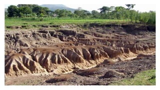
Morphometry and soil erosion

Empfohlen
Weitere ähnliche Inhalte
Was ist angesagt?
Was ist angesagt? (20)
Ähnlich wie Morphometry and Soil Loss Estimation of Indian Watershed
Ähnlich wie Morphometry and Soil Loss Estimation of Indian Watershed (20)
Kürzlich hochgeladen
Kürzlich hochgeladen (20)
Morphometry and Soil Loss Estimation of Indian Watershed
- 1. Morphometry and soil loss estimation of Naviluthirtha watershed
- 2. CONTENTS • Introduction • Literature review • Study area • Methodology • Results and discussions • Conclusions • References
- 3. 1.INTRODUCTION. • Land and water are the two vital natural resources, which suffer tremendous stress due to ever increasing biotic pressure. • A watershed provides a limited surface area within which physical processes pertaining to the morphology and hydrology could be appreciated. • Morphometric analysis helps us to understand the physical parameters of watershed. • The over exploitation of watershed is causing depletion of soil and other resources leading to degradation of watersheds, to prevent this from happening, studies must be carried out and the standards must be set.
- 4. 1.1 OBJECTIVES • Morphometric analysis • Hypsometric analysis • Soil loss estimation using Universal soil loss equation (USLE). • Developing indexes and semi-quantitative model for soil loss estimation.
- 5. 3. STUDY AREA Figure 1. Location Map of Naviluthirtha Watershed. • Malaprabha dam which is located near Soudatti and called as Naviluthirtha dam (Renuka sagar) is taken up for the study. • longitude of 750, 10', 00'' East and latitude of 160, 05', 00'' North • Catchment area Naviluthirtha watershed is 2240 km2 • Naviluthirtha watershed comes under the Krishna upper catchment; this study area contains three major sub watersheds according to the watershed atlas of India 2014 classification. Codes for these three subwatersheds are C04KRU57, C04KRU58 and C04KRU59. • Survey of India topo maps which cover the study area are 48I/5, 48I/6, 48I/9, 48I/10, 48I/13, 48I/14, 48M/1 and 48M/2.
- 6. 4. METHODOLOGY 4.1 Morphometric Analysis : morphometric analysis gives a way to compare the different characteristics of the watershed by quantifying them into dimensionless numbers and ratios. It has three groups: 1) Linear Aspects 2) Aerial Aspects 3) Relief Aspects
- 7. 4.2 HYPSOMETRY • Hypsometric analysis is the study of the distribution of ground surface area, or horizontal cross-sectional area, of a landmass with respect to elevation. • The simplest form of hypsometric curve (hypsographic curve) is that in absolute units of measure. On the ordinate is plotted elevation in feet or meters; on the abscissa the area in square miles or kilometers lying above a contour of given elevation. • The areas used are therefore those of horizontal slices of the topography at any given level. This method produces a cumulative curve, any point on which expresses the total area lying above that plane. Figure 2. Figure of Reference in Percentage Hypsometric Analysis(A N Strahler, 1964)
- 8. • The percentage hypsometric method used in this investigation relates the area enclosed between a given contour and the upper (headward) segment of the basin perimeter to the height of that contour above the basal plane. • Two ratios are involved: (1) ratio of area between the contour and the upper perimeter (Area a) to total drainage basin area (Area A), represented by the abscissa on the coordinate system. (2) Ratio of height of contour above base (h) to total height of basin (H), represented by values of the ordinate. • The resulting hypsometric curve permits the comparison of forms of basins of different sizes and elevations. It expresses simply the manner in which the volume lying beneath the ground surface is distributed from base to top. The curve must always originate in the upper left-hand corner of the square (x = 0, y = 1) and reach the lower right hand corner (x = 1, y = 0). Figure 3. The Percentage Hypsometric Curve. ( strahler,1964)
- 9. 4.3 UNIVERSAL SOIL LOSS EQUATION (USLE) • Wischmeier and Smith, 1965 suggested USLE model to estimate soil loss from watershed. The equation is as follows: A (t/ha/yr) = RKLSCP where, A = Computed soil loss (t/ha/yr) R = Rainfall erosivity factor K = Soil erodibility factor L = Slope length factor S = Slope steepness factor C = Cover and management factor P = Conservation practice factor
- 10. • R Factor: The rainfall erosivity factor is a function of falling raindrops and the rainfall intensity. Wischmeier and Smith (1958) found that the product of kinetic energy of the raindrop and the maximum intensity of rainfall over duration of 30 minutes, in a storm, is the best estimator of soil loss. This product is known as the Erosion Index (EI) value. Figure 4. Isopleath of EI30 annual of India (Raghunath et al.1982)
- 11. • Soil erodibility factor (K) The soil erodibility factor (K) relates the rate at which different soils erode under the conditions of equal slope, rainfall. Some soils erode more easily than others due to inherent soil characteristics such as texture, structure, permeability and organic matter content. 100K = 2.1×10⁻⁴(𝑁1. 𝑁2)1.14 (12-OM)+3.25(S-2)+2.5(P-3) where, K = Soil erodibility factor. N1, N2= Particle size parameter (% silt + % very fined sand). OM = Percentage of organic matter content. S = Soil structure code (very fine granular=1; fine granular= 2; medium or coarse granular=3; blocky, platy, or massive=4). P = profile permeability class (rapid = 1; moderate to rapid=2; moderate=3; slow to moderate=4; slow=5; very slow=6) The soil erodobility factor can also be found out by method given by the Williams (1995) K = A*B*C*D*0.1317 Where, A = [0.2+0.3 e(-0.0256SAN(1-SIL/100)] B = [ 𝑆𝐼𝐿 𝐶𝐿𝐴+𝑆𝐼𝐿 ]0.3 C = [1.0 - 0.25𝐶 𝐶+exp 3.72−2.95𝐶 ] D = [1.0 - 0.70𝑆𝑁1 𝑆𝑁1+exp[ −5.41+22.9𝑆𝑁1 ] ] Where SAN, SIL, CLA are present sand, silt and clay, respectively; C is the organic carbon content; and SN1 is sand content subtracted from 1 and divided by 100.
- 12. • Slope length factor (L) The slope length and gradient are represented in the USLE as L and S respectively. Slope length is defined as the distance from the point of origin of overland flow to the point where either the slope gradient decreases enough that deposition begins or the runoff water enters a well-defined channel that may be a part of a drainage network or a constructed channel. Slope length factor, can be computed from the following equation L = l 22 m Where, L = slope length factor l = slope length in m m = dimensionless exponent 0.5 for slopes > 4 %; 0.4 for 4% slope; 0.3 for slopes < 3% • Slope steepness factor (S) Slope steepness factor represents the effect of slope steepness on the erosion. The effect of slope steepness have greater impact on soil loss than slope length. Greater the slope greater is the erosion. As per Wischmeier and Smith (1965), slope gradient factor is determined by the formula. S = 0.43+O.3 θ + 0.043(θ)2 6.574 where, S = slope steepness factor Ɵ = field slope in percent
- 13. • Cover and management factor (C) Factor C in the soil loss equation is the ratio of soil loss from land cropped under specified conditions to the corresponding loss from clean tilled, continuous fallow. This factor measures the combined effect of all the interrelated cover and management variables. The relative impact of management option can be easily compared with making changes in C factor which varies from near zero for a well protected landcover to 1 for barren areas. • Conservation practice factor (P) Conservation practice factor is the ratio of soil loss with a specific supporting practice to the corresponding loss with up and down cultivation. In general, whenever sloping land is to be cultivated and exposed to erosive rain, the protection offered by soil or close growing crops in the system needs to be supported by practices that will slow runoff and thus reduce the amount of soil it carries. The most important support practices are contour cultivation; strip cropping, terrace system and waterways for the disposal of excess rainfall. The values are selected based on the supporting practice adopted.
- 14. 4.4 Semi-quantitative method. • Semi-quantitative means yielding an approximation of the quantity or amount of a substance between qualitative and quantitative result. • Semi-quantitative methods require less amount of data as compared to other soil erosion models. • In this methods the parameters that affect the soil erosion process the most are selected according the data availability, and their effect on soil erosion are rated with the severity numbers. • May be like 1 for the rating as the least affective, 2 for medium and 3 for severely affecting. • Area of the watershed is the factor that affects the soil loss most to derive the correlation observed soil erosion for the subwatersheds are plotted with area. • Area vs observed soil loss alone can not explain all the soil erosion process, hence comes the semi- quantification that is developing the indices to explain the remaining soil erosion process. • Parameter Rating is done and the indices are added for individual subwatersheds and are plotted with the residual soil losses to obtain the remaining correlation.
- 15. • The model efficiency can be checked by the Nash and Sutcliff model efficiency formula ME = 1 − 𝑖=1 𝑛 (0𝑖−𝑃𝑖)2 𝑖=1 𝑛 (𝑂𝑖−𝑂𝑚𝑒𝑎𝑛)2 • Relative root mean square error is calculated by RRMSE = 1/𝑛 𝑖=1 𝑛 (𝑂𝑖−𝑃𝑖)2 1/𝑛 𝑖=1 𝑛 𝑂𝑖 Where, Oi are the observed (USLE) values Pi are predicted values from the semi-quantitative method Omean mean of observed values • The model efficiency can range from -∞ to 1. So close the ME approaches to 1, the more efficient the model is. Instead, negative values of the model produce more variation than could be observed. The RRMSE is independent on units in which the values are expressed. The smaller the RRMSE value, the more accurate is the model.
- 16. 5.RESULTS AND DISCUSSIONS Naviluthirtha watershed has dendritic drainage pattern(which looks like tree branches with lots of twigs) Figure 5. Drainage map of Naviluthirtha watershed Table 1. Basin parameters. Basin Parameters Area (km2) 2239.09 Perimeter (km) 294.96 Length(km) 96.37 Width(km) 50.04 Maximum elevation(m) +1036 Minimum elevation(m) +607
- 17. Linear aspects Table 2. Linear aspects. Stream Order No of segments Total length(km) Bf Ratio Mean Length(km) Cumulative length(km) Length ratio Drainage density (km/km2 ) 1 1052 922.11 0.87 922.11 2 295 526.33 3.56 1.78 1448.45 2.03 0.87 3 67 233.48 4.40 3.48 1681.93 1.95 4 16 162.32 4.18 10.14 1844.25 2.91 5 4 32.34 4 8.08 1876.59 0.79 6 1 76.66 4 76.66 1953.25 9.48 • The high bifurcation values may be due to steep dipping strata, where narrow valleys are confined between the ridges. Also high values of bifurcation ratio indicate elongated shape of the watershed. • The huge change in the no of segments of the lower order to upper order is indication of steep upper strata and higher order stream have more length indicating flat and permeable strata. • Drainage density of the watershed very low. Which on highly permeable landscape with small potential for runoff occurs. Low drainage density depicts the very coarse texture of watershed.
- 18. AREAL AND RELIEF ASPECTS AREAL ASPECTS Form factor Compactness Coefficient Shape factor Circularity ratio Elongation ratio Constant of channel maintenance stream frequency 0.5193 1.758 4.147 0.323 0.554 1.146 0.641 • low values of form factor, circularity ratio and higher elongation ratios, shape factor and compactness coefficient indicate the elongation property of the watershed. • The watershed has got low stream frequency. Relief aspects Relief(m) Relief ratio Relative relief Ruggedness number 429 0.00445 0.00145 0.00037 Table 3: Areal and Relief aspect calculations.
- 19. HYPSOMETRY 0 0.2 0.4 0.6 0.8 1 1.2 0 0.2 0.4 0.6 0.8 1 h/H a/A • The percentage hypsometric curve normalizes the size of the watershed and it can be easily compared with other watersheds. Naviluthirtha watershed has the hypsometric integral of 19.2%, which is very low and based on the hypsometric classification given by strahler basin is under the monadnock stage. This stage indicates the steep upper areas the flat lower terrain. • The monadnock phase is the transitory phase, with hypsometric integral below 35%. Hypsometric curve of monadnock phase looks concave in shape. Figure 7. Relative hypsometric curve
- 20. UNIVERSAL SOIL LOSS EQUATION(USLE) • R is taken as 75 for the Naviluthirtha watershed which is taken from the published isopleah map of India by Raghunath(1982) • The rainfall erodibility factor (K) obtained is 0.072. the calculations are shown in the table below Soil type CLAY(%) SAND(%) SILT(%) OM(%) AREA (km2) (A) (B) (C) (D) K K USLE CL 31.00 29.00 40.00 0.78 529.69 0.203 0.842 0.960 1.0 0.165 0.022 ML 21.00 26.80 52.20 1.15 55.93 0.211 0.904 0.887 1.0 0.169 0.022 C 55.10 7.20 37.70 0.50 217.29 0.295 0.763 0.987 1.0 0.222 0.029 C 55.50 13.60 30.90 0.40 26.01 0.227 0.735 0.992 1.0 0.166 0.022 ML 21.00 26.80 52.20 1.15 138.29 0.211 0.904 0.887 1.0 0.169 0.022 SCL 29.60 56.10 14.30 4.51 460.21 0.200 0.714 0.750 0.99 0.107 0.014 L 23.40 36.60 40.00 1.29 233.01 0.201 0.871 0.854 1.0 0.150 0.020 SCL 32.20 52.50 15.30 2.23 191.59 0.200 0.712 0.756 0.99 0.108 0.014 ML 21.00 26.80 52.20 1.15 307.93 0.211 0.904 0.887 1.0 0.169 0.022 SL 14.90 69.60 15.50 0.45 44.97 0.200 0.817 0.990 0.95 0.154 0.020 L 23.40 36.60 40.00 1.29 112.64 0.201 0.871 0.854 1.0 0.150 0.020 Table 4. Soil Erodibility calculations
- 21. • Malapraabha comes under krishnaupper catchment. And broadly divided into three subwatersheds according to the watershed atlas of India, their codes are C04KRU57, C04KRU58 and C04KRU59. • To assess the soil loss accurately the Naviluthirtha catchment into 22 subwatersheds as shown. • Soil losses are calculated for each subwatershed individually. Figure 6. Subwatersheds of Naviluthirtha
- 22. Figure 7. soil map of Naviluthirtha watershed (NIVA) Figure 8. Soil erodibility factor map for Naviluthirtha watershed
- 23. • As the majority of the slope lies above 4%, m value is taken as 0.5 for the length factor. • The major crops of Belagavi are paddy, maize, jowar and sugarcane, based on these cropping patterns the crop management factor is taken as 0.45. • As no conservation practice are followed in cropping to reduce the soil losses the conservation practice factor is taken unity. • The total soil loss estimated comes to be 2.16 t/ha/yr, which fall in nil to slight category of classification. Figure 9. Slope map of Naviluthirtha watershed
- 24. ID Y X(km) X(m) Y/X Θ m S L LS K R C P A(t/ha/yr) A(t/km2/yr) 1 340 22.55 22550 0.015 1.146 0.5 0.126 8.002 1.011 0.022 100 0.45 1 4.00 400.30 2 344 13.14 13140 0.026 1.718 0.5 0.163 6.805 1.110 0.0197 100 0.45 1 3.53 353.39 3 384 11.45 11450 0.034 1.718 0.5 0.163 6.530 1.065 0.021 100 0.45 1 3.52 351.65 4 347 16.52 16520 0.021 1.146 0.5 0.126 7.289 0.921 0.021 100 0.45 1 3.27 327.05 5 279 9.73 9730 0.029 1.718 0.5 0.163 6.219 1.014 0.0196 90 0.45 1 2.72 272.30 6 171 11.16 11160 0.015 1.146 0.5 0.126 6.480 0.818 0.0205 90 0.45 1 2.36 236.17 7 237 15 15000 0.016 1.146 0.5 0.126 7.081 0.894 0.0169 95 0.45 1 2.38 238.26 8 179 13.6 13600 0.013 0.573 0.5 0.094 6.876 0.644 0.0173 80 0.45 1 1.45 145.10 9 270 16.09 16090 0.017 1.146 0.5 0.126 7.232 0.913 0.018 80 0.45 1 2.21 221.33 10 245 19.6 19600 0.013 0.573 0.5 0.094 7.673 0.719 0.017 80 0.45 1 1.71 171.17 11 121 9.62 9620 0.013 0.573 0.5 0.094 6.198 0.581 0.0188 80 0.45 1 1.33 132.62 12 117 5.73 5730 0.02 1.146 0.5 0.126 5.305 0.670 0.0171 80 0.45 1 1.25 125.47 13 145 14.78 14780 0.01 0.573 0.5 0.094 7.050 0.661 0.0195 80 0.45 1 1.71 170.50 14 169 12.92 12920 0.013 0.573 0.5 0.094 6.771 0.634 0.0245 70 0.45 1 1.75 175.25 15 175 17.01 17010 0.01 0.573 0.5 0.094 7.353 0.689 0.023 65 0.45 1 1.75 175.29 16 105 10.53 10530 0.01 0.573 0.5 0.094 6.368 0.597 0.024 60 0.45 1 1.33 132.84 17 135 18.44 18440 0.007 0.573 0.5 0.094 7.534 0.706 0.0192 60 0.45 1 1.41 140.64 18 75 5.22 5220 0.014 0.573 0.5 0.094 5.159 0.483 0.024 60 0.45 1 0.94 93.53 19 109 10.05 10050 0.011 0.573 0.5 0.094 6.279 0.588 0.0175 60 0.45 1 0.95 94.64 20 173 11.13 11130 0.016 1.146 0.5 0.126 6.475 0.818 0.0239 60 0.45 1 1.83 183.31 21 240 11.72 11720 0.02 1.146 0.5 0.126 6.576 0.831 0.02 45 0.45 1 1.18 118.06 22 235 15.53 15530 0.015 1.146 0.5 0.126 7.155 0.904 0.0204 40 0.45 1 1.23 123.22 Table 6. Soil loss calculations
- 25. Semi-quantitative Method y = 16.469x0.5303 R² = 0.3385 0 50 100 150 200 250 300 350 400 450 0 20 40 60 80 100 120 140 160 180 Soilloss(t/km2/yr) Area (km2) • The graph gives the best fit equation between the soil loss observed for subwatersheds and respective areas. • The best fit equation is generated with R2 value of 0.3385 y = 16.469* x0.5303 Where y is soil loss in t/km2/yr and x is area • However large part of the large variation in soil loss is not explained by area. • The six parameters that are used here for the developing the indexes are rainfall erosivity, soil, slope, geology, shape and landuse landcover. Figure 10. Area Vs Soil loss
- 26. Factor Description Ratings Rainfall erosivity ≥90 3 >60 2 ≤60 1 Geology Phyllite, Schist 3 Laterite, Basalt 2 Sandstone, Limestone, Conglomerate, granite 1 Soil Loam and silts are highly susceptible to erosion. 3 Clay with loam, silts ,sand are moderately erodible 2 Clay is very resistant to erosion 1 Slope Steep upland slopes (>30%). 3 Moderate upland slopes (<20%). 2 Gentle slopes (<5%) 1 Shape Semi-circular basin shape with many streams draining. 3 Between elongated and semicircular basin shape. 2 Elongated basin shapes. 1 ID GEO R SOIL SLOPE SHAPE LULC INDEX 1 2 3 3 2 1 1 36 2 2 3 2 1 3 1 36 3 1 3 2 2 3 1 36 4 3 3 2 2 1 1 36 5 1 3 3 1 2 2 36 6 1 3 3 1 3 1 27 7 1 3 2 1 2 1 12 8 1 2 2 1 2 1 8 9 2 2 2 1 3 1 24 10 2 2 2 2 1 1 16 11 1 2 1 1 1 1 2 12 1 2 2 1 1 1 4 13 1 2 1 1 1 1 2 14 1 2 1 1 2 1 4 15 1 2 1 1 1 1 2 16 1 1 1 1 1 2 2 17 1 1 2 1 1 2 4 18 1 1 1 1 1 1 1 19 2 1 2 1 3 1 12 20 1 1 1 1 2 2 4 21 1 1 1 1 2 2 4 22 1 1 1 1 2 1 2 Table 7. Description of the factors with their ratings Table 8. Index scores for all the subwatersheds
- 27. ID INDEX A(t/km2/yr) PSL RSL AREA(km2) 1 36 400.30 233.88 -166.42 148.928 2 36 353.39 209.99 -143.40 121.544 3 36 351.65 198.27 -153.38 109.070 4 36 327.05 227.20 -99.85 141.012 5 36 272.30 250.78 -21.52 169.868 6 27 236.17 171.99 -64.17 83.418 7 12 238.26 194.70 -43.56 105.397 8 8 145.10 237.68 92.58 153.524 9 24 221.33 200.44 -20.89 111.326 10 16 171.17 194.29 23.12 104.976 11 2 132.62 141.38 8.77 57.645 12 4 125.47 115.03 -10.45 39.068 13 2 170.50 152.37 -18.13 66.382 14 4 175.25 206.59 31.34 117.860 15 2 175.29 211.60 36.31 123.310 16 2 132.84 111.83 -21.01 37.045 17 4 140.64 198.90 58.26 109.721 18 1 93.53 113.35 19.82 37.999 19 12 94.63 137.32 42.69 54.563 20 4 183.31 173.47 -9.85 84.769 21 4 118.06 200.72 82.66 111.621 22 2 123.22 234.87 111.65 150.117 • Here PSL are the predicted soil loss from the equation got from the soil loss and area plot. • Residual soil loss is calculated by subtracting observed soil loss from predicted soil loss. • Total indexes for the subwatersheds are obtained by multiplying the individual index ratings that are given to the parameters of that watershed. • Then residual soil loss is plotted with the indexes and the best fit is generated. Table 9. RSL calculations
- 28. y = -4.2599x + 47.961 R² = 0.6095 -200.00 -150.00 -100.00 -50.00 0.00 50.00 100.00 150.00 0 5 10 15 20 25 30 35 40 ResidualSoilloss(t/ha/yr) Index values • The best fit equation obtained from the index and residual soil loss is y = -4.2599x+47.961 With R2 = 0.6095 Where, y is residual soil loss x is index values • The combined model is given by soil loss = 16.469* Area0.5303 +4.2599*index-47.961 • Model efficiency of the model comes out to be 0.92 and the RRMSE is 0.23. Figure 11. Index Vs Residual soil loss
- 29. 0 50 100 150 200 250 300 350 400 450 0 50 100 150 200 250 300 350 400 450 ObservedSL(t/km2/yr) Predicted SL (t/km2/yr) R2 = 0.73 Figure 12. Validation curve (predicted Vs observed).
- 30. CONCLUSIONS • The drainage patterns of the basin found dendritic. The basin includes sixth order stream and lower stream order mostly dominate the basin. • The basin shape is elongated. • Very small value of drainage (0.8724 km/km2) density indicates the coarse texture of the watershed. • Naviluthirtha basin has the hypsometric integral of 19.2%, which is very low and based on the hypsometric classification given by Strahler basin is under the monadnock stage. This stage indicates the steep upper areas the flat lower terrain. • Soil erosion according to the universal soil loss equation is 2.16 t/ha/yr which is nil to slight category of soil erosion severity. • Indexes are developed for the watershed with resulting model efficiency of 0.92 and RRMSE of 0.23.
- 31. REFERENCES • B.P.Ganasri, H.Ramesh (2016) Assessment of soil erosion by RUSLE model using remote sensing and GIS: A case study of Nethravati basin. Geoscience frontiers,7(2016) 953-961. • Raghunath et al.(1982) • Strahler, A. N. 1952. ‘Hypsometric (area–altitude) analysis of erosional topography’, Geological Society of America Bulletin, 63, 1117– 1142. • Strahler, A. N. 1964. ‘Quantitative geomorphology of drainage basins and channel networks’, in Chow, V. T. (Ed.) Handbook of Applied Hydrology, McGraw Hill, New York, 4-39–4-76. • USDA, 1972, United States Department of Agriculture Earth Science (I.T.C), Enschede, The Netherlands, Amsterdam, Oxford, New York • W.H Wischmier, DD Smith(1965) Universal soil loss equation Agricultural Handbook 282 USDA- ARS, USA. • Joris de Vente, Jean Poesen, Gert Verstraeten(2005) The application of Semi-Quantitative Methods and Reservoir Sedimentation rates for prediction of basin sediment yield in Spain. Journal of Hydrology 305 (2005) 63–8
- 32. THANK YOU