SlideShare ist ein Scribd-Unternehmen logo
1 von 28
Downloaden Sie, um offline zu lesen
Steep #3
3.1 Reporting / Decision
making with community
and partners.
3.2 Examples
Steep#1 (3 days)
1.1 Data Preparation J-3
1.2 UAV Flight
1.2 Mapping Party OSM
Data collection (picture).
Steep #2 (7 days)
2.1 Focus group
2.2 First Simulation
(slope, Elevation model
for Hydro)
Keys Words:
Focus group
Validation
Flood simulation
Keys Words:
Decising making
Community partners
Keys Words :
Data preparation
Mapping party
Human-Centered approach in
Urban area with OpenStreetMap
Collection of spatial data:
Admin, Road, settlement, analysis (damage assessment, flood,
etc) . Satellite image / Drone image
for FLOOD simulation
Orthophoto
Digital Surface Model
UAV
VALIDATION
Water level
Discharge measurement
UAV orthophoto
Land cover
Cleansing DSM
Existing
Satellite: Orthophoto, Digital Terrain Model (DTM)
GIS information: Locals, Open data platform (Open Street Map)
Hydro meteorological information: Precipitation, discharge
1.1 Data Preparation
Map your environment with local the
community during a mapping party.
OPEN DATA is available
Yes
Integrate them
inside
OpenStreetMap
Database.
No
UAV mission. Utilization steps
UAV flight plan
3D points from 2D Keypoint matches.
3D visualisation of River Digital Surface Model points cloud
High: 54
Low: 18
Elevation:
UAV Digital Surface Model (DSM)
Haiti, 3D visualisation of Canaan's zone. 1 meters contour lines
UAV Digital Surface Model (DSM)
Port Au Prince, Orthomosaic of Canaan. Rectification and fusion of Red, Green, Blue and Near infra red spectral bands. False colour visualisation
UAV Orthophoto
High: 42
Low: 25
High: 54
Low: 18
Haiti, university of Limonade. Digital Terrain Model (DTM) 10 cm resolution
Elevation:
Elevation:
UAV Digital Surface Model (DSM)
Haiti, Port au Prince. Google satellite orthophoto;
40cm pixel size resolution
UAV orthophoto; 4 cm pixel size resolution
UAV Images
Steep #2
2.1 Community Audit
.
- Need Assessment
- Outcomes mapping
- Focus group
- Problem /Solution
Steep #2
2.1 Participatory GIS
.
2 - Participatory GIS in risk reduction (Cite Soleil) with OSM platform
2.1 – Discussion with Focus group Training
2.2 – Survey with walking paper and form
2.3 – Editing JOSM
✓ Participatory mapping makes possible to
update geographic information and plan
interventions together
Steep #2
2.1 Survey
Canal survey in Cite Soleil for risk reduction project
.
Steep #2
2.1 Survey
Road assessment using OSM plateform (per section)
Land Use
Bridges
Storage areas
Lateral structures
Stream network
….
Manning’s coefficent
CN, Curve Number
….
Data cleansing
Hydro metereological
information
Precipitations
Discharge measurement
….
Steep #2
2.1 Data flood for simulation
1st Hydraulic simulation
1st Simulation
Problem!
Too many information
1st Hydraulic simulation
Data cleansing
Z
Haiti, Martisan’s basin. Land Cover
Feature Classification Feature Segmentation Feature-based image analyse
Haiti, Martissant zone. Hydraulic simulation showing water level extent. Below, zoom in two urban zones
Haiti, Martissant zone. Hydraulic simulation showing water speed and photos of field flood level
RAIN SEASONDRY SEASON
Haiti, Grand Goave. GIS map of hydraulic simulation showing water level during dry and rain season
X [m]
Z [m]
X [m]
Z [m]
Haiti, Grand Goave. Cross-Section plot showing water level during dry and rain season
RAIN SEASON
XZ plot Cross-Section
DRY SEASON
XZ plot Cross-Section
Haiti, Grand Goave. 3D visualisation of water flood extent and river-network Cross-Sections
River cross sections. XY sections visualisation overlapped on WorldView satellite image
Hec-RAS 3D visualisation of river cross section
generated each 10 m river course distances
Sensor:
The non-intrusive nature (not submerged) of this
solution means that it continues to function during
extreme events such as flooding. Designed as a
hydrometric information service it is a "4 in 1" data
and measurement display system (height,
velocity, discharge) making it possible to:
 create and update a rating curve using a number of
discharge estimates calculated by the software
using the images;
 obtain two discharge calculations: the discharge
estimated by the current rating curve (Q)
systematically, as well as the discharge estimated
using the surface velocity measured (Qcalc) on an
ad hoc basis;
 detect changes in hydraulic behaviour (i.e. rating
curve shift)
Steep #2
2.1 Community Validation
Steep #3
3.2 Example of community decision making
Cleaning of wastewater canals
Soley Leve, quartier by quartier
change on the ground, in Cité
Soleil. Blocks organize to improve
their own neighborhood. This
map traces their progress,,,
Steep #3
3.2 Example of community decision making
Cleaning of wastewater canals.
International community took credit for
this work. Local community removed the
advertising board .
Steep #3
3.2 Example of community decision making Recycling plastic

Weitere ähnliche Inhalte

Was ist angesagt?

Digital Elevation Models
Digital Elevation ModelsDigital Elevation Models
Digital Elevation ModelsBernd Flmla
 
Flood Map Desktop for ArcGIS
Flood Map Desktop for ArcGISFlood Map Desktop for ArcGIS
Flood Map Desktop for ArcGISEmilySzajna
 
Digital Elevation Models - WUR - Grontmij
Digital Elevation Models - WUR - GrontmijDigital Elevation Models - WUR - Grontmij
Digital Elevation Models - WUR - GrontmijXander Bakker
 
Remote Sensing in Digital Model Elevation
Remote Sensing in Digital Model ElevationRemote Sensing in Digital Model Elevation
Remote Sensing in Digital Model ElevationShishir Meshram
 
2018 GIS in Government: Pits and False Hills and Spikes, Oh My Fixing Blunder...
2018 GIS in Government: Pits and False Hills and Spikes, Oh My Fixing Blunder...2018 GIS in Government: Pits and False Hills and Spikes, Oh My Fixing Blunder...
2018 GIS in Government: Pits and False Hills and Spikes, Oh My Fixing Blunder...GIS in the Rockies
 
3D Analyst - Watershed, Tomohon
3D Analyst - Watershed, Tomohon3D Analyst - Watershed, Tomohon
3D Analyst - Watershed, TomohonHartanto Sanjaya
 
Watershed Delineation in ArcGIS
Watershed Delineation in ArcGISWatershed Delineation in ArcGIS
Watershed Delineation in ArcGISArthur Green
 
Watershed analysis using GIS
Watershed analysis using GISWatershed analysis using GIS
Watershed analysis using GISAya Osman
 
3D Analyst - Watershed and Stream Network
3D Analyst - Watershed and Stream Network3D Analyst - Watershed and Stream Network
3D Analyst - Watershed and Stream NetworkHartanto Sanjaya
 
LINUX Tag 2008: 4D Data Visualisation and Quality Control
LINUX Tag 2008: 4D Data Visualisation and Quality ControlLINUX Tag 2008: 4D Data Visualisation and Quality Control
LINUX Tag 2008: 4D Data Visualisation and Quality ControlPeter Löwe
 
3D Analyst - Watershed, Lombok
3D Analyst - Watershed, Lombok3D Analyst - Watershed, Lombok
3D Analyst - Watershed, LombokHartanto Sanjaya
 
3D Analyst - Lake, Jatiluhur
3D Analyst - Lake, Jatiluhur3D Analyst - Lake, Jatiluhur
3D Analyst - Lake, JatiluhurHartanto Sanjaya
 
Watershed Delineation Using ArcMap
Watershed Delineation Using ArcMapWatershed Delineation Using ArcMap
Watershed Delineation Using ArcMapArthur Green
 
NDGISUC2017 - New Lidar Technologies for 3DEP
NDGISUC2017 - New Lidar Technologies for 3DEPNDGISUC2017 - New Lidar Technologies for 3DEP
NDGISUC2017 - New Lidar Technologies for 3DEPNorth Dakota GIS Hub
 
1 catchment delineation.ppt
1 catchment delineation.ppt1 catchment delineation.ppt
1 catchment delineation.pptmarwan B
 
Map to Image Georeferencing using ERDAS software
 Map  to Image Georeferencing using ERDAS software Map  to Image Georeferencing using ERDAS software
Map to Image Georeferencing using ERDAS softwareSwetha A
 
Geospatial Applications in Civil Engineering
Geospatial Applications in Civil EngineeringGeospatial Applications in Civil Engineering
Geospatial Applications in Civil EngineeringSriharsha Rangineni
 

Was ist angesagt? (20)

Digital Elevation Models
Digital Elevation ModelsDigital Elevation Models
Digital Elevation Models
 
Flood Map Desktop for ArcGIS
Flood Map Desktop for ArcGISFlood Map Desktop for ArcGIS
Flood Map Desktop for ArcGIS
 
Digital Elevation Models - WUR - Grontmij
Digital Elevation Models - WUR - GrontmijDigital Elevation Models - WUR - Grontmij
Digital Elevation Models - WUR - Grontmij
 
Remote Sensing in Digital Model Elevation
Remote Sensing in Digital Model ElevationRemote Sensing in Digital Model Elevation
Remote Sensing in Digital Model Elevation
 
2018 GIS in Government: Pits and False Hills and Spikes, Oh My Fixing Blunder...
2018 GIS in Government: Pits and False Hills and Spikes, Oh My Fixing Blunder...2018 GIS in Government: Pits and False Hills and Spikes, Oh My Fixing Blunder...
2018 GIS in Government: Pits and False Hills and Spikes, Oh My Fixing Blunder...
 
Floodplain Modeling with LiDAR-Derived Terrain
Floodplain Modeling with LiDAR-Derived TerrainFloodplain Modeling with LiDAR-Derived Terrain
Floodplain Modeling with LiDAR-Derived Terrain
 
Digital Elevation Model (DEM)
Digital Elevation Model (DEM)Digital Elevation Model (DEM)
Digital Elevation Model (DEM)
 
3D Analyst - Watershed, Tomohon
3D Analyst - Watershed, Tomohon3D Analyst - Watershed, Tomohon
3D Analyst - Watershed, Tomohon
 
Slope Modeling & Terrain Analysis (EPAN09)
Slope Modeling & Terrain Analysis (EPAN09)Slope Modeling & Terrain Analysis (EPAN09)
Slope Modeling & Terrain Analysis (EPAN09)
 
Watershed Delineation in ArcGIS
Watershed Delineation in ArcGISWatershed Delineation in ArcGIS
Watershed Delineation in ArcGIS
 
Watershed analysis using GIS
Watershed analysis using GISWatershed analysis using GIS
Watershed analysis using GIS
 
3D Analyst - Watershed and Stream Network
3D Analyst - Watershed and Stream Network3D Analyst - Watershed and Stream Network
3D Analyst - Watershed and Stream Network
 
LINUX Tag 2008: 4D Data Visualisation and Quality Control
LINUX Tag 2008: 4D Data Visualisation and Quality ControlLINUX Tag 2008: 4D Data Visualisation and Quality Control
LINUX Tag 2008: 4D Data Visualisation and Quality Control
 
3D Analyst - Watershed, Lombok
3D Analyst - Watershed, Lombok3D Analyst - Watershed, Lombok
3D Analyst - Watershed, Lombok
 
3D Analyst - Lake, Jatiluhur
3D Analyst - Lake, Jatiluhur3D Analyst - Lake, Jatiluhur
3D Analyst - Lake, Jatiluhur
 
Watershed Delineation Using ArcMap
Watershed Delineation Using ArcMapWatershed Delineation Using ArcMap
Watershed Delineation Using ArcMap
 
NDGISUC2017 - New Lidar Technologies for 3DEP
NDGISUC2017 - New Lidar Technologies for 3DEPNDGISUC2017 - New Lidar Technologies for 3DEP
NDGISUC2017 - New Lidar Technologies for 3DEP
 
1 catchment delineation.ppt
1 catchment delineation.ppt1 catchment delineation.ppt
1 catchment delineation.ppt
 
Map to Image Georeferencing using ERDAS software
 Map  to Image Georeferencing using ERDAS software Map  to Image Georeferencing using ERDAS software
Map to Image Georeferencing using ERDAS software
 
Geospatial Applications in Civil Engineering
Geospatial Applications in Civil EngineeringGeospatial Applications in Civil Engineering
Geospatial Applications in Civil Engineering
 

Ähnlich wie Potentiel3.0 hydro

Kevin Byrne’s Presentation: Sustainability Storyboarded and Geovisualized Acr...
Kevin Byrne’s Presentation: Sustainability Storyboarded and Geovisualized Acr...Kevin Byrne’s Presentation: Sustainability Storyboarded and Geovisualized Acr...
Kevin Byrne’s Presentation: Sustainability Storyboarded and Geovisualized Acr...J. Kevin Byrne
 
FME Around the World (FME Trek, Part 2): Ciaran Kirk - Safe Software FME Worl...
FME Around the World (FME Trek, Part 2): Ciaran Kirk - Safe Software FME Worl...FME Around the World (FME Trek, Part 2): Ciaran Kirk - Safe Software FME Worl...
FME Around the World (FME Trek, Part 2): Ciaran Kirk - Safe Software FME Worl...IMGS
 
Use of Satellite Data for Feasibility Study And Preliminary Design Project Re...
Use of Satellite Data for Feasibility Study And Preliminary Design Project Re...Use of Satellite Data for Feasibility Study And Preliminary Design Project Re...
Use of Satellite Data for Feasibility Study And Preliminary Design Project Re...IJERDJOURNAL
 
Nereus atene-rven - presentation 3 - 2014
Nereus   atene-rven - presentation 3 - 2014Nereus   atene-rven - presentation 3 - 2014
Nereus atene-rven - presentation 3 - 2014Silvano De Zorzi
 
Agrihub INSPIRE Hackathon 2021: Challenge #4 Irrigation Management
Agrihub INSPIRE Hackathon 2021: Challenge #4 Irrigation ManagementAgrihub INSPIRE Hackathon 2021: Challenge #4 Irrigation Management
Agrihub INSPIRE Hackathon 2021: Challenge #4 Irrigation Managementplan4all
 
Data Goldmines
Data GoldminesData Goldmines
Data GoldminesDon Talend
 
FME Stories From Around the World
FME Stories From Around the WorldFME Stories From Around the World
FME Stories From Around the WorldSafe Software
 
Post–Real Time Post-Earthquake Impact Assessment and Response Prioritization ...
Post–Real Time Post-Earthquake Impact Assessment and Response Prioritization ...Post–Real Time Post-Earthquake Impact Assessment and Response Prioritization ...
Post–Real Time Post-Earthquake Impact Assessment and Response Prioritization ...EERI
 
Development of a Flood Warning Tool Set for Bandera, Texas - Doug Schnoebelen
Development of a Flood Warning Tool Set for Bandera, Texas - Doug SchnoebelenDevelopment of a Flood Warning Tool Set for Bandera, Texas - Doug Schnoebelen
Development of a Flood Warning Tool Set for Bandera, Texas - Doug SchnoebelenTWCA
 
9/8 THUR 10:45 | Statewide Regional Evacuation Study Program 4
9/8 THUR 10:45 | Statewide Regional Evacuation Study Program 49/8 THUR 10:45 | Statewide Regional Evacuation Study Program 4
9/8 THUR 10:45 | Statewide Regional Evacuation Study Program 4APA Florida
 
Watershed development and drainage assessments
Watershed development and drainage assessmentsWatershed development and drainage assessments
Watershed development and drainage assessmentsAndrew Harrison
 
The GRASS GIS software (with QGIS) - GIS Seminar
The GRASS GIS software (with QGIS) - GIS SeminarThe GRASS GIS software (with QGIS) - GIS Seminar
The GRASS GIS software (with QGIS) - GIS SeminarMarkus Neteler
 
Download-manuals-ground water-manual-gw-volume5operationmanualgiscreationofd...
 Download-manuals-ground water-manual-gw-volume5operationmanualgiscreationofd... Download-manuals-ground water-manual-gw-volume5operationmanualgiscreationofd...
Download-manuals-ground water-manual-gw-volume5operationmanualgiscreationofd...hydrologywebsite1
 
Download-manuals-ground water-manual-gw-volume5operationmanualgiscreationofd...
 Download-manuals-ground water-manual-gw-volume5operationmanualgiscreationofd... Download-manuals-ground water-manual-gw-volume5operationmanualgiscreationofd...
Download-manuals-ground water-manual-gw-volume5operationmanualgiscreationofd...hydrologyproject001
 

Ähnlich wie Potentiel3.0 hydro (20)

3 D Lidar Epfl Iccsa 08
3 D Lidar Epfl Iccsa 083 D Lidar Epfl Iccsa 08
3 D Lidar Epfl Iccsa 08
 
WATERSHED ANALYSIS .pptx
WATERSHED ANALYSIS .pptxWATERSHED ANALYSIS .pptx
WATERSHED ANALYSIS .pptx
 
Kevin Byrne’s Presentation: Sustainability Storyboarded and Geovisualized Acr...
Kevin Byrne’s Presentation: Sustainability Storyboarded and Geovisualized Acr...Kevin Byrne’s Presentation: Sustainability Storyboarded and Geovisualized Acr...
Kevin Byrne’s Presentation: Sustainability Storyboarded and Geovisualized Acr...
 
FME Around the World (FME Trek, Part 2): Ciaran Kirk - Safe Software FME Worl...
FME Around the World (FME Trek, Part 2): Ciaran Kirk - Safe Software FME Worl...FME Around the World (FME Trek, Part 2): Ciaran Kirk - Safe Software FME Worl...
FME Around the World (FME Trek, Part 2): Ciaran Kirk - Safe Software FME Worl...
 
Use of Satellite Data for Feasibility Study And Preliminary Design Project Re...
Use of Satellite Data for Feasibility Study And Preliminary Design Project Re...Use of Satellite Data for Feasibility Study And Preliminary Design Project Re...
Use of Satellite Data for Feasibility Study And Preliminary Design Project Re...
 
Nereus atene-rven - presentation 3 - 2014
Nereus   atene-rven - presentation 3 - 2014Nereus   atene-rven - presentation 3 - 2014
Nereus atene-rven - presentation 3 - 2014
 
Agrihub INSPIRE Hackathon 2021: Challenge #4 Irrigation Management
Agrihub INSPIRE Hackathon 2021: Challenge #4 Irrigation ManagementAgrihub INSPIRE Hackathon 2021: Challenge #4 Irrigation Management
Agrihub INSPIRE Hackathon 2021: Challenge #4 Irrigation Management
 
Data Goldmines
Data GoldminesData Goldmines
Data Goldmines
 
FME Stories From Around the World
FME Stories From Around the WorldFME Stories From Around the World
FME Stories From Around the World
 
Post–Real Time Post-Earthquake Impact Assessment and Response Prioritization ...
Post–Real Time Post-Earthquake Impact Assessment and Response Prioritization ...Post–Real Time Post-Earthquake Impact Assessment and Response Prioritization ...
Post–Real Time Post-Earthquake Impact Assessment and Response Prioritization ...
 
Data collection
Data collectionData collection
Data collection
 
Advanced Technologies
Advanced TechnologiesAdvanced Technologies
Advanced Technologies
 
Development of a Flood Warning Tool Set for Bandera, Texas - Doug Schnoebelen
Development of a Flood Warning Tool Set for Bandera, Texas - Doug SchnoebelenDevelopment of a Flood Warning Tool Set for Bandera, Texas - Doug Schnoebelen
Development of a Flood Warning Tool Set for Bandera, Texas - Doug Schnoebelen
 
9/8 THUR 10:45 | Statewide Regional Evacuation Study Program 4
9/8 THUR 10:45 | Statewide Regional Evacuation Study Program 49/8 THUR 10:45 | Statewide Regional Evacuation Study Program 4
9/8 THUR 10:45 | Statewide Regional Evacuation Study Program 4
 
Watershed development and drainage assessments
Watershed development and drainage assessmentsWatershed development and drainage assessments
Watershed development and drainage assessments
 
Ragain Sess1 102209
Ragain Sess1 102209Ragain Sess1 102209
Ragain Sess1 102209
 
Environmental Projects
Environmental ProjectsEnvironmental Projects
Environmental Projects
 
The GRASS GIS software (with QGIS) - GIS Seminar
The GRASS GIS software (with QGIS) - GIS SeminarThe GRASS GIS software (with QGIS) - GIS Seminar
The GRASS GIS software (with QGIS) - GIS Seminar
 
Download-manuals-ground water-manual-gw-volume5operationmanualgiscreationofd...
 Download-manuals-ground water-manual-gw-volume5operationmanualgiscreationofd... Download-manuals-ground water-manual-gw-volume5operationmanualgiscreationofd...
Download-manuals-ground water-manual-gw-volume5operationmanualgiscreationofd...
 
Download-manuals-ground water-manual-gw-volume5operationmanualgiscreationofd...
 Download-manuals-ground water-manual-gw-volume5operationmanualgiscreationofd... Download-manuals-ground water-manual-gw-volume5operationmanualgiscreationofd...
Download-manuals-ground water-manual-gw-volume5operationmanualgiscreationofd...
 

Kürzlich hochgeladen

MINDCTI Revenue Release Quarter One 2024
MINDCTI Revenue Release Quarter One 2024MINDCTI Revenue Release Quarter One 2024
MINDCTI Revenue Release Quarter One 2024MIND CTI
 
[BuildWithAI] Introduction to Gemini.pdf
[BuildWithAI] Introduction to Gemini.pdf[BuildWithAI] Introduction to Gemini.pdf
[BuildWithAI] Introduction to Gemini.pdfSandro Moreira
 
Spring Boot vs Quarkus the ultimate battle - DevoxxUK
Spring Boot vs Quarkus the ultimate battle - DevoxxUKSpring Boot vs Quarkus the ultimate battle - DevoxxUK
Spring Boot vs Quarkus the ultimate battle - DevoxxUKJago de Vreede
 
Boost Fertility New Invention Ups Success Rates.pdf
Boost Fertility New Invention Ups Success Rates.pdfBoost Fertility New Invention Ups Success Rates.pdf
Boost Fertility New Invention Ups Success Rates.pdfsudhanshuwaghmare1
 
AXA XL - Insurer Innovation Award Americas 2024
AXA XL - Insurer Innovation Award Americas 2024AXA XL - Insurer Innovation Award Americas 2024
AXA XL - Insurer Innovation Award Americas 2024The Digital Insurer
 
DEV meet-up UiPath Document Understanding May 7 2024 Amsterdam
DEV meet-up UiPath Document Understanding May 7 2024 AmsterdamDEV meet-up UiPath Document Understanding May 7 2024 Amsterdam
DEV meet-up UiPath Document Understanding May 7 2024 AmsterdamUiPathCommunity
 
DBX First Quarter 2024 Investor Presentation
DBX First Quarter 2024 Investor PresentationDBX First Quarter 2024 Investor Presentation
DBX First Quarter 2024 Investor PresentationDropbox
 
Navigating the Deluge_ Dubai Floods and the Resilience of Dubai International...
Navigating the Deluge_ Dubai Floods and the Resilience of Dubai International...Navigating the Deluge_ Dubai Floods and the Resilience of Dubai International...
Navigating the Deluge_ Dubai Floods and the Resilience of Dubai International...Orbitshub
 
Biography Of Angeliki Cooney | Senior Vice President Life Sciences | Albany, ...
Biography Of Angeliki Cooney | Senior Vice President Life Sciences | Albany, ...Biography Of Angeliki Cooney | Senior Vice President Life Sciences | Albany, ...
Biography Of Angeliki Cooney | Senior Vice President Life Sciences | Albany, ...Angeliki Cooney
 
Cloud Frontiers: A Deep Dive into Serverless Spatial Data and FME
Cloud Frontiers:  A Deep Dive into Serverless Spatial Data and FMECloud Frontiers:  A Deep Dive into Serverless Spatial Data and FME
Cloud Frontiers: A Deep Dive into Serverless Spatial Data and FMESafe Software
 
Architecting Cloud Native Applications
Architecting Cloud Native ApplicationsArchitecting Cloud Native Applications
Architecting Cloud Native ApplicationsWSO2
 
presentation ICT roal in 21st century education
presentation ICT roal in 21st century educationpresentation ICT roal in 21st century education
presentation ICT roal in 21st century educationjfdjdjcjdnsjd
 
ProductAnonymous-April2024-WinProductDiscovery-MelissaKlemke
ProductAnonymous-April2024-WinProductDiscovery-MelissaKlemkeProductAnonymous-April2024-WinProductDiscovery-MelissaKlemke
ProductAnonymous-April2024-WinProductDiscovery-MelissaKlemkeProduct Anonymous
 
Emergent Methods: Multi-lingual narrative tracking in the news - real-time ex...
Emergent Methods: Multi-lingual narrative tracking in the news - real-time ex...Emergent Methods: Multi-lingual narrative tracking in the news - real-time ex...
Emergent Methods: Multi-lingual narrative tracking in the news - real-time ex...Zilliz
 
FWD Group - Insurer Innovation Award 2024
FWD Group - Insurer Innovation Award 2024FWD Group - Insurer Innovation Award 2024
FWD Group - Insurer Innovation Award 2024The Digital Insurer
 
Apidays New York 2024 - Passkeys: Developing APIs to enable passwordless auth...
Apidays New York 2024 - Passkeys: Developing APIs to enable passwordless auth...Apidays New York 2024 - Passkeys: Developing APIs to enable passwordless auth...
Apidays New York 2024 - Passkeys: Developing APIs to enable passwordless auth...apidays
 
"I see eyes in my soup": How Delivery Hero implemented the safety system for ...
"I see eyes in my soup": How Delivery Hero implemented the safety system for ..."I see eyes in my soup": How Delivery Hero implemented the safety system for ...
"I see eyes in my soup": How Delivery Hero implemented the safety system for ...Zilliz
 
TrustArc Webinar - Unlock the Power of AI-Driven Data Discovery
TrustArc Webinar - Unlock the Power of AI-Driven Data DiscoveryTrustArc Webinar - Unlock the Power of AI-Driven Data Discovery
TrustArc Webinar - Unlock the Power of AI-Driven Data DiscoveryTrustArc
 
ICT role in 21st century education and its challenges
ICT role in 21st century education and its challengesICT role in 21st century education and its challenges
ICT role in 21st century education and its challengesrafiqahmad00786416
 
Repurposing LNG terminals for Hydrogen Ammonia: Feasibility and Cost Saving
Repurposing LNG terminals for Hydrogen Ammonia: Feasibility and Cost SavingRepurposing LNG terminals for Hydrogen Ammonia: Feasibility and Cost Saving
Repurposing LNG terminals for Hydrogen Ammonia: Feasibility and Cost SavingEdi Saputra
 

Kürzlich hochgeladen (20)

MINDCTI Revenue Release Quarter One 2024
MINDCTI Revenue Release Quarter One 2024MINDCTI Revenue Release Quarter One 2024
MINDCTI Revenue Release Quarter One 2024
 
[BuildWithAI] Introduction to Gemini.pdf
[BuildWithAI] Introduction to Gemini.pdf[BuildWithAI] Introduction to Gemini.pdf
[BuildWithAI] Introduction to Gemini.pdf
 
Spring Boot vs Quarkus the ultimate battle - DevoxxUK
Spring Boot vs Quarkus the ultimate battle - DevoxxUKSpring Boot vs Quarkus the ultimate battle - DevoxxUK
Spring Boot vs Quarkus the ultimate battle - DevoxxUK
 
Boost Fertility New Invention Ups Success Rates.pdf
Boost Fertility New Invention Ups Success Rates.pdfBoost Fertility New Invention Ups Success Rates.pdf
Boost Fertility New Invention Ups Success Rates.pdf
 
AXA XL - Insurer Innovation Award Americas 2024
AXA XL - Insurer Innovation Award Americas 2024AXA XL - Insurer Innovation Award Americas 2024
AXA XL - Insurer Innovation Award Americas 2024
 
DEV meet-up UiPath Document Understanding May 7 2024 Amsterdam
DEV meet-up UiPath Document Understanding May 7 2024 AmsterdamDEV meet-up UiPath Document Understanding May 7 2024 Amsterdam
DEV meet-up UiPath Document Understanding May 7 2024 Amsterdam
 
DBX First Quarter 2024 Investor Presentation
DBX First Quarter 2024 Investor PresentationDBX First Quarter 2024 Investor Presentation
DBX First Quarter 2024 Investor Presentation
 
Navigating the Deluge_ Dubai Floods and the Resilience of Dubai International...
Navigating the Deluge_ Dubai Floods and the Resilience of Dubai International...Navigating the Deluge_ Dubai Floods and the Resilience of Dubai International...
Navigating the Deluge_ Dubai Floods and the Resilience of Dubai International...
 
Biography Of Angeliki Cooney | Senior Vice President Life Sciences | Albany, ...
Biography Of Angeliki Cooney | Senior Vice President Life Sciences | Albany, ...Biography Of Angeliki Cooney | Senior Vice President Life Sciences | Albany, ...
Biography Of Angeliki Cooney | Senior Vice President Life Sciences | Albany, ...
 
Cloud Frontiers: A Deep Dive into Serverless Spatial Data and FME
Cloud Frontiers:  A Deep Dive into Serverless Spatial Data and FMECloud Frontiers:  A Deep Dive into Serverless Spatial Data and FME
Cloud Frontiers: A Deep Dive into Serverless Spatial Data and FME
 
Architecting Cloud Native Applications
Architecting Cloud Native ApplicationsArchitecting Cloud Native Applications
Architecting Cloud Native Applications
 
presentation ICT roal in 21st century education
presentation ICT roal in 21st century educationpresentation ICT roal in 21st century education
presentation ICT roal in 21st century education
 
ProductAnonymous-April2024-WinProductDiscovery-MelissaKlemke
ProductAnonymous-April2024-WinProductDiscovery-MelissaKlemkeProductAnonymous-April2024-WinProductDiscovery-MelissaKlemke
ProductAnonymous-April2024-WinProductDiscovery-MelissaKlemke
 
Emergent Methods: Multi-lingual narrative tracking in the news - real-time ex...
Emergent Methods: Multi-lingual narrative tracking in the news - real-time ex...Emergent Methods: Multi-lingual narrative tracking in the news - real-time ex...
Emergent Methods: Multi-lingual narrative tracking in the news - real-time ex...
 
FWD Group - Insurer Innovation Award 2024
FWD Group - Insurer Innovation Award 2024FWD Group - Insurer Innovation Award 2024
FWD Group - Insurer Innovation Award 2024
 
Apidays New York 2024 - Passkeys: Developing APIs to enable passwordless auth...
Apidays New York 2024 - Passkeys: Developing APIs to enable passwordless auth...Apidays New York 2024 - Passkeys: Developing APIs to enable passwordless auth...
Apidays New York 2024 - Passkeys: Developing APIs to enable passwordless auth...
 
"I see eyes in my soup": How Delivery Hero implemented the safety system for ...
"I see eyes in my soup": How Delivery Hero implemented the safety system for ..."I see eyes in my soup": How Delivery Hero implemented the safety system for ...
"I see eyes in my soup": How Delivery Hero implemented the safety system for ...
 
TrustArc Webinar - Unlock the Power of AI-Driven Data Discovery
TrustArc Webinar - Unlock the Power of AI-Driven Data DiscoveryTrustArc Webinar - Unlock the Power of AI-Driven Data Discovery
TrustArc Webinar - Unlock the Power of AI-Driven Data Discovery
 
ICT role in 21st century education and its challenges
ICT role in 21st century education and its challengesICT role in 21st century education and its challenges
ICT role in 21st century education and its challenges
 
Repurposing LNG terminals for Hydrogen Ammonia: Feasibility and Cost Saving
Repurposing LNG terminals for Hydrogen Ammonia: Feasibility and Cost SavingRepurposing LNG terminals for Hydrogen Ammonia: Feasibility and Cost Saving
Repurposing LNG terminals for Hydrogen Ammonia: Feasibility and Cost Saving
 

Potentiel3.0 hydro

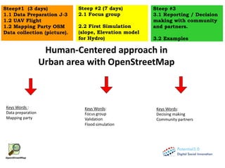
  • 1. Steep #3 3.1 Reporting / Decision making with community and partners. 3.2 Examples Steep#1 (3 days) 1.1 Data Preparation J-3 1.2 UAV Flight 1.2 Mapping Party OSM Data collection (picture). Steep #2 (7 days) 2.1 Focus group 2.2 First Simulation (slope, Elevation model for Hydro) Keys Words: Focus group Validation Flood simulation Keys Words: Decising making Community partners Keys Words : Data preparation Mapping party Human-Centered approach in Urban area with OpenStreetMap
  • 2. Collection of spatial data: Admin, Road, settlement, analysis (damage assessment, flood, etc) . Satellite image / Drone image
  • 3. for FLOOD simulation Orthophoto Digital Surface Model UAV VALIDATION Water level Discharge measurement UAV orthophoto Land cover Cleansing DSM Existing Satellite: Orthophoto, Digital Terrain Model (DTM) GIS information: Locals, Open data platform (Open Street Map) Hydro meteorological information: Precipitation, discharge
  • 4. 1.1 Data Preparation Map your environment with local the community during a mapping party. OPEN DATA is available Yes Integrate them inside OpenStreetMap Database. No
  • 5. UAV mission. Utilization steps UAV flight plan
  • 6. 3D points from 2D Keypoint matches. 3D visualisation of River Digital Surface Model points cloud High: 54 Low: 18 Elevation: UAV Digital Surface Model (DSM)
  • 7. Haiti, 3D visualisation of Canaan's zone. 1 meters contour lines UAV Digital Surface Model (DSM)
  • 8. Port Au Prince, Orthomosaic of Canaan. Rectification and fusion of Red, Green, Blue and Near infra red spectral bands. False colour visualisation UAV Orthophoto
  • 9. High: 42 Low: 25 High: 54 Low: 18 Haiti, university of Limonade. Digital Terrain Model (DTM) 10 cm resolution Elevation: Elevation: UAV Digital Surface Model (DSM)
  • 10. Haiti, Port au Prince. Google satellite orthophoto; 40cm pixel size resolution UAV orthophoto; 4 cm pixel size resolution UAV Images
  • 11. Steep #2 2.1 Community Audit . - Need Assessment - Outcomes mapping - Focus group - Problem /Solution
  • 12. Steep #2 2.1 Participatory GIS . 2 - Participatory GIS in risk reduction (Cite Soleil) with OSM platform 2.1 – Discussion with Focus group Training 2.2 – Survey with walking paper and form 2.3 – Editing JOSM ✓ Participatory mapping makes possible to update geographic information and plan interventions together
  • 13. Steep #2 2.1 Survey Canal survey in Cite Soleil for risk reduction project .
  • 14. Steep #2 2.1 Survey Road assessment using OSM plateform (per section)
  • 15. Land Use Bridges Storage areas Lateral structures Stream network …. Manning’s coefficent CN, Curve Number …. Data cleansing Hydro metereological information Precipitations Discharge measurement …. Steep #2 2.1 Data flood for simulation
  • 17. 1st Simulation Problem! Too many information 1st Hydraulic simulation
  • 19. Haiti, Martisan’s basin. Land Cover Feature Classification Feature Segmentation Feature-based image analyse
  • 20. Haiti, Martissant zone. Hydraulic simulation showing water level extent. Below, zoom in two urban zones
  • 21. Haiti, Martissant zone. Hydraulic simulation showing water speed and photos of field flood level
  • 22. RAIN SEASONDRY SEASON Haiti, Grand Goave. GIS map of hydraulic simulation showing water level during dry and rain season X [m] Z [m] X [m] Z [m] Haiti, Grand Goave. Cross-Section plot showing water level during dry and rain season RAIN SEASON XZ plot Cross-Section DRY SEASON XZ plot Cross-Section
  • 23. Haiti, Grand Goave. 3D visualisation of water flood extent and river-network Cross-Sections River cross sections. XY sections visualisation overlapped on WorldView satellite image Hec-RAS 3D visualisation of river cross section generated each 10 m river course distances
  • 24. Sensor: The non-intrusive nature (not submerged) of this solution means that it continues to function during extreme events such as flooding. Designed as a hydrometric information service it is a "4 in 1" data and measurement display system (height, velocity, discharge) making it possible to:  create and update a rating curve using a number of discharge estimates calculated by the software using the images;  obtain two discharge calculations: the discharge estimated by the current rating curve (Q) systematically, as well as the discharge estimated using the surface velocity measured (Qcalc) on an ad hoc basis;  detect changes in hydraulic behaviour (i.e. rating curve shift)
  • 26. Steep #3 3.2 Example of community decision making Cleaning of wastewater canals Soley Leve, quartier by quartier change on the ground, in Cité Soleil. Blocks organize to improve their own neighborhood. This map traces their progress,,,
  • 27. Steep #3 3.2 Example of community decision making Cleaning of wastewater canals. International community took credit for this work. Local community removed the advertising board .
  • 28. Steep #3 3.2 Example of community decision making Recycling plastic