Canal Bike Tour
•
1 gefällt mir•704 views

History/Mystery Bike Tour of the Erie and Champlain Canals in Cohoes and Waterford.

Empfohlen
Weitere ähnliche Inhalte
Was ist angesagt?
Was ist angesagt? (18)
Andere mochten auch
Andere mochten auch (20)
Ähnlich wie Canal Bike Tour
Ähnlich wie Canal Bike Tour (20)
Mehr von Mohawk Towpath Scenic Byway Coalition, Inc
Mehr von Mohawk Towpath Scenic Byway Coalition, Inc (20)
Kürzlich hochgeladen
Kürzlich hochgeladen (20)
Canal Bike Tour
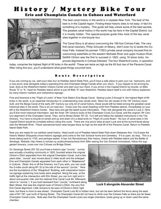
- 1. R o u t e D e s c r i p t i o n If you are coming by car, start your bike tour at Peebles Island State Park; you’ll have a safe place to park your car, restrooms, and a nice picnic area alongside today’s operating Erie and Champlain Barge Canals when you return. If you happen to be arriving by boat, dock at the Waterford Harbor Visitors Center and start your tour there. If you arrive in the Capital District by bicycle, on Bike Route “5” or “9,” head for Peebles Island which is just off Bike “9” near Waterford. Peebles Island itself is rich with history explained by many historic markers and interpretive signage. First and foremost is the “Flight of Locks” of New York State’s Erie Barge Canal. Seeing Locks 2 through 6, the highest flight of lift- locks in the world, is an essential introduction to understanding how canals work. Were the old canals of the 19th Century never built, and the Barge Canal of the early 20th Century our only bit of canal history, these would still be listed among the greatest canal historical sites in the world. This is an on-road tour. Cross over the canal (heading north from Peebles Island). Immediately on your left is the Waterford Visitors Center. Stop here and get the latest tourist information. Then ride alongside the canal to Lock 2. Here you’ll find more historical information, see the three 19th Century locks of the Champlain Cross Cut Canal, and the original 19th Cen- tury alignment of the Champlain Canal. Then, exit to Broad Street, NY 32. Turn left and follow the detailed instructions in the Trip Itinerary. You have to bicycle on-street and up and down (it’s a dead-end) on “Flight of Locks Road.” No tour of canal sites in the Capital District would be complete without riding this route. There are nice picnic sites at each Lock and at the summit-level along- side the Mohawk River. These operational locks raise barges twice as high as the total lift of the Panama Canal. Return to Peebles Island State Park. Now you are ready for our earliest canal history. Head south out of Peebles Island State Park down Delaware Ave. You’ll pass the historic Matton Shipyards (more historic signage) and come to the Van Schaick home and Cemetery. If it is open, do stop. This is a home dating back to 1735, and perhaps earlier. It has rich Revolutionary War history, linked with Peebles Island and the Battle of Saratoga. Website: http://www.ci.cohoes.ny.us/abcohoes/schaick.html After seeing the Van Schaick homestead, follow the sug- gested itinerary, cross over into Cohoes via Bridge Street. On Saratoga Street (NY 32) you’ll see a historic sign “Juncta.” Juncta was actually a bustling community in 1825, founded where the original Clinton’s Ditch separated from the original Champlain Canal. Just a few years later, “Juncta” was moved about 2 miles south and the enlarged Erie and Champlain Canals separated from each other in “Maplewood” in Colonie. (Note: this is off the Itinerary, but if you wish, you can cycle the 2-miles south along NY 32 to the site of the second “Juncta.” Here are the foundations of the “Weighlock” Building, with interpretive histori- cal signage explaining how boats were weighed. Along the way, at the traffic light at the intersection with Elm Street, you can turn right and in about one-quarter mile visit the restored Erie Canal Lock #4. Afterward, return to “Juncta.”) If you look backward from “Juncta,” northward along Main Street, that was the original route of Clinton’s Ditch, the very first Erie Canal alignment. Little remains to be seen of Clinton’s Ditch right here, but there is more to see ahead. Champlain Canal Lock #2 is hidden here, but can be seen behind the fence along the west side of NY 787, just north of Spring Street. The Champlain Canal did not have to climb over the Cohoes Falls so there are far fewer Champlain Canal Locks. Note also that the Champlain Canal Locks are single chambers; boats going up or down used the same chamber. H i s t o r y / M y s t e r y B i k e T o u r Erie and Champlain Canals in Cohoes and Waterford Lock 9 alongside Alexander Street Cohoes Falls from overlook The best canal history in the world is in Upstate New York. The best of the best is in the Capital region. Finding these historic sites is not easy; in fact it’s something of a mystery. This guide will help unlock some of the best secrets. The greatest canal history in the world may be here in the Capital District, but it is mostly hidden. This special-purpose guide links most of the key canal sites together in one bicycle tour. The Canal Story is all about overcoming the 169 foot Cohoes Falls. The very first canal visionary, Philip Schuyler of Albany, didn’t even try to tackle the Co- hoes Falls. Instead his pioneer 1700’s private canal company focused first on overcoming waterfalls on the western Mohawk River and upper Hudson River. DeWitt Clinton was the first to succeed in 1825, using 19 stone locks. Im- proved alignments in Cohoes followed. The four Waterford Locks, in operation today, comprise the highest flight of lift locks in the world! These are twice as high as the 85 foot rise of the Panama Canal. After riding this tour, you’ll understand what great things occurred here.
- 2. The recommended route will take you, next, alongside the great stone double-chamber locks of the enlarged Erie Canal. Lock 9 is directly alongside Alexander Street. SEE PHOTO ON FIRST PAGE. This Erie alignment dates from the 1840’s and continued im- provements were made at these locks throughout the 19th Century. Erie Locks 9 through 18 are in Cohoes. All but Lock #13 can still be found; some are easy to find, others are difficult. In places, there is a “canaltrail,” built atop the old towpath. Some of it is easy to follow and scenic; other parts are impossible to follow or even a bit hazardous. Read the Itinerary carefully. My recom- mended route will take you from Lock 9 to 11 and then to Locks 15 through 18. But feel free to explore local streets if finding all lock sites interests you, or, if time is short, take the Mohawk-Hudson Bikepath (built atop the Schenectady and Troy Railroad bed; one of the origi- nal 12 short railroads that made up the New York Central Railroad, in 1853) 2-miles to Lock 18. All this is explained in the Itinerary. The original canal route, Clinton’s Ditch, was not immediately abandoned. Much of it was converted into power canals for the water-powered textile mills of Cohoes. You’ll see some of these canal sites along your bike route near Olmstead Street (an historic area) and alongside Mohawk Street. Stop and read the historic signs. In 1825 Governor DeWitt Clinton “sailed” through this square aboard the Seneca Chief on his way to the “Wedding of the Waters.” Be sure to stop in at the Cohoes Visitors Center, right nearby on Remsen Street. There is so much canal history in Cohoes that a visit to the excellent interpretive information at the Cohoes Visitor’s Center is essential to understanding ex- actly what happened where and when. They offer an excellent brochure, “The Erie Canal in Cohoes;” Pick one up. It is also avail- able for download at the City of Cohoes website: http://www.ci.cohoes.ny.us/services/Canal.pdf After stopping at the Cohoes Visitors Center, next on the itinerary are Erie Locks 15-18. You have to do some biking (or walking) on grassy areas to see these awesome stone structures, but they are the best preserved of all. SEE PHOTO OF LOCK #17 ABOVE The 169 foot high Cohoes Falls was a stupendous barrier to canal builders. The overlook on School Street, just off Mohawk Street, is worth the stop. The Falls are most impressive in springtime. As the season progresses, more-and-more water is needed to be diverted to Erie Barge Canal operations, and power generation, so late in the season, you may just see bare stone. It is said that the Mohawk Indian Hiawatha got the inspiration to found the Haudenosaunee (later identified as the Five Na- tions Confederacy by the British or Iroquois by the French) after careful contemplation at this site. A good deal of information about Cohoes Falls can be ob- tained at the City of Cohoes website: http:// www.ci.cohoes.ny.us/abcohoes/falls.html. Head down Mohawk Street; you are following the origi- nal alignment of “Clinton’s Ditch.” When the Erie was enlarged and moved, the first alignment was reused as power canals to provide waterpower to the Mills you see today. At the bottom of Mohawk Street cross the railroad tracks, and turn left, with the green-arrow, northbound onto NY 32. Cross the Mohawk River on NY 32 and take the very first right onto Museum Lane, a dead-end street. Care- fully look for a wooden stairway. Get off your bike and descend the steps to the original Champlain Canal towpath. The lock you see is Champlain Canal Lock #4. SEE PHOTO. Unlike the Erie, which had two awe- some aqueducts to carry its boats over and above the Mohawk River, the Champlain’s barges were floated across the Mohawk behind a dam at this location. The dam created “slackwater,” hopefully, and Lock 3 on the south side (no remains) and Lock 4 on the north, protected and stabilized the Champlain Canal’s water levels, equalizing them with the water level of the Mohawk River. Be sure to go to the Mohawk River overlook. Then follow the cinder pathway north alongside the old Champlain Canal all the way to Erie Barge Canal Lock 2. This is a short but his- toric ride, offering some glimpses into old canal scenes. Massive stone structures of Lock 17 “Old” Champlain Canal Lock No. 4 (Route Description continued on last page)
- 3. Recommended Itinerary (See full text for more descriptive information. This is an on and off road tour. Mileage will vary depending on amount of sightseeing along the way. This tour can be taken in either direction or from other starting points. This itinerary starts and finishes at Peebles Island State Park.) How to find the most historic Erie and Champlain Canal sites of the 19th Century 0.0 miles Cross bridge heading south. Continue south on Delaware Ave (cross NY 470). 1.3 miles Stop at VanSchaick Mansion. Turn right onto Van Schaick St; left on Third Street. Turn Right on Bridge Street (cross into Cohoes, cross NY 787). Take next left onto NY 32, Saratoga Street. 1.1 miles Look for “Juncta” Historical Marker on left; look for old Champlain Lock 2. Stop. Take next right onto Spring St. Cross RR tracks carefully. Left onto Lincoln Ave. Immediate right onto Alexander Street. Look for historic Erie Lock #9 on your right. Stop. [NOTE: If you do not have the time to explore and wish to see only the best-preserved sites, then continue up Alexander to the Mohawk-Hudson BikeTrail. Take the trail thru Cohoes to Manor St (2.0 miles). Turn right onto Manor, then right onto N. Mohawk St. Look carefully for Lock 18, which is across a grassy area on your right. After visiting this impressive site, resume your tour below, and visit Cohoes Falls]. 0.2 miles At Lock #9, turn onto “canal trail” that heads north atop old Erie Canal Towpath. 0.3 miles Ride by ruins of Lock #10 to George Street; trail ends. Ruins of Lock #11 lie ahead. Turn right onto George Street then left onto Lancaster Street. The old Canal is very hard to follow here; stay on Lancaster till it ends at White St. Right onto White, quick left onto Sargent, right on Ontario, quick left on Olmstead. This Square is the site of “Clinton’s Ditch,” the first Erie Canal. STOP Cross the Square, go right onto Cayuga to Mohawk Street. [NOTE: Cohoes Visitors Center is on Remsen St on your right – An important stop.] 1.0 mile Left onto Mohawk. At light, turn left, N. Mohawk Street. Head uphill on N. Mohawk. Clinton’s Ditch sites on left. 0.2 miles Turn left on Vliet. Near next intersection, you’ll come to “canal trail.” Stop. Erie Lock #15 is in the distance on your left; Lock #16 is immediately to your right. Go right and follow Harmony and Devlin Streets which parallel the grassy “canaltrail,” or ride on the grassy trail.Locks #17 and #18 lie ahead; by road left on Erie St, right on Orchard, left on Church. 0.6 miles Stop at Lock 18. Then go over grassy area to N. Mohawk Street. Turn downhill to Cohoes. To visit Cohoes Falls overlook, go left onto School Street. Stop. Next go south on Cataract Street, right onto Front St. Left onto Mohawk Street, downhill. Descend Mohawk Street all the way to NY 32 (On your right is Clinton’s Ditch). 1.1 miles At NY 32, after RR tracks, at light, turn left with green arrow. Cross the Mohawk River. 0.3 miles Immediately upon entering Waterford take first right (Museum Lane). Follow signs to Waterford Visitors Center, but look for steps on right. Dismount. Take steps down to Champlain Canal. You are at Champlain Lock 4. Follow Champlain Canal towpath (cinder bed) north, crossing several streets. 1.1 miles Arriving at NYS Erie Barge Canal Lock #2, follow the path to South St. Cross the bridge over the Canal directly ahead (Mohawk Street/4th Street). Lock 2 Canal Park is on your left; Waterford Harbor Visitors Center on your right. Visit Erie Barge Lock #2 Canal Park, three Champlain Side Cut Canal locks, and the Waterford Visitors Center. Stop. Exit to NY 32, Broad Street. An option is to visit still more of the old Champlain Canal towpath. Look for the cinder path straight across NY 32 across from Lock 2.This is a 1.25 mile dead-end path. (2.5 miles total, off-road). In 0.2 miles you’ll come to the site of a small weighlock building, and in a further 0.9 miles to historic Champlain Lock 5. Return to NY 32 in Waterford on the old towpath. To return to Peoples Island, simply take Broad Street eastward through Waterford to 2 nd Street. Turn right, cross over the next Bridge back to starting point on Peebles Island. This is about a 10-15 mile loop. But there is more to see. How to find the historic Erie and Champlain Barge Canals of the 20th Century No tour should omit the “Flight of Locks,” the highest flight of liftlocks in the World. (approx. 2.5 mile each way, 5 miles total, all on-road). From Lock 2, turn left onto NY 32, immediately bear right. Follow 6th Street to Washington Street. Turn left onto Washington Street. Pass Lock 3 on your left. Look for “Flight of Locks Road,” on your left. Follow to top climbing alongside Locks 4, 5 and 6, and two guard gates, to the summit. Stop and sightsee. This is a dead-end road, so retrace your route back to Lock #2/NY 32 in Waterford. Also, there is Champlain Barge Canal Lock #1. (approx 2.5 miles each way, 5 total, all on-road). Follow NY 32 where it turns left (north) off Broad Street. This is NY Bike “9.” It is 2.5 miles on-road with good shoulders (NY 32/US 4/Bike 9) directly to a small park at Champlain Lock #1. This is also site where Henry Hudson’s crew turned back in 1609. You do too. Return to Waterford on the same road. Finally, there is a Federal Lock, on the Hudson River in Troy. It is fenced-off and pretty inaccessible. To return to Peebles Island, take Broad Street eastward through the village of Waterford to 2nd Street. Turn Right onto 2nd Street Try not to miss Waterford Visitors Center alongside the Barge Canal welcoming docks. Cross the Bridge and you are back at starting point on Peebles Island. This should total 15- 20-25 miles in all. Depending on the options chosen.
- 4. You’ll arrive at Erie Barge Canal Lock #2. SEE PHOTO AT RIGHT. These very much larger concrete locks of the Barge Canals were state-of-the-art technology when built almost 100 years ago. They are all contemporary with, and de- signed like those at the Panama Canal. The Champlain Cross Cut Canal is right alongside Barge Canal Lock #2, providing a great contrast in engineering technologies of the 19th and 20th Centuries. Be sure to visit the Waterford Harbor Visitors Center, which is alongside the Barge Canal between the two bridges. They have excellent interpretive information, offer directions, and can answer many questions. Here you have some choices. You can cross back over the Canal to Peebles Island and complete your tour of 19th Cen- tury Canal sites with a loop of about 10 miles. But if you want to see still more, there are still more important, historic things to see in Waterford. If you haven’t toured the “Flight of Locks,” recommended at the start, do so now. Also in Waterford is another stretch of old Champlain Canal towpath. This is a dead-end 1.25 mile cinder path. It heads directly north from Erie Barge Canal Lock #2, on the other side of NY 32. It’s pretty easy to find. You’ll be cycling atop the old towpath, pass another old Champlain Canal lock and some historical signage at the site of a small weighlock and another lock. Notice that you are cycling some 20-30 feet above the landscape. Finding a level path was another real challenge to canal builders and fre- quently watertight canal beds, like this, had to be built high above the surrounding land. As this is a dead-end, you need to cycle back to Waterford. And lastly, Champlain Barge Canal Lock 1 is 2.5 miles north of Waterford, on NY 32 / US 4, which is also Bike Route “9.” There is a small park here also. This is where, in 1609, Henry Hudson’s crew turned back down the Hudson River abandoning their quest for the Northwest Passage. But Henry Hudson had discovered one of the greatest natural waterways in the world - -the Hudson and Mohawk Rivers. These waterways had already made the Haudenosaunee, or Five Nations Confederacy possible. They would make a passageway by water – by the Erie and Champlain Canals – possible as well. There you go, after seeing the Flight of Locks and/or Champlain Canal sites, you are back in Waterford on NY 32. It’s a nice village. Stop and enjoy. Head down Broad Street, through the Village and turn right onto Second Street. Just before you cross the Mohawk River, the Waterford Harbor Visitors Center will be on your right. Finally, cross over the bridge back to Peebles Island State Park. Directions to Visitors Centers: Cohoes Visitors Center: 58 Remsen Street, Cohoes, NY Peebles Island State Park: Take NY 470 (Ontario Street) to Delaware Ave. Turn north on Delaware to Park. Waterford Harbor Visitors Center: Alongside Barge Canal, One Tugboat Alley, near 2 nd Street, Waterford, NY “Cycling Along the Canals of New York” was written by Louis Rossi, a career state-DOT engineer. A recent book review in “Mohawk Valley Heritage” magazine stated; “A cycling guidebook that reads like a novel. Directions, maps and places to stay are intertwined with rich descriptions of geological and human history. A must have for history buffs with bikes.” Available at most bookstores or through publisher: www.vitessepress.com The book is a complete guide to all the Erie, Champlain, Oswego, and Cayuga-Seneca Canals and their feeder canals. It describes more than 500 miles of cycling through New York’s canal history. Erie Barge Canal Lock No. 2 and Cross-Cut Canal