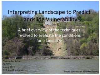
SlideShare ist ein Scribd-Unternehmen logo
1 von 35
Interpreting Landscape to Predict
          Landslide Vulnerability
               A brief overview of the techniques
              involved to evaluate the conditions
                         for a landslide


Christopher Bride
GEP635
Spring 2012
Prof. Yuri Gorokhovich                 Photo courtesy of Riverkeeper.org
Study Site: Milton, NY
Milton Landslide into the Hudson River
Slope
Profile via
 Google
  Earth
Parameters to Study
•   Slope
•   Soil type
•   Tree/vegetation cover
•   Many others outside the scope of this class
    – Hydration
    – Impermeable surface
    – Other man-made factors
GIS
• DEM files: Digital
  Elevation Model
• GIS Clearinghouse
• County boundaries
• Hudson River
  shoreline shapefile
Data acquisition
Grid enables easy
location of the tiles
needed to acquire for
this project

Also can be done by
town name.

Download, unzip, add
to map, symbolize via
“stretched value”,
“discrete colors”, or
“classify”
Digital Elevation Model
Colored to indicate elevation in feet

This is actually 4 grid tiles
Analyze slope: Geoprocess/Slope
Soil Analysis
Simplified: Dangerous types vs.
        everything else
Slope & Soil Type
Slope & Soil Type
Orthophotos: Tree/Vegetation cover
Data Acquisition
Download Ortho-index grid
Input Ortho-grid into GIS
What tile do I need?
Choose “ID” tool in ArcGIS
Select the grid position you need
Record or memorize the grid number
Find tile coordinate in list,
download/unzip, and add to map
Start combining layers
• Ulster County Orthophotos underneath Slope
  Analysis
Milton Landslide & Slope


           Landslide
                  Area
Landslide Site & Soil Type
     Glacial Deposits


        Bedrock (type “r”)
                                “other”


                             Landslide
                                    Area
Slope & Soil Type


        Landslide
               Area
Index/Model
• Landslide susceptible soils categorized into one
  class
• Landslide susceptible slopes categorized into one
  class (slopes >30 degrees)
• Vegetation coverage was not on hand, but would
  have otherwise been given a classification as well
• For now, we will look at where soil type and
  landslides overlap/intersect.
• Then use GoogleEarth or orthophotos to evaluate
  vegetation coverage.
Union of Slope and Soil
Type Layers
Need to convert slope raster into a
polygon so that a Union geoprocess
can be performed with the Soil layer
Slope Raster to Polygon
Slope Raster from DEM    Slope polygon file >30o
Union these two layers for Landslide
         susceptibility analysis
Slope polygon       Soil polygon
Soil and Slope Union
After “Union” geoprocess, the areas
with >30 degree slope that overlay the
landslide susceptible soil types are
indicated in red. All other areas, soil
and slop alike, are indicated in green.
Ulster Landslide Area Analysis
Landslide site, 2011
Final map
Potential Problem Area
Residential, tree removal apparent,
strong slope and soil type correlation
to landslide conditions.

Advice? Don’t remove the trees or
vegetation in these areas.
GoogleEarth Photo of Potential
       Landslide Area
References
• Orthophotos and Soil Data: http://gis.ny.gov/
  (NYState GIS Clearinghouse)
• Digital Elevation Models:
  http://cugir.mannlib.cornell.edu/datatheme.js
  p?id=23 (CUGIR: Cornell University Geospatial
  Information Repository)
• Opening photo:
  http://hudsonriverkeeper.blogspot.com/2012/
  04/landslide-into-wetland-at-residential.html
Thank You!

Weitere ähnliche Inhalte

Was ist angesagt?

Was ist angesagt? (20)

Map projection
Map projectionMap projection
Map projection
 
Gis Concepts 3/5
Gis Concepts 3/5Gis Concepts 3/5
Gis Concepts 3/5
 
TYBSC IT PGIS Unit III Chapter I Spatial Referencing and Positioning
TYBSC IT PGIS Unit III Chapter I Spatial Referencing and PositioningTYBSC IT PGIS Unit III Chapter I Spatial Referencing and Positioning
TYBSC IT PGIS Unit III Chapter I Spatial Referencing and Positioning
 
Chapter 6 Section 3 (maps)
Chapter 6 Section 3 (maps)Chapter 6 Section 3 (maps)
Chapter 6 Section 3 (maps)
 
Projections and coordinate system
Projections and coordinate systemProjections and coordinate system
Projections and coordinate system
 
Map Projection
Map ProjectionMap Projection
Map Projection
 
Digital Image Processing
Digital Image ProcessingDigital Image Processing
Digital Image Processing
 
Map projections
Map projectionsMap projections
Map projections
 
TYBSC IT PGIS Unit V Data Visualization
TYBSC IT PGIS Unit V  Data VisualizationTYBSC IT PGIS Unit V  Data Visualization
TYBSC IT PGIS Unit V Data Visualization
 
TYBSC IT PGIS Unit I Chapter II Geographic Information and Spacial Database
TYBSC IT PGIS Unit I Chapter II Geographic Information and Spacial DatabaseTYBSC IT PGIS Unit I Chapter II Geographic Information and Spacial Database
TYBSC IT PGIS Unit I Chapter II Geographic Information and Spacial Database
 
Themating maping
Themating mapingThemating maping
Themating maping
 
Coordinate systems, datum & map projections
Coordinate systems, datum & map projectionsCoordinate systems, datum & map projections
Coordinate systems, datum & map projections
 
Map_Projections
Map_ProjectionsMap_Projections
Map_Projections
 
Map projection
Map projectionMap projection
Map projection
 
Map Projection
Map ProjectionMap Projection
Map Projection
 
Introduction to MAPS,Coordinate System and Projection System
Introduction to MAPS,Coordinate System and Projection SystemIntroduction to MAPS,Coordinate System and Projection System
Introduction to MAPS,Coordinate System and Projection System
 
Sunu (1) kopyası kopyası (1)
Sunu (1) kopyası kopyası (1)Sunu (1) kopyası kopyası (1)
Sunu (1) kopyası kopyası (1)
 
Breakline
BreaklineBreakline
Breakline
 
georeference
georeferencegeoreference
georeference
 
Chapter 2:3 Maps
Chapter 2:3 MapsChapter 2:3 Maps
Chapter 2:3 Maps
 

Ähnlich wie Landslide Susceptibility Evaluation Techniques

Geographic information system
Geographic information systemGeographic information system
Geographic information system
Sumanta Das
 
Use of remote sensing for land cover monitoring servir science applications
Use of remote sensing for land cover monitoring servir science applicationsUse of remote sensing for land cover monitoring servir science applications
Use of remote sensing for land cover monitoring servir science applications
Kabir Uddin
 

Ähnlich wie Landslide Susceptibility Evaluation Techniques (20)

Introduction to Geographic Information system and Remote Sensing (RS)
Introduction to Geographic Information system  and Remote Sensing (RS)Introduction to Geographic Information system  and Remote Sensing (RS)
Introduction to Geographic Information system and Remote Sensing (RS)
 
soil erosion modelling by RUSLE
soil erosion modelling by RUSLEsoil erosion modelling by RUSLE
soil erosion modelling by RUSLE
 
Landuse landcover mapping
Landuse landcover mappingLanduse landcover mapping
Landuse landcover mapping
 
Site Suitability For Construction(Dam)
Site Suitability For Construction(Dam)Site Suitability For Construction(Dam)
Site Suitability For Construction(Dam)
 
Floodplain Modeling with LiDAR-Derived Terrain
Floodplain Modeling with LiDAR-Derived TerrainFloodplain Modeling with LiDAR-Derived Terrain
Floodplain Modeling with LiDAR-Derived Terrain
 
Introduction_GIS.pptx
Introduction_GIS.pptxIntroduction_GIS.pptx
Introduction_GIS.pptx
 
Site grading.pptx
Site grading.pptxSite grading.pptx
Site grading.pptx
 
study of dams
study of damsstudy of dams
study of dams
 
LiDAR Aided Decision Making
LiDAR Aided Decision MakingLiDAR Aided Decision Making
LiDAR Aided Decision Making
 
Geographic information system(GIS) and its applications in agriculture
Geographic information system(GIS) and its applications in agricultureGeographic information system(GIS) and its applications in agriculture
Geographic information system(GIS) and its applications in agriculture
 
Arc Geographic Information System (GIS) Digital Elevation Models (DEM).
Arc Geographic Information System (GIS) Digital Elevation Models (DEM).Arc Geographic Information System (GIS) Digital Elevation Models (DEM).
Arc Geographic Information System (GIS) Digital Elevation Models (DEM).
 
LANDSLIDE HAZARD ZONATION MAPPING USING RS AND GIS
LANDSLIDE HAZARD ZONATION MAPPING USING RS AND GISLANDSLIDE HAZARD ZONATION MAPPING USING RS AND GIS
LANDSLIDE HAZARD ZONATION MAPPING USING RS AND GIS
 
Introduction to DSM
Introduction to DSMIntroduction to DSM
Introduction to DSM
 
Geographic information system
Geographic information systemGeographic information system
Geographic information system
 
identification of ground water potential zones using gis and remote sensing
identification of ground water potential zones using gis and remote sensingidentification of ground water potential zones using gis and remote sensing
identification of ground water potential zones using gis and remote sensing
 
Scales and Preparation of Maps
Scales and Preparation of MapsScales and Preparation of Maps
Scales and Preparation of Maps
 
Rs and gis
Rs and gisRs and gis
Rs and gis
 
Geographic Information Systems for Food Security and Land Management in Afric...
Geographic Information Systems for Food Security and Land Management in Afric...Geographic Information Systems for Food Security and Land Management in Afric...
Geographic Information Systems for Food Security and Land Management in Afric...
 
Use of remote sensing for land cover monitoring servir science applications
Use of remote sensing for land cover monitoring servir science applicationsUse of remote sensing for land cover monitoring servir science applications
Use of remote sensing for land cover monitoring servir science applications
 
Using GIS for Civil/Environmental Projects
Using GIS for Civil/Environmental ProjectsUsing GIS for Civil/Environmental Projects
Using GIS for Civil/Environmental Projects
 

Landslide Susceptibility Evaluation Techniques