
Empfohlen
Weitere ähnliche Inhalte
Was ist angesagt?
Was ist angesagt? (20)
Ähnlich wie Map & globes
Ähnlich wie Map & globes (20)
Mehr von ashrafulislam293
Mehr von ashrafulislam293 (20)
Kürzlich hochgeladen
Kürzlich hochgeladen (20)
Map & globes
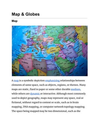
- 1. Map & Globes Map A map is a symbolic depiction emphasizing relationships between elements of some space, such as objects, regions, or themes. Many maps are static, fixed to paper or some other durable medium, while others are dynamic or interactive. Although most commonly used to depict geography, maps may represent any space, real or fictional, without regard to context or scale, such as in brain mapping, DNA mapping, or computer network topology mapping. The space being mapped may be two dimensional, such as the
- 2. surface of the earth, three dimensional, such as the interior of the earth, or even more abstract spaces of any dimension, such as arise in modeling phenomena having many independent variables. AddressBazar.com is an Bangladeshi Online Yellow Page. From here you will find important and necessary information of various Maps and Globes related Organizations in Bangladesh. Although the earliest maps known are of the heavens, geographic maps of territory have a very long tradition and exist from ancient times. The word "map" comes from the medieval Latin Mappa mundi, wherein mappa meant napkin or cloth and mundi the world. Thus, "map" became a shortened term referring to a two-dimensional representation of the surface of the world. Geographic maps Cartography or map-making is the study and practice of crafting representations of the Earth upon a flat surface (see History of cartography), and one who makes maps is called a cartographer. Road maps are perhaps the most widely used maps today, and form a subset of navigational maps, which also include aeronautical and nautical charts, railroad network maps, and hiking and bicycling maps. In terms of quantity, the largest number of drawn map sheets is probably made up by local surveys, carried out by municipalities, utilities, tax assessors, emergency services
- 3. providers, and other local agencies. Many national surveying projects have been carried out by the military, such as the British Ordnance Survey: a civilian government agency, internationally renowned for its comprehensively detailed work. In addition to location information, maps may also be used to portray contour lines indicating constant values of elevation, temperature, rainfall, etc. Orientation of maps The orientation of a map is the relationship between the directions on the map and the corresponding compass directions in reality. The word "orient" is derived from Latin oriens, meaning east. In
- 4. the Middle Ages many maps, including the T and O maps, were drawn with east at the top (meaning that the direction "up" on the map corresponds to East on the compass). The most common cartographic convention is that north is at the top of a map. Maps not oriented with north at the top: ● Maps from non-Western traditions are oriented in a variety of ways. Old maps of Edo show the Japanese imperial palace as the "top", but also at the centre of the map. Labels on the map are oriented in such a way that you cannot read them properly unless you put the imperial palace above your head. ● Medieval European T and O maps such as the Hereford Mappa Mundi were centred on Jerusalem with East at the top. Indeed, prior to the reintroduction of Ptolemy's Geography to Europe around 1400, there was no single convention in the West. Portolan charts, for example, are oriented to the shores they describe. ● Maps of cities bordering a sea are often conventionally oriented with the sea at the top. ● Route and channel maps have traditionally been oriented to the road or waterway they describe. ● Polar maps of the Arctic or Antarctic regions are conventionally centred on the pole; the direction North would be towards or away from the centre of the map, respectively. Typical maps of the Arctic have 0° meridian towards the bottom of the page; maps of the Antarctic have the 0° meridian towards the top of the page. ● Reversed maps, also known as Upside-Down maps or South-Up maps, reverse the North is up convention and have south at the top. Ancient Africans including in Ancient
- 5. Egypt utilised this orientation, as some maps in Brazil do today. ● Buckminster Fuller's Dymaxion maps are based on a projection of the Earth's sphere onto an icosahedron. The resulting triangular pieces may be arranged in any order or orientation. Scale and accuracy Many maps are drawn to a scale expressed as a ratio, such as 1:10,000, which means that 1 unit of measurement on the map corresponds to 10,000 of that same unit on the ground. The scale statement can be accurate when the region mapped is small enough for the curvature of the Earth to be neglected, such as a city map.
- 6. Mapping larger regions, where curvature cannot be ignored, requires projections to map from the curved surface of the Earth to the plane. The impossibility of flattening the sphere to the plane without distortion means that the map cannot have constant scale. Rather, on most projections the best that can be attained is accurate scale along one or two paths on the projection. Because scale differs everywhere, it can only be measured meaningfully as point scale per location. Most maps strive to keep point scale variation within narrow bounds. Although the scale statement is nominal it is usually accurate enough for most purposes unless the map covers a large fraction of the earth. At the scope of a world map, scale as a single number is practically meaningless throughout most of the map. Instead, it usually refers to the scale along the equator. Some maps, called cartograms, have the scale deliberately distorted to reflect information other than land area or distance. For example, this map (at the right) of Europe has been distorted to show population distribution, while the rough shape of the continent is still discernible. Another example of distorted scale is the famous London Underground map. The basic geographical structure is respected but the tube lines (and the River Thames) are smoothed to clarify the relationships between stations. Near the center of the map stations are spaced out more than near the edges of the map.
- 7. Further inaccuracies may be deliberate. For example, cartographers may simply omit military installations or remove features solely in order to enhance the clarity of the map. For example, a road map may not show railroads, smaller waterways or other prominent non-road objects, and even if it does, it may show them less clearly (e.g. dashed or dotted lines/outlines) than the main roads. Known as decluttering, the practice makes the subject matter that the user is interested in easier to read, usually without sacrificing overall accuracy. Software-based maps often allow the user to toggle decluttering between ON, OFF and AUTO as needed. In AUTO the degree of decluttering is adjusted as the user changes the scale being displayed. Map projection Geographic maps use a projection to translate the three-dimensional real surface of the geoid to a two-dimensional picture. Projection always distorts the surface. There are many ways to apportion the distortion, and so there are many map projections. Which projection to use depends on the purpose of the map. Globe A globe is a spherical model of Earth, of some other celestial body, or of the celestial sphere. Globes serve purposes similar to some maps, but unlike maps, do not distort the surface that they portray
- 8. except to scale it down. A model globe of Earth is called a terrestrial globe. A model globe of the celestial sphere is called a celestial globe. A globe shows details of its subject. A terrestrial globe shows landmasses and water bodies. It might show nations and major cities and the network of latitude and longitude lines. Some have raised relief to show mountains and other large landforms. A celestial globe shows notable stars, and may also show positions of other prominent astronomical objects. Typically, it will also divide the celestial sphere into constellations.
- 9. The word globe comes from the Latin word globus, meaning "sphere". Globes have a long history. The first known mention of a globe is from Strabo, describing the Globe of Crates from about 150 BC. The oldest surviving terrestrial globe is the Erdapfel, wrought by Martin Behaim in 1492. The oldest surviving celestial globe sits atop the Farnese Atlas, carved in the 2nd century Roman Empire.