SlideShare ist ein Scribd-Unternehmen logo
1 von 8
NOAA National Environmental Satellite, Data, and Information Service (NESDIS) 1
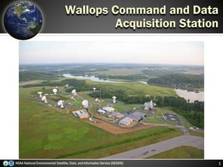
Wallops Command and Data
Acquisition Station
Three Observation Points
NOAA National Environmental Satellite, Data, and Information Service (NESDIS) 2
N
S
Polar-orbiting Operational
Environmental Satellites
Geostationary Operational
Environmental Satellites
N
S
Each satellite covers the Earth twice per day
Pole-to-pole orbit is 102 minutes and views
each location at the same time of day
Global coverage every 12 hours with one
satellite
EUMETSAT in the mid-morning orbit; NOAA in
the early afternoon orbit
Continuous monitoring of the Americas
Same geographic image over time
Full image every 30 minutes and
Northern Hemisphere images every 15
minutes
Usable images between 60oN and 60oS
Deep Space at Lagrange 1
Point
Continuous monitors the surface of the
Sun
Uninterrupted view of the sun
Located ~1 million miles from Earth,
at the Lagrange Point 1 position of
the Sun-Earth system
~1 million Miles
2011 Irene Forecast Irene “2001” Forecast
3
Building on 10+ years of
Forecast Improvement
NOAA National Environmental Satellite, Data, and Information Service (NESDIS)
4NOAA National Environmental Satellite, Data, and Information Service (NESDIS)
Deepwater Horizon
Montage of 2010 Hurricane
Season
Satellite-tagged Dolphin
DART Tsunami Buoy Coral Reef Watch
El Nino signature
Abby Sunderland
Harmful Algal Bloom
Ozone Hole
Supporting NOAA’s Mission
Snow & Ice Chart
AVHRR Composite
Stream gage
GOES SXI image
NOAA National Environmental Satellite, Data, and Information Service (NESDIS) 5
Wallops Command and Data
Acquisition Station
Station Facts
Facility dedicated on: June 22, 1966
Number of Buildings and Square Footage: 7 Buildings with 48,662 sq. ft.
Number of Antennas: 16
Workforce: 67 Civil Servant FTE
Annual Funding (NOAA Appropriations): $9.67M
NOAA National Environmental Satellite, Data, and Information Service (NESDIS) 6
Wallops Command and Data
Acquisition Station
Missions Supported
Geostationary Satellites (GOES)
Polar-Orbiting Satellites (POES; Suomi NPP)
Deep Space Climate Observatory (DSCOVR)
Advanced Composition Explorer (ACE)
Jason–2 & 3 Altimetry Satellite
COSMIC-2 Radio Occultation
Meteosat Second Generations (MSG)
Metop
Data Collection System (DCS)
GOES-R Launch Commitment Date* 1Q FY 2017
Program Architecture
4 Satellites (GOES-R, S, T & U)
10 year operational design life for each spacecraft
Program Operational Life FY 2017 – FY 2036
Program Life-cycle $10.829 billion
GOES-R Series Overview
7NOAA National Environmental Satellite, Data, and Information Service (NESDIS)
*Launch Commitment Date based on FY 2017 President’s Budget Request *
Benefits
Maintains continuity of weather observations and critical
environmental data from geostationary orbit
Provides faster scanning of entire hemisphere while
simultaneously observing individual storms, improving hurricane
tracking, aviation flight route planning, air quality warnings and
fire detection
Provides a new lightning mapping capability for improved warning
lead time for severe storms and tornadoes, allowing time to
protect lives and property
Provides improved warning of solar events to minimize impact to
communications, navigation systems, power grids and satellites
in orbit
Visual & IR Imagery Lightning Mapping Space Weather Monitoring Solar Imaging
Advanced Baseline
Imager (ABI)
Geostationary Lightning
Mapper (GLM)
Magnetometer
Extreme UV/X-Ray
Irradiance Sensors (EXIS)
Terrestrial Weather Solar Weather
Space Environment In-Situ
Suite (SEISS)
Solar Ultra-Violet Imager
(SUVI)
8
 Key for “nowcasting” out to 3 days
 Improves hurricane track & intensity
forecasts
 Increases thunderstorm & tornado
warning lead time
 Improves aviation flight route planning
 Data for long-term climate variability
studies
 Improves solar flare warnings for
communications and navigation
disruptions
 More accurate monitoring of
energetic particles responsible for
radiation hazards to humans and
spacecraft
 Better monitoring of Coronal
Mass Ejections to improve
geomagnetic storm forecasting
GOES-R Instruments
NOAA National Environmental Satellite, Data, and Information Service (NESDIS)

Weitere ähnliche Inhalte

Was ist angesagt?

Surface and soil moisture monitoring, estimations, variations, and retrievals
Surface and soil moisture monitoring, estimations, variations, and retrievalsSurface and soil moisture monitoring, estimations, variations, and retrievals
Surface and soil moisture monitoring, estimations, variations, and retrievalsJenkins Macedo
 
Surface Soil Moisture and Groundwater Assessment and Monitoring using Remote ...
Surface Soil Moisture and Groundwater Assessment and Monitoring using Remote ...Surface Soil Moisture and Groundwater Assessment and Monitoring using Remote ...
Surface Soil Moisture and Groundwater Assessment and Monitoring using Remote ...Jenkins Macedo
 
Monitoring surface deformation combining optical and radar sentinel data gsg ...
Monitoring surface deformation combining optical and radar sentinel data gsg ...Monitoring surface deformation combining optical and radar sentinel data gsg ...
Monitoring surface deformation combining optical and radar sentinel data gsg ...Pavlos Krassakis
 
What is geostationary satellite
What is geostationary satelliteWhat is geostationary satellite
What is geostationary satelliteDPSG
 
Presentation thesis
Presentation thesisPresentation thesis
Presentation thesiss1150048
 
Modification and Climate Change Analysis of surrounding Environment using Rem...
Modification and Climate Change Analysis of surrounding Environment using Rem...Modification and Climate Change Analysis of surrounding Environment using Rem...
Modification and Climate Change Analysis of surrounding Environment using Rem...iosrjce
 
Noaa satelite series
Noaa satelite seriesNoaa satelite series
Noaa satelite seriesSharp Jithan
 
Earth Observation Satellites
Earth Observation SatellitesEarth Observation Satellites
Earth Observation SatellitesDivya Basuti
 
Meterological Technology International, Nov 2010
Meterological Technology International, Nov 2010Meterological Technology International, Nov 2010
Meterological Technology International, Nov 2010laurajairam
 
Satellite Mapping
Satellite MappingSatellite Mapping
Satellite MappingPinus57
 
Rupture processes of the 2012 September 5 Mw 7.6 Nicoya CONSTRAINED
Rupture processes of the 2012 September 5 Mw 7.6 Nicoya CONSTRAINEDRupture processes of the 2012 September 5 Mw 7.6 Nicoya CONSTRAINED
Rupture processes of the 2012 September 5 Mw 7.6 Nicoya CONSTRAINEDAllan Lopez
 

Was ist angesagt? (20)

Surface and soil moisture monitoring, estimations, variations, and retrievals
Surface and soil moisture monitoring, estimations, variations, and retrievalsSurface and soil moisture monitoring, estimations, variations, and retrievals
Surface and soil moisture monitoring, estimations, variations, and retrievals
 
Satellite systems landsat 7 compatibility mode
Satellite systems landsat 7 compatibility modeSatellite systems landsat 7 compatibility mode
Satellite systems landsat 7 compatibility mode
 
Surface Soil Moisture and Groundwater Assessment and Monitoring using Remote ...
Surface Soil Moisture and Groundwater Assessment and Monitoring using Remote ...Surface Soil Moisture and Groundwater Assessment and Monitoring using Remote ...
Surface Soil Moisture and Groundwater Assessment and Monitoring using Remote ...
 
Monitoring surface deformation combining optical and radar sentinel data gsg ...
Monitoring surface deformation combining optical and radar sentinel data gsg ...Monitoring surface deformation combining optical and radar sentinel data gsg ...
Monitoring surface deformation combining optical and radar sentinel data gsg ...
 
What is geostationary satellite
What is geostationary satelliteWhat is geostationary satellite
What is geostationary satellite
 
Sat comm
Sat commSat comm
Sat comm
 
NOAA Satellite Partnerships That Matter
NOAA Satellite Partnerships That MatterNOAA Satellite Partnerships That Matter
NOAA Satellite Partnerships That Matter
 
Presentation thesis
Presentation thesisPresentation thesis
Presentation thesis
 
Modification and Climate Change Analysis of surrounding Environment using Rem...
Modification and Climate Change Analysis of surrounding Environment using Rem...Modification and Climate Change Analysis of surrounding Environment using Rem...
Modification and Climate Change Analysis of surrounding Environment using Rem...
 
AAS National Conference 2008: Graham Gibbs
AAS National Conference 2008: Graham GibbsAAS National Conference 2008: Graham Gibbs
AAS National Conference 2008: Graham Gibbs
 
Noaa satelite series
Noaa satelite seriesNoaa satelite series
Noaa satelite series
 
Earth Observation Satellites
Earth Observation SatellitesEarth Observation Satellites
Earth Observation Satellites
 
Seminar on gps
Seminar on gpsSeminar on gps
Seminar on gps
 
Global positioning system
Global positioning systemGlobal positioning system
Global positioning system
 
Meterological Technology International, Nov 2010
Meterological Technology International, Nov 2010Meterological Technology International, Nov 2010
Meterological Technology International, Nov 2010
 
DSO Thessaly report_09032021
DSO Thessaly report_09032021DSO Thessaly report_09032021
DSO Thessaly report_09032021
 
Presentation geostationary satellites (geos)
Presentation geostationary satellites (geos)Presentation geostationary satellites (geos)
Presentation geostationary satellites (geos)
 
Satellite Mapping
Satellite MappingSatellite Mapping
Satellite Mapping
 
Rupture processes of the 2012 September 5 Mw 7.6 Nicoya CONSTRAINED
Rupture processes of the 2012 September 5 Mw 7.6 Nicoya CONSTRAINEDRupture processes of the 2012 September 5 Mw 7.6 Nicoya CONSTRAINED
Rupture processes of the 2012 September 5 Mw 7.6 Nicoya CONSTRAINED
 
GeoCosmo Earthquake Forecasting
GeoCosmo Earthquake ForecastingGeoCosmo Earthquake Forecasting
GeoCosmo Earthquake Forecasting
 

Andere mochten auch

Andere mochten auch (10)

WIRA 3rd Q VA SPACE Update
WIRA 3rd Q VA SPACE UpdateWIRA 3rd Q VA SPACE Update
WIRA 3rd Q VA SPACE Update
 
Island Access - February 2015 - Wallops Island Regional Alliance
Island Access - February 2015 - Wallops Island Regional AllianceIsland Access - February 2015 - Wallops Island Regional Alliance
Island Access - February 2015 - Wallops Island Regional Alliance
 
Q1 2017 WIRA NASA Update Bill Wrobel
Q1 2017 WIRA NASA Update Bill WrobelQ1 2017 WIRA NASA Update Bill Wrobel
Q1 2017 WIRA NASA Update Bill Wrobel
 
Q1 2017 WIRA CBBT Presentation Tom Anderson
Q1 2017 WIRA CBBT Presentation Tom AndersonQ1 2017 WIRA CBBT Presentation Tom Anderson
Q1 2017 WIRA CBBT Presentation Tom Anderson
 
Q1 2017 WIRA NAVY Update CDR Jeff Lock
Q1 2017 WIRA NAVY Update CDR Jeff LockQ1 2017 WIRA NAVY Update CDR Jeff Lock
Q1 2017 WIRA NAVY Update CDR Jeff Lock
 
Virginia Economic Development - Wallops Island Regional Alliance
Virginia Economic Development - Wallops Island Regional AllianceVirginia Economic Development - Wallops Island Regional Alliance
Virginia Economic Development - Wallops Island Regional Alliance
 
WIRA 3rd Q NASA Update
WIRA 3rd Q NASA UpdateWIRA 3rd Q NASA Update
WIRA 3rd Q NASA Update
 
TCExam 12 [ENG] - Computer-Based Assessment
TCExam 12 [ENG] - Computer-Based AssessmentTCExam 12 [ENG] - Computer-Based Assessment
TCExam 12 [ENG] - Computer-Based Assessment
 
Q1 2017 WIRA VA SPACE Update Dale Nash
Q1 2017 WIRA VA SPACE Update Dale NashQ1 2017 WIRA VA SPACE Update Dale Nash
Q1 2017 WIRA VA SPACE Update Dale Nash
 
WIRA Q1 2017 Antares Update
WIRA Q1 2017 Antares UpdateWIRA Q1 2017 Antares Update
WIRA Q1 2017 Antares Update
 

Ähnlich wie Q1 2017 WIRA NOAA Update

Meteorological satellites and their types
Meteorological satellites and their typesMeteorological satellites and their types
Meteorological satellites and their typesAnnamalai University
 
Global Positioning System
Global Positioning SystemGlobal Positioning System
Global Positioning SystemIshwar Bulbule
 
NOAA and NASA Launch New Polar Satellite for Next-Gen Weather Forecasting
NOAA and NASA Launch New Polar Satellite for Next-Gen Weather ForecastingNOAA and NASA Launch New Polar Satellite for Next-Gen Weather Forecasting
NOAA and NASA Launch New Polar Satellite for Next-Gen Weather ForecastingIrene_McNeil
 
Envi sat satellite
Envi sat satelliteEnvi sat satellite
Envi sat satelliteEhsanYousaf1
 
NASA Research & Research Missions: Applications for Space Weather Forecasting
NASA Research & Research Missions: Applications for Space Weather ForecastingNASA Research & Research Missions: Applications for Space Weather Forecasting
NASA Research & Research Missions: Applications for Space Weather ForecastingAmerican Astronautical Society
 
NISAR NASA-ISRO Synthetic Aperture Radar (NISAR) Damage Mapping
NISAR NASA-ISRO Synthetic Aperture Radar (NISAR) Damage MappingNISAR NASA-ISRO Synthetic Aperture Radar (NISAR) Damage Mapping
NISAR NASA-ISRO Synthetic Aperture Radar (NISAR) Damage MappingDr. Pankaj Dhussa
 
20_CEOS_LSI-VC-2_NASAb.pptx
20_CEOS_LSI-VC-2_NASAb.pptx20_CEOS_LSI-VC-2_NASAb.pptx
20_CEOS_LSI-VC-2_NASAb.pptxSumeshSpanko
 
The Satellite applications in telecommunication
The Satellite applications in telecommunicationThe Satellite applications in telecommunication
The Satellite applications in telecommunicationnovrain7111
 
Meteorological Satellites
Meteorological SatellitesMeteorological Satellites
Meteorological SatellitesManoj Barman
 
2005-06-06 Satellite Data Us in PM Management: A Retrospective Assessment
2005-06-06 Satellite Data Us in PM Management: A Retrospective Assessment2005-06-06 Satellite Data Us in PM Management: A Retrospective Assessment
2005-06-06 Satellite Data Us in PM Management: A Retrospective AssessmentRudolf Husar
 
050405 Epa Satellite
050405 Epa Satellite050405 Epa Satellite
050405 Epa SatelliteRudolf Husar
 

Ähnlich wie Q1 2017 WIRA NOAA Update (20)

space technology
space technologyspace technology
space technology
 
Sentinel Satellites
Sentinel SatellitesSentinel Satellites
Sentinel Satellites
 
Meteorological satellites and their types
Meteorological satellites and their typesMeteorological satellites and their types
Meteorological satellites and their types
 
Microwave remote sensing
Microwave remote sensingMicrowave remote sensing
Microwave remote sensing
 
Global Positioning System
Global Positioning SystemGlobal Positioning System
Global Positioning System
 
NOAA and NASA Launch New Polar Satellite for Next-Gen Weather Forecasting
NOAA and NASA Launch New Polar Satellite for Next-Gen Weather ForecastingNOAA and NASA Launch New Polar Satellite for Next-Gen Weather Forecasting
NOAA and NASA Launch New Polar Satellite for Next-Gen Weather Forecasting
 
Envi sat satellite
Envi sat satelliteEnvi sat satellite
Envi sat satellite
 
NASA Research & Research Missions: Applications for Space Weather Forecasting
NASA Research & Research Missions: Applications for Space Weather ForecastingNASA Research & Research Missions: Applications for Space Weather Forecasting
NASA Research & Research Missions: Applications for Space Weather Forecasting
 
FINAL
FINAL FINAL
FINAL
 
NISAR NASA-ISRO Synthetic Aperture Radar (NISAR) Damage Mapping
NISAR NASA-ISRO Synthetic Aperture Radar (NISAR) Damage MappingNISAR NASA-ISRO Synthetic Aperture Radar (NISAR) Damage Mapping
NISAR NASA-ISRO Synthetic Aperture Radar (NISAR) Damage Mapping
 
Landsat.pptx
Landsat.pptxLandsat.pptx
Landsat.pptx
 
Sem 44.pptx
Sem 44.pptxSem 44.pptx
Sem 44.pptx
 
20_CEOS_LSI-VC-2_NASAb.pptx
20_CEOS_LSI-VC-2_NASAb.pptx20_CEOS_LSI-VC-2_NASAb.pptx
20_CEOS_LSI-VC-2_NASAb.pptx
 
The Satellite applications in telecommunication
The Satellite applications in telecommunicationThe Satellite applications in telecommunication
The Satellite applications in telecommunication
 
Meteorological Satellites
Meteorological SatellitesMeteorological Satellites
Meteorological Satellites
 
2005-06-06 Satellite Data Us in PM Management: A Retrospective Assessment
2005-06-06 Satellite Data Us in PM Management: A Retrospective Assessment2005-06-06 Satellite Data Us in PM Management: A Retrospective Assessment
2005-06-06 Satellite Data Us in PM Management: A Retrospective Assessment
 
050405 Epa Satellite
050405 Epa Satellite050405 Epa Satellite
050405 Epa Satellite
 
Envisat
EnvisatEnvisat
Envisat
 
AAS National Conference 2008: Gary Davis
AAS National Conference 2008: Gary DavisAAS National Conference 2008: Gary Davis
AAS National Conference 2008: Gary Davis
 
Egm 2008
Egm 2008Egm 2008
Egm 2008
 

Mehr von WallopsIslandRegionalAlliance

NASA Wallops Flight Facility, Presented by Bruce Underwood
NASA Wallops Flight Facility, Presented by Bruce UnderwoodNASA Wallops Flight Facility, Presented by Bruce Underwood
NASA Wallops Flight Facility, Presented by Bruce UnderwoodWallopsIslandRegionalAlliance
 
HRMFFA: Federal Presence in Hampton Roads: The Next 5 - 10 Yrs, Presented by ...
HRMFFA: Federal Presence in Hampton Roads: The Next 5 - 10 Yrs, Presented by ...HRMFFA: Federal Presence in Hampton Roads: The Next 5 - 10 Yrs, Presented by ...
HRMFFA: Federal Presence in Hampton Roads: The Next 5 - 10 Yrs, Presented by ...WallopsIslandRegionalAlliance
 
Nasa Langley RC Presentation: Charles Cockrell. 7.21.15
Nasa Langley RC Presentation: Charles Cockrell. 7.21.15Nasa Langley RC Presentation: Charles Cockrell. 7.21.15
Nasa Langley RC Presentation: Charles Cockrell. 7.21.15WallopsIslandRegionalAlliance
 
Goddard Space Flight Ctr. Presentation by Chris Scolese
Goddard Space Flight Ctr. Presentation by Chris ScoleseGoddard Space Flight Ctr. Presentation by Chris Scolese
Goddard Space Flight Ctr. Presentation by Chris ScoleseWallopsIslandRegionalAlliance
 
NAVSEA SCSC Command Presentation by Capt. J. P. Robinson
NAVSEA SCSC Command Presentation by Capt. J. P. RobinsonNAVSEA SCSC Command Presentation by Capt. J. P. Robinson
NAVSEA SCSC Command Presentation by Capt. J. P. RobinsonWallopsIslandRegionalAlliance
 
Wallops Research Park Phase1 Construction January 13, 2015 Wallops Island Reg...
Wallops Research Park Phase1 Construction January 13, 2015 Wallops Island Reg...Wallops Research Park Phase1 Construction January 13, 2015 Wallops Island Reg...
Wallops Research Park Phase1 Construction January 13, 2015 Wallops Island Reg...WallopsIslandRegionalAlliance
 
Virginia Economic Development, Liz Povar January 13, 2015 Wallops Island Regi...
Virginia Economic Development, Liz Povar January 13, 2015 Wallops Island Regi...Virginia Economic Development, Liz Povar January 13, 2015 Wallops Island Regi...
Virginia Economic Development, Liz Povar January 13, 2015 Wallops Island Regi...WallopsIslandRegionalAlliance
 
Virginia Space Update January 13, 2015 Wallops Island Regional Alliance
Virginia Space Update January 13, 2015 Wallops Island Regional AllianceVirginia Space Update January 13, 2015 Wallops Island Regional Alliance
Virginia Space Update January 13, 2015 Wallops Island Regional AllianceWallopsIslandRegionalAlliance
 

Mehr von WallopsIslandRegionalAlliance (18)

Q2 2017 WIRA NAVY Update Commander Jeff Lock
Q2 2017 WIRA NAVY Update Commander Jeff LockQ2 2017 WIRA NAVY Update Commander Jeff Lock
Q2 2017 WIRA NAVY Update Commander Jeff Lock
 
Q2 2017 WIRA NASA Update Bill Wrobel
Q2 2017 WIRA NASA Update Bill WrobelQ2 2017 WIRA NASA Update Bill Wrobel
Q2 2017 WIRA NASA Update Bill Wrobel
 
WIRA Update Q2 2016
WIRA Update Q2 2016WIRA Update Q2 2016
WIRA Update Q2 2016
 
Orbital ATK Update WIRA Q2 April 12 2016
Orbital ATK Update WIRA Q2 April 12 2016Orbital ATK Update WIRA Q2 April 12 2016
Orbital ATK Update WIRA Q2 April 12 2016
 
NASA Update WIRA Q2 April 12 2016
NASA Update WIRA Q2 April 12 2016NASA Update WIRA Q2 April 12 2016
NASA Update WIRA Q2 April 12 2016
 
VA SPACE Update WIRA Q2 April 12 2016
VA SPACE Update WIRA Q2 April 12 2016VA SPACE Update WIRA Q2 April 12 2016
VA SPACE Update WIRA Q2 April 12 2016
 
NAVY Update WIRA Q2 April 12 2016
NAVY Update WIRA Q2 April 12 2016NAVY Update WIRA Q2 April 12 2016
NAVY Update WIRA Q2 April 12 2016
 
NASA Wallops Flight Facility, Presented by Bruce Underwood
NASA Wallops Flight Facility, Presented by Bruce UnderwoodNASA Wallops Flight Facility, Presented by Bruce Underwood
NASA Wallops Flight Facility, Presented by Bruce Underwood
 
Antares Status, Presented by Dan Givens
Antares Status, Presented by Dan GivensAntares Status, Presented by Dan Givens
Antares Status, Presented by Dan Givens
 
MARS Update, Presented by Dale Nash
MARS Update, Presented by Dale NashMARS Update, Presented by Dale Nash
MARS Update, Presented by Dale Nash
 
HRMFFA: Federal Presence in Hampton Roads: The Next 5 - 10 Yrs, Presented by ...
HRMFFA: Federal Presence in Hampton Roads: The Next 5 - 10 Yrs, Presented by ...HRMFFA: Federal Presence in Hampton Roads: The Next 5 - 10 Yrs, Presented by ...
HRMFFA: Federal Presence in Hampton Roads: The Next 5 - 10 Yrs, Presented by ...
 
Wallops Flight Facility: Bill Wrobel. 7.21.15
Wallops Flight Facility: Bill Wrobel. 7.21.15Wallops Flight Facility: Bill Wrobel. 7.21.15
Wallops Flight Facility: Bill Wrobel. 7.21.15
 
Nasa Langley RC Presentation: Charles Cockrell. 7.21.15
Nasa Langley RC Presentation: Charles Cockrell. 7.21.15Nasa Langley RC Presentation: Charles Cockrell. 7.21.15
Nasa Langley RC Presentation: Charles Cockrell. 7.21.15
 
Goddard Space Flight Ctr. Presentation by Chris Scolese
Goddard Space Flight Ctr. Presentation by Chris ScoleseGoddard Space Flight Ctr. Presentation by Chris Scolese
Goddard Space Flight Ctr. Presentation by Chris Scolese
 
NAVSEA SCSC Command Presentation by Capt. J. P. Robinson
NAVSEA SCSC Command Presentation by Capt. J. P. RobinsonNAVSEA SCSC Command Presentation by Capt. J. P. Robinson
NAVSEA SCSC Command Presentation by Capt. J. P. Robinson
 
Wallops Research Park Phase1 Construction January 13, 2015 Wallops Island Reg...
Wallops Research Park Phase1 Construction January 13, 2015 Wallops Island Reg...Wallops Research Park Phase1 Construction January 13, 2015 Wallops Island Reg...
Wallops Research Park Phase1 Construction January 13, 2015 Wallops Island Reg...
 
Virginia Economic Development, Liz Povar January 13, 2015 Wallops Island Regi...
Virginia Economic Development, Liz Povar January 13, 2015 Wallops Island Regi...Virginia Economic Development, Liz Povar January 13, 2015 Wallops Island Regi...
Virginia Economic Development, Liz Povar January 13, 2015 Wallops Island Regi...
 
Virginia Space Update January 13, 2015 Wallops Island Regional Alliance
Virginia Space Update January 13, 2015 Wallops Island Regional AllianceVirginia Space Update January 13, 2015 Wallops Island Regional Alliance
Virginia Space Update January 13, 2015 Wallops Island Regional Alliance
 

Kürzlich hochgeladen

Factory Acceptance Test( FAT).pptx .
Factory Acceptance Test( FAT).pptx       .Factory Acceptance Test( FAT).pptx       .
Factory Acceptance Test( FAT).pptx .Poonam Aher Patil
 
Vip profile Call Girls In Lonavala 9748763073 For Genuine Sex Service At Just...
Vip profile Call Girls In Lonavala 9748763073 For Genuine Sex Service At Just...Vip profile Call Girls In Lonavala 9748763073 For Genuine Sex Service At Just...
Vip profile Call Girls In Lonavala 9748763073 For Genuine Sex Service At Just...Monika Rani
 
Module for Grade 9 for Asynchronous/Distance learning
Module for Grade 9 for Asynchronous/Distance learningModule for Grade 9 for Asynchronous/Distance learning
Module for Grade 9 for Asynchronous/Distance learninglevieagacer
 
High Profile 🔝 8250077686 📞 Call Girls Service in GTB Nagar🍑
High Profile 🔝 8250077686 📞 Call Girls Service in GTB Nagar🍑High Profile 🔝 8250077686 📞 Call Girls Service in GTB Nagar🍑
High Profile 🔝 8250077686 📞 Call Girls Service in GTB Nagar🍑Damini Dixit
 
Sector 62, Noida Call girls :8448380779 Model Escorts | 100% verified
Sector 62, Noida Call girls :8448380779 Model Escorts | 100% verifiedSector 62, Noida Call girls :8448380779 Model Escorts | 100% verified
Sector 62, Noida Call girls :8448380779 Model Escorts | 100% verifiedDelhi Call girls
 
FAIRSpectra - Enabling the FAIRification of Spectroscopy and Spectrometry
FAIRSpectra - Enabling the FAIRification of Spectroscopy and SpectrometryFAIRSpectra - Enabling the FAIRification of Spectroscopy and Spectrometry
FAIRSpectra - Enabling the FAIRification of Spectroscopy and SpectrometryAlex Henderson
 
Pulmonary drug delivery system M.pharm -2nd sem P'ceutics
Pulmonary drug delivery system M.pharm -2nd sem P'ceuticsPulmonary drug delivery system M.pharm -2nd sem P'ceutics
Pulmonary drug delivery system M.pharm -2nd sem P'ceuticssakshisoni2385
 
Connaught Place, Delhi Call girls :8448380779 Model Escorts | 100% verified
Connaught Place, Delhi Call girls :8448380779 Model Escorts | 100% verifiedConnaught Place, Delhi Call girls :8448380779 Model Escorts | 100% verified
Connaught Place, Delhi Call girls :8448380779 Model Escorts | 100% verifiedDelhi Call girls
 
Justdial Call Girls In Indirapuram, Ghaziabad, 8800357707 Escorts Service
Justdial Call Girls In Indirapuram, Ghaziabad, 8800357707 Escorts ServiceJustdial Call Girls In Indirapuram, Ghaziabad, 8800357707 Escorts Service
Justdial Call Girls In Indirapuram, Ghaziabad, 8800357707 Escorts Servicemonikaservice1
 
Forensic Biology & Its biological significance.pdf
Forensic Biology & Its biological significance.pdfForensic Biology & Its biological significance.pdf
Forensic Biology & Its biological significance.pdfrohankumarsinghrore1
 
Zoology 5th semester notes( Sumit_yadav).pdf
Zoology 5th semester notes( Sumit_yadav).pdfZoology 5th semester notes( Sumit_yadav).pdf
Zoology 5th semester notes( Sumit_yadav).pdfSumit Kumar yadav
 
Proteomics: types, protein profiling steps etc.
Proteomics: types, protein profiling steps etc.Proteomics: types, protein profiling steps etc.
Proteomics: types, protein profiling steps etc.Silpa
 
300003-World Science Day For Peace And Development.pptx
300003-World Science Day For Peace And Development.pptx300003-World Science Day For Peace And Development.pptx
300003-World Science Day For Peace And Development.pptxryanrooker
 
High Class Escorts in Hyderabad ₹7.5k Pick Up & Drop With Cash Payment 969456...
High Class Escorts in Hyderabad ₹7.5k Pick Up & Drop With Cash Payment 969456...High Class Escorts in Hyderabad ₹7.5k Pick Up & Drop With Cash Payment 969456...
High Class Escorts in Hyderabad ₹7.5k Pick Up & Drop With Cash Payment 969456...chandars293
 
❤Jammu Kashmir Call Girls 8617697112 Personal Whatsapp Number 💦✅.
❤Jammu Kashmir Call Girls 8617697112 Personal Whatsapp Number 💦✅.❤Jammu Kashmir Call Girls 8617697112 Personal Whatsapp Number 💦✅.
❤Jammu Kashmir Call Girls 8617697112 Personal Whatsapp Number 💦✅.Nitya salvi
 
chemical bonding Essentials of Physical Chemistry2.pdf
chemical bonding Essentials of Physical Chemistry2.pdfchemical bonding Essentials of Physical Chemistry2.pdf
chemical bonding Essentials of Physical Chemistry2.pdfTukamushabaBismark
 
SAMASTIPUR CALL GIRL 7857803690 LOW PRICE ESCORT SERVICE
SAMASTIPUR CALL GIRL 7857803690  LOW PRICE  ESCORT SERVICESAMASTIPUR CALL GIRL 7857803690  LOW PRICE  ESCORT SERVICE
SAMASTIPUR CALL GIRL 7857803690 LOW PRICE ESCORT SERVICEayushi9330
 
GBSN - Microbiology (Unit 2)
GBSN - Microbiology (Unit 2)GBSN - Microbiology (Unit 2)
GBSN - Microbiology (Unit 2)Areesha Ahmad
 
Molecular markers- RFLP, RAPD, AFLP, SNP etc.
Molecular markers- RFLP, RAPD, AFLP, SNP etc.Molecular markers- RFLP, RAPD, AFLP, SNP etc.
Molecular markers- RFLP, RAPD, AFLP, SNP etc.Silpa
 
Biogenic Sulfur Gases as Biosignatures on Temperate Sub-Neptune Waterworlds
Biogenic Sulfur Gases as Biosignatures on Temperate Sub-Neptune WaterworldsBiogenic Sulfur Gases as Biosignatures on Temperate Sub-Neptune Waterworlds
Biogenic Sulfur Gases as Biosignatures on Temperate Sub-Neptune WaterworldsSérgio Sacani
 

Kürzlich hochgeladen (20)

Factory Acceptance Test( FAT).pptx .
Factory Acceptance Test( FAT).pptx       .Factory Acceptance Test( FAT).pptx       .
Factory Acceptance Test( FAT).pptx .
 
Vip profile Call Girls In Lonavala 9748763073 For Genuine Sex Service At Just...
Vip profile Call Girls In Lonavala 9748763073 For Genuine Sex Service At Just...Vip profile Call Girls In Lonavala 9748763073 For Genuine Sex Service At Just...
Vip profile Call Girls In Lonavala 9748763073 For Genuine Sex Service At Just...
 
Module for Grade 9 for Asynchronous/Distance learning
Module for Grade 9 for Asynchronous/Distance learningModule for Grade 9 for Asynchronous/Distance learning
Module for Grade 9 for Asynchronous/Distance learning
 
High Profile 🔝 8250077686 📞 Call Girls Service in GTB Nagar🍑
High Profile 🔝 8250077686 📞 Call Girls Service in GTB Nagar🍑High Profile 🔝 8250077686 📞 Call Girls Service in GTB Nagar🍑
High Profile 🔝 8250077686 📞 Call Girls Service in GTB Nagar🍑
 
Sector 62, Noida Call girls :8448380779 Model Escorts | 100% verified
Sector 62, Noida Call girls :8448380779 Model Escorts | 100% verifiedSector 62, Noida Call girls :8448380779 Model Escorts | 100% verified
Sector 62, Noida Call girls :8448380779 Model Escorts | 100% verified
 
FAIRSpectra - Enabling the FAIRification of Spectroscopy and Spectrometry
FAIRSpectra - Enabling the FAIRification of Spectroscopy and SpectrometryFAIRSpectra - Enabling the FAIRification of Spectroscopy and Spectrometry
FAIRSpectra - Enabling the FAIRification of Spectroscopy and Spectrometry
 
Pulmonary drug delivery system M.pharm -2nd sem P'ceutics
Pulmonary drug delivery system M.pharm -2nd sem P'ceuticsPulmonary drug delivery system M.pharm -2nd sem P'ceutics
Pulmonary drug delivery system M.pharm -2nd sem P'ceutics
 
Connaught Place, Delhi Call girls :8448380779 Model Escorts | 100% verified
Connaught Place, Delhi Call girls :8448380779 Model Escorts | 100% verifiedConnaught Place, Delhi Call girls :8448380779 Model Escorts | 100% verified
Connaught Place, Delhi Call girls :8448380779 Model Escorts | 100% verified
 
Justdial Call Girls In Indirapuram, Ghaziabad, 8800357707 Escorts Service
Justdial Call Girls In Indirapuram, Ghaziabad, 8800357707 Escorts ServiceJustdial Call Girls In Indirapuram, Ghaziabad, 8800357707 Escorts Service
Justdial Call Girls In Indirapuram, Ghaziabad, 8800357707 Escorts Service
 
Forensic Biology & Its biological significance.pdf
Forensic Biology & Its biological significance.pdfForensic Biology & Its biological significance.pdf
Forensic Biology & Its biological significance.pdf
 
Zoology 5th semester notes( Sumit_yadav).pdf
Zoology 5th semester notes( Sumit_yadav).pdfZoology 5th semester notes( Sumit_yadav).pdf
Zoology 5th semester notes( Sumit_yadav).pdf
 
Proteomics: types, protein profiling steps etc.
Proteomics: types, protein profiling steps etc.Proteomics: types, protein profiling steps etc.
Proteomics: types, protein profiling steps etc.
 
300003-World Science Day For Peace And Development.pptx
300003-World Science Day For Peace And Development.pptx300003-World Science Day For Peace And Development.pptx
300003-World Science Day For Peace And Development.pptx
 
High Class Escorts in Hyderabad ₹7.5k Pick Up & Drop With Cash Payment 969456...
High Class Escorts in Hyderabad ₹7.5k Pick Up & Drop With Cash Payment 969456...High Class Escorts in Hyderabad ₹7.5k Pick Up & Drop With Cash Payment 969456...
High Class Escorts in Hyderabad ₹7.5k Pick Up & Drop With Cash Payment 969456...
 
❤Jammu Kashmir Call Girls 8617697112 Personal Whatsapp Number 💦✅.
❤Jammu Kashmir Call Girls 8617697112 Personal Whatsapp Number 💦✅.❤Jammu Kashmir Call Girls 8617697112 Personal Whatsapp Number 💦✅.
❤Jammu Kashmir Call Girls 8617697112 Personal Whatsapp Number 💦✅.
 
chemical bonding Essentials of Physical Chemistry2.pdf
chemical bonding Essentials of Physical Chemistry2.pdfchemical bonding Essentials of Physical Chemistry2.pdf
chemical bonding Essentials of Physical Chemistry2.pdf
 
SAMASTIPUR CALL GIRL 7857803690 LOW PRICE ESCORT SERVICE
SAMASTIPUR CALL GIRL 7857803690  LOW PRICE  ESCORT SERVICESAMASTIPUR CALL GIRL 7857803690  LOW PRICE  ESCORT SERVICE
SAMASTIPUR CALL GIRL 7857803690 LOW PRICE ESCORT SERVICE
 
GBSN - Microbiology (Unit 2)
GBSN - Microbiology (Unit 2)GBSN - Microbiology (Unit 2)
GBSN - Microbiology (Unit 2)
 
Molecular markers- RFLP, RAPD, AFLP, SNP etc.
Molecular markers- RFLP, RAPD, AFLP, SNP etc.Molecular markers- RFLP, RAPD, AFLP, SNP etc.
Molecular markers- RFLP, RAPD, AFLP, SNP etc.
 
Biogenic Sulfur Gases as Biosignatures on Temperate Sub-Neptune Waterworlds
Biogenic Sulfur Gases as Biosignatures on Temperate Sub-Neptune WaterworldsBiogenic Sulfur Gases as Biosignatures on Temperate Sub-Neptune Waterworlds
Biogenic Sulfur Gases as Biosignatures on Temperate Sub-Neptune Waterworlds
 

Q1 2017 WIRA NOAA Update

  • 1. NOAA National Environmental Satellite, Data, and Information Service (NESDIS) 1 Wallops Command and Data Acquisition Station
  • 2. Three Observation Points NOAA National Environmental Satellite, Data, and Information Service (NESDIS) 2 N S Polar-orbiting Operational Environmental Satellites Geostationary Operational Environmental Satellites N S Each satellite covers the Earth twice per day Pole-to-pole orbit is 102 minutes and views each location at the same time of day Global coverage every 12 hours with one satellite EUMETSAT in the mid-morning orbit; NOAA in the early afternoon orbit Continuous monitoring of the Americas Same geographic image over time Full image every 30 minutes and Northern Hemisphere images every 15 minutes Usable images between 60oN and 60oS Deep Space at Lagrange 1 Point Continuous monitors the surface of the Sun Uninterrupted view of the sun Located ~1 million miles from Earth, at the Lagrange Point 1 position of the Sun-Earth system ~1 million Miles
  • 3. 2011 Irene Forecast Irene “2001” Forecast 3 Building on 10+ years of Forecast Improvement NOAA National Environmental Satellite, Data, and Information Service (NESDIS)
  • 4. 4NOAA National Environmental Satellite, Data, and Information Service (NESDIS) Deepwater Horizon Montage of 2010 Hurricane Season Satellite-tagged Dolphin DART Tsunami Buoy Coral Reef Watch El Nino signature Abby Sunderland Harmful Algal Bloom Ozone Hole Supporting NOAA’s Mission Snow & Ice Chart AVHRR Composite Stream gage GOES SXI image
  • 5. NOAA National Environmental Satellite, Data, and Information Service (NESDIS) 5 Wallops Command and Data Acquisition Station Station Facts Facility dedicated on: June 22, 1966 Number of Buildings and Square Footage: 7 Buildings with 48,662 sq. ft. Number of Antennas: 16 Workforce: 67 Civil Servant FTE Annual Funding (NOAA Appropriations): $9.67M
  • 6. NOAA National Environmental Satellite, Data, and Information Service (NESDIS) 6 Wallops Command and Data Acquisition Station Missions Supported Geostationary Satellites (GOES) Polar-Orbiting Satellites (POES; Suomi NPP) Deep Space Climate Observatory (DSCOVR) Advanced Composition Explorer (ACE) Jason–2 & 3 Altimetry Satellite COSMIC-2 Radio Occultation Meteosat Second Generations (MSG) Metop Data Collection System (DCS)
  • 7. GOES-R Launch Commitment Date* 1Q FY 2017 Program Architecture 4 Satellites (GOES-R, S, T & U) 10 year operational design life for each spacecraft Program Operational Life FY 2017 – FY 2036 Program Life-cycle $10.829 billion GOES-R Series Overview 7NOAA National Environmental Satellite, Data, and Information Service (NESDIS) *Launch Commitment Date based on FY 2017 President’s Budget Request * Benefits Maintains continuity of weather observations and critical environmental data from geostationary orbit Provides faster scanning of entire hemisphere while simultaneously observing individual storms, improving hurricane tracking, aviation flight route planning, air quality warnings and fire detection Provides a new lightning mapping capability for improved warning lead time for severe storms and tornadoes, allowing time to protect lives and property Provides improved warning of solar events to minimize impact to communications, navigation systems, power grids and satellites in orbit
  • 8. Visual & IR Imagery Lightning Mapping Space Weather Monitoring Solar Imaging Advanced Baseline Imager (ABI) Geostationary Lightning Mapper (GLM) Magnetometer Extreme UV/X-Ray Irradiance Sensors (EXIS) Terrestrial Weather Solar Weather Space Environment In-Situ Suite (SEISS) Solar Ultra-Violet Imager (SUVI) 8  Key for “nowcasting” out to 3 days  Improves hurricane track & intensity forecasts  Increases thunderstorm & tornado warning lead time  Improves aviation flight route planning  Data for long-term climate variability studies  Improves solar flare warnings for communications and navigation disruptions  More accurate monitoring of energetic particles responsible for radiation hazards to humans and spacecraft  Better monitoring of Coronal Mass Ejections to improve geomagnetic storm forecasting GOES-R Instruments NOAA National Environmental Satellite, Data, and Information Service (NESDIS)

Hinweis der Redaktion

  1. Q Did Vermont take you by surprise completely? And I didn’t hear any warnings about Vermont. ADMINISTRATOR FUGATE: No, we knew they were in the area of heavy rainfall. And this is one thing that Director Bill Reed was trying to get people not to focus just on the center of circulation or on the coast. The heavy rainfall -- particularly this storm had a lot of rain ahead of it as it was moving ashore -- the concern was where we could expect rainfall. In fact, if you went back to the Hydromet Prediction Center, they were putting out forecasts of these types of measures that we could see as far as rainfall, so it was something we were expecting. But the reality is with flash flooding, much of this occurred very quickly. In fact, in many of these rivers in Vermont, they’ve already gone back down. It was just a very quick response rate from the rain, the flooding, and now we’re looking at the damages. You remember seeing the satellite how big that storm was and how close it was to the state of Florida? We would not have been able to not evacuate. But the science is that good on track. But where we know where we still have a lot of work to do is intensity forecasts -- what goes up and goes down. Remember Hurricane Charlie in Florida? It went from a category one in Cuba, crossing over, became a category four in less than 24 hours. We’ve seen a lot of these storms that the smaller storms, rapid anticipation. We also see storms that weaken. And that is an area that -- that skill we still need to work on. But based on the forecast, that's what we prepare for. http://m.whitehouse.gov/the-press-office/2011/08/29/press-briefing-press-secretary-jay-carney-and-fema-administrator-craig-f
  2. GOES-R is the Weather Sentinel Use for Hurricane, Severe Storms, Flash Floods Hemispheric views familiar with TV weathercasts Feeds weather models Fire/smoke products- air quality monitoring Sea Surface Temperature monitoring – fishing/climate Winds for aviation Solar X-ray imager – solar tracking for communications satellites, utility, CIP Search and Rescue Data Collection Systems (DCP) – using GOES E/W  Distribute via DOMSAT and NWSTG from Wallops Island