SlideShare ist ein Scribd-Unternehmen logo
1 von 2
ã2017 California Institute of Technology. Government sponsorship acknowledged.
NISAR: The NISAR-ISRO SAR Mission
Forest Management and Monitoring
Forest managers and agroforestry industry are in need of
accurate and timely data over large areas to assess forest
development and prescribe actions necessary to achieve
regeneration objectives. Increasing emphasis on
ecosystem management, escalating silvicultural (e.g.
reforestation) treatment costs, evolving computer-based
decision support tools, and demands for greater
accountability have produced significant demands for
spatial data on forest structure and productivity at
national and subnational scales globally.
Making Large Scale Stewardship
of Forest Resources a Reality
NISAR is designed to monitor global forest extent and quality and to provide
accurate and timely information on forest volume and products for sustainable
development and management of ecosystem goods and services.
A 21st
-Century Global Forest Watch
Forest ecosystems provide timber, fuel, and bioproducts and a
variety of services by sequestering carbon from the
atmosphere into the forest, purifying water and air, and
maintaining wildlife habitats. One of the greatest challenges
facing forest managers in the US and elsewhere in the world is
to maintain the health and resilience of the forest ecosystems.
This requires a coordinated effort for systematic monitoring of
forest cover, volume, and productivity, to develop techniques
and policies for improving the stock and sustainable use of
woody biomass.
Optical satellite observations as in Landsat have played a major
role in monitoring the forest cover and changes globally. But,
with the advent of modern radar techniques as in NISAR,
frequent and uninterrupted observations of forest volume can
become a reliable data and tool for forest managers to assess
forest status.
The NISAR Mission – Global Observatory of Forest Ecosystems
The NASA–ISRO Synthetic Aperture Radar (NISAR) mission, a collaboration
between the National Aeronautics and Space Administration (NASA) and the
Indian Space Research Organization (ISRO), will provide all-weather, day/night
imaging of nearly the entire land and ice masses of the Earth repeated 4-6 times
per month. NISAR’s orbiting radars will image at resolutions of 5-10 meters to
identify and track subtle movement of the Earth’s land and its sea ice, and even
provide information about what is happening below the surface. NISAR will also
provide forest volume and biomass over time and with enough detail to reveal
changes on human scales. Products are expected to be available 1-2 days after
observation, and within hours in response to disasters, providing actionable,
timely data for many applications.
Photos (clockwise): Flickr: Johan Weiland (CC BY-NC 2.0), USFS, Flickr: Neil Palmer/CIAT (CC BY-NC 2.0), NASA/GSFC
S
ã2017 California Institute of Technology. Government sponsorship acknowledged.
Cont. from front page
In the US, the Forest and Rangeland Renewable
Resources Planning Act of 1974 directed the Secretary
of Agriculture to make and keep current a
comprehensive inventory for a prospective Renewable
Resources Assessment of the forest and rangelands of
the US. These assessments were focused on analysis of
present and anticipated uses, demand for, and supply
of the renewable resources, with consideration of the
international resource situation and with a strong
emphasis of pertinent supply, demand and price
trends. With increasing threats to forest resources
from droughts, fire, and fragmentations, tracking the
forest health, biomass stock, and tangible products
such as timber has become a part of national security
both at home and globally.
Moving toward an inclusive monitoring system, which
can augment and enhance the national inventory data,
requires a departure from the past remote sensing of
only the forest cover. New active remote sensing
techniques using both lidar and radar have the
capability to measure both forest height and volume.
This high spatial resolution data on forest structure and
biomass density can be readily integrated into existing
forest inventory systems.
The upcoming NISAR mission will observe forests
weekly and collect the information needed to map
global forests and shrub lands at 25 m resolution
multiple times per year. Data products will be made
available at intervals that are commensurate with the
need of forestry organizations and industry in the U.S.
and around the world. NISAR images will provide near
global information sensitive to aboveground forest
structure, and can be converted to forest volume and
biomass once calibrated with the forest inventory data.
The measurements collected every 6 days can help
monitor forest disturbance and recovery from both
natural and human sources allowing managers to
improve forest health and products.
National Aeronautics and Space Administration For more information, visit http://nisar.jpl.nasa.gov/applications
Jet Propulsion Laboratory / California Institute of Technology / Pasadena, California / www.jpl.nasa.gov
With increased urbanization in proximity to forests, along with a
growing variety of vegetation (fuel types) from changes in the
landscape and management strategies, there is a pressing need
for accurate, cost-efficient, large scale maps of forest biomass,
fuel loads, disturbance and recovery. Emerging remote sensing
technologies can provide exactly the kind of large scale maps
needed to more accurately predict forest biomass, fuel loads, fire
risk, and fire behavior.
“The technology is now there to use radar to estimate forest fire
fuel load (e.g. branch and stem biomass). And the team
recognized that a much more efficient, accurate, and cost
effective approach to sensing forest structure and fuels—and
then mapping them—might lie at the heart of radar remote
sensing technology,” said biologist Don Despain, now retired
from the US Geological Survey in Montana, who was instrumental
in generating the fire management plans for the Yellowstone
National Park.
Shown at right is the derived forest volume from airborne radar
data (AIRSAR) data over the Yellow Stone National Park. NISAR
will provide similar measurements from a spaceborne platform to
enable monitoring changes of forest volume and fuel loads across
the park weekly.
Radar Imaging of Forest Volume and Disturbance
Yellowstone National Park
L-band airborne radar data collected over the Yellowstone National
Park in 2003 was used to develop maps of forest volume and fire fuel
load to help with park management and fire suppression for improving
the recreational resources and revenues. (Saatchi et al. 2007).

Weitere ähnliche Inhalte

Ähnlich wie NISAR NASA-ISRO Synthetic Aperture Radar (NISAR) Forest Resources

IMAGE PROCESSING AND CLUSTERING ALGORITHMS FOR FOREST COVER QUANTIFICATION
IMAGE PROCESSING AND CLUSTERING ALGORITHMS FOR FOREST COVER QUANTIFICATIONIMAGE PROCESSING AND CLUSTERING ALGORITHMS FOR FOREST COVER QUANTIFICATION
IMAGE PROCESSING AND CLUSTERING ALGORITHMS FOR FOREST COVER QUANTIFICATION
IAEME Publication
 
Small unmanned airships for remote perception
Small unmanned airships for remote perceptionSmall unmanned airships for remote perception
Small unmanned airships for remote perception
Adrian Peña
 
JesseMiller_MalcolmNichols_FireAndLULCResearchPaper.docx
JesseMiller_MalcolmNichols_FireAndLULCResearchPaper.docxJesseMiller_MalcolmNichols_FireAndLULCResearchPaper.docx
JesseMiller_MalcolmNichols_FireAndLULCResearchPaper.docx
Malcolm Nichols
 
AGU2012_SSC_LA_Eco_Poster_RRR-BB (Develop)
AGU2012_SSC_LA_Eco_Poster_RRR-BB (Develop)AGU2012_SSC_LA_Eco_Poster_RRR-BB (Develop)
AGU2012_SSC_LA_Eco_Poster_RRR-BB (Develop)
Blaise Pezold
 
Alertas Tempranas de Pérdida de Bosques tropicales en Perú usando Landsat
 Alertas Tempranas de Pérdida de Bosques tropicales en Perú usando Landsat Alertas Tempranas de Pérdida de Bosques tropicales en Perú usando Landsat
Alertas Tempranas de Pérdida de Bosques tropicales en Perú usando Landsat
Alejandro Leon
 
Designing & Managing Resilient Landscapes
Designing & Managing Resilient LandscapesDesigning & Managing Resilient Landscapes
Designing & Managing Resilient Landscapes
Erick Fernandes
 

Ähnlich wie NISAR NASA-ISRO Synthetic Aperture Radar (NISAR) Forest Resources (20)

IMAGE PROCESSING AND CLUSTERING ALGORITHMS FOR FOREST COVER QUANTIFICATION
IMAGE PROCESSING AND CLUSTERING ALGORITHMS FOR FOREST COVER QUANTIFICATIONIMAGE PROCESSING AND CLUSTERING ALGORITHMS FOR FOREST COVER QUANTIFICATION
IMAGE PROCESSING AND CLUSTERING ALGORITHMS FOR FOREST COVER QUANTIFICATION
 
Small unmanned airships for remote perception
Small unmanned airships for remote perceptionSmall unmanned airships for remote perception
Small unmanned airships for remote perception
 
GIS & RS in Forest Mapping
GIS & RS in Forest MappingGIS & RS in Forest Mapping
GIS & RS in Forest Mapping
 
Conservation of Imperiled Species in the Mekong Region: New Opportunities for...
Conservation of Imperiled Species in the Mekong Region: New Opportunities for...Conservation of Imperiled Species in the Mekong Region: New Opportunities for...
Conservation of Imperiled Species in the Mekong Region: New Opportunities for...
 
Farrington Final Draft
Farrington Final DraftFarrington Final Draft
Farrington Final Draft
 
JesseMiller_MalcolmNichols_FireAndLULCResearchPaper.docx
JesseMiller_MalcolmNichols_FireAndLULCResearchPaper.docxJesseMiller_MalcolmNichols_FireAndLULCResearchPaper.docx
JesseMiller_MalcolmNichols_FireAndLULCResearchPaper.docx
 
Mapesa Nestory notes 1
Mapesa Nestory notes 1Mapesa Nestory notes 1
Mapesa Nestory notes 1
 
Application of remote sensing in forest ecosystem
Application of remote sensing in forest ecosystemApplication of remote sensing in forest ecosystem
Application of remote sensing in forest ecosystem
 
A Water Quality Valuation Approach To Strategic Planning
A Water Quality Valuation Approach To Strategic PlanningA Water Quality Valuation Approach To Strategic Planning
A Water Quality Valuation Approach To Strategic Planning
 
Inventory and monitoring of tree resources in agroecosystems
Inventory and monitoring of tree resources in agroecosystemsInventory and monitoring of tree resources in agroecosystems
Inventory and monitoring of tree resources in agroecosystems
 
Great Lakes Restoration Initiative Remote Sensing Applications
Great Lakes Restoration Initiative Remote Sensing ApplicationsGreat Lakes Restoration Initiative Remote Sensing Applications
Great Lakes Restoration Initiative Remote Sensing Applications
 
Algorithm for detecting deforestation and forest degradation using vegetation...
Algorithm for detecting deforestation and forest degradation using vegetation...Algorithm for detecting deforestation and forest degradation using vegetation...
Algorithm for detecting deforestation and forest degradation using vegetation...
 
AGU2012_SSC_LA_Eco_Poster_RRR-BB (Develop)
AGU2012_SSC_LA_Eco_Poster_RRR-BB (Develop)AGU2012_SSC_LA_Eco_Poster_RRR-BB (Develop)
AGU2012_SSC_LA_Eco_Poster_RRR-BB (Develop)
 
Alertas Tempranas de Pérdida de Bosques tropicales en Perú usando Landsat
 Alertas Tempranas de Pérdida de Bosques tropicales en Perú usando Landsat Alertas Tempranas de Pérdida de Bosques tropicales en Perú usando Landsat
Alertas Tempranas de Pérdida de Bosques tropicales en Perú usando Landsat
 
Assessing the performance of random forest regression for estimating canopy h...
Assessing the performance of random forest regression for estimating canopy h...Assessing the performance of random forest regression for estimating canopy h...
Assessing the performance of random forest regression for estimating canopy h...
 
Online freely available remote sensed data
Online freely available remote sensed dataOnline freely available remote sensed data
Online freely available remote sensed data
 
Angela, Luis, Aileen pre proposal presentation on mangrove cover and PR Touri...
Angela, Luis, Aileen pre proposal presentation on mangrove cover and PR Touri...Angela, Luis, Aileen pre proposal presentation on mangrove cover and PR Touri...
Angela, Luis, Aileen pre proposal presentation on mangrove cover and PR Touri...
 
Remotesensing 11-00164
Remotesensing 11-00164Remotesensing 11-00164
Remotesensing 11-00164
 
Designing & Managing Resilient Landscapes
Designing & Managing Resilient LandscapesDesigning & Managing Resilient Landscapes
Designing & Managing Resilient Landscapes
 
NISAR NASA-ISRO Synthetic Aperture Radar (NISAR) Floods
NISAR NASA-ISRO Synthetic Aperture Radar (NISAR) FloodsNISAR NASA-ISRO Synthetic Aperture Radar (NISAR) Floods
NISAR NASA-ISRO Synthetic Aperture Radar (NISAR) Floods
 

Mehr von Dr. Pankaj Dhussa

Mehr von Dr. Pankaj Dhussa (20)

NASA Public Perception: Community Response to X-59 Quesst Mission: Phase 3
NASA Public Perception: Community Response to X-59 Quesst Mission: Phase 3NASA Public Perception: Community Response to X-59 Quesst Mission: Phase 3
NASA Public Perception: Community Response to X-59 Quesst Mission: Phase 3
 
NASA Overcoming the 50-Year Ban History of the Ban on Commercial Supersonic F...
NASA Overcoming the 50-Year Ban History of the Ban on Commercial Supersonic F...NASA Overcoming the 50-Year Ban History of the Ban on Commercial Supersonic F...
NASA Overcoming the 50-Year Ban History of the Ban on Commercial Supersonic F...
 
NASA Flight Demonstration and Capabilities Quesst Phase 3 Flight Operations
NASA Flight Demonstration and Capabilities Quesst Phase 3 Flight OperationsNASA Flight Demonstration and Capabilities Quesst Phase 3 Flight Operations
NASA Flight Demonstration and Capabilities Quesst Phase 3 Flight Operations
 
NASA Carbon Fiber Composites (CFC) Recycling Technology Enabled by the TuFF T...
NASA Carbon Fiber Composites (CFC) Recycling Technology Enabled by the TuFF T...NASA Carbon Fiber Composites (CFC) Recycling Technology Enabled by the TuFF T...
NASA Carbon Fiber Composites (CFC) Recycling Technology Enabled by the TuFF T...
 
NASA Urban Air Mobility Fatigue Prediction Aaron Crawford – NASA ULI Innovati...
NASA Urban Air Mobility Fatigue Prediction Aaron Crawford – NASA ULI Innovati...NASA Urban Air Mobility Fatigue Prediction Aaron Crawford – NASA ULI Innovati...
NASA Urban Air Mobility Fatigue Prediction Aaron Crawford – NASA ULI Innovati...
 
NASA Automated Repair Approaches for AAM
NASA Automated Repair Approaches for AAMNASA Automated Repair Approaches for AAM
NASA Automated Repair Approaches for AAM
 
NASA Multiscale Analysis Tool (NASMAT) Robust, Integrated, Physics-based, Non...
NASA Multiscale Analysis Tool (NASMAT) Robust, Integrated, Physics-based, Non...NASA Multiscale Analysis Tool (NASMAT) Robust, Integrated, Physics-based, Non...
NASA Multiscale Analysis Tool (NASMAT) Robust, Integrated, Physics-based, Non...
 
NASA Materials Informatics Enables Rapid Materials Discovery
NASA Materials Informatics Enables Rapid Materials DiscoveryNASA Materials Informatics Enables Rapid Materials Discovery
NASA Materials Informatics Enables Rapid Materials Discovery
 
NASA CFD Vision 2030: The Power of Exascale Computing
NASA CFD Vision 2030: The Power of Exascale ComputingNASA CFD Vision 2030: The Power of Exascale Computing
NASA CFD Vision 2030: The Power of Exascale Computing
 
NASA High Lift Common Research Model (CRM-HL) Ecosystem
NASA High Lift Common Research Model (CRM-HL) EcosystemNASA High Lift Common Research Model (CRM-HL) Ecosystem
NASA High Lift Common Research Model (CRM-HL) Ecosystem
 
NASA Aviary Open-source software tool for optimizing next-generation aircraft...
NASA Aviary Open-source software tool for optimizing next-generation aircraft...NASA Aviary Open-source software tool for optimizing next-generation aircraft...
NASA Aviary Open-source software tool for optimizing next-generation aircraft...
 
NASA Aircraft Certification by Analysis (CbA) 20-year Vision for Virtual Flig...
NASA Aircraft Certification by Analysis (CbA) 20-year Vision for Virtual Flig...NASA Aircraft Certification by Analysis (CbA) 20-year Vision for Virtual Flig...
NASA Aircraft Certification by Analysis (CbA) 20-year Vision for Virtual Flig...
 
NASA Self-Aligned Focusing Schlieren (SAFS) Flow Visualization Technique
NASA Self-Aligned Focusing Schlieren (SAFS) Flow Visualization TechniqueNASA Self-Aligned Focusing Schlieren (SAFS) Flow Visualization Technique
NASA Self-Aligned Focusing Schlieren (SAFS) Flow Visualization Technique
 
NASA DECO CAS Research into a New Operating Mode for Digitally Enabled Cooper...
NASA DECO CAS Research into a New Operating Mode for Digitally Enabled Cooper...NASA DECO CAS Research into a New Operating Mode for Digitally Enabled Cooper...
NASA DECO CAS Research into a New Operating Mode for Digitally Enabled Cooper...
 
NASA Advanced Exploration of Reliable Operation at low Altitudes: meteorology...
NASA Advanced Exploration of Reliable Operation at low Altitudes: meteorology...NASA Advanced Exploration of Reliable Operation at low Altitudes: meteorology...
NASA Advanced Exploration of Reliable Operation at low Altitudes: meteorology...
 
NASA Self-Adaptation of Loosely Coupled Systems across a System of Small Uncr...
NASA Self-Adaptation of Loosely Coupled Systems across a System of Small Uncr...NASA Self-Adaptation of Loosely Coupled Systems across a System of Small Uncr...
NASA Self-Adaptation of Loosely Coupled Systems across a System of Small Uncr...
 
NASA Safety Case Approach for Automated Flight Authorization System
NASA Safety Case Approach for Automated Flight Authorization SystemNASA Safety Case Approach for Automated Flight Authorization System
NASA Safety Case Approach for Automated Flight Authorization System
 
NASA RealWindDroneSim (RWDS) Enhancing Simulation Fidelity of small Uncrewed ...
NASA RealWindDroneSim (RWDS) Enhancing Simulation Fidelity of small Uncrewed ...NASA RealWindDroneSim (RWDS) Enhancing Simulation Fidelity of small Uncrewed ...
NASA RealWindDroneSim (RWDS) Enhancing Simulation Fidelity of small Uncrewed ...
 
NASA ARMD Test Data Portal (ATDP) Agile Development Method Introduction of an...
NASA ARMD Test Data Portal (ATDP) Agile Development Method Introduction of an...NASA ARMD Test Data Portal (ATDP) Agile Development Method Introduction of an...
NASA ARMD Test Data Portal (ATDP) Agile Development Method Introduction of an...
 
NASA ARMD Test Data Portal (ATDP) he ARMD Test Data Portal (ATDP) is a secure...
NASA ARMD Test Data Portal (ATDP) he ARMD Test Data Portal (ATDP) is a secure...NASA ARMD Test Data Portal (ATDP) he ARMD Test Data Portal (ATDP) is a secure...
NASA ARMD Test Data Portal (ATDP) he ARMD Test Data Portal (ATDP) is a secure...
 

Kürzlich hochgeladen

Cloud Frontiers: A Deep Dive into Serverless Spatial Data and FME
Cloud Frontiers:  A Deep Dive into Serverless Spatial Data and FMECloud Frontiers:  A Deep Dive into Serverless Spatial Data and FME
Cloud Frontiers: A Deep Dive into Serverless Spatial Data and FME
Safe Software
 
Finding Java's Hidden Performance Traps @ DevoxxUK 2024
Finding Java's Hidden Performance Traps @ DevoxxUK 2024Finding Java's Hidden Performance Traps @ DevoxxUK 2024
Finding Java's Hidden Performance Traps @ DevoxxUK 2024
Victor Rentea
 

Kürzlich hochgeladen (20)

Apidays New York 2024 - The value of a flexible API Management solution for O...
Apidays New York 2024 - The value of a flexible API Management solution for O...Apidays New York 2024 - The value of a flexible API Management solution for O...
Apidays New York 2024 - The value of a flexible API Management solution for O...
 
2024: Domino Containers - The Next Step. News from the Domino Container commu...
2024: Domino Containers - The Next Step. News from the Domino Container commu...2024: Domino Containers - The Next Step. News from the Domino Container commu...
2024: Domino Containers - The Next Step. News from the Domino Container commu...
 
Repurposing LNG terminals for Hydrogen Ammonia: Feasibility and Cost Saving
Repurposing LNG terminals for Hydrogen Ammonia: Feasibility and Cost SavingRepurposing LNG terminals for Hydrogen Ammonia: Feasibility and Cost Saving
Repurposing LNG terminals for Hydrogen Ammonia: Feasibility and Cost Saving
 
Ransomware_Q4_2023. The report. [EN].pdf
Ransomware_Q4_2023. The report. [EN].pdfRansomware_Q4_2023. The report. [EN].pdf
Ransomware_Q4_2023. The report. [EN].pdf
 
MS Copilot expands with MS Graph connectors
MS Copilot expands with MS Graph connectorsMS Copilot expands with MS Graph connectors
MS Copilot expands with MS Graph connectors
 
ProductAnonymous-April2024-WinProductDiscovery-MelissaKlemke
ProductAnonymous-April2024-WinProductDiscovery-MelissaKlemkeProductAnonymous-April2024-WinProductDiscovery-MelissaKlemke
ProductAnonymous-April2024-WinProductDiscovery-MelissaKlemke
 
Spring Boot vs Quarkus the ultimate battle - DevoxxUK
Spring Boot vs Quarkus the ultimate battle - DevoxxUKSpring Boot vs Quarkus the ultimate battle - DevoxxUK
Spring Boot vs Quarkus the ultimate battle - DevoxxUK
 
Apidays New York 2024 - Accelerating FinTech Innovation by Vasa Krishnan, Fin...
Apidays New York 2024 - Accelerating FinTech Innovation by Vasa Krishnan, Fin...Apidays New York 2024 - Accelerating FinTech Innovation by Vasa Krishnan, Fin...
Apidays New York 2024 - Accelerating FinTech Innovation by Vasa Krishnan, Fin...
 
AXA XL - Insurer Innovation Award Americas 2024
AXA XL - Insurer Innovation Award Americas 2024AXA XL - Insurer Innovation Award Americas 2024
AXA XL - Insurer Innovation Award Americas 2024
 
Artificial Intelligence Chap.5 : Uncertainty
Artificial Intelligence Chap.5 : UncertaintyArtificial Intelligence Chap.5 : Uncertainty
Artificial Intelligence Chap.5 : Uncertainty
 
MINDCTI Revenue Release Quarter One 2024
MINDCTI Revenue Release Quarter One 2024MINDCTI Revenue Release Quarter One 2024
MINDCTI Revenue Release Quarter One 2024
 
Apidays New York 2024 - APIs in 2030: The Risk of Technological Sleepwalk by ...
Apidays New York 2024 - APIs in 2030: The Risk of Technological Sleepwalk by ...Apidays New York 2024 - APIs in 2030: The Risk of Technological Sleepwalk by ...
Apidays New York 2024 - APIs in 2030: The Risk of Technological Sleepwalk by ...
 
TrustArc Webinar - Unlock the Power of AI-Driven Data Discovery
TrustArc Webinar - Unlock the Power of AI-Driven Data DiscoveryTrustArc Webinar - Unlock the Power of AI-Driven Data Discovery
TrustArc Webinar - Unlock the Power of AI-Driven Data Discovery
 
Navigating the Deluge_ Dubai Floods and the Resilience of Dubai International...
Navigating the Deluge_ Dubai Floods and the Resilience of Dubai International...Navigating the Deluge_ Dubai Floods and the Resilience of Dubai International...
Navigating the Deluge_ Dubai Floods and the Resilience of Dubai International...
 
Cloud Frontiers: A Deep Dive into Serverless Spatial Data and FME
Cloud Frontiers:  A Deep Dive into Serverless Spatial Data and FMECloud Frontiers:  A Deep Dive into Serverless Spatial Data and FME
Cloud Frontiers: A Deep Dive into Serverless Spatial Data and FME
 
Rising Above_ Dubai Floods and the Fortitude of Dubai International Airport.pdf
Rising Above_ Dubai Floods and the Fortitude of Dubai International Airport.pdfRising Above_ Dubai Floods and the Fortitude of Dubai International Airport.pdf
Rising Above_ Dubai Floods and the Fortitude of Dubai International Airport.pdf
 
Polkadot JAM Slides - Token2049 - By Dr. Gavin Wood
Polkadot JAM Slides - Token2049 - By Dr. Gavin WoodPolkadot JAM Slides - Token2049 - By Dr. Gavin Wood
Polkadot JAM Slides - Token2049 - By Dr. Gavin Wood
 
Finding Java's Hidden Performance Traps @ DevoxxUK 2024
Finding Java's Hidden Performance Traps @ DevoxxUK 2024Finding Java's Hidden Performance Traps @ DevoxxUK 2024
Finding Java's Hidden Performance Traps @ DevoxxUK 2024
 
"I see eyes in my soup": How Delivery Hero implemented the safety system for ...
"I see eyes in my soup": How Delivery Hero implemented the safety system for ..."I see eyes in my soup": How Delivery Hero implemented the safety system for ...
"I see eyes in my soup": How Delivery Hero implemented the safety system for ...
 
Axa Assurance Maroc - Insurer Innovation Award 2024
Axa Assurance Maroc - Insurer Innovation Award 2024Axa Assurance Maroc - Insurer Innovation Award 2024
Axa Assurance Maroc - Insurer Innovation Award 2024
 

NISAR NASA-ISRO Synthetic Aperture Radar (NISAR) Forest Resources

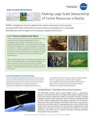
  • 1. ã2017 California Institute of Technology. Government sponsorship acknowledged. NISAR: The NISAR-ISRO SAR Mission Forest Management and Monitoring Forest managers and agroforestry industry are in need of accurate and timely data over large areas to assess forest development and prescribe actions necessary to achieve regeneration objectives. Increasing emphasis on ecosystem management, escalating silvicultural (e.g. reforestation) treatment costs, evolving computer-based decision support tools, and demands for greater accountability have produced significant demands for spatial data on forest structure and productivity at national and subnational scales globally. Making Large Scale Stewardship of Forest Resources a Reality NISAR is designed to monitor global forest extent and quality and to provide accurate and timely information on forest volume and products for sustainable development and management of ecosystem goods and services. A 21st -Century Global Forest Watch Forest ecosystems provide timber, fuel, and bioproducts and a variety of services by sequestering carbon from the atmosphere into the forest, purifying water and air, and maintaining wildlife habitats. One of the greatest challenges facing forest managers in the US and elsewhere in the world is to maintain the health and resilience of the forest ecosystems. This requires a coordinated effort for systematic monitoring of forest cover, volume, and productivity, to develop techniques and policies for improving the stock and sustainable use of woody biomass. Optical satellite observations as in Landsat have played a major role in monitoring the forest cover and changes globally. But, with the advent of modern radar techniques as in NISAR, frequent and uninterrupted observations of forest volume can become a reliable data and tool for forest managers to assess forest status. The NISAR Mission – Global Observatory of Forest Ecosystems The NASA–ISRO Synthetic Aperture Radar (NISAR) mission, a collaboration between the National Aeronautics and Space Administration (NASA) and the Indian Space Research Organization (ISRO), will provide all-weather, day/night imaging of nearly the entire land and ice masses of the Earth repeated 4-6 times per month. NISAR’s orbiting radars will image at resolutions of 5-10 meters to identify and track subtle movement of the Earth’s land and its sea ice, and even provide information about what is happening below the surface. NISAR will also provide forest volume and biomass over time and with enough detail to reveal changes on human scales. Products are expected to be available 1-2 days after observation, and within hours in response to disasters, providing actionable, timely data for many applications. Photos (clockwise): Flickr: Johan Weiland (CC BY-NC 2.0), USFS, Flickr: Neil Palmer/CIAT (CC BY-NC 2.0), NASA/GSFC S
  • 2. ã2017 California Institute of Technology. Government sponsorship acknowledged. Cont. from front page In the US, the Forest and Rangeland Renewable Resources Planning Act of 1974 directed the Secretary of Agriculture to make and keep current a comprehensive inventory for a prospective Renewable Resources Assessment of the forest and rangelands of the US. These assessments were focused on analysis of present and anticipated uses, demand for, and supply of the renewable resources, with consideration of the international resource situation and with a strong emphasis of pertinent supply, demand and price trends. With increasing threats to forest resources from droughts, fire, and fragmentations, tracking the forest health, biomass stock, and tangible products such as timber has become a part of national security both at home and globally. Moving toward an inclusive monitoring system, which can augment and enhance the national inventory data, requires a departure from the past remote sensing of only the forest cover. New active remote sensing techniques using both lidar and radar have the capability to measure both forest height and volume. This high spatial resolution data on forest structure and biomass density can be readily integrated into existing forest inventory systems. The upcoming NISAR mission will observe forests weekly and collect the information needed to map global forests and shrub lands at 25 m resolution multiple times per year. Data products will be made available at intervals that are commensurate with the need of forestry organizations and industry in the U.S. and around the world. NISAR images will provide near global information sensitive to aboveground forest structure, and can be converted to forest volume and biomass once calibrated with the forest inventory data. The measurements collected every 6 days can help monitor forest disturbance and recovery from both natural and human sources allowing managers to improve forest health and products. National Aeronautics and Space Administration For more information, visit http://nisar.jpl.nasa.gov/applications Jet Propulsion Laboratory / California Institute of Technology / Pasadena, California / www.jpl.nasa.gov With increased urbanization in proximity to forests, along with a growing variety of vegetation (fuel types) from changes in the landscape and management strategies, there is a pressing need for accurate, cost-efficient, large scale maps of forest biomass, fuel loads, disturbance and recovery. Emerging remote sensing technologies can provide exactly the kind of large scale maps needed to more accurately predict forest biomass, fuel loads, fire risk, and fire behavior. “The technology is now there to use radar to estimate forest fire fuel load (e.g. branch and stem biomass). And the team recognized that a much more efficient, accurate, and cost effective approach to sensing forest structure and fuels—and then mapping them—might lie at the heart of radar remote sensing technology,” said biologist Don Despain, now retired from the US Geological Survey in Montana, who was instrumental in generating the fire management plans for the Yellowstone National Park. Shown at right is the derived forest volume from airborne radar data (AIRSAR) data over the Yellow Stone National Park. NISAR will provide similar measurements from a spaceborne platform to enable monitoring changes of forest volume and fuel loads across the park weekly. Radar Imaging of Forest Volume and Disturbance Yellowstone National Park L-band airborne radar data collected over the Yellowstone National Park in 2003 was used to develop maps of forest volume and fire fuel load to help with park management and fire suppression for improving the recreational resources and revenues. (Saatchi et al. 2007).