
Empfohlen
Weitere ähnliche Inhalte
Ähnlich wie NostalgicOutdoors™- Grand Teton National Park- PARK MAP
Ähnlich wie NostalgicOutdoors™- Grand Teton National Park- PARK MAP (20)
Mehr von NostalgicOutdoors™
Mehr von NostalgicOutdoors™ (20)
Kürzlich hochgeladen
Kürzlich hochgeladen (20)
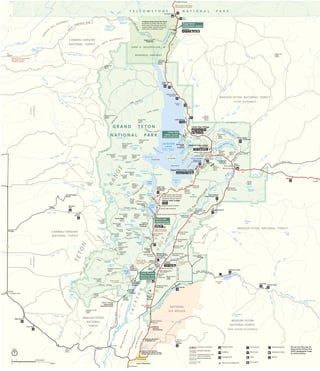
NostalgicOutdoors™- Grand Teton National Park- PARK MAP
- 1. 33 33 22 22 89 26 89 191 26 89 191 26 287 191 287 Aerial Tramway G R A N D T E T O N N AT I O N A L PA R K Y E L L O W S T O N E N A T I O N A L P A R K JOHN D. ROCKEF ELLER, JR. MEMORIAL PARKWAY Park Boundary Park Boundary Campground Food service Picnic area Marina Lodging Ranger station Self-guiding trail Store Tent-only campground Gas station Horseback riding Do not use this map for backcountry hiking. Buy USGS topographic maps at visitor centers. Trail Turnout or overlook Multi-Use Pathway Unpaved road (4-wheel drive recommended) Distance indicator5 mi 8 km 16mi 26km 8mi 13km 5mi 8km 2mi 3km 18mi 29km 12mi 19km 8mi 13km 8mi 13km Jackson Lake Junction Moran Junction North Jenny Lake Junction South Jenny Lake Junction Moose Junction Gros Ventre Junction Te t o n P a r k R o a d one-w ay Teton Park Road Closed in winter Road closed in winter Road closed to trucks, RVs, and trailers Road not recommended for trailers or RVs. Closed in winter Road closed from early November to mid-May Roads closed in winter Lower Slide Lake CrystalCreek G ros Ventre River Slate Creek Dallas Fork Upper Slide Lake Leidy Lake Fox Creek Darby Creek Moose Creek CoalCreek Fish Creek Flat Creek Lake Creek South Leigh Creek South Leigh Lakes Schoolroom Glacier Sunset Lake Snowdrift Lake Rimrock Lake Marion Lake Moose Lake Teton Glacier JENNY LAKE LEIGH LAKE Petersen Glacier Mica Lake Mink Lake Lake Solitude Basin Lakes Teton Creek South Bitch Creek Grizzly Creek Conant Creek Coyote Creek South Boone Creek Co ulter Creek Bailey Creek Arizona Creek Pilgrim C reek P ilgrim Creek Moose Creek Pa cific Creek Lava Creek D itch Creek North Fork M id dle F ork CottonwoodCreek Buffalo Fork Spread Creek East Fork Pilgrim Creek TWO OCEAN LAKE EM M A MATILDA LAKE C olter Bay N orth M oran Bay Moran Bay Ha lf M oon Bay Falls River Snake River Snake Rive r Snake Ri ver GrosVentre River Falls River Glade Cree k Berry Creek Owl Creek North Bitch Creek Lake of the Woods Grassy Lake Reservoir Indian Lake Arizona Lake Spalding Bay Christian Pond Elk Ranch Reservoir Heron Pond Toppings Lakes Blue Miner Lake Swan Lake Talus Lake Dudley Lake Cygnet Pond North Moran Creek Moran Creek Taggart Lake Phelps Lake Bradley Lake Surprise Lake Amphitheater Lake Hidden Falls Grizzly Bear Lake Bearpaw LakeFalling Ice Glacier Cirque Lake Skillet Glacier Triple Glaciers Trapper Lake Holly Lake String Lake Cascade Creek J A C K S O N L A K E Surface elevation 6772 ft 2064 m South Badger Creek North Leigh Creek IDAHO WYOMING IDAHO WYOMING Teton Crest Trail Alaska Bas inTrail CARIBOU-TARGHEE NATIONAL FOREST BRIDGER-TETON NATIONAL FOREST GROS VENTRE WILDERNESS BRIDGER-TETON NATIONAL FOREST TETON WILDERNESS CARIBOU-TARGHEE NATIONAL FOREST WINEG AR HOLE WILDERNESS BRIDGER-TETON NATIONAL FOREST NATIONAL ELK REFUGE JEDEDIAHSMITH W ILDERN ES S BRIDGER-TETON NATIONAL FOREST JED E D IAH SMITH WILDERNESS JACKSON HO LE TETON RANGE Jenny Lake Overlook Cascade Canyon Turnout Mountain View Turnout Potholes Turnout Mount Moran Turnout Cathedral Group Turnout Elk Ranch Flats Turnout Snake River Overlook Teton Glacier Turnout Blacktail Ponds Overlook Glacier View Turnout Teton Point Turnout Albright View Overlook Sleeping Indian Overlook Park Entrance Turnout Willow Flats Overlook Jackson Lake Overlook Oxbow Bend Turnout Windy Point Turnout Moran Entrance South Entrance Granite Canyon Entrance Moose Entrance Uhl Hill 7443ft 2268m Lozier Hill 7655ft 2333m Thor Peak 12028ft 3666m Mount Moran 12605ft 3842m Raynolds Peak 10910ft 3324m Traverse Peak 11051ft 3368m Pilgrim Mountain 8274ft 2522m Arizona Island Leeks Marina Table Mountain 11106ft 3385m 10450ft 3185m Rendezvous Peak 10927ft 3330m Ranger Peak 11355ft 3461m Teton Pass 8431ft 2570m Pinyon Peak 9705ft 2958m Moose Mountain 10054ft 3064m Buck Mountain 11938ft 3639m Mount Wister 11490ft 3502m Rockchuck Peak 11144ft 3396mMount St John 11430ft 3484m Teewinot Mountain 12325ft 3756m Mount Woodring 11590ft 3532m Inspiration Point Nez Perce 11901ft 3627m Cloudveil Dome South Teton 12514ft 3814m Mount Hunt 10783ft 3286m Teton Village Jackson Hole Mountain Resort Mount Owen 12928ft 3940m Grand Teton 13770ft 4197m Middle Teton 12804ft 3902m Blacktail Butte 7688ft 2343m Kelly Rolling Thunder Mountain 10908ft 3325m Bivouac Peak 10825ft 3299m Eagles Rest Peak 11258ft 3431m Signal Mountain 7727ft 2355m WILLOW FLATS Jackson Lake Dam Marie Island Survey Peak 9277ft 2827m Steamboat Mountain 7872ft 2399m Red Hills Atherton Creek Camping along Grassy Lake Road Fourteen primitive sites are free; first-come, first-served; and have a picnic table, metal fire ring, pit toilet, but no potable water. Teton Canyon Trail Creek Curtis Canyon Grand Targhee Resort To Dubois Hatchet Gros Ventre Gros Ventre Slide Crystal Creek Driggs Victor Wilson To Idaho Falls To Ashton To Pinedale JACKSON GRANITE BASIN M O O SE BASIN To West Thumb Trailhead Death Canyon Trailhead Granite Canyon Trailhead Laurance S. Rockefeller Preserve Jackson Hole Airport Menors Ferry Historic District Chapel of the Transfiguration Taggart Lake Trailhead Jenny Lake Lodge Chapel of the Sacred Heart Signal Mountain Lodge Leigh and String Lakes Trailheads Two Ocean Lake Trailhead Glade Creek Trailhead Hermitage Point Trailhead Climbers Ranch Lupine Meadows Trailhead Teton Science Schools Jackson National Fish Hatchery Jackson Hole Greater Yellowstone Visitor Center Refuge sleigh rides (winter only) Snow King Resort National Museum of Wildlife Art Lizard Creek PH ILLIPS RID G E W ESTGROSVENTREBUTTE EASTGROSVENTRE BUTTE M oos e-WilsonRoad Colter Bay Village Jackson Lake Lodge Medical Clinic ELK ISLAND Grassy Island H e rm itage Point D onoho Pt WEBB CANYON MORAN CANYON LEIGH CANYON PAINTBRUSH CAN YON COLTER CANYON W ATERFALLS CANYON Buffalo Valley Road P acific C reek Road R iver Road (4-wheel -driv e required) RiverRoad Antelope Flats Rd A NTELOPE FLATS SHADO W M OUNTAIN MormonRow Cunningham Cabin Historic Site Triangle X Ranch Dornans Deadmans Bar Road Cattleman’s Bridge Site River access River access River access THE POTHOLES AVALANCHE CANYON DEATH CANYON GRANITE CANYON OPEN CANYON GARNET CANYON HANGING CANY ON Shu ttle boat CASCADE CANYON Schwabacher Road Park Headquarters River access Gros Ventre Roa d Signal Moun ta in Rd Grand View Point 7586ft 2312m Mike Harris Reunion Flat A shton - Flagg Ranch Road Grass y Lake Road Static Peak 11303ft 3445m Prospectors Mountain 11241ft 3426m Murie Ranch Jenny Lake Trailhead 6467ft 1971m Boat launch River access River access River access River access ALASKA B ASIN Flagg Ranch Information Station Colter Bay Visitor Center Indian Arts Museum Jenny Lake Visitor Center Craig Thomas Discovery and Visitor Center North 0 1 0 1 5 Miles 5 Kilometers