
Empfohlen
Empfohlen
Weitere ähnliche Inhalte
Was ist angesagt?
Was ist angesagt? (19)
Ähnlich wie Geotechnics
Ähnlich wie Geotechnics (20)
Kürzlich hochgeladen
Kürzlich hochgeladen (20)
Geotechnics
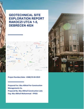
- 1. 1 Project Number/date: 6588/19-04-2019 Prepared For: Abu-Alkhail For Construction Managements Co. Prepared By: Abu-Alkhail Construction Labs Eng: Abu-Alkhail Mohammad - FPIIDJ GEOTECHNICAL SITE EXPLORATION REPORT RAKOCZI UTCA 1-5, DEBRECEN 4024
- 2. 2 CONTENTS 1. INTRODUCTION o GENERAL 2. SITE CONDITIONS o DESCRIPTION o GROUND WATER 3. FIELD EXPLORATION AND SAMPLING o FIELD EXPLORATION o LABORATORY TESTING 4. ENGINEERING RECOMMENDATIONS o GENERAL o DEWATERING 5. REFERENCES
- 3. 3 1.Introduction General I was instructed by Abu-Alkhail For Construction Managements Co. to undertake geotechnical and geo-environmental investigation in relation to the proposed redevelopment of the site at Rakoczi utca 1-5 Geology of investigated site/Rakoczi Utca 1-5 As documented in this report, the investigated site shown in the map is generally well-suited for the planned construction. The investigated site presently contains localized fills less than about 20 feet deep overlying bedrock; the envisioned Project would improve the onsite fill materials to optimize foundation performance. The investigated site is relatively free of geologic hazards. The investigated site is situated on level ground unaffected by previous land sliding and there is little to no potential for ground failure to occur beneath the site. 2. SITE CONDITIONS DESCRIPTION The site is a bit congested with buildings and it seems to have some fertile loamy soil as there are many plants and forms of vegetation rowing about it. It is bordered by roads from south and west but is a very quiet residential area as the image above shows. No high voltage, electrical or telephone poles, sewer or water pipes were observed within the depth of the drilled boreholes.
- 4. 4 GROUND WATER Groundwater was encountered in Borehole 1 (B-1) and Borehole (B-2) at depth ranging between 3.50 m and 5.80 m. Perched groundwater resulting in shallows inflows could occur near the interface between sandy soil and any underlying relatively impermeable clay. Seasonal variation in groundwater level must be expected. 3.FIELD EXPLORATION AND SAMPLING FIELD EXPLORATION Field explorations at the of Rakoczi Utca 1-5 consisted of advancing two borings. The borings (designatedB-1andB-2)were drilled adjacent toproposedlocationsofsignal poles. Boring B-1, drilled near the Rakoczi utca, was in the west lane and boring B-2 was drilled near the near the Csapo utca, in the east lane. Both borings were drilled to a depth of approximately 10m below ground surface under the supervision of myself. Western States Soil Conservation drilled the borings using a truck-mounted CME-75 drilling rig. The borings were advanced using hollow stem auger (HSA) drilling techniques. The boring locations are illustrated on the map. Disturbed soil samples were collected with a two-inch outside diametersplit-spoonbarrelsampler.TheBoringLogLegenddescribesthegeotechnicaldata and symbols used in the logs. The map describes the terminology used for soil and rock descriptions.
- 5. 5 Laboratory Testing Laboratory test reports Representative soil and rock samples were collected from the drilled boreholes, tightly sealed and transported to TRD’s Laboratories in Eger. Tests occurred The following tests were performed to evaluate the engineering properties of the soils and rocks influencing the performance of the proposed structure: 1- Natural moisture contents 2- Liquidity and plasticity limits 3- Direct shear test showing out mainly the cohesion and angle of internal friction. The results of the mentioned tests are summarized in the appendix.
- 6. 6 4.ENGINEERING RECOMMENDATIONS GENERAL Based on the subsurface soils encountered during my field explorations, I recommend drilled shaft foundations be used to support the design loading for the signal poles. Typical shafts in the ODOT Standard Specifications are 36- to 42-inches in diameter and constructed of reinforced concrete. For the proposed signal poles, the lateral capacity will govern the shaft design length and diameter. DEWATERING At the time of the investigation, groundwater was encountered at depth ranging between 3.50 m and 5.80 m in Borehole 1 (B-1) and Borehole (B-2) at depth ranging between 3.50 m and 5.80 m. The rate of inflow of the groundwater is expected to be relatively high in the sandy soils encountered at these boreholes locations. Based on the results of this preliminary investigation, dewatering is expected to be required in deeper excavations.
- 7. 7 5.REFERENCES AASHTO 2001 Standard Specifications for Structural Supports for Highway Signs, Luminaries, and Traffic Signals, 4th Edition, 2006 Interim. Beeson, M.H., Tolan, T.L., and Anderson, J. L., 1989, The Columbia River Basalt Group in western Oregon; geologic structures and other factors that controlled flow emplacement patterns, in Reidel, S.P., and Hooper, P.R, eds., Volcanism and tectonism in the Columbia River flood-basalt province: Geological Society of America Special Paper 239, p. 223–246. Oregon Department of Transportation – Highway Division, 1987, Soil and Rock Classification Manual, 50 p. Oregon Department of Transportation – Standard Specifications 2008. Oregon Department of Transportation – Oregon Standard Drawings, Traffic Signal Supports, General Details and Design Criteria (TM650, effective dates 11/08/2007 to 05/31/2008). Oregon Water Resources Department, Well Construction Information: from website at http://www.wrd.state.or.us. Singh, J.P. and Associates, 2006, Final Report, Laterally and Axially Loaded Deep Foundation Systems, Computer Program DFSAP, Deep Foundation System Analysis Program, Based on Strain Wedge Method. WSDOT Contract No. Y-8376-B, April 30, 2006. Swanson, R.D., McFarland, W.D., Gonthier, J.B., and Wilkinson, J.M., 1993, A description of hydrogeologic units in the Portland Basin, Oregon and Washington: U.S. Geological Survey Water-Resources Investigations Report 90-4196, 56 p., scale 1:100,000.