SlideShare ist ein Scribd-Unternehmen logo
1 von 13
Downloaden Sie, um offline zu lesen
Multi-Spectral Analysis of
Satellite Imagery for Inventory of
Sensitive Marine Environments
Keith VanGraafeiland
CSA International
Overview
• Remote sensing using satellite imagery is a cost means
for mapping a large area in a short amount of time.
• Clear water applications ~30m deep
• Different methods:
– Supervised classification
• Uses field survey data (various types)
– Unsupervised classification
– Resolution and accuracy is directly correlated to the
resolution of the original source imagery.
Satellite Information
• Different satellites offer multiple options when
ordering/tasking satellites to acquire imagery.
• Resolution of common commercial satellites range from
30 m (LANDSAT) to 60 cm (QuickBird).
• Different bands provided in satellite imagery offer
multiple techniques associated with identifying certain
habitats.
• Normalized Difference Vegetation Index (NDVI) can be
applied to delineate mangroves from surrounding
vegetation. NDVI is a simple formula using two satellite
channels. If one band is in the visible region (VIS) and
one is in the near infrared (NIR), then the NDVI is (NIR -
VIS)/(NIR +VIS). This method is successful for
identifying the spectral signature of mangroves in
imagery where four bands were available.
Supervised Classification
• Independent in situ datasets.
– Satellite data
– Field Survey data
• High accuracy GPS unit
• Video
• Depth transducer
• Towed sensor platform (“towfish”)
• Spectral Radiometers
– Correct atmospheric conditions for the time period that
the satellite was collecting imagery.
• Corrections for water column.
• Spectral signatures need to be collected for values
you would like to map.
Supervised Classification
If not able to be in the field at the time of imagery
acquisition then you can still ground truth the data.
Disadvantages of this include:
No atmospheric correction (upwelling, reflectance) relative
to the
Areas where there are environmental changes that occur
over time, such as seasonal or yearly trends will
Unsupervised Classification
• Satellite imagery
• Classification is done based upon computer clustering of
spectral signature values.
• The user is responsible for distinguishing what habitat is
associated with each cluster.
• Use existing datasets (charts, bathymetry, etc.) to aid in
image interpretation when ground truth data is limited.
Tidal sea-grass overlaid on original imagery.
Sand/land classification overlaid on original imagery.
Applications
• Fiber Optic Cable Landings
• Pipeline Landings
• Seismic Cable Impacts
• Habitat Sensitivity Mapping
Hard Bottom Mapping – Indian River County, FL – Used to monitor dredge
impacts.

Weitere ähnliche Inhalte

Was ist angesagt?

Ppt on remote sensing system
Ppt on remote sensing systemPpt on remote sensing system
Ppt on remote sensing system
Alisha Korpal
 

Was ist angesagt? (20)

Remote sensing
Remote sensing Remote sensing
Remote sensing
 
Soil mapping , remote sensing and use of sensors in precision farming
Soil mapping , remote sensing and use of  sensors in precision farmingSoil mapping , remote sensing and use of  sensors in precision farming
Soil mapping , remote sensing and use of sensors in precision farming
 
Rs
RsRs
Rs
 
GPS
GPS GPS
GPS
 
Remote Sensing and its Applications in Agriculture
Remote Sensing and its Applications in AgricultureRemote Sensing and its Applications in Agriculture
Remote Sensing and its Applications in Agriculture
 
Remote Sensing ppt
Remote Sensing pptRemote Sensing ppt
Remote Sensing ppt
 
Presentation on the background theory of InSAR
Presentation on the background theory of InSARPresentation on the background theory of InSAR
Presentation on the background theory of InSAR
 
Remote sensing
Remote sensingRemote sensing
Remote sensing
 
Remote sensing
Remote sensingRemote sensing
Remote sensing
 
Commonly used ground truth equipments
Commonly used ground truth equipmentsCommonly used ground truth equipments
Commonly used ground truth equipments
 
Remote sensing technology and applications
Remote  sensing technology and applicationsRemote  sensing technology and applications
Remote sensing technology and applications
 
REMOTE SENSING
REMOTE SENSINGREMOTE SENSING
REMOTE SENSING
 
Remote sensing
Remote sensingRemote sensing
Remote sensing
 
Ppt on remote sensing system
Ppt on remote sensing systemPpt on remote sensing system
Ppt on remote sensing system
 
3D remote sensing of mines
3D remote sensing of mines 3D remote sensing of mines
3D remote sensing of mines
 
050405 Epa Satellite
050405 Epa Satellite050405 Epa Satellite
050405 Epa Satellite
 
Gps and remote sensing
Gps and remote sensingGps and remote sensing
Gps and remote sensing
 
active and passive sensors
active and passive sensorsactive and passive sensors
active and passive sensors
 
Remote Sensing Data Acquisition,Scanning/Imaging systems
Remote Sensing Data Acquisition,Scanning/Imaging systemsRemote Sensing Data Acquisition,Scanning/Imaging systems
Remote Sensing Data Acquisition,Scanning/Imaging systems
 
Platforms of Remote sensing and GIS
Platforms of Remote sensing and GISPlatforms of Remote sensing and GIS
Platforms of Remote sensing and GIS
 

Ähnlich wie Multi-Spectral Analysis of Satellite Imagery for Inventory of Sensitive Marine Environments

Ähnlich wie Multi-Spectral Analysis of Satellite Imagery for Inventory of Sensitive Marine Environments (20)

Remote sensing
Remote sensingRemote sensing
Remote sensing
 
Geoinformatics
GeoinformaticsGeoinformatics
Geoinformatics
 
Unit 1 introduction to remote sensing
Unit  1 introduction to remote sensing Unit  1 introduction to remote sensing
Unit 1 introduction to remote sensing
 
Advances in Agricultural remote sensings
Advances in Agricultural remote sensingsAdvances in Agricultural remote sensings
Advances in Agricultural remote sensings
 
lect 1-2.pdf
lect 1-2.pdflect 1-2.pdf
lect 1-2.pdf
 
Remote sensing in Civil Engineering
Remote sensing in Civil EngineeringRemote sensing in Civil Engineering
Remote sensing in Civil Engineering
 
Remote sensing and tunneling.pptx
Remote sensing and tunneling.pptxRemote sensing and tunneling.pptx
Remote sensing and tunneling.pptx
 
Introduction to GPS/GNSS Presentation
Introduction to GPS/GNSS PresentationIntroduction to GPS/GNSS Presentation
Introduction to GPS/GNSS Presentation
 
Introduction gps gnss_presentation.v12
Introduction gps gnss_presentation.v12Introduction gps gnss_presentation.v12
Introduction gps gnss_presentation.v12
 
Deep sea underwater surveying
Deep sea underwater surveyingDeep sea underwater surveying
Deep sea underwater surveying
 
SUBSIDENCE MONITORING USING THE GLOBAL POSITIONING SYSTEM(GPS)
SUBSIDENCE MONITORING USING THE GLOBAL POSITIONING SYSTEM(GPS)SUBSIDENCE MONITORING USING THE GLOBAL POSITIONING SYSTEM(GPS)
SUBSIDENCE MONITORING USING THE GLOBAL POSITIONING SYSTEM(GPS)
 
GNSS Observation (4)
GNSS Observation (4)GNSS Observation (4)
GNSS Observation (4)
 
DOC-20190524-WA0008.ppt
DOC-20190524-WA0008.pptDOC-20190524-WA0008.ppt
DOC-20190524-WA0008.ppt
 
Optical and infrared remote sensing
Optical and infrared remote sensingOptical and infrared remote sensing
Optical and infrared remote sensing
 
Rahul seminar2 2_for_slideshare.pptx
Rahul seminar2 2_for_slideshare.pptxRahul seminar2 2_for_slideshare.pptx
Rahul seminar2 2_for_slideshare.pptx
 
Poster Conservation biology
Poster Conservation biologyPoster Conservation biology
Poster Conservation biology
 
GPS.pptx
GPS.pptxGPS.pptx
GPS.pptx
 
A seminar on GPS Technology
A seminar on GPS TechnologyA seminar on GPS Technology
A seminar on GPS Technology
 
Landslide monitoring systems & techniques
Landslide monitoring systems & techniquesLandslide monitoring systems & techniques
Landslide monitoring systems & techniques
 
B_gps.pdf
B_gps.pdfB_gps.pdf
B_gps.pdf
 

Mehr von Keith VanGraafeiland

Imagery Interpretation for Coastal and Marine Spatial Planning
Imagery Interpretation for Coastal and Marine Spatial PlanningImagery Interpretation for Coastal and Marine Spatial Planning
Imagery Interpretation for Coastal and Marine Spatial Planning
Keith VanGraafeiland
 
Imagery Interpretation for Coastal and Marine Spatial Planning
Imagery Interpretation for Coastal and Marine Spatial PlanningImagery Interpretation for Coastal and Marine Spatial Planning
Imagery Interpretation for Coastal and Marine Spatial Planning
Keith VanGraafeiland
 

Mehr von Keith VanGraafeiland (11)

Living Atlas of the World - Oceans Update
Living Atlas of the World - Oceans UpdateLiving Atlas of the World - Oceans Update
Living Atlas of the World - Oceans Update
 
Living Atlas of the World - Oceans
Living Atlas of the World - OceansLiving Atlas of the World - Oceans
Living Atlas of the World - Oceans
 
Leveraging the ArcGIS Platform
Leveraging the ArcGIS PlatformLeveraging the ArcGIS Platform
Leveraging the ArcGIS Platform
 
Nearshore Surveying and Mapping - Alternatives
Nearshore Surveying and Mapping - AlternativesNearshore Surveying and Mapping - Alternatives
Nearshore Surveying and Mapping - Alternatives
 
Creating a Unified Marine Spatial Planning and Management Environment
Creating a Unified Marine Spatial Planning and Management EnvironmentCreating a Unified Marine Spatial Planning and Management Environment
Creating a Unified Marine Spatial Planning and Management Environment
 
Marine Spatial Planning - FMV
Marine Spatial Planning - FMVMarine Spatial Planning - FMV
Marine Spatial Planning - FMV
 
Nearshore Hardbottom Monitoring: Alternative Methods
Nearshore Hardbottom Monitoring: Alternative MethodsNearshore Hardbottom Monitoring: Alternative Methods
Nearshore Hardbottom Monitoring: Alternative Methods
 
Applied Geovisualization for Hurricane Surge Risk Awareness and Emergency Man...
Applied Geovisualization for Hurricane Surge Risk Awareness and Emergency Man...Applied Geovisualization for Hurricane Surge Risk Awareness and Emergency Man...
Applied Geovisualization for Hurricane Surge Risk Awareness and Emergency Man...
 
Imagery Interpretation for Coastal and Marine Spatial Planning
Imagery Interpretation for Coastal and Marine Spatial PlanningImagery Interpretation for Coastal and Marine Spatial Planning
Imagery Interpretation for Coastal and Marine Spatial Planning
 
Imagery Interpretation for Coastal and Marine Spatial Planning
Imagery Interpretation for Coastal and Marine Spatial PlanningImagery Interpretation for Coastal and Marine Spatial Planning
Imagery Interpretation for Coastal and Marine Spatial Planning
 
Ground Verification using the Richo Capilo 500SE
Ground Verification using the Richo Capilo 500SEGround Verification using the Richo Capilo 500SE
Ground Verification using the Richo Capilo 500SE
 

Kürzlich hochgeladen

development of diagnostic enzyme assay to detect leuser virus
development of diagnostic enzyme assay to detect leuser virusdevelopment of diagnostic enzyme assay to detect leuser virus
development of diagnostic enzyme assay to detect leuser virus
NazaninKarimi6
 
Digital Dentistry.Digital Dentistryvv.pptx
Digital Dentistry.Digital Dentistryvv.pptxDigital Dentistry.Digital Dentistryvv.pptx
Digital Dentistry.Digital Dentistryvv.pptx
MohamedFarag457087
 
Pests of cotton_Borer_Pests_Binomics_Dr.UPR.pdf
Pests of cotton_Borer_Pests_Binomics_Dr.UPR.pdfPests of cotton_Borer_Pests_Binomics_Dr.UPR.pdf
Pests of cotton_Borer_Pests_Binomics_Dr.UPR.pdf
PirithiRaju
 
Module for Grade 9 for Asynchronous/Distance learning
Module for Grade 9 for Asynchronous/Distance learningModule for Grade 9 for Asynchronous/Distance learning
Module for Grade 9 for Asynchronous/Distance learning
levieagacer
 
The Mariana Trench remarkable geological features on Earth.pptx
The Mariana Trench remarkable geological features on Earth.pptxThe Mariana Trench remarkable geological features on Earth.pptx
The Mariana Trench remarkable geological features on Earth.pptx
seri bangash
 
Pests of cotton_Sucking_Pests_Dr.UPR.pdf
Pests of cotton_Sucking_Pests_Dr.UPR.pdfPests of cotton_Sucking_Pests_Dr.UPR.pdf
Pests of cotton_Sucking_Pests_Dr.UPR.pdf
PirithiRaju
 

Kürzlich hochgeladen (20)

Justdial Call Girls In Indirapuram, Ghaziabad, 8800357707 Escorts Service
Justdial Call Girls In Indirapuram, Ghaziabad, 8800357707 Escorts ServiceJustdial Call Girls In Indirapuram, Ghaziabad, 8800357707 Escorts Service
Justdial Call Girls In Indirapuram, Ghaziabad, 8800357707 Escorts Service
 
development of diagnostic enzyme assay to detect leuser virus
development of diagnostic enzyme assay to detect leuser virusdevelopment of diagnostic enzyme assay to detect leuser virus
development of diagnostic enzyme assay to detect leuser virus
 
PSYCHOSOCIAL NEEDS. in nursing II sem pptx
PSYCHOSOCIAL NEEDS. in nursing II sem pptxPSYCHOSOCIAL NEEDS. in nursing II sem pptx
PSYCHOSOCIAL NEEDS. in nursing II sem pptx
 
9654467111 Call Girls In Raj Nagar Delhi Short 1500 Night 6000
9654467111 Call Girls In Raj Nagar Delhi Short 1500 Night 60009654467111 Call Girls In Raj Nagar Delhi Short 1500 Night 6000
9654467111 Call Girls In Raj Nagar Delhi Short 1500 Night 6000
 
GBSN - Microbiology (Unit 2)
GBSN - Microbiology (Unit 2)GBSN - Microbiology (Unit 2)
GBSN - Microbiology (Unit 2)
 
Sector 62, Noida Call girls :8448380779 Model Escorts | 100% verified
Sector 62, Noida Call girls :8448380779 Model Escorts | 100% verifiedSector 62, Noida Call girls :8448380779 Model Escorts | 100% verified
Sector 62, Noida Call girls :8448380779 Model Escorts | 100% verified
 
Locating and isolating a gene, FISH, GISH, Chromosome walking and jumping, te...
Locating and isolating a gene, FISH, GISH, Chromosome walking and jumping, te...Locating and isolating a gene, FISH, GISH, Chromosome walking and jumping, te...
Locating and isolating a gene, FISH, GISH, Chromosome walking and jumping, te...
 
Forensic Biology & Its biological significance.pdf
Forensic Biology & Its biological significance.pdfForensic Biology & Its biological significance.pdf
Forensic Biology & Its biological significance.pdf
 
9999266834 Call Girls In Noida Sector 22 (Delhi) Call Girl Service
9999266834 Call Girls In Noida Sector 22 (Delhi) Call Girl Service9999266834 Call Girls In Noida Sector 22 (Delhi) Call Girl Service
9999266834 Call Girls In Noida Sector 22 (Delhi) Call Girl Service
 
Site Acceptance Test .
Site Acceptance Test                    .Site Acceptance Test                    .
Site Acceptance Test .
 
Digital Dentistry.Digital Dentistryvv.pptx
Digital Dentistry.Digital Dentistryvv.pptxDigital Dentistry.Digital Dentistryvv.pptx
Digital Dentistry.Digital Dentistryvv.pptx
 
Pests of cotton_Borer_Pests_Binomics_Dr.UPR.pdf
Pests of cotton_Borer_Pests_Binomics_Dr.UPR.pdfPests of cotton_Borer_Pests_Binomics_Dr.UPR.pdf
Pests of cotton_Borer_Pests_Binomics_Dr.UPR.pdf
 
Kochi ❤CALL GIRL 84099*07087 ❤CALL GIRLS IN Kochi ESCORT SERVICE❤CALL GIRL
Kochi ❤CALL GIRL 84099*07087 ❤CALL GIRLS IN Kochi ESCORT SERVICE❤CALL GIRLKochi ❤CALL GIRL 84099*07087 ❤CALL GIRLS IN Kochi ESCORT SERVICE❤CALL GIRL
Kochi ❤CALL GIRL 84099*07087 ❤CALL GIRLS IN Kochi ESCORT SERVICE❤CALL GIRL
 
High Profile 🔝 8250077686 📞 Call Girls Service in GTB Nagar🍑
High Profile 🔝 8250077686 📞 Call Girls Service in GTB Nagar🍑High Profile 🔝 8250077686 📞 Call Girls Service in GTB Nagar🍑
High Profile 🔝 8250077686 📞 Call Girls Service in GTB Nagar🍑
 
Module for Grade 9 for Asynchronous/Distance learning
Module for Grade 9 for Asynchronous/Distance learningModule for Grade 9 for Asynchronous/Distance learning
Module for Grade 9 for Asynchronous/Distance learning
 
The Mariana Trench remarkable geological features on Earth.pptx
The Mariana Trench remarkable geological features on Earth.pptxThe Mariana Trench remarkable geological features on Earth.pptx
The Mariana Trench remarkable geological features on Earth.pptx
 
High Class Escorts in Hyderabad ₹7.5k Pick Up & Drop With Cash Payment 969456...
High Class Escorts in Hyderabad ₹7.5k Pick Up & Drop With Cash Payment 969456...High Class Escorts in Hyderabad ₹7.5k Pick Up & Drop With Cash Payment 969456...
High Class Escorts in Hyderabad ₹7.5k Pick Up & Drop With Cash Payment 969456...
 
GBSN - Microbiology (Unit 1)
GBSN - Microbiology (Unit 1)GBSN - Microbiology (Unit 1)
GBSN - Microbiology (Unit 1)
 
GBSN - Microbiology (Unit 3)
GBSN - Microbiology (Unit 3)GBSN - Microbiology (Unit 3)
GBSN - Microbiology (Unit 3)
 
Pests of cotton_Sucking_Pests_Dr.UPR.pdf
Pests of cotton_Sucking_Pests_Dr.UPR.pdfPests of cotton_Sucking_Pests_Dr.UPR.pdf
Pests of cotton_Sucking_Pests_Dr.UPR.pdf
 

Multi-Spectral Analysis of Satellite Imagery for Inventory of Sensitive Marine Environments

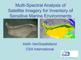
  • 1. Multi-Spectral Analysis of Satellite Imagery for Inventory of Sensitive Marine Environments Keith VanGraafeiland CSA International
  • 2. Overview • Remote sensing using satellite imagery is a cost means for mapping a large area in a short amount of time. • Clear water applications ~30m deep • Different methods: – Supervised classification • Uses field survey data (various types) – Unsupervised classification – Resolution and accuracy is directly correlated to the resolution of the original source imagery.
  • 3.
  • 4.
  • 5. Satellite Information • Different satellites offer multiple options when ordering/tasking satellites to acquire imagery. • Resolution of common commercial satellites range from 30 m (LANDSAT) to 60 cm (QuickBird). • Different bands provided in satellite imagery offer multiple techniques associated with identifying certain habitats. • Normalized Difference Vegetation Index (NDVI) can be applied to delineate mangroves from surrounding vegetation. NDVI is a simple formula using two satellite channels. If one band is in the visible region (VIS) and one is in the near infrared (NIR), then the NDVI is (NIR - VIS)/(NIR +VIS). This method is successful for identifying the spectral signature of mangroves in imagery where four bands were available.
  • 6. Supervised Classification • Independent in situ datasets. – Satellite data – Field Survey data • High accuracy GPS unit • Video • Depth transducer • Towed sensor platform (“towfish”) • Spectral Radiometers – Correct atmospheric conditions for the time period that the satellite was collecting imagery. • Corrections for water column. • Spectral signatures need to be collected for values you would like to map.
  • 7. Supervised Classification If not able to be in the field at the time of imagery acquisition then you can still ground truth the data. Disadvantages of this include: No atmospheric correction (upwelling, reflectance) relative to the Areas where there are environmental changes that occur over time, such as seasonal or yearly trends will
  • 8. Unsupervised Classification • Satellite imagery • Classification is done based upon computer clustering of spectral signature values. • The user is responsible for distinguishing what habitat is associated with each cluster. • Use existing datasets (charts, bathymetry, etc.) to aid in image interpretation when ground truth data is limited.
  • 9. Tidal sea-grass overlaid on original imagery.
  • 10. Sand/land classification overlaid on original imagery.
  • 11.
  • 12. Applications • Fiber Optic Cable Landings • Pipeline Landings • Seismic Cable Impacts • Habitat Sensitivity Mapping
  • 13. Hard Bottom Mapping – Indian River County, FL – Used to monitor dredge impacts.