This document summarizes research on using signals from high definition television (HDTV) towers for spacecraft navigation. Key points:
1) HDTV signals have a well-defined structure that allows extraction of navigation data like pseudorange and range rate.
2) Correlating received signals to known patterns in the signal's frame synchronization segments provides measurements for determining signal timing and Doppler shift.
3) Initial results show HDTV signals can support navigation for spacecraft as far away as the Moon, at very low cost compared to existing deep space navigation networks.
4) Future work involves further characterizing measurement accuracy and leveraging signals from HDTV networks worldwide for global navigation coverage.
The effects of using variable lengths for degraded signal acquisition in GPS ...
Pasadena Poster Fa15
1. Introduction
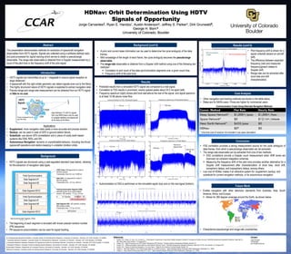
HDNav: Orbit Determination Using HDTV
Signals of Opportunity
Jorge Cervantes║, Ryan E. Handzo*, Austin Anderson‡, Jeffrey S. Parker†, Dirk Grunwald¶,
George H. Born§
University of Colorado, Boulder
Cost Analysis
Background (cont’d)
References:
1. Handzo, R.E., Parker, J.S., Born, G.H., & Gold, K.L., “Using Signals of Opportunity in Deep Space Satellite Navigation: Breadth of Coverage and Solution Accuracy,” AAS/AIAA Astrodynamics Specialist Conference, Paper AAS 13-
830, Hilton Head, South Carolina, 11-15 August 2013.
2. Handzo, R.E., “Signal Processing of an HDTV Signal Following the ATSC Standard.” Colorado Center for Astrodynamics Research, Boulder, CO.
3. Handzo, R.E., “Obtaining Navigation Observables from High Definition Television Towers.” AAS/AIAA Astrodynamics Specialist Conference, Paper AAS 15-776, Vail, Colorado, 10-13 August 2015
4. Handzo, R.E., “Signals of Opportunity Navigation in Cis-Lunar Space,” Thesis for the University of Colorado Boulder, Boulder, CO.
5. Vrotsos, P., “Near Earth Network FY 2011 Reimbursable Rates for non-NASA Customers,” Space Operations Mission Directorate, NASA Headquarters, Washington D.C., 20546.
6. Vrotsos, P., “Space Network Reimbursable Rates for FY 2015,” Space Operations Mission Directorate, NASA Headquarters, Washington D.C., 20546.
Future Work
Background
Abstract
Results
Comm. Method Flat Rate Hourly Rate
Deep Space Network5 $1,000+/pass $1,000+/hour
Space Network6 $0 $12.14+/minute
Near Earth Network4 $435/pass $0
HDNav $0* $0
• Other navigation and tracking methods are shown in the table below.
• Rates are for NASA users. Prices are higher for commercial users.
Communication Costs Using Alternate Navigation Methods
* One-time cost of receiver not included in per-pass calculation
Conclusion
• HDTV signals are structured using a well-regulated standard (see below), allowing
for the extraction of navigation data types.
• The beginning of each segment is encoded with known pseudo-random number
(PN) sequence.
• PN sequence autocorrelation can be used for signal tracking.
Field Synchronization
Segment #2Data Segment #1
Data Segment #2
Data Segment #312
Field Synchronization
Segment #1Data Segment #1
Data Segment #2
Data Segment #312
Data Synchronization Segment (DSS):
-1, 1, 1, -1
Field Synchronization Segment (FSS):
Identified quickly via an autocorrelation
function. 832 symbols. 77.3 μs, 23.2 km
ATSC Frame: 626 segments for a total of
520,832 symbols.
Transmission time: 24.2 ms, 14,508 km
4 511 Symbols 63 63 63 128
FSS 2 is inverted from FSS 1
Data Segment (DS): 832 symbols, including
828 symbols of data.
Transmission time: 77.3 μs, 23.2 km
4 828 Symbols
Data Field: 313 segments for a total of
260,416 symbols.
Transmission time: 12.2 ms, 7254 km
This presentation demonstrates methods for extraction of spacecraft navigation
observables from HDTV signals. Signals are collected using a software-defined radio
and post-processed for signal tracking which serves to obtain a pseudorange
observable. The range-rate observable is obtained from a Doppler measurement by a
count of the pilot tone or the frequency shift of the pilot signal.
AUS
USA
EuropeJapan
High Definition TV (HDTV) signals
from over 8800 towers may be used
to navigate satellites and spacecraft
as far away as the Moon.
Towers broadcast from all
over the world.
HDTV
Signals
• Predicted results from a simulated HDTV signal are compared to a real signal.
• Correlation to FSS results in prominent, evenly spaced peaks about 24.2 ms apart (left).
• Frequency spectrum (right) shows pilot tone well-above the rest of the signal, and signal spectrum
is at least 10 dB above noise floor.
• Autocorrelation to DSS is performed on the simulated signal (top) and on the real signal (bottom).
Results (cont’d)
• A priori and current state information can be used to determine the cycle ambiguity of the data
frames.
• With knowledge of the length of each frame, the cycle ambiguity becomes the pseudorange
observable.
• The range-rate observable is obtained from a Doppler shift method using one of the following two
methods3:
Correlation to and count of the data synchronization segments over a given count time.
Frequency shift of the pilot tone.
• Pilot frequency shift is shown for a
signal collected aboard an aircraft
(left).
• The difference between expected
frequency (red) and measured
frequency(green) relates to
Doppler shift.
• Range-rate can be extracted after
clock bias and drift
characterization.
║ Undergraduate Research Assistant, Colorado Center for Astrodynamics Research, University of Colorado – Boulder, 431 UCB, Boulder, CO 80309
* Graduate Research Assistant, Colorado Center for Astrodynamics Research, University of Colorado – Boulder, 431 UCB, Boulder, CO 80309
‡ Graduate Research Assistant, Research & Engineering Center for Unmanned Vehicles, University of Colorado – Boulder, 431 UCB, Boulder, CO 80309
† Assistant Professor, Colorado Center for Astrodynamics Research, University of Colorado – Boulder, 431 UCB, Boulder, CO 80309
¶ Associate Professor, Department of Computer Science, University of Colorado – Boulder, 431 UCB, Boulder, CO 80309
§Director Emeritus, Colorado Center for Astrodynamics Research, University of Colorado – Boulder, 431 UCB, Boulder, CO 80309
• FSS correlation provides a strong measurement source for the cycle ambiguity of
data frames, from which a pseudorange observable can be extracted.
• The range-rate observable can be extracted from one of two methods:
DSS correlations provide a Doppler count measurement when SNR levels are
improved via coherent integration schemes.
Measuring the frequency shift of the pilot tone provides another alternative for a
Doppler shift measurement after characterization of clock bias, clock drift,
ionospheric delays, and tropospheric delays, among others.
• Low cost of HDNav makes it an attractive system for: supplement, backup, and
substitute for current navigation methods, or for autonomous navigation.
Pilot tone predicted location
Pilot tone measured
location
• Enable navigation with other television standards from Australia, Asia, South
America, Africa, and Europe
Allows for 360 degree coverage around the Earth, as shown below
• Characterize pseudorange and range-rate uncertainties
• HDTV signals are transmitted at up to 1 megawatt to ensure signal reception at
large distances1.
• A spacecraft with the right orbital geometry can detect signals even out to the Moon.
• The highly structured nature of HDTV signals is exploited to extract navigation data.
• Pseudo-range and range-rate measurement can be obtained from an HDTV signal
at little to no cost.
Applications
• Supplement: more navigation data yields a more accurate and precise solution.
• Backup: can be used in case of GPS or ground-station failure.
• Substitute: use above GPS constellation and in place of costly earth based
systems like DSN, NEN, and SN.
• Autonomous Navigation: dynamic or unpredictable behavior, including low-thrust
spacecraft operations and station-keeping in unstable Libration orbits.
Pilot tone
Pilot tone
Pilot tone of
adjacent band
Adjacent band
24.2 ms
~24.2 ms
Contact:
Jorge Cervantes
720-299-3854
joce7341@Colorado.edu