Professional Surveying of Memphis Cypress Creek Drainage Basin
•
0 gefällt mir•55 views

Arc Surveying & Mapping, Inc.
Empfohlen

Empfohlen
Weitere ähnliche Inhalte
Was ist angesagt?
Was ist angesagt? (20)
Andere mochten auch
Andere mochten auch (14)
Ähnlich wie Professional Surveying of Memphis Cypress Creek Drainage Basin
Ähnlich wie Professional Surveying of Memphis Cypress Creek Drainage Basin (20)
Mehr von Arc Surveying & Mapping, Inc.
Mehr von Arc Surveying & Mapping, Inc. (6)
Kürzlich hochgeladen
Kürzlich hochgeladen (20)
Professional Surveying of Memphis Cypress Creek Drainage Basin
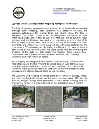
- 1. ARC SURVEYING & MAPPING, INC. PROFESSIONAL SURVEYING SOLUTIONS SINCE 1986 www.arcsurveyors.com 5567 Commander Dr., Ste 101 5202 San Juan Ave 4160 Minton Road Arlington, TN 38002 Jacksonville, FL 32210 Melbourne, FL 32904 (901) 867-5333 (904) 384-8377 (321) 728-8688 Cypress Creek Drainage Basin Mapping Memphis, Tennessee The City of Memphis contracted several teams of professionals to complete drainage basin mapping, data collection, GIS database creation, and hydraulic calculations for several large sub basins within the City of Memphis. The project consisted of the topographic survey of all open channels, ditches, and canals at 500 foot intervals, bridge surveys, cross sections, and the location, size, and invert elevations of every pipe of 24 inch or larger in each basin. In addition, a catalog of drainage structures, manholes, and inlets were to be surveyed and attributes assigned for the creation of a GIS database. Arc Surveying and Mapping, Inc. was an integral part of one of the selected teams. We were tasked with the surveying and prepping of the data for GIS input. The Cypress Basin (shown here) consisted of over 4,500 Acres and contained well over 2000 drainage structures and over 4 miles of canals. Arc Surveying and Mapping had to create traverses using Trimble Robotic Total stations and Trimble RTK GPS to collect data on over 2000 drainage structures such as curb inlets, surface drains, manholes, and culverts. All structures were located horizontally, vertically, and invert elevations were surveyed using standard topographic survey methods. Arc Surveying and Mapping traversed along over 4 miles of ditches, canals, and concrete lined ditches performing cross sections every 500 feet. In addition, bridge surveys were performed at each street crossing and box bridges. Arc had several crews working on this project for over 4 months collecting data.