1. Forest Canopy Coverage Adjacent to Forest Roads
and its Effect on Invasive Plant Species
Beth Lewis and Sherry Wood
Department of Biology, Gonzaga University, Spokane, Washington
1.5 kb
1 kb
Introduc)on
Methods
Results
Conclusions
and
Future
Work
State
and
Federal
Agencies
manage
forest
roads
in
order
to
provide
access
for
forest
use
to
the
public.
Employees
monitor
the
spread
of
invasive
weed
species
that
overrun
roadsides
and
outcompete
nave
plant
species.
Invasive
weed
species
are
alien
species
whose
introducon
does
or
is
likely
to
cause
environmental
harm.
The
Idaho
Panhandle
Naonal
Forest
(IPNF)
contains
2.5
million
acres
and
has
over
11,000
miles
of
roads.
The
Coeur
d’Alene
River
District
in
northern
Idaho
spends
$25.50
per
acre
of
road
spraying
roadsides
with
herbicides
to
inhibit
invasive
plant
species.
If
the
Forest
Service
were
to
spray
every
road
throughout
the
IPNF,
they
would
be
spending
over
1.5
million
dollars
a
year
on
herbicide
treatment.
Managing
invasive
weed
species
is
incredibly
important
due
to
the
detrimental
effects
on
the
environment
and
the
toxicity
the
plants
have
on
nave
animals.
(DiTomaso,
2000)
Connuing
to
spray
the
roadsides
with
herbicides
influences
not
only
the
invasive
weeds,
but
also
may
damage
nave
species.
(Rinella
et
al.
2009)
An
alternave
way
of
reducing
the
abundance
of
invasive
weed
species
was
studied
by
a
team
of
research
students
who
collected
data
on
forest
canopy
coverage
and
invasive
weed
species
presence.
Canopy
coverage
is
the
percentage
of
the
forest
floor
covered
by
the
vercal
projecon
of
the
tree
crowns.
If
canopy
coverage
has
a
negave
impact
on
invasive
weed
species,
keeping
roads
narrower
would
minimize
the
herbicides
needed
to
manage
invasive
species.
As
forest
canopy
coverage
increases
the
presence
of
invasive
weed
species
will
decrease.
Roads
in
the
IPNF
in
the
Coeur
d’Alene
River
watershed
were
selected
and
each
assigned
around
fiVy
random
points
distributed
within
7
meters
on
either
side
of
the
roads
centerline.
610
plots
were
recorded.
The
roads
were
all
heterogeneous
in
nature
and
differed
in
roadside
canopy
coverage,
elevaon,
treatment
and
fire
history.
Each
point
was
found
using
GPS
coordinates.
A
one-‐meter
by
one-‐meter
plot
was
laid
down
at
the
coordinate
site
and
every
plant
species
within
the
plot
was
recorded
and
the
percent
coverage
was
esmated
using
Daubenmire
Cover
Classes.
A
spherical
densiometer
was
used
to
record
the
canopy
coverage
of
the
tree
crowns
directly
overhead
the
plots.
JMP
12.0
was
used
to
examine
the
relaonship
between
forest
canopy
coverage
and
the
percent
cover
of
invasive
weed
species
adjacent
to
the
forest
roads.
Forest
canopy
coverage
percentage
was
compared
to
each
of
the
different
invasive
weed
species.
Only
two
of
the
seven
plants
we
studied
showed
a
significant
relaonship
between
canopy
coverage
and
invasive
weed
species
percentage.
Figures
1
and
2
had
a
negave
sloping
trend
showing
as
the
percent
canopy
coverage
increases
the
invasive
weed
species
presence
decreases.
Figure
1
shows
canopy
coverage
compared
to
St.
Johns
Wort
with
a
p-‐value
less
than
0.001
indicang
a
high
significance.
Figure
2
shows
canopy
coverage
compared
to
oxeye
daisy
with
a
p-‐value
of
0.0166
also
indicang
significance.
The
other
five
weed
species,
Spo^ed
Knapweed,
Meadow
Hawkweed
showed
no
correlaon
between
canopy
coverage
and
invasive
weed
species.
When
we
looked
at
the
sum
of
all
seven
invasive
weed
species
compared
to
the
percent
canopy
coverage
per
plot,
we
see
there
is
a
significant
difference
between
plots
with
high
canopy
coverage
and
low
canopy
coverage.
Figure
3
shows
plots
with
a
high
percentage
canopy
coverage
generally
had
a
lower
amount
of
invasive
weed
species
present
in
the
plot.
The
p-‐value
is
less
than
0.001
indicang
a
high
significant
difference.
Although
the
majority
of
the
invasive
weeds
were
not
significantly
affected
by
canopy
coverage,
the
high
significance
of
St.
Johns
Word
and
Oxeye
Daisy
overpowered
the
non-‐significant
comparisons.
Invasive
weed
species
move
into
forests
through
moving
along
road
corridors.
(Pauchard,
2004)
If
road
corridors
were
kept
narrower
with
higher
canopy
coverage
along
them,
we
could
expect
fewer
invasive
weed
species
would
grow
along
the
roadsides.
Herbicides
can
connually
be
used
as
a
method
to
treat
invasive
weed
species
however,
studies
show
that
they
can
become
resistant
to
herbicide
treatment
in
20
generaons.
(Prens,
2008)
By
keeping
the
roads
shaded,
there
is
a
higher
chance
that
herbicides
will
not
be
essenal
in
management
of
invasive
weed
species
allowing
the
Forest
Service
to
use
the
money
to
benefit
other
aspects
of
the
forest.
Sources
of
Error:
Error
could
come
from
a
few
different
factors.
When
recording
the
percent
canopy
coverage
with
the
spherical
densiometer,
if
the
same
person
did
not
take
the
measurement
each
me,
there
could
be
a
difference
in
their
technique,
increasing
a
chance
of
error.
Another
error
factor
could
come
from
different
people
assigning
cover
classes
to
the
different
weeds
in
each
plot.
These
could
have
affected
the
overall
results,
causing
a
gain
or
loss
in
significance
between
canopy
coverage
and
invasive
weed
species.
Future
Work:
Connuing
this
project
would
provide
vital
informaon
for
the
Forest
Service
so
they
can
connue
to
manage
the
roads
in
the
most
efficient
way
possible.
By
taking
into
account
elevaon
and
herbicide
treatments
a
more
comprehensive
conclusion
on
canopy
coverage
effect
could
be
made.
References
and
Acknowledgements
Thank
you
to
Sherry
Wood
for
aiding
in
project
development
and
supervision.
Forest
Service
employee
Gilbert
Moreno
aided
in
idenficaon
of
endless
plants.
This
research
was
supported
in
part
by
a
grant
to
Gonzaga
University
from
the
Howard
Hughes
Medical
Instute
through
the
Undergraduate
Science
Educaon
Program.
DiTomaso,
J
(2000,)
Invasive
weeds
in
rangelands:
Species,
impacts,
and
management.
Weed
Science:
March
2000,
Vol.
48,
No.
2,
pp.
255-‐265.
Pauchard,
A.
and
Alaback,
P.
B.
(2004),
Influence
of
Elevaon,
Land
Use,
and
Landscape
Context
on
Pa^erns
of
Alien
Plant
Invasions
along
Roadsides
in
Protected
Areas
of
South-‐Central
Chile.
Conservaon
Biology,
18:
238–248.
Prens,
P.,
Wilson,
R.
et
al.
(2008)
Adapve
evoluon
in
invasive
species,
Trends
in
Plant
Science,
Volume
13,
Issue
6,
Pages
288-‐294,
ISSN
1360-‐1385
Rinella,
M.
J.,
Maxwell,
B.
D.,
Fay,
P.
K.,
Weaver,
T.
and
Sheley,
R.
L.
(2009),
Control
effort
exacerbates
invasive-‐species
problem.
Ecological
Applicaons,
19:
155–162.
doi:10.1890/07-‐1482.1
Figure
2:
Bivariate
Fit
of
Oxeye
Daisy
by
Percent
Canopy
Coverage
The
comparison
of
the
percent
forest
canopy
coverage
in
a
plot
versus
the
percent
coverage
of
Oxeye
Daisy.
The
p-‐value
is
0.0166
indicang
a
significant
negave
relaonship
between
canopy
coverage
and
percent
coverage
of
Oxeye
Daisy.
Figure
3:
Bivariate
Fit
of
Sum
of
Weed
Coverage
by
Percent
Canopy
Coverage
The
comparison
of
percent
forest
canopy
coverage
in
a
plot
versus
the
total
sum
of
invasive
weed
coverage
percentages
per
plot.
The
p-‐value
is
less
than
0.001
indicang
a
significant
negave
relaonship
between
canopy
coverage
and
the
total
invasive
weed
species
coverage.
Figure
1:
Bivariate
Fit
of
St.
Johns
Wort
by
Percent
Canopy
Coverage
The
comparison
of
the
percent
forest
canopy
coverage
in
a
plot
versus
the
percent
coverage
of
St.
John’s
Wort.
The
p-‐value
is
less
than
0.001
indicang
a
significant
negave
relaonship
between
canopy
coverage
and
percent
coverage
of
St.
John’s
Wort.
Figure
4:
Bivariate
Fit
of
SpoNed
Knapweed
by
Percent
Canopy
Coverage
The
comparison
of
percent
forest
canopy
coverage
in
a
plot
versus
the
percent
coverage
of
Spo^ed
Knapweed.
Although
there
is
a
negave
linear
fit
line,
the
p-‐value
is
0.5535
indicang
there
is
not
a
significant
negave
relaonship
between
canopy
coverage
and
percent
coverage
of
Spo^ed
Knapweed.
Figure
5:
Roadside
Covered
by
Invasive
Weed
Species
A
roadside
covered
by
invasive
weeds
with
li^le
canopy
coverage.
St.
John’s
Wort
is
the
most
prevalent
weed.
Photo
was
taken
standing
in
the
middle
of
the
road.
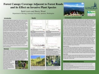
Figure
6:
Roadside
with
High
Canopy
Coverage
A
roadside
with
high
forest
canopy
coverage
and
li^le
invasive
weed
species
presence.
Photo
was
taken
standing
in
the
middle
of
the
road.