Wall Street Network case study
•
1 gefällt mir•259 views

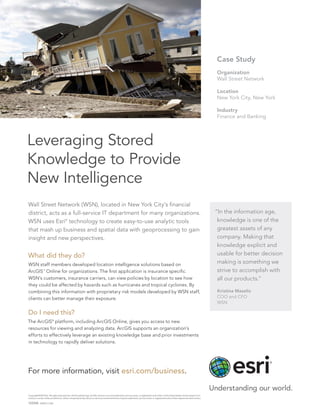
Wall Street Network used ArcGIS Online to leverage stored knowledge to provide new intelligence.
Empfohlen

Empfohlen
Weitere ähnliche Inhalte
Was ist angesagt?
Was ist angesagt? (20)
Andere mochten auch
Ähnlich wie Wall Street Network case study
Ähnlich wie Wall Street Network case study (20)
Mehr von Esri
Mehr von Esri (20)
Kürzlich hochgeladen
Kürzlich hochgeladen (20)
Wall Street Network case study
- 1. Wall Street Network (WSN), located in New York City’s financial district, acts as a full-service IT department for many organizations. WSN uses Esri® technology to create easy-to-use analytic tools that mash up business and spatial data with geoprocessing to gain insight and new perspectives. What did they do? WSN staff members developed location intelligence solutions based on ArcGIS SM Online for organizations. The first application is insurance specific. WSN’s customers, insurance carriers, can view policies by location to see how they could be affected by hazards such as hurricanes and tropical cyclones. By combining this information with proprietary risk models developed by WSN staff, clients can better manage their exposure. Do I need this? The ArcGIS® platform, including ArcGIS Online, gives you access to new resources for viewing and analyzing data. ArcGIS supports an organization’s efforts to effectively leverage an existing knowledge base and prior investments in technology to rapidly deliver solutions. “In the information age, knowledge is one of the greatest assets of any company. Making that knowledge explicit and usable for better decision making is something we strive to accomplish with all our products.” Kristina Mazelis COO and CFO WSN Leveraging Stored Knowledge to Provide New Intelligence Case Study Organization Wall Street Network Location New York City, New York Industry Finance and Banking For more information, visit esri.com/business. Copyright © 2013 Esri. All rights reserved. Esri, the Esri globe logo, ArcGIS, and esri.com are trademarks, service marks, or registered marks of Esri in the United States, the European Com- munity, or certain other jurisdictions. Other companies and products or services mentioned herein may be trademarks, service marks, or registered marks of their respective mark owners. 133344 ESRI2C1/13dh