10. Preperation of the Flood Risk Management Plans - Mark Adamson
•
0 gefällt mir•1,148 views

This presentation was given at the Catchment Management Network meeting on February 24th 2017. The Catchment Management Network consists of the EPA, all of Ireland's Local Authorities, and other public bodies involved in looking after Ireland's catchments, sub-catchments and water bodies. For more information about this work see www.catchments.ie

Empfohlen
Empfohlen
Weitere ähnliche Inhalte
Was ist angesagt?
Was ist angesagt? (20)
Andere mochten auch
Andere mochten auch (9)
Ähnlich wie 10. Preperation of the Flood Risk Management Plans - Mark Adamson
Ähnlich wie 10. Preperation of the Flood Risk Management Plans - Mark Adamson (20)
Mehr von Environmental Protection Agency, Ireland
Mehr von Environmental Protection Agency, Ireland (20)
Kürzlich hochgeladen
Kürzlich hochgeladen (20)
10. Preperation of the Flood Risk Management Plans - Mark Adamson
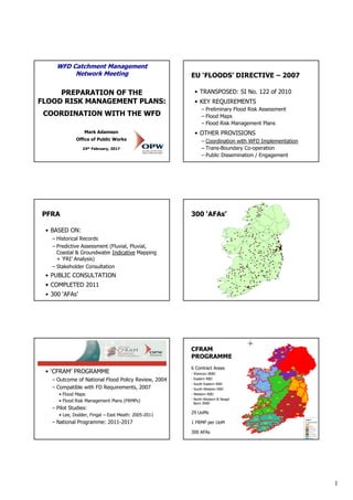
- 1. 1 WFD Catchment Management Network Meeting PREPARATION OF THE FLOOD RISK MANAGEMENT PLANS: COORDINATION WITH THE WFD Mark Adamson Office of Public Works 24th February, 2017 EU ‘FLOODS’ DIRECTIVE – 2007 • TRANSPOSED: SI No. 122 of 2010 • KEY REQUIREMENTS – Preliminary Flood Risk Assessment – Flood Maps – Flood Risk Management Plans • OTHER PROVISIONS – Coordination with WFD Implementation – Trans-Boundary Co-operation – Public Dissemination / Engagement PFRA • BASED ON: – Historical Records – Predictive Assessment (Fluvial, Pluvial, Coastal & Groundwater Indicative Mapping + ‘FRI’ Analysis) – Stakeholder Consultation • PUBLIC CONSULTATION • COMPLETED 2011 • 300 ‘AFAs’ 300 ‘AFAs’ ‘CFRAM’ STUDIES • ‘CFRAM’ PROGRAMME – Outcome of National Flood Policy Review, 2004 – Compatible with FD Requirements, 2007 • Flood Maps • Flood Risk Management Plans (FRMPs) – Pilot Studies: • Lee, Dodder, Fingal – East Meath: 2005-2011 – National Programme: 2011-2017 CFRAM PROGRAMME 6 Contract Areas - Shannon IRBD - Eastern RBD - South-Eastern RBD - South-Western RBD - Western RBD - North-Western & Neagh Bann IRBD 29 UoMs 1 FRMP per UoM 300 AFAs
- 2. 2 • MANAGEMENT STRUCTURES – National • National Steering Group • National Stakeholder Group • National Technical Coordination Group – RBD-Level • Steering Group • Progress Group • Stakeholder Group • MANAGEMENT STRUCTURES – Coordination with WFD • Cross-Representation: – WFD: OPW Representation on WPAC, National Implementation Group, Working Groups, Catchment Management Network – FD: WFD Representation on National and RBD Steering / Progress Groups • Tri-/Bi-Lateral Meetings (DCHPLG/EPA/OPW) • National / RBD Stakeholder Group • Information Exchange • Coordination on Measures • SCOPE OF WORK – Survey • 10,000km2 LiDAR-based DTM • Appx. 6,500km Channel (topo) Survey – Data Collection – Hydrology – Hydraulics / Flood Mapping ‘CFRAM’ STUDIES • FLOOD MAPS: – Current Scenario Mapping • Extent, Depth, Velocity, ‘Risk-to-Life’, Flood Zone – Up to 8 Probabilities • 7 Risk Maps
- 3. 3 ‘CFRAM’ STUDIES • FLOOD MAPS: – Current Scenario Mapping • Extent, Depth, Velocity, ‘Risk-to-Life’, Flood Zone – Up to 8 Probabilities • 7 Risk Maps – Future Scenario Mapping • 2 Representative Climate Futures – Public Consultation • Appx. 200 ‘PCDs’ (Community-Level Consultation) • Formal ‘SI’ Consultation (2015) FLOOD MAPS - 300 Communities, Incl 90 Coastal Communities, Incl Appx. 4,000 kms Detailed Flood Mapping - Appx. 2,500 kms Other Mapped River - Inform Sustainable Planning, Emergency Response Planning & Resilience • FRMPs – Appraisal of Flood Risk Management Options • Cost-Benefit Assessment (CBA) • Multi-Criteria Analysis (MCA) – Assessment of Benefits and Impacts of Potential Measures across Range of Sectors / Objectives, Incl. Social, Economic and Environmental – Objectives subject to Public Consultation – Weightings based on Structured Public Consultation – MCA Informs Identification of Preferred Measures in Terms of Overall Benefits and Impacts on Balance across the Wide Range of Objectives
- 4. 4 • FRMPs – MCA Objective 3.a: • “Support the objectives of the WFD – Provide no impediment to the achievement of water body objectives and, if possible, contribute to the achievement of water body objectives.” – Assessment of Potential Benefits / Impacts re. WFD Objectives • At CFRAM-Level of Assessment – Inform Art. 4(7) Assessment at Next Stage of Progression for Measures • FRMPs – Appraisal of Flood Risk Management Options • Cost-Benefit Assessment (CBA) • Multi-Criteria Analysis (MCA) – SEA – Appropriate (Habitats) Assessment – Public Consultation: • Formal SI Consultation (Web / LA Offices) • Appx. 250 PCDs (Options & Draft FRMPs) • FRMPs – Status: • FRMP (when approved) is NOT Consent for Construction of Physical Measures • Measures are NOT Final and Definitive – Next Step for Physical Measures: • Project-Level Assessment and Development for Planning / Exhibition • Involve EIA, AA (Screening), Incl. Consideration of Alternatives • Scope to Assess at Project-Level and Incorporate WFD-FD ‘Win-Win’ Measures / NWRM • FRMPs – Next Steps: – Review of Submissions on Draft FRMPs: • Ongoing – Prioritisation of Measures – Final FRMPs to Minister/PER for Approval • Approve, Make Amendments, Reject – Councils May Adopt Final FRMPs WFD Catchment Management Network Meeting PREPARATION OF THE FLOOD RISK MANAGEMENT PLANS: COORDINATION WITH THE WFD Mark Adamson Office of Public Works 24th February, 2017