CLEARINGHOUSE FOR GEO-SPATIAL DATA FOR AN EMERGENCY PERSPECTIVE

During emergencies, spatial data plays an important role in analyzing situations and informing decisions. However, accessing and managing this geospatial data across different agencies can be challenging. To address this, many countries have established national spatial data clearinghouses that serve as online portals allowing emergency forces to access and share static and dynamic geospatial data in a single place. However, issues remain such as a lack of standardization and interoperability between specialized systems, insufficient funding, and challenges managing field data. The paper proposes developing an effective clearinghouse for Nepal that can help coordinate emergency response by facilitating access to up-to-date geospatial data and information.

Empfohlen
Empfohlen
Weitere ähnliche Inhalte
Was ist angesagt?
Was ist angesagt? (20)
Ähnlich wie CLEARINGHOUSE FOR GEO-SPATIAL DATA FOR AN EMERGENCY PERSPECTIVE
Ähnlich wie CLEARINGHOUSE FOR GEO-SPATIAL DATA FOR AN EMERGENCY PERSPECTIVE (20)
Kürzlich hochgeladen
Kürzlich hochgeladen (20)
CLEARINGHOUSE FOR GEO-SPATIAL DATA FOR AN EMERGENCY PERSPECTIVE
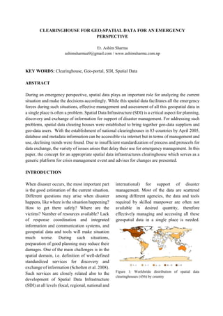
- 1. CLEARINGHOUSE FOR GEO-SPATIAL DATA FOR AN EMERGENCY PERSPECTIVE Er. Ashim Sharma ashimsharmaa9@gmail.com / www.ashimsharma.com.np KEY WORDS: Clearinghouse, Geo-portal, SDI, Spatial Data ABSTRACT During an emergency perspective, spatial data plays an important role for analyzing the current situation and make the decisions accordingly. While this spatial data facilitates all the emergency forces during such situations, effective management and assessment of all this geospatial data in a single place is often a problem. Spatial Data Infrastructure (SDI) is a critical aspect for planning, discovery and exchange of information for support of disaster management. For addressing such problems, spatial data clearing houses were established to bring together geo-data suppliers and geo-data users. With the establishment of national clearinghouses in 83 countries by April 2005, database and metadata information can be accessible via internet but in terms of management and use, declining trends were found. Due to insufficient standardization of process and protocols for data exchange, the variety of issues arises that delay their use for emergency management. In this paper, the concept for an appropriate spatial data infrastructures clearinghouse which serves as a generic platform for crisis management event and advises for changes are presented. INTRODUCTION When disaster occurs, the most important part is the good estimation of the current situation. Different questions may arise when disaster happens, like where is the situation happening? How to get there safely? Where are the victims? Number of resources available? Lack of response coordination and integrated information and communication systems, and geospatial data and tools will make situation much worse. During such situations, preparation of good planning may reduce their damages. One of the main challenges is in the spatial domain, i.e. definition of well-defined standardized services for discovery and exchange of information (Scholten et al. 2008). Such services are closely related also to the development of Spatial Data Infrastructure (SDI) at all levels (local, regional, national and international) for support of disaster management. Most of the data are scattered among different agencies, the data and tools required by skilled manpower are often not available in desired quantity, therefore effectively managing and accessing all these geospatial data in a single place is needed. Figure 1: Worldwide distribution of spatial data clearinghouses (456) by country
- 2. Addressing all these issues and problems, a mechanism is developed for the exchange and sharing of static and dynamic geo-spatial data between the emergency forces, “clearing house”; a web-portal serving as the gate-way to geospatial data and information. Recent research has shown that by April 2005, 83 countries have established SDI internet-based clearinghouses to bring together geo-data suppliers and geo-data users, whilst 25 countries have started projects to build clearinghouses (Lemmens 2006). With the clearinghouses available, database and metadata information can be accessible via the internet. A spatial data clearinghouse can be defined as an electronic facility for searching, viewing, transferring, ordering, advertising and/or disseminating spatial data from numerous sources via the Internet. Such a facility usually consists of a number of servers, which contain information (metadata) about available digital data (Crompvoets 2006). It gives uniform, distributed search to all domestic metadata collections through a single user interface to find data and maps. Figure 2: Schematic structure of clearinghouses Clearinghouses provides a framework for collecting, analyzing and using complex spatial data to help countries dealing with national and global challenges. It includes different applications like flood management, landslide monitoring etc. from where we can remotely assess damage and potential dangers without physically entering dangerous and inaccessible areas. This helps experts to make important decisions for further actions. Development of effective clearinghouses help to explore, structure and solve complex spatial problems such as the evacuation process in disaster response. Disaster response support can be enhanced to provide dynamism and flexibility with the integration of simulation models with GIS for which can be accessed through geoportals. Figure 3: An overview of context-aware SDI for disaster management CLEARINGHOUSE IN NEPAL FOR EMERGENCY PERSPECTIVE In Nepal, National Spatial Data Infrastructure (NSDI) is the common portal to view and use geospatial data in effective and efficient way and link with other attribute database. Government of Nepal has initiated the National Geographical Information Infrastructure Programme (NGIIP) for building national spatial data infrastructure since 2002. Nepal Geospatial Portal is being developed with the technical support of ICIMOD. From Nepal Geospatial Portal, users (spatial data producers) can upload the geospatial data produced by them and administrator (NGIIP) will check the quality (BC 2015). Nepal’s national action plan on disaster management consists of four main plans on: disaster preparedness, disaster response, disaster reconstruction and rehabilitation action, and disaster mitigation. (Ministry of Home Affairs
- 3. 1996). During the 2015 earthquake in Nepal which affected 31 districts, pre and post disaster satellite images, maps and data were provided free to support Rescue and Recovery activities by many organizations. Survey Department also provided vector topographic data of the earthquake-affected districts. Many national and international organizations involved to prepare maps and information and disseminated information online. A preliminary study of displacement due to earthquake was also carried out by Survey Department, after the earthquake with the observation of 5 higher order control points around Kathmandu Valley (BC 2015). For reconstruction and resettlements, the role of integrated and updated statistical and geospatial information played its part. Figure 4: NSDI Clearinghouse provided by Survey Department (http://nationalgeoportal.gov.np/) In July 2, 2008 workshop was conducted on Spatial Data Infrastructure and Disaster management where initiatives for facilitating the development of suitable infrastructures of geographic information and establishment of disaster management support system at appropriate level in the country was discussed. The conclusion was drawn to constitute a high level geographic information committee to enhance inter-agency cooperation and to manage all sectors involved in collection and handling of spatial data and information. Also all government agencies should take necessary initiatives to establish a GIS unit and to facilitate easy sharing of data among eachother for informed decision making and coordinated development of NGII. RESULTS Most of the countries have already established an effective SDI internet-based clearinghouses regarding emergency management framework, however, there are numerous underlying obstacles that complicate an adequate crisis response. • Lack of good communication between sectors in emergency response due to operability of these sectors with particular systems, which makes it difficult to exchange the information between all sectors. • A variety of narrow specialized systems for only emergency situations. • Lack of appropriate platform (user- friendly interfaces) for data exchange. • Insufficient standardization of processes and protocols, especially for data exchange and proper funding. • Management of information from the field (reports, images, video, dynamic data, etc.) DISCUSSION SDI clearinghouses is considered as a critical aspect of decision-making in disaster management. Disasters occurs in every part of any country with little or no warning, so the best defense is to plan for an effective response. Although many of the geospatial data needed for emergency response generally have already been developed by communities for other purposes, there are a variety of issues, plans and policies that currently delay their use for emergency management. Therefore, steps must be taken to explicitly recognize and meet the geospatial needs of the emergency management field.
- 4. REFERENCES BC, K. R. 2015. “Spatial Data Infrastructure and Sustainable Development in the context of Nepal” The 20th UNRCC-AP and 4th UN- GGIM-AP. Jeju Island, Republic of Korea Crompvoets, Joep. 2006. National Spatial Data Clearinghouses: Worldwide Development and Impact. PROEFSCHRIFT. De Vries, Walter, Tandang Yuliadi Dwi Putra, and Trias Aditya. 2010. “Making Sense of Local Spatial Data Infrastructure in Volcanic Disaster Risk Management : A Case Study at Sleman Regency, Indonesia.” Pp. 219–34 in. Lemmens, Dr Mathias. 2006. “Spatial Data Clearinghouses.” Spatial Data Clearinghouses. https://www.gim- international.com/content/article/spatial-data- clearinghouses (February 5, 2019). Ministry of Home Affairs 1996. “Nepal: National Action Plan on Disaster Management in Nepal -Policy, Plans & Statements - Knowledge Base -PreventionWeb.Net.” Retrieved November 15, 2020 (https://www.preventionweb.net/english/profe ssional/policies/v.php?id=30532). Scholten, Henk, Steven Fruijter, Arta Dilo, and Erik van Borkulo. 2008. “Spatial Data Infrastructure for Emergency Response in Netherlands.” In Remote Sensing and GIS Technologies for Monitoring and Prediction of Disasters, eds. Shailesh Nayak and Sisi Zlatanova. Berlin, Heidelberg: Springer Berlin Heidelberg,179–97. http://link.springer.com/10.1007/978-3-540- 79259-8_11 (February 5, 2019).