#5
- 1. ATMOSPHERIC SCIENCE LETTERS
Atmos. Sci. Let. (2014)
Published online in Wiley Online Library
(wileyonlinelibrary.com) DOI: 10.1002/asl2.546
Commentary
World’s greatest rainfall intensities observed by satellites
Jose Agustin Breña-Naranjo,1
* Adrian Pedrozo-Acuña1
and Miguel A. Rico-Ramirez2
1Institute of Engineering, UNAM, Mexico
2Department of Civil Engineering, University of Bristol, UK
*Correspondence to:
J. A. Breña-Naranjo, Institute of
Engineering, Ciudad Universitaria,
Mexico D.F. 04510, Mexico.
E-mail: jbrenan@ii.unam.mx
Received: 28 May 2014
Revised: 30 July 2014
Accepted: 28 October 2014
Abstract
This commentary emphasizes the role of remote sensing tools for detecting extreme values
in precipitation. Here, we provide a synthesis of recent data from the Tropical Rainfall
Measurement Mission satellite to detect the rainfall maxima depth versus duration across the
terrestrial surface since 1998. Observations with rain gauges and satellite merged products
suggest similarities in the power scaling law between maximum rainfall depth and duration.
Satellites have shown the potential to identify regions of extreme precipitation and this is the
first study where intensity-duration curves from rainfall events measured by satellites are
compared with the same curves obtained with traditional rain gauges.
Keywords: rainfall; satellite; extremes
Previous compilations of the world’s greatest rainfall
depths for different durations are based on point mea-
surements sparsely located on the global terrestrial sur-
face with significant gaps in remote continental regions
and oceans. Such observations have suggested an intrin-
sic scaling relationship, also known as the Jennings law
(Jennings, 1950) that states that the maximum possible
rainfall (R) for a given cumulative duration (D) ranging
from hours to years is limited by local thermodynamics
and large-scale physical factors. As noted by Field and
Shutts (2009), several studies have suggested that the
distribution of rainfall responds to the local concentra-
tion of water and energy. Such phenomenon seems to
follow a fractal-type attenuation process as the spatial
scale decreases and, as shown by Zhang et al. (2013),
the Jennings law is not the exception.
This precipitation–duration relationship follows a
power law R ≈ aDb
where the precipitation intensity R
is in mm and the duration D in minutes. The b expo-
nent usually ranges between 0.4 for historical records
observed by single rain gauges and it gets close to 0.5
for a worldwide compilation of the maximum observed
rainfall over a given time scale (Zhang et al., 2013).
Recent studies have provided probabilistic (Galmarini
et al. 2004) and stochastic (Zhang et al., 2013) expla-
nations of such scaling law at the rain gauge point
scale. It is however unknown how that relationship
behaves for larger spatial scales in comparison to the
conventional ∼1 m2 footprint of a typical rain gauge.
Given the sparse geographical distribution of weather
radars over the world, rainfall estimates from satellite
observations offer the possibility of monitoring rain-
fall extremes over tropical and temperate regions across
the world and hence to explore the Jennings law at
a mesoscale. Also, for the first time, satellite-based
precipitation products allow to describe Jennings law
over oceanic regions. This work provides a compari-
son of Jennings law at the microscale (rain gauge) as
observed during the 20th century (WMO, 1994) and
at the mesoscale (0.25∘ × 0.25∘) derived from satellite
rainfall estimations.
The Tropical Rainfall Measuring Mission (TRMM)
(Simpson et al., 1996; Kummerow et al., 2000) is a
joint U.S.-Japan satellite mission aiming at monitor-
ing the temporal and spatial patterns of rainfall at the
quasi-global scale (60∘N to 60∘S), providing contin-
uous information about the duration and intensity of
rainfall events that are crucial for water resources man-
agement, ecosystem health and risk assessment, among
others. Using spaceborne sensors, the launch of TRMM
in 1998 has continuously provided maps of daily and
sub-daily rainfall over terrestrial and oceanic regions
(e.g. Behrangi et al., 2012). Rainfall estimates pro-
vided by TRMM’s precipitation radar and microwave
imager have performed relatively well when compared
to conventional rainfall measurement tools such as
rain gauges and weather radars (Adeyewa et al., 2003;
Nicholson et al., 2003; Islam et al., 2012). Whereas
TRMM products have provided consistent informa-
tion about the patterns and processes that character-
ize rainfall on a significant portion of the Earth’s sur-
face, its performance in continental regions with com-
plex terrain and in subtropical and high latitude oceans
have been constrained by significant bias and false
alarm ratios (Dinku et al., 2010; Behrangi et al., 2012).
However, it is worth to mention that the TRMM under-
estimation of maxima rain rates, when compared to rain
gauges, is in part due to the fact that rain gauges are
representative of point rainfall measurements whereas
satellite rainfall estimates represent a larger spatial
footprint.
© 2014 Royal Meteorological Society
- 2. A. Breña-Naranjo, A. Pedrozo-Acuña and M. A. Rico-Ramirez
In order to provide improved quasi-global datasets
of rainfall, calibrated and merged TRMM rainfall
data products such as the Tropical Multi-satellite
Precipitation Analysis (TMPA, Huffman et al., 2007)
have been widely tested for research and operational
purposes. The TMPA products can be used to detect
and understand the nature of rainfall extremes across
the world’s terrestrial surface. However, the TMPA
product used in this analysis (3B42 Version 7) is
composed by passive microwave radiometer data
from six different satellite missions such as the TRMM
Microwave Imager, the Advanced Microwave Scanning
Radiometer for Earth Observing Systems (AMSR-E)
and Advanced Microwave Sounding Unit (AMSU),
both from the AQUA satellite, the Special Sensor
Microwave Imager and its successor, the Special
Sensor Microwave Imager/Sounder (SSMIS), from
the Block 5D-2 and, F-16, F-17 and F-18 satellites,
respectively, the Microwave Humidity Sounder (MHS,
from the POES and MetOp group of satellites), and
the microwave-adjusted merged geo-infrared (IR, from
Geostationary Earth Orbital satellites). All microwave
data are then intercalibrated to TRMM Combined
Instrument (TCI) precipitation estimates at the monthly
resolution (TRMM product 3B31). Recent studies
have used the TMPA daily 3B42 product to estimate
the response of extreme rainfall in tropical regions
to its interannual variability (O’Gorman, 2012) and
also to compare the global frequency of heavy rainfall
rates estimated by a general circulation model to those
observed by satellites (Wilcox and Donner, 2007).
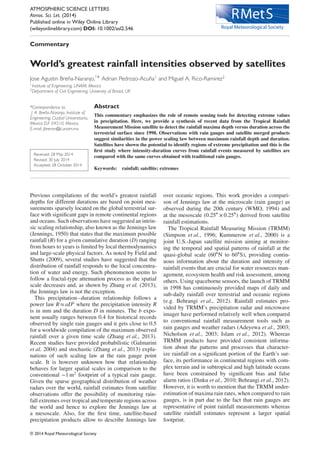
The TMPA 3B42 product was used and analyzed to
obtain a new relationship of worldwide rainfall max-
ima versus duration (see Figure 1). The same figure
shows that mesoscale values never exceed point rainfall
measurements and a Jennings law having an exponent
slightly above 0.4 whereas rainfall events with a cumu-
lative duration of at least two months show an exponent
close to 0.7, leading to a change in the slope of the curve
(unlike the curve from gauge data which displays a con-
stant slope). Although, both fitted values (short and long
cumulative rainfall) are not statistically significant, an
increase in the slope can be inferred as the potential of
passive microwave radiometers to measure rainfall over
large timescales with respect to short timescales. Our
analysis suggests that the 0.25∘ × 0.25∘ satellite-derived
rainfall-duration envelopes are formed of two slopes
with different exponents, for short (<105 min) and long
(>105 min) durations, respectively. It is worth to note
that the “flat” slope observed around 104 min for the
0.25∘ × 0.25∘ envelope (see TRMM dots in Figure 1)
is not observed for coarser resolutions (0.5∘ and 1∘, not
displayed in Figure 1).
Maxima rainfall intensities for larger than
0.25∘ × 0.25∘ resolutions show that rainfall declines as
the spatial scale becomes coarser although not by a fac-
tor of two or three (as it is between 1 m2
and 625 km2
),
but rather than by a factor ranging between ∼2 (for short
durations) and ∼1.1 (for long durations). When the
Jennings law is compared between gauges and 1∘ × 1∘
cells, the difference is never greater than 5 times,
which is less than those reported by a numerical model
Figure 1. Observed terrestrial rainfall extremes at the microscale (rain gauge, <1 m2) and mesoscale (TMPA, ∼625 km2). Point
observations (brown dots) from conventional rain gauge historical records (WMO, 1994) and satellite-based precipitation rate
derived from the TMPA 3B42 product from 1998 to 2013 (blue dots) and for different durations. The rainfall-duration envelopes
are derived by a power law type fitting to the measurements. The monitoring of extreme rainfall intensity using both observational
tools suggests a power law behavior similar to the Jennings law between the cumulative rainfall and its corresponding duration
ranging from 3 h to 2 years. The inner box shows the rain intensity (mm h−1
) for rain gauges and three different spatial resolutions
of TMPA (0.25∘, 0.5∘ and 1∘).
© 2014 Royal Meteorological Society Atmos. Sci. Let. (2014)
- 3. Satellite-based extreme rainfall
Table 1. World’s greatest precipitation totals for different durations as observed by rain gauges (WMO, 1994) and the satellite
rainfall product TMPA 3B42 (0.25∘ resolution).
Rain gaugea TMPA 3B42
Duration Depth (mm) Location Depth (mm) Location
3 h NA Concord, USA 405.9 Mairang, India
4.5 h 782 Smethport, USA NA NA
6 h 840 Muduocaidang, China 445.23 Capalonga, Phillipines
9 h 1 087 Belouve, La Reunion 506.31 Kiinagashima, Japan
10 h 1 400 Muduocaidang, China NA NA
12 h NA NA 606 Mairang, India
15 h NA NA 627 Nongshilong, India
18 h NA NA 645 Mairang, India
18.5 h 1 689 Belouve, La Reunion NA NA
21 h NA NA 763.11 Upolu, Samoa
24 h 1 825 Foc Foc, La Reunion 778.2 Quang Nam, Vietnam
2 days 2 467 Aurere, La Reunion 1 066 Quang Nam, Vietnam
3 days 3 130 Aurere, La Reunion 1 499 Quang Nam, Vietnam
4 days 3 721 Cherrapunji, India 1 569 Quang Nam, Vietnam
5 days 4 301 Commerson, La Reunion 1 729 Quang Nam, Vietnam
6 days 4 653 Commerson, La Reunion 1 734 Quang Nam, Vietnam
7 days 5 003 Commerson, La Reunion 1 736 Quang Nam, Vietnam
8 days 5 286 Commerson, La Reunion 1 736 Quang Nam, Vietnam
9 days 5 692 Commerson, La Reunion 1 766 Quang Nam, Vietnam
10 days 6 028 Commerson, La Reunion 1 809 Sohiong, India
11 days 6 299 Commerson, La Reunion 1 869 Sohiong, India
12 days 6 401 Commerson, La Reunion 2 018 Sohiong, India
13 days 6 422 Commerson, La Reunion 2 339 Sohiong, India
14 days 6 432 Commerson, La Reunion 2 510 Sohiong, India
15 days 6 433 Commerson, La Reunion 2 678 Sohiong, India
31 days 9 300 Cherrapunji, India 3 177 Sohiong, India
2 months 12 767 Cherrapunji, India 3 639 Sohiong, India
3 months 16 369 Cherrapunji, India 4 769 Sohiong, India
4 months 18 738 Cherrapunji, India 5 815 Sohiong, India
5 months 20 412 Cherrapunji, India 6 432 Sohiong, India
6 months 22 454 Cherrapunji, India 7 188 Sohiong, India
11 months 22 990 Cherrapunji, India 10 165 Choco, Colombia
12 months 26 461 Cherrapunji, India 10 849 Choco, Colombia
24 months 40 768 Cherrapunji, India 21 041 Choco, Colombia
a
Data from Jennings (1950) and the World Meteorological Organization (1994).
(Zhang et al., 2013). The fact that extreme rainfall
intensity from gauges can be two to three times greater
than measurements from satellites can be explained by
the poor ability of satellites to capture extreme events
characterized by short-term but heavy rainfall intensity
rates. This is supported by the results shown by Field
and Shutts (2009) suggesting that atmospheric models
able to resolve convection processes tend to simu-
late better high intensity rain events when compared
to satellites. As the TMPA is mainly composed of
non-stationary satellites, it is indeed inevitable to have
coarse resolutions (∼25 km × 25 km) that may not well
capture localized events driven by convective and/or
orographic mechanisms, in comparison with some short
events observed by rain gauges as shown in Table 1.
In order to overcome this gap, other measurements
tools such as radars could substantially help to address
extreme rainfall for scales ranging between 1 m2
and
625 km2. However, so far this is only possible in regions
and countries with a robust spatial coverage. Since
many regions of the world (Latin America, Africa,
and Asia) still mainly rely on rain gauges, a global
assessment of the greatest rainfall intensities at inter-
mediate spatial scales using observational data from
radars is not yet possible. Other alternatives include
the recently launched Global Precipitation Measure-
ment (GPM) mission that will retrieve rainfall rates esti-
mates at a much finer scale (5 km) and hence likely
to capture extreme rainfall (resulting from local pre-
cipitation systems) more easily than most of the cur-
rent remote sensing tools do at coarser resolution.
Our TMPA derived analysis also confirms the exis-
tence of well-known regions of extreme wetness over
multi-weekly and multi-monthly timescales such as
Northeast India and Colombia’s Pacific coast and for
detecting hotspots of extreme rainfall intensity such
as Vietnam’s coast, among others (see Table 1). Note
that for such long durations (months to years), it is the
high frequency of events characterized by milder rain
intensity rates that commonly occur in places such as
Cherrapunji (India) and Chocó (Colombia) that could
potentially explain the convergence of rain intensity val-
ues, despite the spatial aggregation of the TMPA prod-
uct as shown in the inner box of Figure 1.
© 2014 Royal Meteorological Society Atmos. Sci. Let. (2014)
- 4. A. Breña-Naranjo, A. Pedrozo-Acuña and M. A. Rico-Ramirez
Figure 2. Spatial distribution of maxima rainfall for 1 day (top left), 7 days (top right), 31 days (bottom left) and 180 days (bottom
right) over the world’s terrestrial surface from 1998 until 2013. This figure clearly shows the potential of the TMPA 3B42 (at a 0.25∘
resolution) product in helping to detect regions with substantial rainfall intensity rates and the concentration of maxima rainfall
in specific regions to as duration increases. For instance, the multiple hundreds of locations where maxima rainfall in 1 day occur
(top left) steadily decreases with time. Cumulative rainfall in 180 days is only found in a few locations mainly in tropical coastal and
mountainous regions.
Finally, the potential of using satellite remote sens-
ing to capture the space-time footprint of maxima
daily rainfall is revealed in Figure 2 as fewer loca-
tions experience substantial rainfall depths as the dura-
tion increases. Although we agree that both types of
data sources are subjected to error measurements, espe-
cially when dealing with extreme events, it is diffi-
cult to assign statistical uncertainties to the Jennings
law, either at the point or mesoscale. We concur how-
ever that the uncertainty is likely to be substantially
higher for short-term durations that for long term cumu-
lative values as suggested by several experimental stud-
ies (Nespor and Sevruk, 1999; Habib et al., 2001). The
role of satellite-based precipitation datasets can provide
insights about the extremeness of rainfall by detecting
the location, amount, duration and clustering of max-
ima precipitation events at a relatively fine scale. More-
over, because of the expected increase of precipitation
frequency and intensity in wet regions during this cen-
tury due to climate change (Sun et al., 2007; Toreti
et al., 2013), the atmospheric science community would
greatly benefit from periodical assessments showing the
variability and persistence of extreme spatiotemporal
states of the atmosphere such as the Jennings law.
Acknowledgements
The TMPA 3B43 Version 7 data were obtained online from
the Mirador Earth Science Search Tool http://mirador.gsfc.nasa.
gov/. Rain gauge data were provided by the guide for hydrologi-
cal practices 5th edition from the World Meteorological Organi-
zation (WMO). We are grateful to Chris Westbrook for providing
helpful comments that improved the quality of this article.
References
Adeyewa Z, Debo , Nakamura K. 2003. Validation of TRMM radar
rainfall data over major climatic regions in Africa. Journal of Applied
Meteorology 42: 331–347, doi: 10.1175/1520-0450(2003)042<
0331:VOTRRD>2.0.CO;2.
Behrangi A, Lebsock M, Wong S, Lambrigtsen B. 2012. On the
quantification of oceanic rainfall using spaceborne sensors. Jour-
nal of Geophysical Research 117: D20105, doi: 10.1029/2012JD
017979.
Dinku T, Connor SJ, Ceccato P. 2010. Comparison of CMORPH
and TRMM-3B42 over mountainous regions of Africa and South
America. In Satellite Rainfall Applications for Surface Hydrology,
Gebremichael M, Hossain F (eds). Springer-Verlag: Dordrecht,
Netherlands; 193–204.
Field PR, Shutts GJ. 2009. Properties of normalized rain-rate distribu-
tions in the tropical Pacific. Quarterly Journal of the Royal Meteoro-
logical Society 135: 175–186.
Galmarini S, Steyn DG, Ainslie B. 2004. The scaling law relating
world point-precipitation records to duration. International Journal
of Climatology 24: 533–546, doi: 10.1002/joc.1022.
Habib E, Krajewski WF, Kruger A. 2001. Sampling errors of fine resolu-
tion tipping-bucket rain gauge measurements. Journal of Hydrological
Engineering 6(2): 159–166.
Huffman GJ, Adler RF, Bolvin DT, Gu G, Nelkin EJ, Bowman KP, Hong
Y, Stocker EF, Wolff DB. 2007. The TRMM multisatellite precip-
itation analysis (TMPA): Quasi-global, multiyear, combined-sensor
precipitation estimates at fine scales. Journal of Hydrometeorology 8:
38–55.
Islam T, Rico-Ramirez MA, Han D, Srivastava PK, Ishak AM. 2012.
Performance evaluation of the TRMM precipitation estimation using
ground-based radars from the GPM validation network. Journal
of Atmospheric and Solar-Terrestrial Physics 77: 194–208, doi:
10.1016/j.jastp.2012.01.001.
Jennings AH. 1950. World’s greatest observed point rainfalls. Monthly
Weather Review 78(1): 4–5.
Kummerow C, Simpson J, Thiele O, Barnes W, Chang ATC, Stocker
E, Adler RF, Hou A, Kakar R, Wentz F, Ashcroft P, Kozu T, Hong
Y, Okamoto K, Iguchi T, Kuroiwa H, Im E, Haddad Z, Huffman
G, Ferrier B, Olson WS, Zipser E, Smith EA, Wilheit TT, North
G, Krishnamurti T, Nakamura K. 2000. The status of the Tropical
Rainfall Measuring Mission (TRMM) after two years in orbit. Journal
of Applied Meteorology 39: 1965–1982.
Nespor V, Sevruk B. 1999. Estimation of wind-induced error of rainfall
gauge measurements using a numerical simulation. Journal of Atmo-
spheric and Oceanic Technology 16: 450–464.
Nicholson S, Some B, McCollum J, Nelkin E, Klotter D, Berte Y, Diallo
BM, Gaye I, Kpabeba G, Ndiaye O, Noukpozounkou JN, Tanu MM,
Thiam A, Toure AA, Traore AK. 2003. Validation of TRMM and other
rainfall estimates with a high-density gauge dataset for West Africa.
Part II: Validation of TRMM rainfall products. Journal of Applied
Meteorology 42: 1355–1368.
O’Gorman PA. 2012. Sensitivity of tropical precipitation extremes to
climate change. Nature Geoscience 5: 697–700.
© 2014 Royal Meteorological Society Atmos. Sci. Let. (2014)
- 5. Satellite-based extreme rainfall
Simpson J, Kummerov C, Tao W-K, Adler RF. 1996. On the Tropical
Rainfall Measuring Mission (TRMM). Meteorology and Atmospheric
Physics 60: 19–36.
Sun Y, Solomon S, Dai A, Portmann R. 2007. How often will it rain?
Journal of Climate 20: 4801–4818.
Toreti A, Naveau P, Zampieri M, Schindler A, Scoccimarro E, Xoplaki
E, Dijkstra HA, Gualdi S, Luterbacher J. 2013. Projections of global
changes in precipitation extremes from Coupled Model Intercom-
parison Project Phase 5 models. Geophysical Research Letters 40:
4887–4892, doi: 10.1002/grl.50940.
Wilcox EM, Donner LJ. 2007. The frequency of extreme rain events
in satellite rain-rate estimates and an atmospheric general circulation
model. Journal of Climate 20: 53–69.
World Meteorological Organization. 1994. Guide to Hydrologi-
cal Practices, 5th ed. WMO 168, WMO: Geneva, Switzerland;
402 pp.
Zhang H, Fraedrich K, Zhu X, Blender R, Zhang L. 2013. World’s
Greatest Observed Point Rainfalls: Jennings (1950) Scaling Law.
Journal of Hydrometeorology 14: 1952–1957, doi: 10.1175/JHM-D-
13-074.1.
© 2014 Royal Meteorological Society Atmos. Sci. Let. (2014)