SlideShare ist ein Scribd-Unternehmen logo
1 von 1
Mariah L. Danner, Michael D. Turzewski, Katherine W. Huntington
Abstract
Background
Methods Model Comparison
Conclusions
References
Infrequent high-magnitude releases of water, known as outburst floods, are important to understand
due to their hazard to humans and property, as well as their role in shaping landscapes. This
importance increases as outburst floods become more frequent in mountainous regions due to climate
change and glacial melting, yet numerical models which simulate flood hydraulics and predict hazard
haven’t been rigorously evaluated in mountainous terrain. The 2000 Yigong dam-break-flood in the
Eastern Himalaya is the largest, best documented opportunity to ground truth flood simulations with
observations. In this study the trimline, flood high water marks, were mapped to compare to the
inundation of Yigong flood simulated using 2D shallow water numerical model. Trimline position was
identified by vegetation change determined by two kinds of remote sensing data, GoogleEarth imagery
and Landsat imagery. The GoogleEarth imagery was used in the Indian region of the river-gorge, with a
total distance of 564m of trimline being confidently mapped. Results from the data gained overlaid with
the flood model show well defined trimline matching the model predictions. The GoogleEarth imagery
also showed landslides triggered by the flood, indicating spatial distribution of erosion and landscape
modification caused by the flood. Preliminary analysis of 2001 Landsat 7 imagery suggests better
resolution and location accuracy than GoogleEarth, particularly in the Northern region of the study
area. The most notable benefit of Landsat analysis is quantitatively isolating vegetation change using
specific band widths, thus eliminating subjective interpretation of imagery by the analyst. The good
match of mapped trimlines and simulated high water marks validates the numerical model in this
region. Our results suggest this modeling approach is promising and applicable to evaluating the impact
of floods on hazard and landscape change in other mountainous regions.
Delaney, Keith B, Evans, Stephen G. “Characterization of the 2000 Yigong Zangbo River (Tibet)
Landslide Dam and Impoundment by Remote Sensing” (2001): 543-559
Larsen, Isaac J, Montgomery, David R. “Landslide erosion coupled to tectonics and river
incision” (2012): Nature: Geoscience : 468-473
Vegetation change designates trim line in imagery. Dense, sal rich vegetation is
old growth; sparse bamboo is the 2000 flood trim line; bare rock is usually (but
not exclusively) seasonal monsoon flow trim line.
Boleng – Mopit (Tibet) Nubo Bridge, Yingkiong (Tibet)
Pailongcun (Tibet) Tuting (Tibet)
South Pailongcun (Tibet)
Hydrograph at Nubo Bridge Hydrograph at Tuting
Inundation at Nubo Bridge Inundation at Tuting
Google Earth Mapping:
Landsat 7 Raster Mapping:
Landsat 7 Landslide Mapping:
• Evaluating the accuracy of a
GeoClaw numerical flood
model
• High relief topographic regions
(gorges) lack accurate models
• Mapping high water marks
caused by the 2000 Yigong
River Landslide dam failure
• Vegetation change marked
trim line in remote sensing
data
• Mapping erosion caused by
flood through landslides
• Background flood information:
o Landslide in 2000
dammed Yigong Zangbo
River
o Dam lasted 62 days
o Max volume of lake
roughly 3 cubic km
o Flood occurred June 10,
2000
Tectonics & Erosion Lab, Earth and Space Sciences mariad11@uw.edu – kate1@uw.edu – zewski@uw.edu
• Total distance of mapped trim line is roughly 4 km located south of
India/China border
• Mapping was done using current and historical Google Earth Imagery
• Projection source of imagery sometimes unknown/unclear. This caused
error in simulation comparison.
• Total distance of mapped trim line roughly 172 km located from source
lake to Tuting
• Imagery from March 2001, roughly 4 months after flood
• High resolution imagery in Yigong gorge enables accurate mapping
• All imagery in WGS 1984 projection – no comparison error with simulation
• Mapped on WGS 1984 DEM using
ArcGIS
• Ten large scale landslides mapped in
northern gorge
• Landslides mapped cover 38.81km
from the source lake south past
Pailongcun
• Pre-flood imagery was compared to
DEM to ensure landslides occurred
after flood event
• High relief, sinuous portions of the
gorge were too shaded in the DEM
to accurately map landslides in
portions of gorge
• Future work will increase landslide
mapping downstream of Pailongcun
• Simulation was created in GeoClaw using an inverted tsunami model
• 14 gauges within simulation located at specific places (Tangmai, Tuting,
Nubo Bridge etc.) record water depth and velocities throughout model
flood duration
• Inundation was modeled on a DEM with trimlines being added on later
• Based upon measured depth of flow in the simulation in comparison to
elevation of mapped trim line, the model is accurate with minimal error
• Comprehensive analysis must be done with full Landsat 7 data for
completely accurate comparison
• Future work – remap south of Tuting along entire river using Landsat 7
imagery
• Future work – use raster analysis using ENVI to isolate mineral and
vegetation changes automatically using non-visible spectrum to reduce
analyst error
• Landslides equaled 2.94 sq. miles of erosion over a 38.81km segment of the
river
• Average discharge equaled 47,000 cubic m/s in gorge
• Future work – map landslides further downstream as far as possible
• Future work – use raster analysis (ENVI) to isolate landslides within DEM
Model evaluation:
Estimate of landslide induced erosion:

Weitere ähnliche Inhalte

Was ist angesagt?

IGARSS2011_DInSAR_MORRISON.ppt
IGARSS2011_DInSAR_MORRISON.pptIGARSS2011_DInSAR_MORRISON.ppt
IGARSS2011_DInSAR_MORRISON.pptgrssieee
 
IUKWC Workshop Nov16: Developing Hydro-climatic Services for Water Security –...
IUKWC Workshop Nov16: Developing Hydro-climatic Services for Water Security –...IUKWC Workshop Nov16: Developing Hydro-climatic Services for Water Security –...
IUKWC Workshop Nov16: Developing Hydro-climatic Services for Water Security –...India UK Water Centre (IUKWC)
 
Fractal Geometry of Landslide Zones
Fractal Geometry of Landslide ZonesFractal Geometry of Landslide Zones
Fractal Geometry of Landslide ZonesAli Osman Öncel
 
CLIMATE CHANGE IMPACT ASSESSMENT ON MELTING GLACIERS USING RS & GIS
CLIMATE CHANGE IMPACT ASSESSMENT ON MELTING GLACIERS USING RS & GISCLIMATE CHANGE IMPACT ASSESSMENT ON MELTING GLACIERS USING RS & GIS
CLIMATE CHANGE IMPACT ASSESSMENT ON MELTING GLACIERS USING RS & GISAbhiram Kanigolla
 
SURE2011_Civil_TruongNicolas
SURE2011_Civil_TruongNicolasSURE2011_Civil_TruongNicolas
SURE2011_Civil_TruongNicolasNicolas Truong
 
Presentation: Unit 2 Measuring Groundwater Background Information
Presentation: Unit 2 Measuring Groundwater Background InformationPresentation: Unit 2 Measuring Groundwater Background Information
Presentation: Unit 2 Measuring Groundwater Background InformationSERC at Carleton College
 
Measuring Ice Mass Loss from Melting Ice Sheets
Measuring Ice Mass Loss from Melting Ice SheetsMeasuring Ice Mass Loss from Melting Ice Sheets
Measuring Ice Mass Loss from Melting Ice SheetsChristopher Harig
 
Gravity & magnetic methods in geology
Gravity & magnetic methods in geologyGravity & magnetic methods in geology
Gravity & magnetic methods in geologyMd Asif Hasan
 
Modeling the Effects of Land Use Change on Flooding
Modeling the Effects of Land Use Change on FloodingModeling the Effects of Land Use Change on Flooding
Modeling the Effects of Land Use Change on FloodingAdam Nayak
 
Geomorphology applications
Geomorphology applicationsGeomorphology applications
Geomorphology applicationsvyshalik
 
ÖNCEL AKADEMİ: INTRODUCTION TO GEOPHYSICS
ÖNCEL AKADEMİ: INTRODUCTION TO GEOPHYSICSÖNCEL AKADEMİ: INTRODUCTION TO GEOPHYSICS
ÖNCEL AKADEMİ: INTRODUCTION TO GEOPHYSICSAli Osman Öncel
 
Monitoring ocean currents using satellite sensors
Monitoring ocean currents using satellite sensorsMonitoring ocean currents using satellite sensors
Monitoring ocean currents using satellite sensorsbealberith
 
jennifer_digiulio_56x36in_poster
jennifer_digiulio_56x36in_posterjennifer_digiulio_56x36in_poster
jennifer_digiulio_56x36in_posterJennifer DiGiulio
 

Was ist angesagt? (19)

Mercator Ocean newsletter 25
Mercator Ocean newsletter 25Mercator Ocean newsletter 25
Mercator Ocean newsletter 25
 
IGARSS2011_DInSAR_MORRISON.ppt
IGARSS2011_DInSAR_MORRISON.pptIGARSS2011_DInSAR_MORRISON.ppt
IGARSS2011_DInSAR_MORRISON.ppt
 
IUKWC Workshop Nov16: Developing Hydro-climatic Services for Water Security –...
IUKWC Workshop Nov16: Developing Hydro-climatic Services for Water Security –...IUKWC Workshop Nov16: Developing Hydro-climatic Services for Water Security –...
IUKWC Workshop Nov16: Developing Hydro-climatic Services for Water Security –...
 
5.2.1 Lecture - Spatial Scales
5.2.1 Lecture - Spatial Scales5.2.1 Lecture - Spatial Scales
5.2.1 Lecture - Spatial Scales
 
Fractal Geometry of Landslide Zones
Fractal Geometry of Landslide ZonesFractal Geometry of Landslide Zones
Fractal Geometry of Landslide Zones
 
CLIMATE CHANGE IMPACT ASSESSMENT ON MELTING GLACIERS USING RS & GIS
CLIMATE CHANGE IMPACT ASSESSMENT ON MELTING GLACIERS USING RS & GISCLIMATE CHANGE IMPACT ASSESSMENT ON MELTING GLACIERS USING RS & GIS
CLIMATE CHANGE IMPACT ASSESSMENT ON MELTING GLACIERS USING RS & GIS
 
SURE2011_Civil_TruongNicolas
SURE2011_Civil_TruongNicolasSURE2011_Civil_TruongNicolas
SURE2011_Civil_TruongNicolas
 
GIS Expo 2014: Nearshore Depth Derivation Using World View-2 Multispectral Sa...
GIS Expo 2014: Nearshore Depth Derivation Using World View-2 Multispectral Sa...GIS Expo 2014: Nearshore Depth Derivation Using World View-2 Multispectral Sa...
GIS Expo 2014: Nearshore Depth Derivation Using World View-2 Multispectral Sa...
 
Presentation: Unit 2 Measuring Groundwater Background Information
Presentation: Unit 2 Measuring Groundwater Background InformationPresentation: Unit 2 Measuring Groundwater Background Information
Presentation: Unit 2 Measuring Groundwater Background Information
 
Measuring Ice Mass Loss from Melting Ice Sheets
Measuring Ice Mass Loss from Melting Ice SheetsMeasuring Ice Mass Loss from Melting Ice Sheets
Measuring Ice Mass Loss from Melting Ice Sheets
 
Gravity & magnetic methods in geology
Gravity & magnetic methods in geologyGravity & magnetic methods in geology
Gravity & magnetic methods in geology
 
Modeling the Effects of Land Use Change on Flooding
Modeling the Effects of Land Use Change on FloodingModeling the Effects of Land Use Change on Flooding
Modeling the Effects of Land Use Change on Flooding
 
Geomorphology applications
Geomorphology applicationsGeomorphology applications
Geomorphology applications
 
ÖNCEL AKADEMİ: INTRODUCTION TO GEOPHYSICS
ÖNCEL AKADEMİ: INTRODUCTION TO GEOPHYSICSÖNCEL AKADEMİ: INTRODUCTION TO GEOPHYSICS
ÖNCEL AKADEMİ: INTRODUCTION TO GEOPHYSICS
 
final_paper1
final_paper1final_paper1
final_paper1
 
Monitoring ocean currents using satellite sensors
Monitoring ocean currents using satellite sensorsMonitoring ocean currents using satellite sensors
Monitoring ocean currents using satellite sensors
 
Gravity method
Gravity methodGravity method
Gravity method
 
July 30-210-Ann Marie Fortuna
July 30-210-Ann Marie FortunaJuly 30-210-Ann Marie Fortuna
July 30-210-Ann Marie Fortuna
 
jennifer_digiulio_56x36in_poster
jennifer_digiulio_56x36in_posterjennifer_digiulio_56x36in_poster
jennifer_digiulio_56x36in_poster
 

Ähnlich wie symposiumposter2015

Geohydrological study of weathered basement aquifers in Oban Massif and envir...
Geohydrological study of weathered basement aquifers in Oban Massif and envir...Geohydrological study of weathered basement aquifers in Oban Massif and envir...
Geohydrological study of weathered basement aquifers in Oban Massif and envir...iosrjce
 
REMOTE SENSING DATA FOR HYDROLOGICAL MODELING
REMOTE SENSING DATA FOR HYDROLOGICAL MODELINGREMOTE SENSING DATA FOR HYDROLOGICAL MODELING
REMOTE SENSING DATA FOR HYDROLOGICAL MODELINGShyam Mohan Chaudhary
 
Evaluation of morphometric parameters derived from Cartosat-1 DEM using remot...
Evaluation of morphometric parameters derived from Cartosat-1 DEM using remot...Evaluation of morphometric parameters derived from Cartosat-1 DEM using remot...
Evaluation of morphometric parameters derived from Cartosat-1 DEM using remot...Dr Ramesh Dikpal
 
identification of ground water potential zones using gis and remote sensing
identification of ground water potential zones using gis and remote sensingidentification of ground water potential zones using gis and remote sensing
identification of ground water potential zones using gis and remote sensingtp jayamohan
 
Hydrological Application of Remote – Sensing and GIS for Handling of Excess R...
Hydrological Application of Remote – Sensing and GIS for Handling of Excess R...Hydrological Application of Remote – Sensing and GIS for Handling of Excess R...
Hydrological Application of Remote – Sensing and GIS for Handling of Excess R...IDES Editor
 
Farms, Floods And Fluvial Geomorphology: Making The Most of Our Natural Resou...
Farms, Floods And Fluvial Geomorphology: Making The Most of Our Natural Resou...Farms, Floods And Fluvial Geomorphology: Making The Most of Our Natural Resou...
Farms, Floods And Fluvial Geomorphology: Making The Most of Our Natural Resou...National Institute of Food and Agriculture
 
Detection of hazard prone areas in the upper himalayan region in gis environment
Detection of hazard prone areas in the upper himalayan region in gis environmentDetection of hazard prone areas in the upper himalayan region in gis environment
Detection of hazard prone areas in the upper himalayan region in gis environmenteSAT Publishing House
 
Coupling of Surface water and Groundwater Models
Coupling of Surface water and Groundwater Models Coupling of Surface water and Groundwater Models
Coupling of Surface water and Groundwater Models TIPU SULTAN BADAGAN
 
Potential Recharge Zones.pptx
Potential Recharge Zones.pptxPotential Recharge Zones.pptx
Potential Recharge Zones.pptxQasimHaider4
 
measures to counteract urban floods
measures to counteract urban floodsmeasures to counteract urban floods
measures to counteract urban floodsdontknow288849
 
final project ppt (2).ppt
final project ppt (2).pptfinal project ppt (2).ppt
final project ppt (2).pptdontknow288849
 
Preparation of flood risk and vulnerability map final report ktm sept_17
Preparation of flood risk and vulnerability map final report ktm sept_17Preparation of flood risk and vulnerability map final report ktm sept_17
Preparation of flood risk and vulnerability map final report ktm sept_17DPNet
 
A REVIEW ON RESERVOIR SEDIMENTATION STUDIES USING SATELLITE REMOTE SENSING TE...
A REVIEW ON RESERVOIR SEDIMENTATION STUDIES USING SATELLITE REMOTE SENSING TE...A REVIEW ON RESERVOIR SEDIMENTATION STUDIES USING SATELLITE REMOTE SENSING TE...
A REVIEW ON RESERVOIR SEDIMENTATION STUDIES USING SATELLITE REMOTE SENSING TE...ijiert bestjournal
 
DSD-INT 2014 - Symposium Next Generation Hydro Software (NGHS) - 2D hydrodyna...
DSD-INT 2014 - Symposium Next Generation Hydro Software (NGHS) - 2D hydrodyna...DSD-INT 2014 - Symposium Next Generation Hydro Software (NGHS) - 2D hydrodyna...
DSD-INT 2014 - Symposium Next Generation Hydro Software (NGHS) - 2D hydrodyna...Deltares
 
StreamFlow Variability of 21 Watersheds, Oregon
StreamFlow Variability of 21 Watersheds, OregonStreamFlow Variability of 21 Watersheds, Oregon
StreamFlow Variability of 21 Watersheds, OregonDonnych Diaz
 
The stream power variation in a GIS environment as an index to evaluate the m...
The stream power variation in a GIS environment as an index to evaluate the m...The stream power variation in a GIS environment as an index to evaluate the m...
The stream power variation in a GIS environment as an index to evaluate the m...pierluigi de rosa
 

Ähnlich wie symposiumposter2015 (20)

Geohydrological study of weathered basement aquifers in Oban Massif and envir...
Geohydrological study of weathered basement aquifers in Oban Massif and envir...Geohydrological study of weathered basement aquifers in Oban Massif and envir...
Geohydrological study of weathered basement aquifers in Oban Massif and envir...
 
REMOTE SENSING DATA FOR HYDROLOGICAL MODELING
REMOTE SENSING DATA FOR HYDROLOGICAL MODELINGREMOTE SENSING DATA FOR HYDROLOGICAL MODELING
REMOTE SENSING DATA FOR HYDROLOGICAL MODELING
 
Evaluation of morphometric parameters derived from Cartosat-1 DEM using remot...
Evaluation of morphometric parameters derived from Cartosat-1 DEM using remot...Evaluation of morphometric parameters derived from Cartosat-1 DEM using remot...
Evaluation of morphometric parameters derived from Cartosat-1 DEM using remot...
 
identification of ground water potential zones using gis and remote sensing
identification of ground water potential zones using gis and remote sensingidentification of ground water potential zones using gis and remote sensing
identification of ground water potential zones using gis and remote sensing
 
Hydrological Application of Remote – Sensing and GIS for Handling of Excess R...
Hydrological Application of Remote – Sensing and GIS for Handling of Excess R...Hydrological Application of Remote – Sensing and GIS for Handling of Excess R...
Hydrological Application of Remote – Sensing and GIS for Handling of Excess R...
 
Farms, Floods And Fluvial Geomorphology: Making The Most of Our Natural Resou...
Farms, Floods And Fluvial Geomorphology: Making The Most of Our Natural Resou...Farms, Floods And Fluvial Geomorphology: Making The Most of Our Natural Resou...
Farms, Floods And Fluvial Geomorphology: Making The Most of Our Natural Resou...
 
Detection of hazard prone areas in the upper himalayan region in gis environment
Detection of hazard prone areas in the upper himalayan region in gis environmentDetection of hazard prone areas in the upper himalayan region in gis environment
Detection of hazard prone areas in the upper himalayan region in gis environment
 
Coupling of Surface water and Groundwater Models
Coupling of Surface water and Groundwater Models Coupling of Surface water and Groundwater Models
Coupling of Surface water and Groundwater Models
 
Applicability Study on the Optical Remote Sensing Techniques in a River
Applicability Study on the Optical Remote Sensing Techniques in a RiverApplicability Study on the Optical Remote Sensing Techniques in a River
Applicability Study on the Optical Remote Sensing Techniques in a River
 
Potential Recharge Zones.pptx
Potential Recharge Zones.pptxPotential Recharge Zones.pptx
Potential Recharge Zones.pptx
 
measures to counteract urban floods
measures to counteract urban floodsmeasures to counteract urban floods
measures to counteract urban floods
 
Alberto Bellin
Alberto BellinAlberto Bellin
Alberto Bellin
 
final project ppt (2).ppt
final project ppt (2).pptfinal project ppt (2).ppt
final project ppt (2).ppt
 
Preparation of flood risk and vulnerability map final report ktm sept_17
Preparation of flood risk and vulnerability map final report ktm sept_17Preparation of flood risk and vulnerability map final report ktm sept_17
Preparation of flood risk and vulnerability map final report ktm sept_17
 
Online Watershed Analysis Tool
Online Watershed Analysis Tool Online Watershed Analysis Tool
Online Watershed Analysis Tool
 
Minsley et al 2011 - JEEG
Minsley et al 2011 - JEEGMinsley et al 2011 - JEEG
Minsley et al 2011 - JEEG
 
A REVIEW ON RESERVOIR SEDIMENTATION STUDIES USING SATELLITE REMOTE SENSING TE...
A REVIEW ON RESERVOIR SEDIMENTATION STUDIES USING SATELLITE REMOTE SENSING TE...A REVIEW ON RESERVOIR SEDIMENTATION STUDIES USING SATELLITE REMOTE SENSING TE...
A REVIEW ON RESERVOIR SEDIMENTATION STUDIES USING SATELLITE REMOTE SENSING TE...
 
DSD-INT 2014 - Symposium Next Generation Hydro Software (NGHS) - 2D hydrodyna...
DSD-INT 2014 - Symposium Next Generation Hydro Software (NGHS) - 2D hydrodyna...DSD-INT 2014 - Symposium Next Generation Hydro Software (NGHS) - 2D hydrodyna...
DSD-INT 2014 - Symposium Next Generation Hydro Software (NGHS) - 2D hydrodyna...
 
StreamFlow Variability of 21 Watersheds, Oregon
StreamFlow Variability of 21 Watersheds, OregonStreamFlow Variability of 21 Watersheds, Oregon
StreamFlow Variability of 21 Watersheds, Oregon
 
The stream power variation in a GIS environment as an index to evaluate the m...
The stream power variation in a GIS environment as an index to evaluate the m...The stream power variation in a GIS environment as an index to evaluate the m...
The stream power variation in a GIS environment as an index to evaluate the m...
 

symposiumposter2015

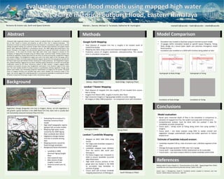
  • 1. Mariah L. Danner, Michael D. Turzewski, Katherine W. Huntington Abstract Background Methods Model Comparison Conclusions References Infrequent high-magnitude releases of water, known as outburst floods, are important to understand due to their hazard to humans and property, as well as their role in shaping landscapes. This importance increases as outburst floods become more frequent in mountainous regions due to climate change and glacial melting, yet numerical models which simulate flood hydraulics and predict hazard haven’t been rigorously evaluated in mountainous terrain. The 2000 Yigong dam-break-flood in the Eastern Himalaya is the largest, best documented opportunity to ground truth flood simulations with observations. In this study the trimline, flood high water marks, were mapped to compare to the inundation of Yigong flood simulated using 2D shallow water numerical model. Trimline position was identified by vegetation change determined by two kinds of remote sensing data, GoogleEarth imagery and Landsat imagery. The GoogleEarth imagery was used in the Indian region of the river-gorge, with a total distance of 564m of trimline being confidently mapped. Results from the data gained overlaid with the flood model show well defined trimline matching the model predictions. The GoogleEarth imagery also showed landslides triggered by the flood, indicating spatial distribution of erosion and landscape modification caused by the flood. Preliminary analysis of 2001 Landsat 7 imagery suggests better resolution and location accuracy than GoogleEarth, particularly in the Northern region of the study area. The most notable benefit of Landsat analysis is quantitatively isolating vegetation change using specific band widths, thus eliminating subjective interpretation of imagery by the analyst. The good match of mapped trimlines and simulated high water marks validates the numerical model in this region. Our results suggest this modeling approach is promising and applicable to evaluating the impact of floods on hazard and landscape change in other mountainous regions. Delaney, Keith B, Evans, Stephen G. “Characterization of the 2000 Yigong Zangbo River (Tibet) Landslide Dam and Impoundment by Remote Sensing” (2001): 543-559 Larsen, Isaac J, Montgomery, David R. “Landslide erosion coupled to tectonics and river incision” (2012): Nature: Geoscience : 468-473 Vegetation change designates trim line in imagery. Dense, sal rich vegetation is old growth; sparse bamboo is the 2000 flood trim line; bare rock is usually (but not exclusively) seasonal monsoon flow trim line. Boleng – Mopit (Tibet) Nubo Bridge, Yingkiong (Tibet) Pailongcun (Tibet) Tuting (Tibet) South Pailongcun (Tibet) Hydrograph at Nubo Bridge Hydrograph at Tuting Inundation at Nubo Bridge Inundation at Tuting Google Earth Mapping: Landsat 7 Raster Mapping: Landsat 7 Landslide Mapping: • Evaluating the accuracy of a GeoClaw numerical flood model • High relief topographic regions (gorges) lack accurate models • Mapping high water marks caused by the 2000 Yigong River Landslide dam failure • Vegetation change marked trim line in remote sensing data • Mapping erosion caused by flood through landslides • Background flood information: o Landslide in 2000 dammed Yigong Zangbo River o Dam lasted 62 days o Max volume of lake roughly 3 cubic km o Flood occurred June 10, 2000 Tectonics & Erosion Lab, Earth and Space Sciences mariad11@uw.edu – kate1@uw.edu – zewski@uw.edu • Total distance of mapped trim line is roughly 4 km located south of India/China border • Mapping was done using current and historical Google Earth Imagery • Projection source of imagery sometimes unknown/unclear. This caused error in simulation comparison. • Total distance of mapped trim line roughly 172 km located from source lake to Tuting • Imagery from March 2001, roughly 4 months after flood • High resolution imagery in Yigong gorge enables accurate mapping • All imagery in WGS 1984 projection – no comparison error with simulation • Mapped on WGS 1984 DEM using ArcGIS • Ten large scale landslides mapped in northern gorge • Landslides mapped cover 38.81km from the source lake south past Pailongcun • Pre-flood imagery was compared to DEM to ensure landslides occurred after flood event • High relief, sinuous portions of the gorge were too shaded in the DEM to accurately map landslides in portions of gorge • Future work will increase landslide mapping downstream of Pailongcun • Simulation was created in GeoClaw using an inverted tsunami model • 14 gauges within simulation located at specific places (Tangmai, Tuting, Nubo Bridge etc.) record water depth and velocities throughout model flood duration • Inundation was modeled on a DEM with trimlines being added on later • Based upon measured depth of flow in the simulation in comparison to elevation of mapped trim line, the model is accurate with minimal error • Comprehensive analysis must be done with full Landsat 7 data for completely accurate comparison • Future work – remap south of Tuting along entire river using Landsat 7 imagery • Future work – use raster analysis using ENVI to isolate mineral and vegetation changes automatically using non-visible spectrum to reduce analyst error • Landslides equaled 2.94 sq. miles of erosion over a 38.81km segment of the river • Average discharge equaled 47,000 cubic m/s in gorge • Future work – map landslides further downstream as far as possible • Future work – use raster analysis (ENVI) to isolate landslides within DEM Model evaluation: Estimate of landslide induced erosion: