East Anglia - our region
•
1 gefällt mir•4,968 views

A powerpoint created for a lesson on East Anglia.

Empfohlen
Weitere ähnliche Inhalte
Was ist angesagt?
Ähnlich wie East Anglia - our region
Mehr von S Rackley
Mehr von S Rackley (20)
Kürzlich hochgeladen
Kürzlich hochgeladen (20)
East Anglia - our region
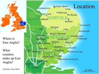
- 1. Location Where is East Anglia? What counties make up East Anglia? S.Rackley (Sep 2005)
- 2. The Romans!
- 3. Glaciation!
- 7. Towns Norwich Ipswich King’s Lynn Yarmouth Lowestoft Harwich Felixstowe
- 8. East Anglia Map Use an atlas to mark on your map: ATLASES: PAGE 25 Rivers: Great Ouse Yare Wensum (Orwell) Towns: Norwich Ipswich Gt. Yarmouth Lowstoft King’s Lynn Thetford Colchester (Southend) Features: The Broads Breckland The Fens Water: North Sea The Wash Counties: Norfolk Suffolk Essex Services: Stansted Airport Felixstowe (Harwich)
- 9. The Fens This is a very different area and is found in the _____ of the region. It is very _____, mostly less than __ meters above sea level. The area used to be a large ______, with many _______ running through it. These have now been altered and many new __________ built. This helps the area to be ________. The roads in the area are very ________. The land in this area is now mainly used for ________, the main products being ___________ and ____________. Broadland This is another very _____ area, that contains many ______ and ______. The landscape has been altered by ____ over many years. The lakes were ____ by man for _____ in the middle ages for ____. Many people come here for ________. The area is now a ________ park, where the landscape is ___________. This brings _______ and ________ to the area. west flat 6 marsh rivers waterways drained straight farming vegetables flowers flat rivers lakes man dug peat fuel holidays national preserved benefits problems
- 10. Breckland This area is found on the ________ - ________ border. It has very _____ soils which means that naturally it would be _________. Today much of the area is used for _________ and __________ training. It is also a very flat area. The towns of ________ and _______ are found here. Norfolk Suffolk poor heathland forestry military Brandon Thetford
- 11. Describe East Anglia’s climate! (Say two things about it’s temperature and two things about it’s rainfall. Try to use figures!