Surveying ii ajith sir class4
•Als PPT, PDF herunterladen•
8 gefällt mir•1,071 views

GCE Kannur

Empfohlen
Weitere ähnliche Inhalte
Was ist angesagt?
Was ist angesagt? (20)
Andere mochten auch
Andere mochten auch (10)
Ähnlich wie Surveying ii ajith sir class4
Ähnlich wie Surveying ii ajith sir class4 (20)
Mehr von SHAMJITH KM
Mehr von SHAMJITH KM (20)
Kürzlich hochgeladen
Kürzlich hochgeladen (20)
Surveying ii ajith sir class4
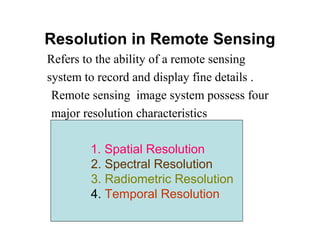
- 1. Resolution in Remote Sensing Refers to the ability of a remote sensing system to record and display fine details . Remote sensing image system possess four major resolution characteristics 1. Spatial Resolution 2. Spectral Resolution 3. Radiometric Resolution 4. Temporal Resolution
- 2. Spatial Resolution It is the most important characteristics of a remote sensing system. Determine the ability of a remote sensing system in recording a spatial detail. Images where only large features are visible are said to have coarse or low resolution. In fine or high resolution images, small objects can be detected. Military sensors for example, are designed to view as much detail as possible, and therefore have very fine resolution.
- 3. Spatial Resolution and Pixel Most remote sensing images are composed of a matrix of picture elements, or pixels, which are the smallest units of an image. Pixels are normally square and represent a certain area on an image. It is important to distinguish between pixel size and spatial resolution. If a sensor has a spatial resolution of 20 m and an image from that sensor is displayed at full resolution, each pixel represents an area of 20m x 20m on the ground. In this case the pixel size and resolution are the same. However, it is possible to display an image with a pixel size different than the resolution. Many posters of satellite images have their pixels averaged to represent larger areas, although the original spatial resolution of the sensor remains the same.
- 5. Spectral Resolution It refers to the electromagnetic radiation wavelengths to which a remote sensing system is sensitive. There are two components. 1.The number of wavelength bands (or channels) used. 2. Width of each wave band.
- 6. Spectral Resolution Spectral resolution describes the ability of a sensor to define fine wavelength intervals. A sensor with higher spectral resolution is required for detailed distinction. The finer the spectral resolution, the narrower the wavelength range for a particular channel or band.
- 8. Spectral Resolution Different classes of features and details in an image can often be distinguished by comparing their responses over distinct wavelength ranges. Broad classes, such as water and vegetation, can usually be Separated using very broad wavelength ranges - the visible and near infrared . Other more specific classes, such as different rock types, may not be Easily distinguishable using these broad wavelength ranges and would Require comparison at much finer wavelength ranges to separate them.
- 9. Multi-spectral and Hyperspectral Sensors Many remote sensing systems record energy over several separate wavelength ranges at various spectral resolutions. These are referred to as multi-spectral sensors. Advanced multi-spectral sensors called hyperspectral sensors, detect hundreds of very narrow spectral bands throughout the visible, near-IR, and mid-IR portions of the EM spectrum. Their very high spectral resolution facilitates fine discrimination between different targets based on their spectral response in each of the narrow bands.
- 12. Temporal Resolution It is the frequency of data collection. The revisit period of a satellite sensor is usually several days. Therefore the absolute temporal resolution of a remote sensing system to image the exact same area at the same viewing angle a second time is equal to this period. But, because of some degree of overlap in the imaging swaths of adjacent orbits for most satellites and the increase in this overlap with increasing latitude, some areas of the Earth tend to be re-imaged more frequently.
- 14. Temporal Resolution Also, some satellite systems are able to point their sensors to image the same area between different satellite paths separated by periods from one to five days. Thus, the actual temporal resolution of a sensor depends on a variety of factors, including the satellite/sensor capabilities, the swath overlap, and latitude. Point their sensors to image the same area
- 15. Multi-temporal Imagery The time factor in imaging is important when: • Persistent clouds offer limited clear views of the Earth's surface (often in the tropics) • Short-lived phenomena (floods, oil slicks, etc.) need to be imaged • Multi-temporal comparisons are required (e.g. the spread of a forest disease from one year to the next) • The changing appearance of a feature over time can be used to distinguish it from near-similar features (wheat / maize)
- 16. Platforms and Sensor Systems Remote sensing devices may be operated from a variety of platforms. These can range from elevated, but ground-based, platforms such as tripods and cherry-pickers, through balloons and aircraft at various altitudes within the Earth's atmosphere (up to about 100 km) to spacecraft which operate outside the atmosphere. The most commonly used platforms for remote sensing are aircraft and spacecraft.
- 18. scan angle in aircraft imagery To obtain an image swath of sufficient width, aircraft scanners generally use wider scan angles than satellite scanners. This angle is referred to as the Field of View (FOV) and may be between 70&90°. However, image pixel size is determined by a constant angle of view (known as the Instantaneous Field of View: IFOV). The effects of panoramic distortion become quite significant toward the edges of the FOV with the ground pixel size increasing many times.
- 19. Effect of scan angle in aircraft imagery: (a) Panoramic distortion: pixel width increases significantly away from a vertical view. (b) Resulting image distortions: image features have lateral distortion when displayed with a constant pixel width.
- 21. Sensing systems Most sensing systems in the visible and infrared regions of the EM spectrum are passive detectors of reflected solar radiation or emitted thermal radiation. Lidar (Laser Imaging raDAR) is an active remote sensing device which operates in the wavelength range from ultraviolet to near infrared. The laser directs pulsed or continuous radiation through a collimating system while a second optical system collects the returned radiation and focuses it onto a detector.
- 22. Multi-spectral scanners Multi-spectral scanners (MSS), are a particular class of remote sensing device which sense radiation in multiple wavelength regions of the visible, near infrared, middle infrared and thermal infrared parts of the electromagnetic spectrum. As wavelengths in these regions of the spectrum are strongly affected by atmospheric scattering, the usefulness of these devices for earth surface studies may be limited by atmospheric conditions.
- 23. Scanner operation Multi-spectral scanners operate in a number of different ways. They can be grouped into three basic categories depending on the mechanism used by the sensors to view each pixel. a. Electromechanical; the sensor oscillates from side to side to form the image, b. Linear array; an array of detectors is used to simultaneously sense the pixel values along a line, and c. Central perspective; the sensing device does not actually move, relative to the object being sensed, during image formation so views all pixels from the same central position in a similar way to a photographic camera.
- 24. Sensor records pixels sequentially along each line from line centre. Electromechanical
- 25. Image lines are formed sequentially by scanning side-to-side across flight path Operation of electromechanical aircraft scanner
- 26. Pixels recorded simultaneously along each line using an array of detectors at line centre. Linear array The scanner does not have any moving parts to cause timing inconsistencies and can allow a longer dwell time, and hence narrower spectral channels, per detector. This results in a cheaper, lighter and smaller device with lower power requirements and greater reliability as well as higher spatial and radiometric resolutions.
- 27. Sensor is positioned at image centre and records lines sequentially. Central perspective This operation can utilise either electromechanical or linear array technology to form image lines but images each line from a perspective at the centre of the image rather than the centre of each line. This results in similar geometric distortions in an image to those which occur in photographic data.