1. Geography and History 1º ESO Unit 1- Planet Earth and its representation
1
Unit 1- Planet Earth and its representation
CONTENTS
I. Planet Earth and its movements
II. Geographic coordinates
III. The representation of the Earth
IV. Maps
V. Time zones
I- Planet Earth and its movements
I am sure you all know everything about this issue, so it will be enough to take a look at
the power point in order to go over the first part of the unit.
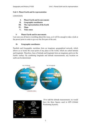
II- Geographic coordinates
Parallels and Geographic meridians form an imaginary geographical network, which
allows us to locate the exact point of any place in the world, which are called latitude
and longitude. Therefore, lines of latitude and longitude form an imaginary grid over the
Earth's surface. By combining longitude and latitude measurements, any location on
earth can be determined.
If we add the altitude measurement, we would
have the three figures used in GPS (Global
Positioning System).
2. Geography and History 1º ESO Unit 1- Planet Earth and its representation
2
The units of measurement for geographic coordinates
are degrees (°), minutes ('), and seconds ("), so:
– Like a circle, the Earth has 360 degrees.
– Each degree is divided into 60 minutes, which in turn
is divided into 60 seconds.
Moreover, latitude and longitude coordinates also
include cardinal directions:
– North or south of the equator for latitude,
– East or west of the prime meridian for longitude.
Parallels are imaginary circles perpendicular to the axis of the earth. They measure 360
degrees.
The Equator is the largest parallel and it divides the earth into two hemispheres: North
and South. We must notice that their number is infinite, although we only draw some of
them. They have E-W direction, and parallels and
meridians cut each other at a right angle. The main
parallels we can find in a world map are:
The meridians are imaginary maximum semicircles
drawn from the North Pole to South Pole. They
measure 180 degrees (half of a circle). The meridian of
reference (0 degrees) is Greenwich, whose name comes
from the astronomical observatory located near London.
Their direction is North- South and they have their
maximum separation in Ecuador and converge at the poles. They cut the parallels at
right angles.
Once we know what parallels and meridians are, we can mark any point on the Earth´s
surface, in other words, the latitude and longitude.
Latitude is the distance expressed in degrees, minutes and seconds, between any point
on the Earth's surface and the parallel 0º or Equator. It is measured northward or
southward. Its value is between 0 and 90 degrees.
On the other hand, longitude is the distance measured in degrees, minutes and seconds,
from any point on the Earth's surface and the meridian 0 (Greenwich). It is measured
east or west. Its value is between 0 and 180 degrees.
III- The representation of the Earth
Since the ancient past, people have used maps to represent the world. Have you ever
drawn the whole Earth? What problems did you have to draw it? The main problem is
trying to draw a three dimension object on a flat sheet of paper. Maybe the solution is to
3. Geography and History 1º ESO Unit 1- Planet Earth and its representation
3
carry a globe inside our backpack before starting our trips...
Remember that Earth Globes are three-dimensional models
(having width, length and depth) that represent the Earth.
Unlike maps, the representation does not give rise to
deformities, expressing reality with more accuracy.
However, globes have a significant problem that makes
them less useful than maps: their poor mobility. Many
globes have drawings of the meridians and parallels, and an
inclined axis is often inserted to symbolize the inclination of
the Earth with respect to the sun.
I think you agree this is not the best solution, and since we know that the Earth is a
sphere, cartographers have tried to represent the 3D Earth in maps. That is the origin of
maps projections.
A map projection is the method to represent the Earth's surface on a plane. It's a system
which translates the meridians and parallels network from a curved surface as the Earth
globe to a flat surface.
There is no perfect method of projection; in fact, all of them distort reality in one way or
another. The use of one projection or another depends on the type and purpose of each
map. Let´s see some of the most important map projections:
https://www.youtube.com/watch?v=X4wgFSHZXBg
https://www.youtube.com/watch?v=eS-C8CcNa7M
4. Geography and History 1º ESO Unit 1- Planet Earth and its representation
4
In conical or conic projections, the reference spherical surface is projected onto a cone
placed over the globe. The cone is cut lengthwise and unwrapped to form a flat map.
In cylindrical projections, the reference spherical surface is projected onto a cylinder
wrapped around the globe. The cylinder is then cut lengthwise and unwrapped to form a
flat map.
In planar (also known as azimuthal or zenithal) projections, the reference spherical
surface is projected onto a plane
The most popular projection has been the Mercator cylindrical one, made in the 16th
century. Mercator is the guilty of our false perception of our world, because the areas
near the Equator are is almost perfect, but there is a lot of distortion in the poles.
For that reason, and trying to represent more accurately the Earth, another cartographer
named Peters made a new projection.
What differences can you see between
both maps?
Try it before watching this video:
http://verne.elpais.com/verne/2015/04/14/
articulo/1429016086_681676.html
IV- Maps
A map is a true representation of the whole or part of an area on a flat surface, although
until recent times it was only of the world people knew.
5. Geography and History 1º ESO Unit 1- Planet Earth and its representation
5
There are numerous types of maps, but, basically, two are emphasized: topographical
and thematic.
a) Topographical maps
Provide information about the physical elements or landscape, representing mountains,
rivers, lakes etc.
b) Thematic maps
These maps are very different, classified by the function of the issue that they represent:
- Political maps
- Physical maps
- Climate maps
- Demographic maps
- Economics
- Etc
Look carefully to this web:
https://www.nps.gov/webrangers/activities/readingmap/
We must know how to read and understand a map, don´t forget we use them very often.
First of all, we have to know how what the scale is: the ratio between the size of the area
represented on the map and the real size of the area. We can find two types of scale:
- Numeric scale: It is expressed as a fraction. The numerator represents a unit on
the map. The denominator represents its size in the real world.
6. Geography and History 1º ESO Unit 1- Planet Earth and its representation
6
- Graphic scale: It is the way to relate the reality with the map. It is a bar divided
into equal segments (1 cm).
In this text you have a brief summary of the main elements you need to know to
read a map:
V- Time zones
The time zones are each of the 24 spherical sectors which divide the land area.
Each of them results to divide the 360º of the Earth globe between the 24 hours that
invests in giving a complete revolution on its own axis. Each time zone measured 15
degrees (360º / 24 hours = 15º, 15º = 1 hour).
The prime meridian or Greenwich meridian is the starting point for the times zones
around the world (GMT). Remember you have to add 1 hour for every time zone you
cross when travelling to the East, and subtract if you travel west.