Master Plan & Delhi Master Plan
•Als PPTX, PDF herunterladen•
43 gefällt mir•20,430 views

Master Plan and Delhi Master Plan Case Study

Empfohlen
Weitere ähnliche Inhalte
Was ist angesagt?
Was ist angesagt? (20)
Ähnlich wie Master Plan & Delhi Master Plan
Ähnlich wie Master Plan & Delhi Master Plan (20)
Mehr von Sahil Kaundal
Kürzlich hochgeladen
Kürzlich hochgeladen (20)
Master Plan & Delhi Master Plan
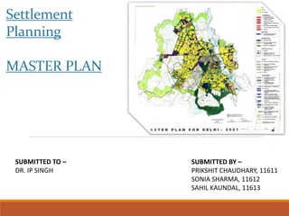
- 1. Settlement Planning MASTER PLAN SUBMITTED BY – PRIKSHIT CHAUDHARY, 11611 SONIA SHARMA, 11612 SAHIL KAUNDAL, 11613 SUBMITTED TO – DR. IP SINGH
- 2. Period of industrial revolution : 1760-1820 • Important epoch in the history of growth of cities. • Between the world wars and especially after world war two – 1939-45. • Many towns and cities have grown up without proper planning. • Overgrown cities became a mess. • Industries were set up in the heart of the cities. • No consideration for transport and utility services HISTORY NEED OF MASTER PLAN
- 3. • Migration of rural population caused housing shortage and increased congestion. • Growing needs of automobiles : development of transport was inadequate – over crowding again. • Industries have encroached upon residential areas :shortage of open spaces and recreational areas. • To eradicate the evils of the ill planned cities, for general welfare of citizens in respect of health, convenience and comfort : need for a comprehensive master plan. NEED OF MASTER PLAN
- 4. HISTORY
- 5. • The Master Plan is a statutory document envisaged for and systematic development of urban areas for horizon year. • It is essentially a land use and network with regulations to control the intensity of use with provision for mid-term appraisal/review. The master plan is both process and product oriented. • The proper development and management of urban areas calls for accurate and vital data to be made available on a periodic basis in order to formulate a responsive spatial planning framework MASTER PLAN
- 6. • Any municipality, from small village to sprawling metropolis, can have a master plan. Small communities will hire a private planning firm to prepare a plan and submit it to the local government for approval. In big cities, the department of city planning prepares the master plan. • The plan itself is a document, sometimes hundreds of pages long, that shows a community as it is and recommends how it should exist in the future. It often contains diagrams, aerial photos, maps , reports and statistical information that support the planner's vision MASTER PLAN
- 7. FEATURES OF MASTER PLAN • Population : the prospective population to be provided for next 30-50 years based on the present population and its growth rate during last 3-4 decades. • Density : standards vary for town center, suburb, type of building, etc. Avg. overall density of 80-100 persons/acre is allowed • Requirement of land : how many acres for over spill to rehabilitate and how many acre for future growth.
- 8. • To guide development of a city in an orderly manner so as to improve the quality of life of its citizens. • Organize and coordinate the complex relationships between urban land uses. • Chart a course for growth and change, be responsive to change and maintain its validity over time and space, and be subject to review. • Direct physical development of the city in relation to its social and economic characteristics based on comprehensive surveys and studies on the present status and the future growth prospects; and Provide a resource mobilization plan for the proposed development. • The implementation of the master plan thus facilitates the orderly and planned development of cities in a sustainable manner and ultimately help in achieving good governance. THE FUNCTIONS OF THE MASTER PLAN :
- 9. • Physical characteristics and natural resources, • City influence area & Settlement System • Demography • Economic base including employment in formal and informal sectors • Housing and shelter • Social infrastructures (health & education) • Transport network (road, railway, water ways and airways) • Utilities & services ( water supply, drainage and sewerage, solid waste management and energy) • Land use • Resource mobilization and Investment Plans. THE MAJOR CONTENTS OF THE MASTER PLAN
- 10. TERMINOLOGY • Master Plan A Master Plan is a long-term plan prepared with the purpose of planned development of cities. The document includes the space requirements for various uses and allocates land for the same. It also spells out the policies, guidelines as per the vision, goal and objectives of the plan. The plan is based on comprehensive surveys and studies on the present status and the future growth prospects which direct the physical development of the city. • Zonal Plan The Zonal Plans detail out the policies of the Master Plan and pertain to a zone as identified by the Master Plan. The development schemes and layout plans indicating various use premises conform to the Zonal Plans. The formulation of the Zonal Plan is stipulated to be within one year as is the case regarding Master Plan of Delhi. In the absence of a Zonal Plan of any area, the development is in accordance with the provisions of the Master Plan.
- 11. • Structure Plan The Structure Plan is the planning framework for an area and includes the distribution of the population, activities, the relationship between land use patterns and development activities and the network and systems of communication, utilities and services respectively. • Perspective Plan Perspective plan is a long term plan (20-25 years) that provides goals, policies, strategies and general programmes of the urban local authority. The plan covers long term policies regarding spatial, economic development, development of infrastructure and resource mobilization and a policy framework to the short term plans.
- 12. • Development Plan A development plan is a medium term plan (generally 5 years) prepared within the framework of the approved perspective plan, providing to the people the comprehensive proposals for socio-economic and spatial development of the urban settlement indicating the manner in which the use of the land and development therein shall be carried out by the local authority and other agencies. • Annual Plan An annual plan conceived within the framework of development plan, is a plan containing the details of new and ongoing projects that the local authority intends to implement during the respective financial year and for which necessary fiscal resources shall be mobilized through plan funds and other sources.
- 13. • Comprehensive Development Plan The development plans are worked on a reduced time span as compared to the master plans, which to some extent has increased the effectiveness of the plans. Comprehensive Development Plan (CDP) is one such effort anchored on the Jawaharlal Nehru National Urban Renewal Mission, which aims at creating economically productive, efficient, equitable and responsive cities. A CDP is both a perspective as well as a vision document for future development of city.
- 14. LAND DISTRIBUTION land is distributed for various uses such as : 1. Residential 2. Commercial 3. Industrial 4. Public and semi public 5. Open spaces 6. Communication 7. Other special uses
- 15. GENERAL LAND USE PATTERN : • Residential : 50-55 % • Commercial : 2-5% • Industrial use : 10-12% • Public and semi public – 8-10 % • Open spaces • parks – 10-15 % • playgrounds • Communication – 15-18% • Other special uses – about 5 %
- 16. • Road widening • re-aligning • Creating open spaces • Parks • Playgrounds • Community facilities PROPOSALS :
- 17. FORMULATION OF A MASTER PLAN • Existing conditions and development issues; • Projected requirements and assessment of deficiencies; • Development aims and objectives • Development proposals • Resource mobilization proposals; • Implementation • Monitoring and review. The detailed Methodology for formulation of Master plans for urban settlements has been spelt out in the Urban Development Plans Formulation and Implementation (UDPFI) Guidelines, 1996. The broad contents are:
- 18. Map of Settlement and environs Base map Direction of Growth Broad Quantum of land required for horizon year Survey Results and Projections DevelopmentStrategy and hierarchy of development Proposed land use Existing Land use Detailed Quantum of land required for horizon year Building Byelaws, if applicable Review Development Control Phasing Funding MechanismProject Prioritization and Cost Monitoring and implementation Zonal Development Plans FORMULATION OF MASTER PLANS
- 19. The most crucial pre-requisite for preparing a Plan is an accurate and updated Base Map of the planning area consisting of physical features • topography • drainage pattern • water bodies • road network • Rail • forest area • settlement areas • spatial extent of development. THE BASE MAP
- 20. PLANNING LEVELS & DATA REQUIREMENT Sl.No Level Scale Source of data 1 Regional Plan 1:50,000 Satellite Images 2 Sub-Regional Plan 1:25,000 Satellite Images 3 Development Plan /Master Plan 1:10,000 High Resolution Satellite Data such as Cartosat -2 4 Zonal Plan 1:2,000 Aerial Photography 5 Site Plan (Planned areas) 1:1,000 Total Station 6 Site Plan (dense built up areas, 1:500 unplanned areas, slums, unauthorized colonies) Total Station
- 21. STEP BY STEP GUIDE FOR FORMULATING MASTER PLANS- AT A GLANCE 1 2 3 4 5 6 S.N O Task Scale Input Agency Outp ut responsible 1 Preparation of Map showing Settlement and enviorns 1:25000/ 1:50000 Cartosat/I konos/QB State Remote Map/ Drg of Settlement and Sensing enviorns showing Agency/ settlements, linkages, outsourcing resources, water bodies etc. 2 Preparation of Base map Correlating Cadastral information 1:10000 -do- -do- Map/Drg of Settlement showing built up areas, existing network,natural features, heritage areas etc 3. Socio –Economic Survey Questioner /Proforma design ULB/Agency Collection & processing of Responsible/ Ward/ House of House hold Consultant data and Projections 4 Preparation of existing Landuse map 1:10000 Cartosat/I konos/QB Detailed Detailed existing landuse by existing land types ie Residential, use survey commercial, industry, etc
- 22. 1 2 3 4 5 6 S.N Task O Scale Input Agency responsible Output 5. Identification of direction of growth 1:1000 0 -do- Department/A uthority/ Organisation etc/ Consultant Delineation of Growth Prospects by analysis of images over various time periods 6 Identification of broad Quantum of land required for horizon year 1:1000 0 Existing density pattern and norms for proposed density Department/A uthority/ Organisation etc/ Consultant Delineation of Areas for Development 7. Identification of detailed Quantum of land required for horizon year 1:10000 and 1:2000/ total station Density prescription as per norms/ buildable areas depending on slopes and soil types/ areas for re- development depending on land ownership, land value, age , condition and height of structures Department/A uthority/ Organisationet c/ Consultant Delineation of Specific pockets for Development
- 23. 2 1 3 4 5 6 S.NO Task Scale Input Agency responsible Output 8 Analysis of Survey results and projections Sample surveys/ secondary Department/Authority/ Specific requirements data/ related studies Organisation etc/ of land for various uses Consultant 9 Spelling out hierarchy of development 1:10,000 Norms and standards Department/Authority/ Identification of Organisation etc/ planning divisions/ Consultant planning zones 10 Proposed land use 1:10,000 GIS applications Department/Authority/ Map/drg showing Organisation etc/ proposed landuse/ Consultant network for the horizon year 11 Development Control Proposed landuse Department/Authority/ Organisation etc/ Consultant Regulating building bulk by activity/premises consisting of uses allowed, not allowed and those allowed with conditions 12 Building Byelaws, if applicable Development Control/NBC, 2005/Model BBl,2004/ Best Practices Department/Authority/ Organisation etc/ Consultant Regulating building construction on premises
- 24. 2 1 3 4 5 6 13 Phasing of Development 1:10,000 Proposed landuse Department/Author ity/ Organisation etc/ Consultant Phase wise development program proposed 14 Priortisation of projects and costing 1:10,000/ 1:2000 Proposed landuse Department/Author ity/ Organisation etc/ Consultant Development priorities 15 Funding possibilities Development Department/Author priorities ity/ Organisation etc/ Consultant Requirement of funds for Master plan implementation 16 Monitoring and implementati on Development Client Agency priorities Review mechanism in place 17 Review Stakeholders State Govt Inequities are addressed 18 Zonal Development Plans 1:2000 Existing land use Department/Author surveys ity/ Organisation etc/ Consultant Detailed development plans for implementation
- 25. DELAY IN PLAN FORMULATION :- Master Plans is a lengthy and time consuming process. The entire process of plan preparation and its approval by State Govts, takes between three to five years in general, and often more • Non-availability of latest base maps resulted in great difficulties in field data collection. • Lack of adequate system of maintaining a data base hampered the informed decision making by the local authorities. • Manual graphic presentations were difficult and thus were limited where as production of maps and visual data can be more easily understood and comprehended by common people. • No efficient system of data storage and retrieval, the monitoring of the master plan was extremely difficult. • Data sharing and coordination among the line departments is very poor
- 26. INTRODUCING DELHI MASTER PLAN 2021
- 28. Objectives of Master Plan •The main objective of master plan is to give direction to future growth of the development area and making viable and practicable adjustment in the already developed unplanned land. •Assessment of proposals of previous master plan, achievements and validity in today’s context. •Formulation of proper goals and objectives for city’s organized development. •Traffic and transportation: effective transportation system to be achieved. •To provide the citizens with basic amenities/ services and it’s balanced distribution. •Interrelationship between various land uses of the city. •Historical buildings, places of architectural importance, conservation and formulation of policies. •To provide the city with a healthy physical environment.
- 29. Development of master plan 2021 Delhi Master plan-2021 was drafted in end 2005. The Delhi Master Plan 2021 was finally notified on February 7, 2007, six years after it was due. The Plan acknowledges 7,000 objections/suggestions. Board of Enquiry, which met 17 times.
- 30. VISION-2021 Vision 2021 is to make Delhi a global metropolis and a WORLD CLASS city. What the term “world class” means is undefined except somewhat commitment “where all the people would be engaged in productive work with a better quality of life, living in a sustainable environment”. Though, this statement should logically apply to all settlements and societies, whether “world class” or not.
- 31. VISION-2021 The population of Delhi in 2001 was 138 lakh as against the MPD-2001 projection of 128 lakh. MPD 2021 comments that “this has had its inevitable implications and impact in terms of shelter, including squatter settlements and other infrastructure facilities”. But does not clarify how a mere 8 percent increase in population have caused the entire city to come tumbling down to such an extent. A serious attempt should be made to get a plan in place that will make Delhi a LIVEABLE city, even if not a world class city.
- 32. POPULATION As per 2001 Census, NCT of Delhi had a total population of 138 lakh. NCT Delhi is highly urbanized with 93.18% of its population living in urban areas as against the national average of 27.81%. During the course of implementation of the plan, attempt should be made to restrict the population of Delhi lower than 220 lakhs. This depends on the effective implementation of policies and proposals of Regional Plan 2021 by Govt. of NCT Delhi. Population Assignment-2021 0 100 200 300 400 500 600 700 NCR NCTD Area Population(inLakh) Populatin (In Lakh) POPULATION ESTIMATE AT FIVE YEAR INTERVAL 138 162 182 199 230 0 50 100 150 200 250 2001 2006 2011 2016 2021 YEARPopulationin(Lakhs) Series2
- 33. HOUSING Housing need is for 24 lakh new houses till 2021 for population of 23 Million. For 24 lakh houses, we need proportionate no. of shops. Provide them at the time we plan for the residential complex. This concept should be built at the planning stage so that shops and other commercial establishments can come up along with houses.
- 34. HOUSING There is considerable dependence between Delhi and the NCR. Some population living in NCR would be coming to Delhi to work and vice-versa. One can certainly assume that the NCR can cater to 20% of the future population demands. 40% can be dealt through re-densification of existing areas and other 40 % through new addition. What is estimated is that 450-500 hectares of land would have to be acquired per annum for next 20 yrs., because of new developments. Still there is a question regarding the feasibility of this suggestion. HOUSING NEED 20% 40% 40% NCR redevelopment/ upgradation of existing reas New Housing
- 35. HOUSING ◦ There is a very feeble act in the master plan: The master plan suggests the following densities for various categories. ◦ Slum housing (up to 30 sq.m)-600 DUs/Ha ◦ Category I (above30-upto40sq.m.)-500 DUs/ Ha ◦ Category II (above40-upto80sq.m.)-250 DUs/ Ha ◦ Category III (above80sqm) - 175 DUs/Ha ◦ The Master plan has varying density like 30sqm i.e. 600 dwelling units per Hectare its impossible to achieve that. Housing Density 0 100 200 300 400 500 600 700 Slum Category-I Category-II Category-III Category DwellingUnitsperHaectare Series1
- 36. UNAUTHORISED COLONIES The demand for the unauthorized colonies “which are to be regularized, should be effectively incorporated in the mainstream of urban development”. This means the payment of heavy penalties and development charges by the offending parties, without any fine being levied on government agencies that were supposed to have provided “authorized” housing in the first place. Unauthorized colonies came up as there was a gap between DEMAND and SUPPLY.
- 37. LANDUSE MPD-2021 advocates the mixed land use concept, to meet the growing demand of commercial activities and overcome the shortfall of available commercial space”. But there is no explanation of why there was a shortfall in the first place? Mixed land use concept of MPD 2021 is a welcome step. LANDUSE DISTRIBUTION 0 10 20 30 40 50 60 ResidentialCom m ercial Industrial G reen/recreational Public Sem ipublic Circulation Land Use %ofland % of Land- MPD-2021 Zonewise Estimated Holding Capacity of Existing Urban Area 0 500 1000 1500 2000 2500 3000 A B C D E F G HD w arkaR ohiniIII R ohiniIV & V N arela Zones Populationin'000' Holding Capacity 2001 Existing population Holding Capacity 2021
- 38. MIXED LANDUSE PROBLEMS ◦ The constant presence of outsiders/shoppers with no local loyalty will erode residential quality and endanger the women, the children and the aged ◦ The water supply & power situations would be worsen. ◦ Vehicular movement with increased parking & goods supply would create chaos with housing areas SOLUTIONS ◦ Segregating entry points into housing and shopping areas as an exclusive public domain for residential use which alone provide safety. ◦ Parking of housing should be separated and commercial parking should be severely restricted. This would not only reduce vehicular nuisance , noise and dust pollution but would also indirectly control the size of commercial activity. ◦ Water, Electricity sewerage and solid waste disposal etc would require increased municipal inputs.
- 39. MIXED LANDUSE Mixed land use has the following advantages. ◦ adds vitality to the city, ◦ cuts down commuting distance, ◦ saves time, energy and investments in transport infrastructure to ◦ provide the citizens a more integrated daily life cycle. ◦ helps improve the quality of life in the city ◦ urban poor, ◦ the aged ◦ the children and ◦ the physically challenged. Ironically, India's urban heritage also was built upon mixed use
- 40. WATER The MPD 2021 Plan mentions that, in the past, “the infrastructure provisions especially those related to water have not matched the pace of development”. But what does it plan for the future? There is, firstly, a dispute between DDA and the Delhi Jal Board (DJB) about how much water is required by an individual in Delhi. The former stipulates 80 gallons per day, while the latter has scaled it down to 60 gallons. DDA projects 1,840 million gallons per day (MGD) while DJB computes 1,380 mgd. Against this, the current treatment capacity in Delhi is just 805 mgd. where will all the water come from? Water Demand in (MGD) 0 200 400 600 800 1000 1200 1400 1600 2007 2011 2021 Year WaterDemandin(MGD) Water Demand in (MGD)
- 41. SANITATION Delhi's sanitation in a pathetic state. Most of its sewer lines SILTED and NOT FUNCTIONING, according to a UN report. A large proportion of Delhi's 5,600-km of feeder sewers are silted and less than 15 percent of the trunk sewer line is functioning. The city's 17 sewerage plants are inadequate to process the waste, and most of the plants operate far below capacity.
- 42. SANITATION The end result is that less than half the waste is processed by the sewerage plants before the filth is dumped into the already polluted Yamuna river. Sewarage Augmentation Plan 0 20 40 60 80 100 120 140 160 180 Okhla Coronati onpillar Sen Nursing Timarpur Rohini Vasant Kunj Treatment Plant Capacityin(MGD) Capacity 2001 in (MGD Capacity 2021 in (MGD
- 43. E- WASTE Disposing of ordinary torch cell batteries may not strike you as dangerous. In India, we use nearly 200,000 tonnes of industrial and domestic batteries every year and dump them carelessly. These batteries contain mercury, cadmium and lead - all substances lethal to the human system. Once they permeate into the water table, these cannot be fully removed by any existing water purification system in the country These metals cannot be excreted by the body. They accumulate in our system and affect our mental health.
- 44. TRANSPORTATION There was an urgent need to streamline the basic transport system before CWG-2010. A study points out that commuters are paying 150 percent more than the actual auto fares in the city! Metro Rail network proposal covering a length of 56.76KM is a good news.
- 45. PARKING POLICY There is a proposal of making 175 new parking sites, 18 new multi-level parking facilities. Opening up DTC depots for private parking and revision of parking charges for private transport. It also approved formation of 43 corridors with 575 km route length for Integrated Multi-Modal Transit System for public transport. Public transport must be encouraged.
- 46. TUNNEL ROAD PROJECT A tunnel road project linking NH-24 to Lodhi Road was proposed in draft Master Plan. It will connect “Common wealth village site” and “Jawahar lal Nehru stadium”. The tunnel would pass under Sunder Nersury (near HUMAYUS TOMB) and Neela Gumbad ending near Jawahar Lal Stadium. ASI, after thrice earlier rejecting a tunnel road project finally approved it.
- 47. COMMON WEALTH VILLAGE(NEARAKHSHADHAM TEMPLE) The site for common wealth village wasselected on the river bed near Akhshardham Temple. Rupees 150 crore were earmarked for developing the Commonwealth Village and Rs 400 crore for improvement of infrastructure such as modernization and lengthening of roads.
- 48. NEW STADIUMS Indoor stadiums have been constructed at the J.N. Stadium, I. G. Sports Complex, Siri Fort and Yamuna Complex. The Indian capital will have five new stadiums. These stadiums will come up in the heart of the capital, which will create serious problem of transportation.
- 49. Thanks…