ANGLO-SAXON ARTIFACTS
•Als DOC, PDF herunterladen•
1 gefällt mir•1,013 views

ANGLO-SAXON CEMETERY ARTIFACTS (Sittingbourne, Kent, SE England, c.650 AD) Dr. R.M. de Jonge ©, drsrmdejonge@hotmail.com

Empfohlen
Weitere ähnliche Inhalte
Was ist angesagt?
Was ist angesagt? (20)
Andere mochten auch
Andere mochten auch (14)
Ähnlich wie ANGLO-SAXON ARTIFACTS
Ähnlich wie ANGLO-SAXON ARTIFACTS (7)
Kürzlich hochgeladen
Kürzlich hochgeladen (20)
ANGLO-SAXON ARTIFACTS
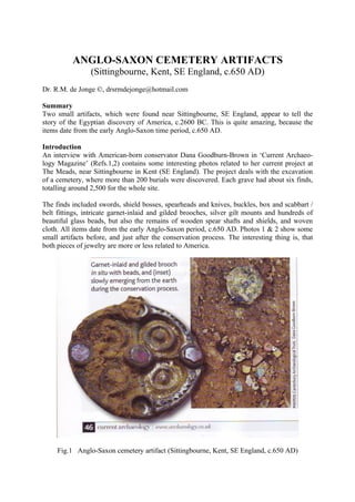
- 1. ANGLO-SAXON CEMETERY ARTIFACTS (Sittingbourne, Kent, SE England, c.650 AD) Dr. R.M. de Jonge ©, drsrmdejonge@hotmail.com Summary Two small artifacts, which were found near Sittingbourne, SE England, appear to tell the story of the Egyptian discovery of America, c.2600 BC. This is quite amazing, because the items date from the early Anglo-Saxon time period, c.650 AD. Introduction An interview with American-born conservator Dana Goodburn-Brown in ‘Current Archaeo- logy Magazine’ (Refs.1,2) contains some interesting photos related to her current project at The Meads, near Sittingbourne in Kent (SE England). The project deals with the excavation of a cemetery, where more than 200 burials were discovered. Each grave had about six finds, totalling around 2,500 for the whole site. The finds included swords, shield bosses, spearheads and knives, buckles, box and scabbart / belt fittings, intricate garnet-inlaid and gilded brooches, silver gilt mounts and hundreds of beautiful glass beads, but also the remains of wooden spear shafts and shields, and woven cloth. All items date from the early Anglo-Saxon period, c.650 AD. Photos 1 & 2 show some small artifacts before, and just after the conservation process. The interesting thing is, that both pieces of jewelry are more or less related to America. Fig.1 Anglo-Saxon cemetery artifact (Sittingbourne, Kent, SE England, c.650 AD)
- 2. (Courtesy L. Westcott, Ref.1) The Brooch The Brooch (Fig.1) has the round shape of the planet Earth. The four concentric circles in the background refer to the Fourth Dynasty of Egypt. The garnet in the center symbolizes the 4+1= 5th king. The 5th king Menkaure (Mycerinos) of the Fourth Dynasty discovered Ame- rica via the southern Aleutian islands at the south side of the Bering Sea, at 51.5°N. It is the latitude of this cemetery near Sittingbourne, just south of the mouth of the River Thames, in SE England. – The holy Arctic Circle is situated at 67°N. It is the northernmost line the Sun still shines at midwinter day. The garnet in the center shows he returned via the Bering Strait, 1° below the Arctic Circle, at 67-1= 66°N. (Latitudes were used as early as c.4700 BC, Refs.3,4). (Turn the Brooch over an angle of 45°.) The 5 garnets of the Brooch symbolize the Fifth Dy- nasty. The 2 lowest garnets refer to the 2nd king. The 2nd king Sahure of the Fifth Dynasty discovered the two Southern Crossings of the North Atlantic Ocean. He sailed from the Cape Verde Islands over 2 Moiras (= 20°), with the wind and the current, to Cape São Roque (the Holy Rock), Brazil, at 5°S. On the Return Route he sailed from Newfoundland over 2 Moiras (= 20°), with the wind and the current, to the two islands of the West Azores, at 39°N. It corresponds with the complementary latitude of this cemetery near Sittingbourne, at the mouth of the River Thames, at 90-39= c.51°N. In antiquity the use of complementary latitu- des was very common. The 3 higher garnets refer to three land points: the Shetland Islands, the south cape of Green- land and Cape Chidley, Canada, located at the complementary latitude of the Nile Delta, at 90 -30= 60°N. Note, that the garnets illustrate the shape of South Greenland. This third, Northern Crossing was discovered by the 3rd king Nefererkare. The mentioned kings were all three descended from the Nile Delta, at 30°N. The 3 lower garnets refer to Abaco Island, Northern Bahama’s, 3° below the Nile Delta, at 30-3= 27°N. The 2 higher garnets refer to Bermuda, 2° above the Nile Delta, at 30+2= 32°N. The 4 concentric circles and the 5 garnets of the Brooch confirm its latitude, 4+5= 9° above the holy Tropic of Cancer, at 23+9= 32°N. (At midsummer day the Sun is there at right angles above.) So, the 9th and last king Unas of the Fifth Dynasty discovered the Return Route from Abaco Island via Bermuda to the nine islands of the Azores. (Refs.3-9)
- 3. Fig.2 Anglo-Saxon cemetery artifact (Sittingbourne, Kent, SE England, c.650 AD) (Courtesy L. Westcott, Ref.1) The Sword Boss The four sides of the square in the background refer to the Fourth Dynasty (Fig.2). The garnet in the center symbolizes the 4+1= 5th king. The 5th king Menkaure (Mycerinos) of the Fourth Dynasty discovered America via the southern Aleutian islands at the south side of the Bering Sea, at 51.5°N. It is the latitude of this cemetery near Sittingbourne in Kent (SE England). – The holy Arctic Circle is situated at 67°N. It is the northernmost line the Sun still shines at midwinter day. The garnet shows he returned via the Bering Strait, 1° below the Arctic Circle, at 67-1= 66°N. (Refs.3,4) The four legs of the X and the garnet of the Sword Boss symbolize the 4+1=5th Dynasty. The 2 lower legs refer to the 2nd king. The 2nd king Sahure of the Fifth Dynasty discovered the two Southern Crossings of the North Atlantic Ocean. He sailed from the Cape Verde Islands over 2 Moiras (= 20°), with the wind and the current, to Cape São Roque (the Holy Rock), Brazil, at 5°S. On the Return Route he sailed from Newfoundland over 2 Moiras (= 20°), with the wind and the current, to the two islands of the West Azores, at 39°N. It corresponds with the complementary latitude of this cemetery near Sittingbourne in Kent, at 90-39= c.51°N. The two higher legs of the X and the garnet refer to 2+1= 3 land points: the Shetland Islands, the south cape of Greenland and Cape Chidley, Canada, located at the complementary latitude of the Nile Delta, at 90-30= 60°N. The V-shape illustrates the coast of South Greenland. This third, Northern Crossing was discovered by the 3rd king Nefererkare. The mentioned kings were all three descended from the Nile Delta, at 30°N. (Note, that the Staffordshire Hoard [see Fig.2] was found at 50+3= 53°N, which is the latitude in honor of this third king of the Fifth Dynasty.) The two lower legs of the X and the garnet refer to Abaco Island, Northern Bahama’s, 2+1= 3° below the Nile Delta, at 30-3= 27°N. The two higher legs refer to Bermuda, 2° above the Nile Delta, at 30+2= 32°N. The 4 sides of the square, the 4 legs of the X, and the garnet of the
- 4. Sword Boss confirm its latitude, 4+4+1= 9° above the holy Tropic of Cancer, at 23+9= 32°N. So, the 9th and last king Unas of the Fifth Dynasty discovered the Return Route from Abaco Island via Bermuda to the nine islands of the Azores. (Refs.5-13) Religion What might be the reason that both artifacts appear to tell the story of the Egyptian discovery of America? The reason is simple. The Egyptian SunGod Ra has said: “The Realm of the Dead is in the west, at the other side of the Waters (the Ocean), in the Land where the Sun sets (America). After death you will reunite there with your family, your friends, your ac- quaintences.” - Note, that both items show the so-called Ennead, a group of nine mysterious, Egyptian gods. The ancient Egyptian “Book of the Dead” is a collection of about 180 funerary texts, which are illustrated with so-called vignettes (Ref.14). The whole book is full of mystery, but it deals with the spiritual journey of the King to the “Underworld”, which is … America. Spell 180 (and those around this number) deal with America in particular, symbolically situated 18 Moiras= 180° west of Egypt, at the back side of the planet Earth. (The circumference equals 36 Moiras= 360°.) Note, that King Menkaure, who discovered America, resigned after 18 years of reign. He is the only king mentioned in the Book of the Dead (Spell 30)! The second paragraph of Spell 180 reads: “O Re, you who go to rest as Osiris with all the ap- pearings in glory of the spirits and gods of the West; you are the hidden one of the Nether- world, the holy soul at the head of the West …” The south point of the Gulf of Campeche, Mexico, at 18°N, became the center of the ancient civilization of the famous Land of Punt. The whole Gulf of Campeche was even adopted as an Egyptian hieroglyph (Figs.3&4) (Ref. 15). Both artifacts date from c.650 AD, which is halfway the first millennium of the Christian Era. The rise of the Christian religion was rather late in England, but still it is amazing, that these pieces of jewelry would deal with a forgotten story from the Old Kingdom of Egypt. How- ever, the Egyptian civilization lasted more than three millennia, which is six times longer in the past. In additon, most people forget that Christianity is a reformulation of the Egyptian re- ligion. Note, that both religions proclaim a King as Head of State. Fig.3 This Egyptian hieroglyph strongly resembles a map of the Gulf of Campeche, Mexico. (Courtesy R.H.Wilkinson, Ref.15)
- 5. Fig.4 This Egyptian hieroglyph strongly resembles a setting Sun in a valley in the west. However, it is based on the previous hieroglyph. So, it deals with the arrival of the SunGod in America. For a long time period, America was a colony of Egypt (Atlantis, c.2500-1200 BC) (Courtesy R.H.Wilkinson, Ref.15) References 1. Westcott, L., Current Archaeology, Issue 245, (Vol.XXI, No.5), Aug. 2010 (ISBN 9-7700- 11-321005) 2. Website: www.archaeology.co.uk 3. De Jonge, R.M., and Wakefield, J.S., How the Sungod Reached America, c.2500 BC, A Guide to Megalithic Sites, MCS Inc., 2002 (ISBN 0-917054-19-9). Available: MCS Inc., Box 3392, Kirkland, Wa 98083, also on CD. Website: www.howthesungod.com 4. Wakefield, J.S., and De Jonge, R.M., Rocks & Rows, Sailing Routes across the Atlantic and the Copper Trade, MCS Inc, 2010 (ISBN 0-917054-20-2). Available: MCS Inc, Box 3392, Kirkland, Wa USA 98033. Website: www.rocksandrows.com 5. De Jonge, R.M., Website: www.slideshare.net/rmdejonge/ 6. De Jonge, R.M., “The Discovery of Three Continents (Santo Stefano, North Sardinia, Italy, c. 2300 BC)”, Ancient American, Vol.12, No.76, pgs.28-29 (2007), Ref.5. 7. De Jonge, R.M., “Houghton’s Petroglyph (Copper Country, Michigan, 2500-1200 BC)”, Ref.5, to be published. 8. De Jonge, R.M., “The Mystic Symbol, mark of the Michigan Mound Builders”, Ref.5, to be published. 9. De Jonge, R.M., “Discovery of America and the Flood (c.2300 BC, Ita Letra, Villarrica, Paraguay)”, Ref.5 to be published. 10. De Jonge, R.M., “The Battersea Shield (River Thames, London, c.190 BC)”, Ref.5, to be published. 11. De Jonge, R.M., “A Sword for America (Kirkburn, East Yorkshire, England, c.250 BC)”, Ref.5, to be published. 12. De Jonge, R.M., The Phaistos Disc Decoded, New Testimony of a Lost Civilization, Mid- western Epigraphic Journal, Vol.20, 111-115 (2006), and Vol.21, 74-80 (2007), to be publish- ed. 13. Rydholm, C.F., Michigan Copper, The Untold Story, Winter Cabin Books, Marquette, 2006 (ISBN 0-9744679-2-8).
- 6. 14. Faulkner, R.O., The Ancient Egyptian Book of the Dead, British Museum Press, London (2010) (ISBN 978-07141-1992-2) 15. Wilkinson, R.H., Reading Egyptian Art, A Hieroglyphic Guide to Ancient Egyptian Pain- ting and Sculpture, Thames & Hudson, London (2011) (ISBN 978-0-500-27751-5)