FOUR CHAMBERS (I), CO
•Als DOC, PDF herunterladen•
1 gefällt mir•698 views

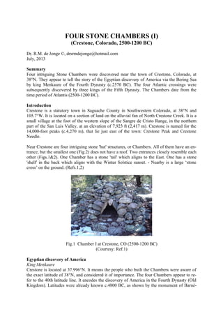
FOUR STONE CHAMBERS (I) (Crestone, Colorado, 2500-1200 BC) Dr. R.M. de Jonge ©, drsrmdejonge@hotmail.com July, 2013 Summary Four intriguing Stone Chambers were discovered near the town of Crestone, Colorado, at 38°N. They appear to tell the story of the Egyptian discovery of America via the Bering Sea by king Menkaure of the Fourth Dynasty (c.2570 BC). The four Atlantic crossings were subsequently discovered by three kings of the Fifth Dynasty. The Chambers date from the time period of Atlantis (2500-1200 BC).

Empfohlen
Weitere ähnliche Inhalte
Was ist angesagt?
Was ist angesagt? (20)
Ähnlich wie FOUR CHAMBERS (I), CO
Mehr von INSTITUTE OF MEGALITHIC RESEARCH
Mehr von INSTITUTE OF MEGALITHIC RESEARCH (6)
Kürzlich hochgeladen
Kürzlich hochgeladen (20)
FOUR CHAMBERS (I), CO
- 1. FOUR STONE CHAMBERS (I) (Crestone, Colorado, 2500-1200 BC) Dr. R.M. de Jonge ©, drsrmdejonge@hotmail.com July, 2013 Summary Four intriguing Stone Chambers were discovered near the town of Crestone, Colorado, at 38°N. They appear to tell the story of the Egyptian discovery of America via the Bering Sea by king Menkaure of the Fourth Dynasty (c.2570 BC). The four Atlantic crossings were subsequently discovered by three kings of the Fifth Dynasty. The Chambers date from the time period of Atlantis (2500-1200 BC). Introduction Crestone is a statutory town in Saguache County in Southwestern Colorado, at 38°N and 105.7°W. It is located on a section of land on the alluvial fan of North Crestone Creek. It is a small village at the foot of the western slope of the Sangre de Cristo Range, in the northern part of the San Luis Valley, at an elevation of 7,923 ft (2,417 m). Crestone is named for the 14,000-foot peaks (c.4,270 m), that lie just east of the town: Crestone Peak and Crestone Needle. Near Crestone are four intriguing stone 'hut' structures, or Chambers. All of them have an en- trance, but the smallest one (Fig.2) does not have a roof. Two entrances closely resemble each other (Figs.1&2). One Chamber has a stone 'tail' which aligns to the East. One has a stone 'shelf' in the back which aligns with the Winter Solstice sunset. - Nearby is a large ‘stone cross’ on the ground. (Refs.1,2) Fig.1 Chamber I at Crestone, CO (2500-1200 BC) (Courtesy: Ref.1) Egyptian discovery of America King Menkaure Crestone is located at 37.996°N. It means the people who built the Chambers were aware of the exact latitude of 38°N, and considered it of importance. The four Chambers appear to re- fer to the 40th latitude line. It encodes the discovery of America in the Fourth Dynasty (Old Kingdom). Latitudes were already known c.4800 BC, as shown by the monument of Barné-
- 2. nez, Brittany, France. Two Chambers have similar entrances, confirming this main latitude line, 2° above the Site, at 38+2= 40°N. Crestone Peak and Crestone Needle, the two peaks just east of the town, confirm it, again. It happened at the southern Aleutian islands, at the south side of the Bering Sea, at the com- plementary latitude of 90-40= c.50°N by the 5th king Menkaure (Mycerinos, c.2580-2562 BC) of this dynasty. In antiquity the use of complementary latitudes was very common. The length of the 40th latitude line from coast to coast across North America equals 50°, confirming it. The latitude line of Crestone crosses the Arkansas River in the east five times, confirming it, again. – The meridian, or north-south line of Crestone leaves the West Coast of Mexico 38- 20= 18° below the Site, confirming his 18 years of reign. The meridian of the Site runs to the South Platte River, 1° higher, at 38+1= 39°N. The exact level of the southern Aleutian islands is provided by its complementary latitude, at 90-39= 51°N. The holy Arctic Circle, at 67°N, is the northernmost line the Sun still shines at midwinter day (Sun religion). It shows king Menkaure returned via the Bering Strait, 1° below it, at 67-1= 66°N. He discovered this crossing, too, 66-51= 15° above the southern Aleutian islands. Two Chambers have similar entrances, which confirms he discovered two crossings. Crestone Peak and Crestone Needle, the two peaks just east of the town, confirm it, again. (Refs.3-6) Fig.2 Chamber II at Crestone, CO (2500-1200 BC) (Courtesy: Ref.1) Crossings of the Atlantic King Sahure The southern Cape Verde islands, off shore West Africa, are situated at 15°N (see above). The Nile Delta, at 30°N, encodes the sailing direction of the Southern Crossing of the Atlantic, with the wind and the current, 30° SSW. The 50th latitude line near the southern Aleutians en- codes the point of arrival, Cape São Rock (the Holy Rock), Brazil, at 5°S, as well as the Fifth Dynasty. The sailing distance of 2 Moiras, or 20°, encodes the 2nd king Sahure (c.2510-2498 BC), who discovered it. Two Chambers have similar entrances, which confirm this discovery by the 2nd king. – Crestone is located 50-38= 12° below the 50th latitude line, confirming his 12 years of reign.
- 3. This King had to return. Crestone is located at the level of the nine islands of the Azores in the middle of the Ocean, at 38°N. It shows he returned from Cape Race, the SE Cape of New- foundland, 9° above Crestone, at 38+9= 47°N. The initial sailing direction, with the wind and the current, is 20° ESE, and the sailing distance is 2 Moiras, or 20°, to the two islands of the West Azores. The two peaks, Crestone Peak and Crestone Needle, illustrate this Crossing was discovered by this 2nd king, as well. The West Azores are located at 39°N, as indicated by the meridian of the site, which runs to the South Platte River at this latitude. It also runs to the North Platte River, 43-38= 5° above the Site, which confirms it happened in the Fifth Dynasty. The five islands of the Central Azores at the latitude of Crestone confirm it. The two Upright Stones of both entrances of Chambers I and II (Figs.1&2) confirm the two southern crossings of the Ocean were discove- red by the 2nd king Sahure of this dynasty. The two Upright Stones of both entrances refer to the Strait of Gibraltar, 2° below Crestone, at 38-2= 36°N. It is the exit of the Mediterranean Sea. The four Chambers are located at the level of the 9 islands of the Azores, confirming this latitude at 4x9= 36°N. It refers to the cir- cumference of the planet Earth of 36 Moiras, or 360° (1 Egyptian Moira= 10 moiras= 10°). It shows the 2nd king Sahure was the first king who circumnavigated the Earth. Crestone is located at 38°N. The village is named for the two 14,000-foot peaks (c.4,270 m), that lie just east of the town: Crestone Peak and Crestone Needle. These have a height of 4,270/111= c.38 millimoiras (1 moira= 1°= 111 km). They confirm this particular latitude. The complementary latitude of 90-38= 50+2= 52°N confirms the 2nd king Sahure of the Fifth Dynasty, who discovered the two southern crossings of the Ocean. (Refs.7-11) Fig.3 Chamber III at Crestone, CO (2500-1200 BC) (Courtesy: Ref.1) King Neferirkare The Nile Delta is located at 30°N. It encodes the Northern Crossing of the Ocean from the Shetland Islands, via the South Cape of Greenland, to Cape Chidley, Canada, at the comple- mentary latitude of 90-30= 60°N. It was discovered by the 3rd king Neferirkare (c.2498-2478 BC). So, the third crossing of the Ocean was discovered by this 3rd king, as illustrated by the three Chambers with roofs at Crestone. Two Chambers have similar entrances with a third
- 4. Stone at the top (Figs.1&2), confirming it, twice. – The meridian of Crestone leaves the West Coast of Mexico at 20°N, confirming the 20 years of reign of this King. King Unas The last discovered crossing starts at Abaco Island, northern Bahama’s, 3° below the Missis- sippi Delta, at 30-3= 27°N. The 2nd king Sahure (c.2510-2498 BC) reigned for 12 years. It shows the sailing distance to Bermuda, at 30+2= 32°N, was 12 moiras, or 12°. This island is located 9° above the holy Tropic of Cancer, at 23+9= 32°N. At midsummer day the Sun is there at right angles above (Sun religion). It shows the Crossing from Bermuda to the nine islands of the Azores was discovered by the 9th and last king Unas (c.2403-2370 BC) of this dynasty. Chamber II has a fourth, Cover Sto- ne above the entrance (Fig.2), confirming this fourth Egyptian King. Crestone is located at the latitude of the three island groups of the Azores (the East, Central, and West Azores), which encode the long sailing distance, with the wind and the current, of 3 Moiras, or 30°. The three Chambers with roofs confirm it. The 2nd king Sahure of the Fifth Dynasty sailed from the five islands of the Central Azores to the two islands of Madeira, at 38-5= 33°N. Their latitude encodes the 33 years of reign of king Unas (c.2403-2370 BC). He discovered the island of Bermuda, 50-32= 18° below the 50th latitude line, confirming the 18 years of reign of king Menkaure (c.2580-2562 BC), who discovered America. - The four Chambers of Crestone were made in honor of the four Egyp- tian Kings who were involved in the discovery of America. However, they also celebrate the four discovered crossings of the Atlantic Ocean. (Refs.12-17) Fig.4 Chamber IV at Crestone, CO (2500-1200 BC) (Courtesy: Ref.1) Religion The 18 years of reign of king Menkaure refer to the ancient civilization around the south point of the Gulf of Campeche, Mexico, at 18°N. It was the place where the Olmec civilization star- ted, the holiest place of the America’s. It is the center of the Underworld, “the Realm of the Dead, at the other side of the waters (the Ocean), in the land where the Sun sets (America).”
- 5. It is located at half the latitude of the Strait of Gibraltar, at 36/2= 18°N. It is the center of the Land of Punt, at a symbolic distance of half the circumference of the planet Earth, 18 Moiras, or 180° from the Land of the Living (Egypt). The ancient Egyptian “Book of the Dead” con- tains c.180 Spells for the Afterlife, confirming it. It is the oldest book on Earth. (Refs.18-32) Fig.5 The 5th king Menkaure (c.2580-2562 BC) of the Fourth Dynasty, who discovered America via the Bering Sea. (Boston Museum of Fine Arts) Date North and South America were colonies of Egypt between c.2500 and 1200 BC. Together, they formed the empire of Atlantis. It was the time period of the metal trade from America to the Old World. Copper from Upper Michigan and Isle Royale, and tin, silver and gold from Bolivia were shipped across the Ocean to the Mediterranean. The four stone Chambers of Crestone, CO, date from this time period. Monuments celebrating the Egyptian discovery of America were not made anymore after the fall of the Empire of Atlantis, c.1200 BC. References 1. Native American Research and Preservation, Inc., Website: http://stonequest.org/StoneHuts.aspx 2. Molina, Y., FB Group: “Mystery Mountain, West Virginia” 3. De Jonge, R.M., and Wakefield, J.S., How the SunGod Reached America c.2500 BC, A Guide to Megalithic Sites, 2002 (ISBN 0-917054-19-9). Available: MCS Inc., Box 3392, Kirkland, Wa 98083, also on CD. Website: www.howthesungod.com 4. Wakefield, J.S., and De Jonge, R.M., Rocks & Rows, Sailing Routes across the Atlantic and the Copper Trade, MCS Inc, 2010 (ISBN 0-917054-20-2). Available: MCS Inc, Box 3392, Kirkland, Wa USA 98083. Website: www.rocksandrows.com 5. De Jonge, R.M., Website: www.slideshare.net/rmdejonge 6. Pellech, Chr., Website: www.migration-diffusion.info 7. De Jonge, R.M., “The Discovery of Three Continents (Santo Stefano, North Sardinia, Italy, c.2300 BC)”, An- cient American, Vol.12, No.76, pgs.28-29 (2007), Ref.5.
- 6. 8. De Jonge, R.M., “Houghton’s Petroglyph (Copper Country, Michigan, 2500-1200 BC)” (2009), Ref.5, to be published. 9. De Jonge, R.M., “The Mystic Symbol, mark of the Michigan Mound Builders” (2009), Ref.5, to be publish- ed. 10. De Jonge, R.M., “A Sword for America (Kirkburn, East Yorkshire, England, c.250 BC)” (2009), Ref.5, to be published. 11. De Jonge, R.M., “The Battersea Shield (River Thames, London, c.190 BC)” (2009), Ref.5, to be published. 12. De Jonge, R.M., and Wakefield, J.S., “Discovery of the Islands in the Ocean (Cairn T, Loughcrew, Co. Meath, Ireland, c.3200 BC)” (2011), Ref.5, to be published. 13. De Jonge, R.M., and Wakefield, J.S., "The Passage Grave of Karleby, Encoding the Islands Discovered in the Ocean, c.2950 BC", Migration & Diffusion, Vol.5, No.18, pgs.64-74 (2004), Ref.6. 14. De Jonge, R.M., and Wakefield, J.S., "The Three Rivers Petroglyph, A Guide-post for River Travel in Ame- rica", Migration & Diffusion, Vol.3, No.12, pgs.74-100 (2002), Ref.6. 15. De Jonge, R.M., and Wakefield, J.S., “A Nautical Center for Crossing the Ocean, America’s Stonehenge, New Hampshire, c.2200 BC”, Migration & Diffusion, Vol.4, No.15, pgs.60-100 (2003), Ref.6. 16. De Jonge, R.M., “Stonehenge, Monument for the Discovery of America (Salisbury Plain, South England, c.2000 BC)” (2011), Refs.5,6, to be published. 17. De Jonge, R.M., “Tripod Rock, Pyramid Mountain (Morris County, New Jersey, c.1900 BC)” (2011), Refs.- 5,6, to be published. 18. De Jonge, R.M., “The Comet Catastrophe of c.2345 BC”, (sixteen articles), Webpage: http://www.barry.warmkessel.com/dejonge.html 19. De Jonge, R.M., “Gold Ring (Grand Canyon, Arizona, c.1450 BC)” (2010), Ref.5, to be published. 20. De Jonge, R.M., “Sentinel Rock, Vermont (Discovery of America and Biblical Flood, c.1900 BC)” (2011), Refs.5,6, to be published. 21. De Jonge, R.M., “Oil City Glyphs (Pennsylvania, c. 2000 BC)” (2012), Ref.5, to be published. 22. Rydholm, C.F., Michigan Copper, The Untold Story, Winter Cabin Books, Marquette, 2006 (ISBN 0- 9744679-2-8). 23. De Jonge, R.M., “Megaliths of Arrowhead Region I (Minnesota, c.1900 BC)” (2012), Ref.5, to be published. 24. De Jonge, R.M., “Megaliths of Arrowhead Region II (Minnesota, c.1900 and c.770 BC BC)” (2012), Ref.5, to be published. 25. De Jonge, R.M., “Grave Creek Mound (I) (Moundville, Marshall County, WV)” (2012), Ref.5, to be pu- blished. 26. De Jonge, R.M., “Grave Creek Mound (II) (c.720 BC, Moundville, Marshall County, WV)” (2012), Ref.5, to be published. 27. De Jonge, R.M., “Copper Spear Tip, (Crow Wing County, MN, c.1500 BC)”, (2013), Ref.5. 28. De Jonge, R.M., “Ancient Stone Balls, (Redwood Co. and Stevens Co., MN, c.1900 BC)”, (2013), Ref.5. 29. De Jonge, R.M., “Circle Cross Symbol, (Copper Harbor, Upper Michigan, c.1900 BC)”, (2013), Ref.5. 30. Faulkner, R.O., The Ancient Egyptian Book of the Dead, British Museum Press (2010) (ISBN 978-0-7141- 1992-2). 31. Robin Mueller, FB Group: “Old Copper Complex and Ancient Waterways America”. 32. Susan English, Yahoo Group of the Ancient Waterways Society.
- 7. 8. De Jonge, R.M., “Houghton’s Petroglyph (Copper Country, Michigan, 2500-1200 BC)” (2009), Ref.5, to be published. 9. De Jonge, R.M., “The Mystic Symbol, mark of the Michigan Mound Builders” (2009), Ref.5, to be publish- ed. 10. De Jonge, R.M., “A Sword for America (Kirkburn, East Yorkshire, England, c.250 BC)” (2009), Ref.5, to be published. 11. De Jonge, R.M., “The Battersea Shield (River Thames, London, c.190 BC)” (2009), Ref.5, to be published. 12. De Jonge, R.M., and Wakefield, J.S., “Discovery of the Islands in the Ocean (Cairn T, Loughcrew, Co. Meath, Ireland, c.3200 BC)” (2011), Ref.5, to be published. 13. De Jonge, R.M., and Wakefield, J.S., "The Passage Grave of Karleby, Encoding the Islands Discovered in the Ocean, c.2950 BC", Migration & Diffusion, Vol.5, No.18, pgs.64-74 (2004), Ref.6. 14. De Jonge, R.M., and Wakefield, J.S., "The Three Rivers Petroglyph, A Guide-post for River Travel in Ame- rica", Migration & Diffusion, Vol.3, No.12, pgs.74-100 (2002), Ref.6. 15. De Jonge, R.M., and Wakefield, J.S., “A Nautical Center for Crossing the Ocean, America’s Stonehenge, New Hampshire, c.2200 BC”, Migration & Diffusion, Vol.4, No.15, pgs.60-100 (2003), Ref.6. 16. De Jonge, R.M., “Stonehenge, Monument for the Discovery of America (Salisbury Plain, South England, c.2000 BC)” (2011), Refs.5,6, to be published. 17. De Jonge, R.M., “Tripod Rock, Pyramid Mountain (Morris County, New Jersey, c.1900 BC)” (2011), Refs.- 5,6, to be published. 18. De Jonge, R.M., “The Comet Catastrophe of c.2345 BC”, (sixteen articles), Webpage: http://www.barry.warmkessel.com/dejonge.html 19. De Jonge, R.M., “Gold Ring (Grand Canyon, Arizona, c.1450 BC)” (2010), Ref.5, to be published. 20. De Jonge, R.M., “Sentinel Rock, Vermont (Discovery of America and Biblical Flood, c.1900 BC)” (2011), Refs.5,6, to be published. 21. De Jonge, R.M., “Oil City Glyphs (Pennsylvania, c. 2000 BC)” (2012), Ref.5, to be published. 22. Rydholm, C.F., Michigan Copper, The Untold Story, Winter Cabin Books, Marquette, 2006 (ISBN 0- 9744679-2-8). 23. De Jonge, R.M., “Megaliths of Arrowhead Region I (Minnesota, c.1900 BC)” (2012), Ref.5, to be published. 24. De Jonge, R.M., “Megaliths of Arrowhead Region II (Minnesota, c.1900 and c.770 BC BC)” (2012), Ref.5, to be published. 25. De Jonge, R.M., “Grave Creek Mound (I) (Moundville, Marshall County, WV)” (2012), Ref.5, to be pu- blished. 26. De Jonge, R.M., “Grave Creek Mound (II) (c.720 BC, Moundville, Marshall County, WV)” (2012), Ref.5, to be published. 27. De Jonge, R.M., “Copper Spear Tip, (Crow Wing County, MN, c.1500 BC)”, (2013), Ref.5. 28. De Jonge, R.M., “Ancient Stone Balls, (Redwood Co. and Stevens Co., MN, c.1900 BC)”, (2013), Ref.5. 29. De Jonge, R.M., “Circle Cross Symbol, (Copper Harbor, Upper Michigan, c.1900 BC)”, (2013), Ref.5. 30. Faulkner, R.O., The Ancient Egyptian Book of the Dead, British Museum Press (2010) (ISBN 978-0-7141- 1992-2). 31. Robin Mueller, FB Group: “Old Copper Complex and Ancient Waterways America”. 32. Susan English, Yahoo Group of the Ancient Waterways Society.