Geo summative 1960 valdivia earthquake
•Als PPTX, PDF herunterladen•
4 gefällt mir•5,198 views


Empfohlen
Weitere ähnliche Inhalte
Was ist angesagt?
Was ist angesagt? (20)
Andere mochten auch
Andere mochten auch (20)
Ähnlich wie Geo summative 1960 valdivia earthquake
Ähnlich wie Geo summative 1960 valdivia earthquake (20)
Kürzlich hochgeladen
Kürzlich hochgeladen (20)
Geo summative 1960 valdivia earthquake
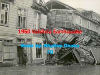
- 1. 1960 Valdivia Earthquake Made by: Rhythm Dhaka 7D
- 2. Introduction • The 1960 Valdivia earthquake or Great Chilean Earthquake of Sunday, 22 May 1960 was the most powerful earthquake ever recorded, rating 9.5 on the moment magnitude scale. It occurred in the afternoon (19:11 GMT, 15:11 local time), and the resulting tsunami affected southern Chile, Hawaii, Japan, the Philippines, eastern New Zealand, southeast Australia, and the Aleutian Islands in Alaska. • The epicentre was near Lumaco (see map), approximately 570 kilometres (350 mi) south of Santiago, with Valdivia being the most affected city. The tremor caused localised tsunamis that severely battered the Chilean coast, with waves up to 25 metres (82 ft.). The main tsunami raced across the Pacific Ocean and devastated Hilo, Hawaii. Waves as high as 10.7 metres (35 ft.) were recorded 10,000 kilometres (6,200 mi) from the epicentre, and as far away as Japan and the Philippines.
- 3. • The earthquake did not strike all the territory with the same strength; measured with the Mercalli scale, tectonically depressed areas suffered heavier damage. The two most affected areas were Valdivia and Puerto Octay, near the northwest corner of Llanquihue Lake. Puerto Octay was the centre of a north-south elliptical area in the Central Valley, where the intensity was at the highest outside the Valdivia Basin. East of Puerto Octay, in a hotel in Todos los Santos Lake, piles of plates were reported to have remained in place. • Two days after the earthquake Cordón Caulle, a volcanic vent close to Puyehue volcano, erupted. Other volcanoes may also have erupted, but none was recorded due to the lack of communication in Chile at the time. The relatively low death toll in Chile (estimated at 6,000) is explained in part by the low population density in the region, and by building practices that took into account the area's high geological activity.
- 4. Earthquake development • Global seismic release from 1906 to 2005, the graph shows that almost 25% of the world earthquake energy in a century was concentrated in the Great Chilean Earthquake alone. • A Valdivia street after the earthquake of 22 May 1960 • The 1960 Chilean earthquake swarm was a series of strong earthquakes that affected Chile between 21 May and 6 June 1960. The first was the Concepción earthquake, and the strongest was the Valdivia earthquake.
- 5. Destruction The Earthquake Occurred • The death toll and monetary losses arising from such a widespread disaster are not certain. Various estimates of the total number of fatalities from the earthquake and tsunamis have been published, with the USGS citing studies with figures of 2,231, 3,000, or 5,700 killed and another source uses an estimate of 1,655 killed, 3,000 injured, 2,000,000 homeless, and $550 million damage in southern Chile; tsunami caused 61 deaths, $75 million damage in Hawaii; 138 deaths and $50 million damage in Japan; 32 dead and missing in the Philippines; and $500,000 damage to the west coast of the United States. • Hundreds of people were already reported dead by the time the tsunami struck. One ship, Canelos, starting at the mouth of Valdivia River, sank after being moved 1.5 km (0.93 mi) backward and forward in the river; its mast is still visible from the road to Niebla.
- 6. Tectonic Interpretation • The earthquake was a mega thrust earthquake resulting from the release of mechanical stress between the sub ducting Nazca Plate and the South American Plate, on the Peru-Chile Trench. The focus was relatively shallow at 33 km (21 mi), considering that earthquakes in northern Chile and Argentina may reach depths of 70 km. Subduction zones are known to produce the strongest earthquakes on earth, as their particular structure allows more stress to build up before energy is released.
- 7. Natural disasters triggered Landslides • The earthquake triggered numerous landslides, mainly in the steep glacial valleys of the southern Andes. Within the Andes, most landslides occurred on forested mountain slopes around the Liquiñe-Ofqui Fault. Some of these areas remain sparsely vegetated while others have naturally developed more or less pure stands of Nothofagus dombeyi.These landslides did not cause many fatalities nor significant economical losses because most of the areas were uninhabited, with only minor roads. • One landslide caused destruction and alarm following its blockage of the outflow of Riñihue Lake. About 100 km (62 mi) south of Riñihue Lake, landslides in the mountains around Golgol River caused this river to dam up; when it burst through the earthen dam, it created a flood down to Puyehue Lake. The Golgol landslides destroyed parts of international Route 215-CH, which connects to Bariloche in Argentina through Cardenal Antonio Samoré Pass.
- 8. Natural disasters triggered Tsunami • Earthquake-induced tsunamis affected southern Chile, Hawaii, Japan, the Philippines, eastern New Zealand, southeast Australia and the Aleutian Islands. Some localised tsunamis severely battered the Chilean coast, with waves up to 25 m (82 ft.). The main tsunami crossed the Pacific Ocean at a speed of several hundred km/h and devastated Hilo, Hawaii, killing 61 people. In Japan, the tsunami arrived about 22 hours after the earthquake and killed 142 people. Tsunami waves as high as 10.7 m (35 ft.) were recorded 10,000 km (6,200 mi) from the epicentre, several as far away as Japan and the Philippines. • At the coastal town of Queule a carabinero reported hundreds of people to be dead or missing some days after the tsunami. Historians Yoselin Jaramillo and Ismael Basso report that people in Queule decades later know about 50 people to have died because of the earthquake and tsunami. • On 22 May, a tsunami occurred also in Nahuel Huapi Lake, on the Argentinean side of the Andes, more than 200 km away from Valdivia.
- 9. Impacts in Valdivia • It has been estimated that about 40% of the houses in Valdivia were destroyed, leaving 20,000 people homeless. The most affected structures were those built of concrete, which in some cases collapsed completely due to lack of earthquake engineering. Traditional wooden houses fared better; although in many places, they were uninhabitable, they did not collapse. Houses built upon tectonically elevated areas suffered considerably less damage compared to those on the lowlands, which absorbed great amounts of energy. • In terms of urban development, Valdivia suffered the loss of the minor but significant Cau-Cau bridge, a bridge that has not been rebuilt. The other bridges suffered only minor damage. As the earthquake destroyed Valdivia's flood barriers, general land subsidence exposed new areas to flooding. • The earthquakes damaged an area that had suffered a long period of economic decline, which began with shifts in trade routes, due to the expansion of railroads in southern Chile and the opening of the Panama Canal in 1911.
- 10. Creation of Emergency Committee • After the 1960 Valdivia earthquake, a committee was formed to solve problems caused by the earthquake. It continued to operate, to develop approaches for national emergencies. In 1974 it was named ONEMI (Spanish acronym for National Emergency and Information Office) when it was authorized by law as an independent governmental office.
- 11. Conclusion !!! Date 22 May 1960 Magnitude 9.5 Mw Depth 33 km Epicentre Lumaco, Chile 38.235°S 73.047°WCoordinates: 38.235°S 73.047°W Countries or regions Chile, Argentina, United States, Japan, Philippines Casualties 2,230 – 6,000
- 12. Bibliography • http://en.wikipedia.org/wiki/1960_Valdivia_e arthquake • http://earthquake.usgs.gov/earthquakes/worl d/events/1960_05_22.php • http://www.history.com/this-day-inhistory/huge-earthquake-hits-chile • http://www.ngdc.noaa.gov/hazardimages/eve nt/show/25