2004-09-12 Data and Tools for Air Quality Management:
110105 htap pilot_aqco_p_esip_dc
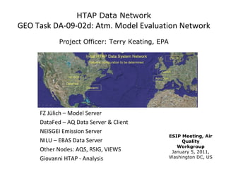
1. HTAP Data Network
GEO Task DA-09-02d: Atm. Model Evaluation Network
Project Officer: Terry Keating, EPA
FZ Jülich – Model Server
DataFed – AQ Data Server & Client
NEISGEI Emission Server
ESIP Meeting, Air
NILU – EBAS Data Server Quality
Workgroup
Other Nodes: AQS, RSIG, VIEWS January 5, 2011,
Giovanni HTAP - Analysis Washington DC, US
2. HTAP Data Network
GEO Task DA-09-02d: Atm. Model Evaluation Network
• Demonstration of a service-oriented, loosely coupled air
quality data sharing network.
• Implemented using standards and conventions for publishing,
finding and accessing distributed holdings of atmospheric
model outputs and observations.
• The main output is a portable open-source WCS data server
software and tools.
• The HTAP Pilot is a contributions to GEOSS through GEO Task
DA-09-02d: Atmospheric Model Evaluation Network.
8. Project Status on the Collaboration Continuum:
Between Cooperation and Collaboration
9. The GEO Air Quality Community of Practice
Report to ESIP AQ WG, Jan 2011, Washington DC
based on
6th Annual Meeting of Task force on Hemispheric Transport of Air Pollutants (TF HTAP)
Brussels, June 15, 2010
Report and Presentations at GEO Plenary, Beijing, November 5, 2010
Point of Contact: Rudolf Husar (rhusar@wustl.edu)
10. 2. Driving Forces for the Flow of Data
These are PULL and PUSH driving forces for the flow of data
12. Interoperability for Connecting:
Machines & Machines
People & People
People & Machines
Personal
People People
Interoperability
Phone, Video, email,
Messages RSS/Atom,
Social, Wiki
Stack
Data as Service OGC
W*S, netCDF-CF
Co-development
13. Air quality: Many Observations, Many Applications
The GEO AQ CoP aims to
connect and enable
air quality data providers
and users
for
effective air quality science and
management
13
14. Other AQ CoP Ativities
AQ CoP Participation in GEO Tasks
• US-09-01b: Development of Communities of Practice
• US-09-01a: Identifying User Requirements for Earth Obs.
AR-09-01b: GEO Architecture Implementation Pilot (AIP)
•DA-09-02d: Atmospheric Model Evaluation Network
•…..
Meeting & Coordination Activities, 2010
May 2010: GEO Decision Support Concept Proposal (Falke)
June 2010: AQ Participation in the GEOSS AIP 2,3. (Falke, Robinson)
Sep 2010: Report to UIC (Husar)
Nov 2010: Presentations at GEO Plenary, Beijing (Sethi, Menon)
Monthly: Telecons, Wiki workspace (Falke, Robinson)
15. AR-09-01b: GEO Architecture Implementation Pilot (AIP)
Testing and Using the GEOSS Common Infrastructure (GCI)
Catalog
Space Time
of
AQ Data Data Search Facets
though the Dataset Parameter Instr. Platform
GEOSS
Clearinghouse
Sharing is facilitated by the GEOSS Common Infrastructure
16. GEO AQ-CoP
Main interaction through the open, participatory website:
• CoP People
• Member Projects
• DataSpaces
17. GEO AQ CoP Poster
• What is the GEO AQ CoP?
– Self- organized group working
together to foster application of
Eos to AQ
– Rather than competing, it connects
and supports the activities of other
data integration communities and
initiatives
• CoP Activities for GEOSS
– AIP 3, AQ Community Catalog
– WCS Server Software, Co-
developed, Shared
• CoP Activities for Users
– Catalog and help access to AQ-
relevant data and tools
– Foster collaborative projects and
global-regional integration
18. GEO AQ CoP Active Participants
Technologists:
Michael Decker, FZ Julich; Oleg Goussev (DLR); Kari Hoijarvi, WUSTL; Erin Robinson,
WUSTL.. and others.
Facilitators:
Stefan Falke, NGC; Dave McCabe, EPA/CAC); Frank Lindsey, NASA; Rudy Husar, WUSTL;
Martin Shulz, FZ Juelich .. and others.
Agency Executives:
Gary Foley, EPA; Terry Keating, EPA; Lawrence Friedl, NASA .. and others.
Point of Contact: Rudolf Husar (rhusar@wustl.edu)
Hinweis der Redaktion
We will start out by highlighting significant trends in air pollution monitoring and management Next we will describe an agile information system architecture for air quality decision support Finally, we will show the application of this architecture and technologies for two use cases: a real time smoke event analysis and a long-term model evaluation
The HTAP Data Network Pilot is a demonstration of a service-oriented, loosely coupled air quality data sharing network. It is implemented using international standards and conventions for publishing, finding and accessing distributed holdings of atmospheric model outputs and observations. The portable WCS data server software and the tools developed and used in this HTAP Pilot are contributions to GEOSS through GEO Task DA-09-02d: Atmospheric Model Evaluation Network.
First a recap of tree basic ideas for GEOSS. Any single problem requires many datasets Any dataset will serve many communities The PULL by data users and the PUSH by data providers are driving forces for the flow of data
However, there are also strong impediments to the flow of data, both technological and social. A guiding principle for interoperability is “What few things must be the same so that everything else be different?” Whats the minimum set of protocols should we agree on so that we have an “Internet” for data?