1. MWL. RAHIM RASHID CHANZI …. Facebook follow us on “geography for secondary school-o level” 0713-391363
mwl rahim rashid chanzi
1
MAJOR FEATURES OF THE EARTH’S SURFACE
We are living organisms we are living on the earth’s landmass. This landmass is arising from the ocean
floor which is called a continent.
A continent is a major landmass arising from the ocean floor.
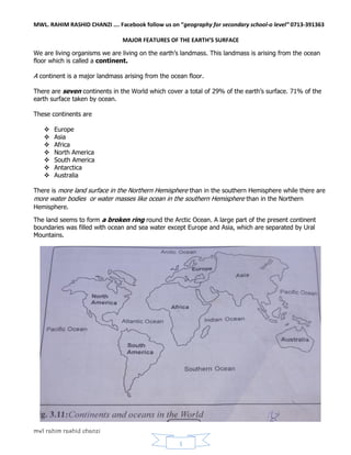
There are seven continents in the World which cover a total of 29% of the earth’s surface. 71% of the
earth surface taken by ocean.
These continents are
Europe
Asia
Africa
North America
South America
Antarctica
Australia
There is more land surface in the Northern Hemisphere than in the southern Hemisphere while there are
more water bodies or water masses like ocean in the southern Hemisphere than in the Northern
Hemisphere.
The land seems to form a broken ring round the Arctic Ocean. A large part of the present continent
boundaries was filled with ocean and sea water except Europe and Asia, which are separated by Ural
Mountains.
2. MWL. RAHIM RASHID CHANZI …. Facebook follow us on “geography for secondary school-o level” 0713-391363
mwl rahim rashid chanzi
2
THE DISTRIBUTION AND SIZE OF CONTINENTS
1. ASIA
This is the largest continents on the earth’s surface. Asia has an area of about 42.2 million square
kilometers.
Asia covers almost one third of the earth land mass, on the north is bounded by the Arctic Ocean,
on the east by the Bering Strait and the Pacific Ocean.
On south by the Indian Ocean, and on the south west is bordered by the red sea and
Mediterranean seas. On the west, the conventional boundary between Europe and Asia which is
drawn at the Ural Mountains, continuing south along the Ural River to the Caspian Sea
Then in the west it stretches along the Caucasus Mountains to the Black Sea. Many geographers
regard the land mass formed by Europe and Asia as single continent-Eurasia
Asia is attached to Africa by the Isthmus of Suez which has been constructed to form Suez Canal.
2. AFRICA
Africa is the second largest continent in the world. The continent covers an area of about 30.3
million square kilometers. It extends from 350
S to 370
N and is therefore crossed by the Tropics
of Cancer and Capricorn.
It also extends from 1500
W to 500
E. About three quarters of the area lies in the tropics. Africa is
bordered to the north by the Mediterranean Sea, to the west by Atlantic Ocean and to the east by
the Indian Ocean.
3. NORTH AMERICA
North America is the third largest continent in the world. Its covers about 24.0 million square
kilometers.
It extends from 100
N to 650
W and from 600
W to 1600
W. It is bordered to the west by the
Pacific Ocean, to the east by the Atlantic Ocean and to the North by the Arctic Ocean.
4. SOUTH AMERICA
South America is the fourth largest continent in the world. Its area is about 17.4 million
kilometers. It’s about the size of Africa continent. South America lies between 100
N and 500
S
and between 350
W and 800
W.
South America to the east is bordered by the Atlantic Ocean, to the west by the Pacific Ocean and
it joined to North America by the panama Isthmus.
5. ANTARCTICA
Antarctica is the fifth largest continent in the world. It has total area about 11.4 million square
kilometers. It’s about one- third of the size of the Africa.
The Antarctica continent lies within the latitude 600
S, it’s surrounded by the Southern Ocean.
This continent is the only uninhabited in our world. There is no rainfall in Antarctica.
3. MWL. RAHIM RASHID CHANZI …. Facebook follow us on “geography for secondary school-o level” 0713-391363
mwl rahim rashid chanzi
3
6. EUROPE
Europe is the sixth largest continent in size. It has 9.8 million square kilometers. Europe is about
two fifths of the size of Africa.
Large area of Europe lies between 400
N and the Arctic Circle and between 100
W and 600
E. It
separated from Asia by Ural Mountain to the east while North is bordered by the Arctic Ocean.
Atlantic Ocean borders Europe to the west while in south it bordered by the Mediterranean Sea.
7. AUSTRALIA
Australia is the smallest continent compared to others, its total area is about 8.5 million square
kilometers. The size of Australia continent is about quarter of the size of Africa.
Australia lies between 100
S and 400
S and between 1150
E and 1500
E. this continent also covers
the islands of New Zealand which is at the south east of Australia.
Indian Ocean borders Australia to the West and North by the Pacific Ocean. In the east and in the
south, it is bordered by Southern Ocean.
MAJOR RELIEF FEATURES OF CONTINENTS
Since the surface of all continents are not completely flat surface, it usually has slope and
altitudes which give rise to the different relief features.
These features include
Mountains
Hills
Plains
Plateaus
Rivers
Lakes
Basins
Rift valleys
The plains, plateaus and mountains form the major relief features of continents.
1. Mountains
Mountains are landforms with high relief of a height of over 300 meters above the sea level.
Types of mountains
Type of mountains are categorized on bases of their formation. There are four major types of
mountains namely; -
Volcanic mountains
Block mountains
Fold mountains
Residual mountains
4. MWL. RAHIM RASHID CHANZI …. Facebook follow us on “geography for secondary school-o level” 0713-391363
mwl rahim rashid chanzi
4
(a) Volcanic mountains
Volcanic mountains are formed from the deposition and cooling of hot molten lava and ashes that
are thrown out from the Earth’s interior after volcanic eruption.
Volcanoes are categorized into three types on the basis of extent of their eruptions.
Types of volcanoes
There are three major types of volcanoes, which are: -
1) Active volcanoes
2) Dormant volcanoes
3) Extinct (dead) volcanoes
(i) Active volcanoes
Active volcanoes are volcanic mountains which are still experiencing periodic eruptions from
time to time.
There are so many active volcanic mountains in the world. Some of these include Mount
Vesuvius, Stromboli in Italy, Krakatoa in Indonesia, and Mufumbiro in Uganda, Oldonyo
Lengai in Tanzania, nyiragongo in DRC.
(ii) Dormant volcanoes
Dormant volcanoes are those volcanic mountains which have erupted once in the past and
later on remained inactive for long period.
These are sleeping volcanoes, which may become active once again like Kilimanjaro and Meru
Mountain in Tanzania.
5. MWL. RAHIM RASHID CHANZI …. Facebook follow us on “geography for secondary school-o level” 0713-391363
mwl rahim rashid chanzi
5
Dormant volcanic mountain
(iii) Extinct (dead) volcanoes
Extinct volcanoes are those mountains which were active but have not erupted for a very long
time and not shown any sign of eruption.
These mountains include Elgon, Ngorongoro, Mount Kenya and Rungwe mountains of East
Africa.
Extinct volcanic mountain
6. MWL. RAHIM RASHID CHANZI …. Facebook follow us on “geography for secondary school-o level” 0713-391363
mwl rahim rashid chanzi
6
Most of volcanic mountains form craters at their peaks, these are normally conical in shape.
This can be found in Mount Kilimanjaro and Fujiyama.
When craters are filled with water they tend to form crater lakes like Lake Dulute and
Ngorongoro in Arusha Tanzania
(b) Fold Mountains
These are kind of mountains which are formed by the bending of the earth’s crust stratified rocks
due to compressional forces.
Stratified rocks are the kind of the rocks which are formed in strata (layer) of aggregate rocks
such as sedimentary rocks.
Fold mountains usually of high parallel ranges which extend several kilometers across the
continent.
The formation of Fold Mountains is influenced by compressional forces which lead the formation
of fold.
A fold is a wrinkling stretch with an anticline (up fold) and syncline (down fold) produced by
compressional forces.
Fold Mountains are: - Cape Ranges in South Africa, Mount Everest in the Himalaya, Rockies in
North America and Alps in Switzerland.
(c) Block mountains
Block Mountains are formed by faulting process in the crust. The faults cracks are triggered by
tensional forces to produce a block mountain.
Sometime the faulting become the result of compressional forces the form of Block Mountains will
be a Horst.
Block Mountains includes mount Vosges in and black forest in Europe, Usambara, Ruwenzori,
uluguru and Drakensberg in Africa.
7. MWL. RAHIM RASHID CHANZI …. Facebook follow us on “geography for secondary school-o level” 0713-391363
mwl rahim rashid chanzi
7
(d) Residual Mountains
Residual mountains are formed when prolonged denudation lowers mountains and other
landforms by removing the weaker rocks, but the more resistant rocks remains. The mountains
which remains are called Residual Mountain.
Residual mountains occur in many parts of the world like central Africa where they form
prominent landforms on the plateau surface.
The major agents of this denudation are water, wind, ice, animal and human activities. Residual
mountains also known as mountains of denudation.
There are so many residual mountains in the world like: -
Sekenke – singida Tanzania
The Scotland highland in Europe
Adamawa mountain in eastern Nigeria
The messas and Buttes in United States
The sierra in sieral in central Spain.
A Valley
Valley is a longer and narrow depression in the land surface often occupied by river.
Valley is caused by erosion carried on by the running.
Rift Valley
It is a long, deep valley bounded by normal faults. It is formed where the crust of the Earth is being
pulled apart.
A rift valley can appear on land or beneath water bodies, where two continental plates are separating, or
on the ocean floor along the crest of a mid ocean ridge.
Fault
Is a fracture or crack that develop in the crust due to pressure exerted on it by compressional or
tensional forces.
Rift valley occur in association with Block Mountains
The most impressive rift valley in the world is the East African rift valley, it’s known as the Great Rift
Valley of Africa
It extends for over 7200km of which 5600km is in Africa.
Rift valley cover large area includes Mozambique, northwards through Ethiopia in the red sea, Gulf of
Suez and Gulf of Aqaba in Jordan and at Lake Malawi
In east Africa rift valley passes through the lake magadi, Lake Turkana, Lake Albert, Lake Tanganyika,
Lake Nyasa etc.
BASINS AND DRAINAGE SYSTEMS
A basin is the form of natural or artificial depression varying in size on the earth’s surface. Sometime
basin occupied by water. Hence, they form rivers, lakes and ocean basin.
There are number of basins in Africa such as Lake Victoria basin, Congo basin, El Djouf basin, chad basin
and Sudan basin
8. MWL. RAHIM RASHID CHANZI …. Facebook follow us on “geography for secondary school-o level” 0713-391363
mwl rahim rashid chanzi
8
Drainage
Drainage is the removal of water from land surface. Rain water on the land surface can be removed by
various ways.
Overland flow is the flow of water on the ground after not being evaporated.
Underground flow is the percolating of water into the ground and finale find its ways to the
surface
Run-off is the surface flow of water from rainfall or snow over the ground.
The surface water from rainfall or snow-melts flow in small channel which finally join together to form
large streams of river.
The smaller river or streams that join to form large streams of a river are called tributaries. The small
streams that branches off before it enters the sea or lake are known as distributaries.
The area from which a river system collects its rainwater is called river basin, catchment area or
drainage basin.
The boundary between one catchment area and the next is usually formed by the crest line of the
surrounding highlands called watershed, water divide or basin perimeter. The main river and all its
tributaries together form a river system.
Water flow down the slope due to gravitational force. Flowing water carries mineral in solution, rock
sediments and organic matter. Material deposited to the end of running water like sea. In Africa Congo,
Niger and Orange Rivers flow into Atlantic Ocean. Zambezi and Limpopo flow into Indian Ocean. Once
water in the lakes does not flow to the sea may form inland drainage.
WATER BODIES
Water bodies are the areas on the earth’s surface covered by water. Those area includes
(i) Oceans
(ii) Seas
(iii) Lakes
1. Oceans
An ocean is a large body of water that surrounds the landmass of the earth. In the World Ocean and sea
cover almost 360 kilometers. They take 71% of the earth surface. There is more water in the southern
hemisphere than there is in northern hemisphere.
MAJOR FIVE OCEANS IN THE WORLD.
1. Pacific Ocean
2. Atlantic Ocean
3. Indian ocean
4. Arctic ocean
5. Southern Ocean
Pacific Ocean
The Pacific Ocean is the largest ocean in the world. It’s occupies about 165.3 million square kilometers.
9. MWL. RAHIM RASHID CHANZI …. Facebook follow us on “geography for secondary school-o level” 0713-391363
mwl rahim rashid chanzi
9
Atlantic Ocean
Atlantic Ocean is the second largest ocean in the world with an area of about 82.2 million square
kilometers
Indian ocean
Indian Ocean is the third largest ocean in the word. It occupies an area of about 73.4 million square
kilometers.
Southern Ocean
Southern Ocean is the fourth largest continent in the world. With an area of 20.5 million square
kilometer. It encircles the continent of Antarctica.
Arctic ocean
The Arctic Ocean is the fifth largest ocean in the world. With an area of about 14.0 million square
kilometers.
Ocean water contain mineral salts like sodium chloride and calcium carbonate. They are there as a result
of accumulation since the formation of ocean as well from volcanic activities on water and those derived
from land by river, wind and ice.
Factors influence saltiness or salinity in ocean water
There is high variation of saltiness of the ocean water some area is high while other area is low. Hence
saltiness of the sea is not the same in all places. This is due to:
1. Available temperature in the ocean area. Lead to high salinity due to high evaporation
2. Availability of fresh water from rainfall, river and melting ice.
3. Rate of evaporation
4. The ocean currents
WATER MOVEMENT IN THE OCEAN
Ocean water is constantly in motion. Wind is the cause of ocean currents; Earth’s rotation and the shape
of land masses influence the direction of ocean currents.
Oceans exhibit three major forms of water movement: ocean currents, tides and waves.
Type of ocean movement
1. Horizontal movement
This is the movement of water in the ocean in form of ocean currents and tides.
2. Vertical movement
This is the movement of water in the ocean by rising of sub-surface water and the sinking of
surface water.
Ocean currents
Ocean current is the movement of surface water in the ocean.
10. MWL. RAHIM RASHID CHANZI …. Facebook follow us on “geography for secondary school-o level” 0713-391363
mwl rahim rashid chanzi
10
Ocean current of warm and light water flows from the equatorial region toward the polar region and a
cold current flow from the cold polar region to the warm equatorial regions.
TYPE OF OCEAN CURRENTS
1. Warm ocean currents
These are ocean current that originate near the equator and flow toward the poles.
Example of warm ocean currents are Mozambique, Kurosiwo, Brazilian, Gulf Stream and
guinea.
2. Cold ocean currents
These are ocean currents that originate in the high latitudes and flow toward the equator.
Example of cold ocean current are Benguela, Peruvian, California, Labrador, canaries and
Kamchatka.
CAUSES OF OCEAN CURRENTS
1. Moving winds (prevailing wind)
2. Rotation of the earth
3. The shape of the continents and ocean bed (floor)
4. Different of density and temperature of ocean water
5. Salinity of the ocean
Tides
Tides are the periodic rise and fall in the level of water in ocean and sea in response to
gravitational forces.
It usually occurs twice a day. Once it rises to the highest level it falls to the lower level too. Tides
become high during the eclipse.
CAUSES OF TIDES
1. The effects of gravitational force exerted by the sun and moon on the earth’s surface.
The sun and the moon exert a gravitation attraction on the earth’s surface which causes a rising
and falling motion to develop in larger ocean. This kind of motion produces tides.
Waves
Waves are up and down movements of the surface water.
11. MWL. RAHIM RASHID CHANZI …. Facebook follow us on “geography for secondary school-o level” 0713-391363
mwl rahim rashid chanzi
11
PARTS OF WAVES
1. Crest
2. Trough
Crest
Crest is the highest part of the wave.
Trough
Trough is the lowest part of the wave
The distance between one crest to the next or from one trough to the other is known as wavelength.
Waves travel in definite direction.
CAUSES OF WAVE
1. Moving wind
2. seismic or volcanic activity (tsunamis)
The height and the power of the wave depend on
1. Strength of the wind
2. Distance of open water over which the wind blow.
The stronger the wind, the greater the fetch, the more powerful the wave.
Fetch is the distance of open water across which the wind can blow without interruption
The ocean floor
The relief of the ocean flow is varying as that of the land surface. It is irregular in shape.
Features of the ocean floor
There are five main relief features of the ocean floor namely: -
1. Continental shelf
2. Continental slope
3. Deep sea plains
4. Ocean ridge
5. Ocean deeps or trenches
12. MWL. RAHIM RASHID CHANZI …. Facebook follow us on “geography for secondary school-o level” 0713-391363
mwl rahim rashid chanzi
12
ocean island is also regarded as feature of ocean floor.
(a) Continental Shelf
Continental shelf is a gently sloping of margin of a continent. It is shallow part of the sea or
ocean. Continental shelf occupied by shallow water that extends from the coast deep toward to
the ocean margin.
(b) Continental slope
Continental slope is a steep slope that extends from the edge of the shelf to the deep see plain.
(c) Ocean ridge
An ocean ridge is the raised part of the ocean floor. It takes a form of ridge or plateau. Example
of this is mid-Atlantic ridge. Sometime rises above the surface to form oceanic islands.
(d) Deep Sea Plains
Deep sea plain is wide gently undulating or fairly level surface which have depth between 2000m
to 3000m.
(e) ocean deep or Trenches
Ocean depth or trenches are long, narrow depressions found on the ocean floor.it occurs on the
edge of the continents. For example, mariana trench and Atacama trench.
LAKES
A lake is a hollow on the Earth’s surface in which water collected. Most of the lake are permanent
but others are temporary.
Example of lake in East Africa area Lake Nyasa, Victoria, Tanganyika, Albert, Turkana, Eyasi,
Natron, Kivu and Edward, Ngozi, Magadi and kyoga.
SEAS
Seas are the narrow inlet and outlet between two oceans which are extensive in size. There are
several seas on the Earth’s surface which includes:
1. Caribbean Sea
2. Mediterranean Sea
3. Bering sea
4. North Sea
5. Caspian Sea
6. Dead sea
7. Aral Sea
8. Red sea