Situational Awareness Workgroup Input
•Als KEY, PDF herunterladen•
2 gefällt mir•536 views

Draft input into the FEMA Situational Awareness workgroup who is supporting the National Level Exercise (NLE) 2011. More information on this workgroup visit http://wiki.crisiscommons.org/wiki/Situational_Workgroup

Empfohlen
Empfohlen
Weitere ähnliche Inhalte
Andere mochten auch
Andere mochten auch (10)
Ähnlich wie Situational Awareness Workgroup Input
Ähnlich wie Situational Awareness Workgroup Input (20)
Mehr von Heather Blanchard
Mehr von Heather Blanchard (20)
Kürzlich hochgeladen
Kürzlich hochgeladen (20)
Situational Awareness Workgroup Input
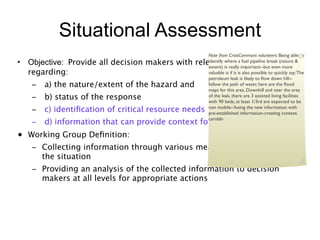
- 1. Situational Assessment Note from CrisisCommons volunteers: Being able to • Objective: Provide all decision makers with relevant information identify where a fuel pipeline break (nature & extent) is really important--but even more regarding: valuable is if it is also possible to quickly say: The petroleum leak is likely to flow down hill-- – a) the nature/extent of the hazard and follow the path of water, here are the flood maps for this area. Downhill and near the area – b) status of the response of the leak, there are 3 assisted living facilities with 90 beds, at least 1/3rd are expected to be – c) identification of critical resource needs non mobile--fusing the new information with pre-established information-creating context. caroldn – d) information that can provide context for decision making • Working Group Definition: – Collecting information through various means which is relevant to the situation – Providing an analysis of the collected information to decision makers at all levels for appropriate actions
- 2. Metrics and Goals Tasks •Fully engage the entire public and impacted communities, to include survivors, people who communicate in different languages or methods, organizations, and volunteers, in accomplishing all aspects of situational assessment – Obtain information from many sources: NGOs in the field, news organizations, crisis-mappers, existing risk and vulnerability assessments and local plans, text message feed, other social media sources, etc. •Analyze incoming data and information so that it is vetted and validated. – Conduct assessments by any means possible, and utilize all social media and communications tools available to speed up and enhance: • Initial hazards/damage projections and associated threats to people • Essential life-saving resources required and delivery alternatives • Empirical data “ground truth” regarding all significant threats • Ability to reach out and engage with people who do not communicate in English, or do not use technology. •Establish information “channels” by which filtered information is passed to decision-makers “of whatever stripe”. – A common operating picture is developed with timely paths to share with all. •Establish “feedback” loop in order to determine if information has been received and acted upon. Note from CrisisCommons volunteers: •I would think one of the first tasks maybe even an objective (since it is such a large area) would be to determine those MOST impacted (e.g. triage--what area needs the most help) —kim26stephens 22
- 3. Metrics and Goals Metrics: •Impacted communities and survivors have the capacity to receive critical life-saving information within 1 hour, either by technical or non-technical means •Initial assessments of impacted area(s) delivered to on-site and local response elements, local governments and to the impacted population/survivors within 1 hour •Initial assessment of resources available in the impacted area in multiple languages, to save and sustain lives within 4 hours •Common Operational Picture updated hourly, beginning within 4 hours, and disseminated to all stakeholders •Empirically based life-saving products within 8 hours Note from CrisisCommons volunteers: •“Initial assessments of impacted areas...delivered to...local response elements...within 1 hour” HIGHLY skeptical that meaningful and actionable data would be pushed to the locals. It would most likely be the other way around, and they would be pushing groundtruth information up to the state/feds. Suggest the metric be reversed, and that the conduit established and supported to allow for clear, accurate and rapid assimilation of assessment information from state/local agencies, especially if you have an aggressive 1 hour window. —chiefb22enator •Metric Bullet 3: “resources available”: from where? I added impacted area, but locals will want to know what resources are on there way.e.g. those outlined in the assumptions. —kim26stephens 33
- 4. How To’s • Tasks: • Leverage the potential of emergency information that is being shared and communicated by the affected communities and turn it into actionable data that can improve the real-time situational awareness of the local, state and national response communities. • Fully engage the public and impacted communities, to include survivors, organizations, and volunteers, in accomplishing all aspects of situational assessment – Conduct aggressive outreach to these groups through the use of common social media, soliciting their information and sharing what is known/emerging from official and non-official sources, – Push information being received from non-impacted areas to States/Regions with damaged communications infrastructure – Utilize existing or emerging technologies (explain) to plug gaps in communications in impacted areas • Conduct assessments by any means possible, and utilize all social media and communications tools available to speed up and enhance: – Initial hazards projections and associated threats to people – Essential life-saving resources required and delivery alternatives – Empirical data “ground truth” regarding all significant threats – Common operating picture and timely paths to share with all – Status and needs of traditionally underserved population groups. – Important demographic information: identification of languages being used in affected area, functional and access needs, access to technology of population, the number of children , adults and pets who may be seperated from caregivers. • Receive and analyze information (both official and non-official) to create maps and Common Operating Picture for decision-makers and the public. 44
- 5. Current Assets and Capabilities 1. Incident (and Local Government) Level: • Surviving emergency services comms (radios, cell phones, internet, telephone) • Available social media (used by general public) • Private sector/volunteer organizations (ARES/RACES)/commercial businesses 1. State Level: • Emergency back-up comms (radios, satellite phones, et al) • Accessing available social media (internet), public news media, etc. 1. Regional Level: • Resilient comms (FNARs, liaisons at State-level) • Public Switched Network • Cellular • Social media 1. Federal National Level: • USGS – sensors, satellites, field offices • Departments & Agencies – field offices, resilient comms (radios, back-up power) • Imagery – aerial, satellites • Social media • Standard reporting systems – WebEOC, etc.
- 6. Critical Mission/Essential Tasks • Slide 4: CoG: Fully engage the public and impacted communities, to include survivors, organizations, and volunteers, in accomplishing all aspects of situational assessment. Critical Mission/Essential Tasks #1. Conduct aggressive outreach to these groups through the use of common social media, soliciting their information and sharing what is known/emerging from official and non-official sources with a special emphasis on groups that are harder to reach, and harder to communicate with. #2. Push information being received from non-impacted areas to States/Regions with damaged communications infrastructure #3. Utilize existing or emerging technologies (explain) to plug gaps in communications in impacted areas 66
- 7. • Assumptions May be good to add the assumption that states will have declared ◦ Immediate actions are going to be taken by FEMA and other Federal Agencies prior to emergencies and likely begun mobilizating NG resources as Kim Disaster Declaration a formal Presidential notes below. —chiefb22enator • Can we■ assume states will activate also Expecting an expedited PDD similar to 9-11 • I agree with Kim on this. Google and other robust social ■ Selected Teams (e.g., US&R, MERS, et al) media analytics will be in play very early on, and could the national guard and their communications assets. "mobile sat. will begin alert/notification/deployments at direction of Administrator communications for disaster be-should be leveraged to help ramp up SA ASAP. — response"—kim26stephen chiefb22enator • ■ Unified Area Coordination Group (UACG) willcould also “assume” that groups other than For education of CrisisCommons, can • I think we prepare/deploy ◦ learn what National-level we Current Pre-Scripted Mission Assignment (PSMA) catalog is inadequate (not social gov. will be collecting and aggregating data from communications are available, and how media onto visualization platforms. —kim26stephens structured) to meet task requirements • Why critical to research & gather data that already many channels? 1500 USAR teams ◦ All need to be deployed, and alone will Mission Assignments (MA’s) in first 72 hours will collaboratively target gaps per identified exists then come from FEMA National areas via SCIRR as requested D Dawson 10,000 shelters... —alexrosela Headquarters for national assets ■ Regions effective status unknown ■ First 72 hours to focus on notifying, mobilizing, and begin deployment (of teams, capabilities, etc) to impacted area(s) ◦ Not all jurisdictions (local, tribal, State, Region) will be without power or communications means (back-ups exist, but will have limitations) ◦ National-level communications means are resilient enough to provide basic voice communications ◦ Unofficial reporting through social media will be initial sources of real-time, on-the- ground information means for assessments ◦ Communities will have their existing emergency plans, Hazard Identification and Vulnerability Analysis available electronically. 7
- 8. Problem Statement or Deltas Problem Statement: Situational Assessment: 1. How to obtain real-time information on the status of (list of EEIs/CIRs) in a communications constrained environment; 2. Distribute relevant analysis of that information to the appropriate audiences (National leadership, State, Regions, local and tribal governments, general public, private sector partners, commercial businesses, and volunteer community) effectively within the designated time-frame (initial hours, 24, 48, and 72 hours post-event)
- 9. Recommended CIRs/EEIs Slide 6: Recommended CIRs/EEIs [Note from Heather B: What we sent them previously here]] ◦Impact to population (casualties) ◦Damage to infrastructure ■ Hospitals and other medical facilities ■ Power, communications, other energy sources ■ Law enforcement and other emergency services ■ Transportation (bridges, rail, airport towers/runways, etc.) ◦Impact on population ◦To what extent have hazardous materials been impacted? ◦Nexus of impacts to national infrastructure ◦Status of: ■ Building(s) ■ Shelters ■ Mass Care: Feeding, Distribution points ■ Non profit Activities/Resources ■ Water, sanitation, hygiene ■ Access to Medical Care, critical health services (like dialysis), prescription renewal ■ Status of non sheltering population ■ Notes: •Also which local/state EOC’s are not operating —alexrosela •Only 10% of the population usually go to shelters, people who don’t seek help are left out of many planning models--that can be 90% 9
- 10. Problem Statement or Deltas Deltas (Gaps) • Lack of a formal policy re using social media for emergency management – situational assessment/ awareness • No procedures for analyzing information received from atypical sources (social media, etc.) into actionable intelligence for use by decision-makers
- 11. Deltas (current capability vs. need) Deltas •Compiled and aggregated data from crisismapping could and should feed into the updating of datasets after a crisis, complementing timely efforts by ESF leads to update this information. See http://ict4peace.org/updates/connecting-crisismapping- to-the-united-nations ◦Crisismappers could add value by helping extract useful information or assessment data that can be made into actionable items. •Need to establish a methodology for virtual data aggregation. (A need have data in a format that can be used for both response and recovery). ◦Recovery starts moment incident happens: need to harness information for recovery to establish basis for PA and IA. This will speed up recovery process. (Can use social media to possibly establish needs.) •There are not clear standards across all organizations for data collection or data management. (For ex: One state may define a nursing home patient different than another state). Interoperability: need for open APIs (for example,Virtual USA). ■ All of the available data is not coordinated: ex: feeds from cameras on the scene--currently there isn’t adequate coordination in the EOC(s) with all of the data streams. (Some of this information is available in the public stream, large portions are “behind the firewall”. If more information was publicly available more eyes could help process it.) •Trust: Emergency management/response organization cultural barriers/political barriers: There is a significant problem with trust of the information coming from social media and crowdsourced crisis maps. •Trust: Also, there is a problem with locals not wanting to give up the information. From Paul Currion (ICT4Peace): “Organizations continue to act as if the value in data is how much of it you can hoard, rather than how much of it you can share.” ◦How do we make sure that there is value in interoperable data sets so that all levels are “talking” so that the issue of trust is minimized. For example, States are pressed to provide info up the chain and have to “pester” locals who are busy with responding. How can we take the pressure of that transfer of information: automated on the scene “pushes of data”. •Private sector data--(ex: UPS and Fedex have information on infrastructure and it will be important to include their datasets). Data patterns provide broad clues to needs of communities. 11
- 12. Situational Assessment: Critical Tasks • With advancement of personal communications devices, citizens utilize a multitude of communications networks to provide and receive information. Historically these communications channels have not been utilized in gaining information for Situational Assessment nor as a tool to provide information to the public before, during, and after a disaster. These atypical networks should be used to obtain real-time information on the status of list of EEIs/CIRs in a communications constrained environment. 1. NLE Submission #1 – In addition to normal communications networks, utilize social media (Facebook, Twitter, TwitPic, etc.) and other third party sites or communications tools, obtain relevant information to assess the impact, and to utilize FEMA social media accounts to provide timely and accurate life-saving information to affected survivors.
- 13. Critical Tasks (cont’d) Situational Assessment: • In an environment where conventional voice, data, video infrastructure networks are compromised, to effectively analyze and provide accurate and timely situations assessments within the designated timeframes (initial, 24, 48, 72 hours post-event) to the appropriate audiences (National Leadership, State, Regional, and Tribal governments, general public, private sector partners, commercial businesses and volunteer community) will require use of nontraditional communications means. 2. Establish immediate communications with all FEMA Regions, and Regions to States, using nontraditional communications means (satellite phones, VSATs, etc.) to obtain and provide initial situational and ongoing assessments of impacted area.
- 14. Way-Forward Slide 10: Way Forward •From ICT4Peace: “Almost all decisions are made from sitreps. Unstructured data is still the most common form of reporting and analysis... ◦How can the volunteer crisismapping community help with regard to performing a filtering and aggregation role?’ (From Nigel Snoad). ■ Similarly: How does the crisismapping community build more rigorous quality assurance and demonstrate value-added to the skeptical response community? By making data analysis more automated and by using computer processing tools that give value and quality to the data such as Swiftriver. 14
Hinweis der Redaktion
- Standard verbage from the WOC documents\n
- \n
- \n
- \n
- \n
- \n
- \n
- \n
- \n
- \n
- \n
- \n
- \n
- \n
- \n
- Standard verbage from the WOC documents\n
- Red indicates the basic approach to completing the tasks as currently listed\n
- Assumptions are based on the information developed during the analysis of how such an event is expected to play out within the first 72 hours; \n
- \n
- This is a summary of the expected information requirements coming from senior leadership during the first 72 hours; focusing on the mission set of: saving lives, mitigating suffering, and preventing further damages.\n
- \n
- \n
- \n