Survey instruments
•
1 gefällt mir•1,200 views

For support of land surveyors who use Sokkia equipment on http://landsurveyorsunited.com/group/sokkiasupportgroup

Empfohlen
Weitere ähnliche Inhalte
Was ist angesagt?
Was ist angesagt? (20)
Andere mochten auch
Andere mochten auch (13)
Ähnlich wie Survey instruments
Ähnlich wie Survey instruments (20)
Mehr von Land Surveyors United Community
Mehr von Land Surveyors United Community (20)
Kürzlich hochgeladen
Kürzlich hochgeladen (20)
Survey instruments
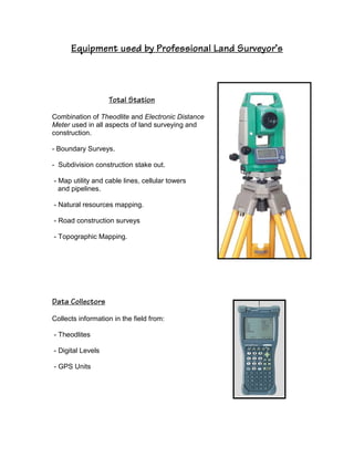
- 1. Equipment used by Professional Land Surveyor’s Total Station Combination of Theodlite and Electronic Distance Meter used in all aspects of land surveying and construction. - Boundary Surveys. - Subdivision construction stake out. - Map utility and cable lines, cellular towers and pipelines. - Natural resources mapping. - Road construction surveys - Topographic Mapping. Data Collectors Collects information in the field from: - Theodlites - Digital Levels - GPS Units
- 2. Global Positioning System – GPS - Boundary Surveys. - Subdivision construction stake out. - Map utility and cable lines, cellular towers and pipelines. - Natural resources mapping. - Road construction surveys - Topographic Mapping. Handheld GSP Unit - Facility Mapping - Environmental Mapping - Land Management - Construction - Forestry - Agriculture
- 3. Level Planer - Area/perimeter measurement - Construction site measurement - Indoor/Outdoor space planning - Golf course planning