
Empfohlen
Empfohlen
Weitere ähnliche Inhalte
Was ist angesagt?
Was ist angesagt? (20)
Andere mochten auch
Andere mochten auch (20)
Ähnlich wie Madrid’s metro system map (2008)
Ähnlich wie Madrid’s metro system map (2008) (20)
Mehr von Juan Archanco
Mehr von Juan Archanco (19)
Kürzlich hochgeladen
Kürzlich hochgeladen (20)
Madrid’s metro system map (2008)
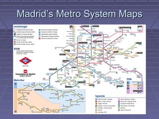
- 1. Madrid’s Metro System Maps
- 2. KEYFACTS Started operating in 1919 (King Alfonso XIII) Oldest: London (1863) # Lines: 13 (1st NYC with 26) # Stations: 231 (5th, 1st NYC with 422) Length: 283 Km (3rd, 1st London with 408) Total Passengers (2007): 690 millions (14th , 1st Tokyo with 1916 millions) Has grown from 114 Km in 1995 to 283 Km in 2007 (169 New Km in 12 years ~ 14,1 New Km/Year)
- 3. Table of Comparison “Old” Map New Map Respects Yes No distances Sense of reality Good Bad Ease of use Good ¿Very? Good Appearence Nice ¿Nicer?
- 4. Who’s behind the maps? “Old” Map: New Map: Comunidad de Madrid & CTM Rafael Sañudo (consejeria de transportes e infraeestructuras)
- 5. Questions Who is the author? What kind of map is it? What is the map’s purpose? Who is the audience? Is it possible to misinterpret the map? What may improve the map?
- 6. QUESTIONS FOR THE CLASS What may improve (an underground network) map? What makes a good (underground network) map?
- 7. Links & Sources http://www.20minutos.es/noticia/224418/0/plano/metro/debate/ (new map article) http://www.skyscrapercity.com/showthread.php?t=463947 (survey #1) http://www.20minutos.es/minuteca/metro-de-madrid/ (survey #2) http://urbanity.blogsome.com/2005/12/30/metro-de-madrid-evolucion-historica/ (evolution of the network) http://www.esmuz.net/blog/2005/01/el-plano-de-metro.html (subway’s maps from the point of view of a graphic designer) http://www.20minutos.es/galeria/2347/0/0/ (photogallery) http://en.wikipedia.org/wiki/Harry_Beck_(graphic_designer) http://www.20minutos.es/noticia/224865/0/nuevo/mapa/metro/ (Madrid’s new metro map designer) http://www.raro.net/ (Madrid’s new metro map designer’s website) http://www.new.facebook.com/profile.php? id=517815832&ref=mf#/group.php?gid=25126229252 (Facebook group agains the new map)