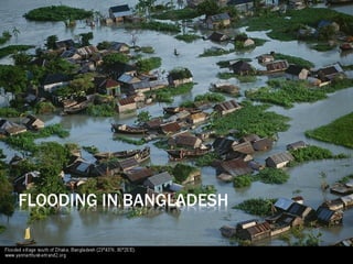
SlideShare ist ein Scribd-Unternehmen logo
1 von 22
   https://www.youtube.com/watch?
    v=DK0dnecgSFU

   http://www.bartholomewmaps.com/physical_coun
    tries.html

   Google Earth

   Major floods 1988,1998, 2004 and 2010.
   It is one of the world's most densely populated countries!
   It has a population of 125m inhabitants
   It is one of the poorest countries in the world with a GNP of
    $200 per head
   It has three of the world's most powerful rivers passing through
    its country - The Ganges, the Meghna & the Brahmaputra
   It contains virtually no raw materials or rock!
   It experiences floods and tropical storms every year.
   Physical Reasons      Human Reasons
3 mighty rivers!
Ganges    (Padma)
Meghna
Jamuna     (Brahmaputra)

A confluence between the Ganges
and Jamuna to the West of Dhaka is
a flash point for flooding.

80% of the water in these rivers
falls or melts outside Bangladesh in
neighbouring countries!
   The monsoon is a wind
    that brings with it low
    pressure moist air from
    over the Indian Ocean
    and therefore heavy rain.
•   Total rainfall within the Brahmaputra,
    Ganges – Meghna catchment is very
    high and very seasonal. 75% of
    annual rainfall occurs in the monsoon
    between June and September.
•   Annual rainfall total in Dhaka is
    almost 2000mm (Hertfordshire
    900mm).
•   Tropical cyclones from Bay of Bengal
    bring heavy rain and storm waves in
    late summer.
   Every spring snow begins to
    melt in the Himalayas. This melt
    water flows into streams and
    eventually into the Ganges and
    other rivers.
   Snow melts in the spring
    causing river levels to rise.

   Heavier than expected snow fall
    or warmer than expected
    springs can lead to higher than
    expected river levels.

   Snow melt is closely monitored!
   80% of Bangladesh is located on
    the delta.
   The low level of the delta land
    means that large areas are prone
    to flooding.
   75% of Bangladesh is at or below
    just 10 metres in height.


   http://www.bartholomewmaps.com/
    physical_countries.html
   Tidal currents naturally force
    water northwards in the
    Indian ocean.

   Subtropical location (warm
    seas) means cyclone
    (hurricane) activity is
    common!

   Incoming high tides in the
    spring block water trying to
    leave the river delta!
   Deforestation may be partly to blame, stripping the land bare of the vital top soil
    which slows and drains water. This causes soil erosion which reduces the ability of
    the land to absorb water.

   Irrigation for farming is a factor, because this causes river channels to silt up,
    reducing their capacity to hold flood waters. According to some experts, irrigation
    interferes with river drainage into the sea.

   Climate experts also believe global warming is partly to blame, by increasing
    monsoon rainfall and speeding up the melting of Himalayan snows.

   Urbanisation leads to less infiltration and increased runoff.

   Dam building in India has slowed down water running through Bangladesh. This
    leads to more deposition in the river channel and less room for water!
   https://www.youtube.com/watch?
    v=wanGCUT8FG4

   Also drought in the dry season if less
    snow has fallen in the moutnains!
   Over 57% of the land area was flooded
   Over 1300 people were killed
   7 million homes were destroyed
   25 million people were made homeless
   There was a serious shortage of drinking water & dry food
   Diseases spread such as bronchitis and cholera/diarrhoea
   As the waters receded - it left fields of rotting crops,
    wrecked roads and bridges and destroyed villages
   2 million tonnes of rice was destroyed
   1/2 million cattle and poultry were lost
   Overall the floods cost the country almost $1 billion
floods occurred July to Sept         Airport, roads and railways
                                     flooded
July 2004 - 40% Dhaka was under
                                     Bridges destroyed
water
                                     $7billion damage
60% of country was flooded           Rice crop destroyed along with
                                     food supplies – vegetables
600 reporte deaths
                                     Cash crops – jute and sugar
20 million homeless
100,000 in Dhaka suffered from
diarrhoea as floodlwaters left mud
and sewage
35cm of rain fell in 1 day on 13th
Sept
Death toll rose to 750
During the monsoon, between 30% and
    50% of the entire country is flooded.
    The flood waters:
   Replenish groundwater reserves
   Provide nutrient rich sediment for
    farming
   Provide fish
   Reduce the need for artificial
    fertilisers
   Bangladesh GNP US$ 380 per capita
   Short term         concern is always for health survival and
    suffering of people affected.
   A heavy reliance is placed upon emergency aid – food, drinking
    water medicines, plastic sheets, boats
   Assistance is provided from United Nations, governments,
    charities
   Problem is distribution because so much of the country is
    underwater.
   As flood water recedes it is easier to set up medical treatment
    centres, distribute water purification tablets and provide help
    with repairing homes and restarting economic activities
In 1989  the government of Bangladesh began working with a number of
   international agencies to produce a Flood Action Plan. This huge
   scheme contained 26 action points which it was hoped would provide a
   long term solution to the country's flooding problems.

Short Term Management
 Boats to rescue people
 Emergency supplies for food, water, tents and medicines
 Fodder for livestock
 Repair and rebuild houses, as well as services such as sewage etc
 Aid from other countries

Long Term Management
  Reduce Deforestation in Nepal & Himalayas
  Build 7 large dams in Bangladesh to store excess water $30-$40 million
   and 40 yrs to complete
  Build 5000 flood shelters to accommodate all the population
  Build 350km of embankment - 7 metres high at a cost of $6 billion to
   reduce flooding along the main river channels
  Create flood water storage areas
  Develop an effective Flood Warning Scheme
How have decision makers respond to the flooding?
The Flood Action Plan (FAP) was set up in 1990 supported by several wealthy
countries and the World Bank. Its aim was to reduce the impact of the
floods that occurred annually in Bangladesh.

The FAP’s objectives were to set up regional planning groups to study and
monitor local river processes, followed by hard engineering aproaches. This
involved the construction of 3,500km of coastal and river embankments to
protect the land and to protect from storm surges brought by cyclones.
The project included building seven large dams partly to stop water from
reaching the land and to provide up to 15 floodwater storage basins.
Millions of dollars of aid were poured into the engineering projects but the
scheme remains unfinished due to corruption and inadequate funding.

As a result the FAP is not considered to have been a complete success.

Over 3 million people have been killed by coastal flooding in the last 30 years.

The first findings of the FAP in 1995 stated that, while the flood protection
scheme was economically desirable for urban areas, it was not a good idea in
rural areas, which are dependent upon fishing and farming .
What issues are faced in implementing
   strategies in countries like Bangladesh?
 Whilst the embankments have been strengthened,
 increased in height and extended in many places, the
 FAP has come across several problems, such as:


1. The Bangladeshi Government cannot afford the high maintenance costs of
   the scheme
2. The embankments are at risk of erosion from the rivers
3. River channelisation by FAP embankments has increased the risk of flood
   damage for downstream areas
4. An estimated 8 million people were forced to move due to the FAP. These
   were people who relied on farming and fishing to support themselves.

                                                         BBC Bitesize
   People have suggested that Bangladesh
    really needs a mixture of strategies
    involving flood forecasting and early
    warning schemes together with more well
    stocked flood shelters.
   These projects would be cheaper and
    more appropriate for farming and fishing
    communities in rural areas and would be
    more in keeping with local knowledge,
    skills and income levels and thus more
    sustainable. They would also have the
    advantage of being less likely to damage
    the ecosystems.

Weitere ähnliche Inhalte

Was ist angesagt?

Flood Hazards: A Case Study of the Floods in Bangladesh, Asia
Flood Hazards: A Case Study of the Floods in Bangladesh, AsiaFlood Hazards: A Case Study of the Floods in Bangladesh, Asia
Flood Hazards: A Case Study of the Floods in Bangladesh, AsiaUniversität Salzburg
 
Forest Resources of the World and Bangladesh
Forest Resources of the World and BangladeshForest Resources of the World and Bangladesh
Forest Resources of the World and BangladeshRifatBinHossain2
 
Presentation on river system of Bangladesh
Presentation on river system of BangladeshPresentation on river system of Bangladesh
Presentation on river system of BangladeshJaforJr
 
Bangladesh Climate Vulnerability: Floods and Cyclones
Bangladesh Climate Vulnerability: Floods and CyclonesBangladesh Climate Vulnerability: Floods and Cyclones
Bangladesh Climate Vulnerability: Floods and Cyclones2020resilience
 
Floods 130611112734-phpapp01
Floods 130611112734-phpapp01Floods 130611112734-phpapp01
Floods 130611112734-phpapp01Akshay Kumar
 
Water resource management in Bangladesh
Water resource management in BangladeshWater resource management in Bangladesh
Water resource management in BangladeshAl Jubaer
 
River bank erosion in bangladesh
River bank erosion in bangladeshRiver bank erosion in bangladesh
River bank erosion in bangladeshGyanbikash
 
Water and it's issues in Bangladesh
Water and it's issues in BangladeshWater and it's issues in Bangladesh
Water and it's issues in BangladeshKhairul Bashar
 
Natural Hazard in Bangladesh
Natural Hazard in BangladeshNatural Hazard in Bangladesh
Natural Hazard in BangladeshMinhaz Hasan
 
River Erosion In Bangladesh
River Erosion In BangladeshRiver Erosion In Bangladesh
River Erosion In BangladeshFaheem Rashid
 
GEOGRAPHY OF DELTIC WEST BENGAL
GEOGRAPHY OF DELTIC WEST BENGALGEOGRAPHY OF DELTIC WEST BENGAL
GEOGRAPHY OF DELTIC WEST BENGALRAJKUMARPOREL
 
Geomorphology of Bangladesh
Geomorphology of BangladeshGeomorphology of Bangladesh
Geomorphology of BangladeshShafinul Islam
 

Was ist angesagt? (20)

Natural resource of world as well as bangladesh
Natural resource of world as well as bangladeshNatural resource of world as well as bangladesh
Natural resource of world as well as bangladesh
 
Flood Hazards: A Case Study of the Floods in Bangladesh, Asia
Flood Hazards: A Case Study of the Floods in Bangladesh, AsiaFlood Hazards: A Case Study of the Floods in Bangladesh, Asia
Flood Hazards: A Case Study of the Floods in Bangladesh, Asia
 
Forest Resources of the World and Bangladesh
Forest Resources of the World and BangladeshForest Resources of the World and Bangladesh
Forest Resources of the World and Bangladesh
 
Rivers of Bangladesh
Rivers of BangladeshRivers of Bangladesh
Rivers of Bangladesh
 
Locational importance of bangladesh
Locational importance of bangladeshLocational importance of bangladesh
Locational importance of bangladesh
 
Bangladesh flood 1998
Bangladesh flood 1998Bangladesh flood 1998
Bangladesh flood 1998
 
Presentation on river system of Bangladesh
Presentation on river system of BangladeshPresentation on river system of Bangladesh
Presentation on river system of Bangladesh
 
River bank erosion hmm
River bank erosion hmmRiver bank erosion hmm
River bank erosion hmm
 
Bangladesh Climate Vulnerability: Floods and Cyclones
Bangladesh Climate Vulnerability: Floods and CyclonesBangladesh Climate Vulnerability: Floods and Cyclones
Bangladesh Climate Vulnerability: Floods and Cyclones
 
Floods 130611112734-phpapp01
Floods 130611112734-phpapp01Floods 130611112734-phpapp01
Floods 130611112734-phpapp01
 
River system of bangladesh
River system of bangladeshRiver system of bangladesh
River system of bangladesh
 
Water resource management in Bangladesh
Water resource management in BangladeshWater resource management in Bangladesh
Water resource management in Bangladesh
 
Major of Disasters in Bangladesh
Major of Disasters in Bangladesh Major of Disasters in Bangladesh
Major of Disasters in Bangladesh
 
River bank erosion in bangladesh
River bank erosion in bangladeshRiver bank erosion in bangladesh
River bank erosion in bangladesh
 
Water and it's issues in Bangladesh
Water and it's issues in BangladeshWater and it's issues in Bangladesh
Water and it's issues in Bangladesh
 
Natural Hazard in Bangladesh
Natural Hazard in BangladeshNatural Hazard in Bangladesh
Natural Hazard in Bangladesh
 
Forest Ecosystem Diversity of Bangladesh
Forest Ecosystem Diversity of BangladeshForest Ecosystem Diversity of Bangladesh
Forest Ecosystem Diversity of Bangladesh
 
River Erosion In Bangladesh
River Erosion In BangladeshRiver Erosion In Bangladesh
River Erosion In Bangladesh
 
GEOGRAPHY OF DELTIC WEST BENGAL
GEOGRAPHY OF DELTIC WEST BENGALGEOGRAPHY OF DELTIC WEST BENGAL
GEOGRAPHY OF DELTIC WEST BENGAL
 
Geomorphology of Bangladesh
Geomorphology of BangladeshGeomorphology of Bangladesh
Geomorphology of Bangladesh
 

Ähnlich wie Bangladesh floods

L9 Bangladesh Gcse Aqa A
L9 Bangladesh Gcse Aqa AL9 Bangladesh Gcse Aqa A
L9 Bangladesh Gcse Aqa Atudorgeog
 
Flooding 5 Bangladesh Gcse Aqa A
Flooding 5  Bangladesh Gcse Aqa AFlooding 5  Bangladesh Gcse Aqa A
Flooding 5 Bangladesh Gcse Aqa Atudorgeog
 
LEDC flooding case study Bangladesh 1998
LEDC flooding case study Bangladesh 1998LEDC flooding case study Bangladesh 1998
LEDC flooding case study Bangladesh 1998Mr Cornish
 
C:\fakepath\geography
C:\fakepath\geographyC:\fakepath\geography
C:\fakepath\geography28tom
 
Water Notes
Water NotesWater Notes
Water NotesGeoBlogs
 
Essential resource of Life- WATER
Essential resource of Life- WATEREssential resource of Life- WATER
Essential resource of Life- WATERLovely Singla
 
Malaysia; Global Warming and Rain Water Harvesting
Malaysia;  Global Warming and Rain Water HarvestingMalaysia;  Global Warming and Rain Water Harvesting
Malaysia; Global Warming and Rain Water HarvestingV9X
 
India has enough water but lacks water management.docx
India has enough water but lacks water management.docxIndia has enough water but lacks water management.docx
India has enough water but lacks water management.docxS K SHUKLA
 
Water resources ppt
Water resources pptWater resources ppt
Water resources pptSriVishwalk
 
River interlinking
River interlinkingRiver interlinking
River interlinkingVikas Kumar
 
Water Problem, water Savings, water needs, water wastage and their obstacles
Water Problem, water Savings, water needs, water wastage and their obstacles Water Problem, water Savings, water needs, water wastage and their obstacles
Water Problem, water Savings, water needs, water wastage and their obstacles RebekahSamuel2
 
Geography yemen presentation
Geography yemen presentationGeography yemen presentation
Geography yemen presentationYCIS Beijing
 
water conservation a global concern
water conservation a global concernwater conservation a global concern
water conservation a global concernMohd Danish
 

Ähnlich wie Bangladesh floods (20)

L9 Bangladesh Gcse Aqa A
L9 Bangladesh Gcse Aqa AL9 Bangladesh Gcse Aqa A
L9 Bangladesh Gcse Aqa A
 
Flooding 5 Bangladesh Gcse Aqa A
Flooding 5  Bangladesh Gcse Aqa AFlooding 5  Bangladesh Gcse Aqa A
Flooding 5 Bangladesh Gcse Aqa A
 
LEDC flooding case study Bangladesh 1998
LEDC flooding case study Bangladesh 1998LEDC flooding case study Bangladesh 1998
LEDC flooding case study Bangladesh 1998
 
10 a
10 a10 a
10 a
 
Bangladesh 10 d
Bangladesh 10 dBangladesh 10 d
Bangladesh 10 d
 
C:\fakepath\geography
C:\fakepath\geographyC:\fakepath\geography
C:\fakepath\geography
 
Water Notes
Water NotesWater Notes
Water Notes
 
Essential resource of Life- WATER
Essential resource of Life- WATEREssential resource of Life- WATER
Essential resource of Life- WATER
 
Floods
FloodsFloods
Floods
 
Malaysia; Global Warming and Rain Water Harvesting
Malaysia;  Global Warming and Rain Water HarvestingMalaysia;  Global Warming and Rain Water Harvesting
Malaysia; Global Warming and Rain Water Harvesting
 
Presentation on flood
Presentation on floodPresentation on flood
Presentation on flood
 
India has enough water but lacks water management.docx
India has enough water but lacks water management.docxIndia has enough water but lacks water management.docx
India has enough water but lacks water management.docx
 
Water resources ppt
Water resources pptWater resources ppt
Water resources ppt
 
River interlinking
River interlinkingRiver interlinking
River interlinking
 
Water Problem, water Savings, water needs, water wastage and their obstacles
Water Problem, water Savings, water needs, water wastage and their obstacles Water Problem, water Savings, water needs, water wastage and their obstacles
Water Problem, water Savings, water needs, water wastage and their obstacles
 
INTERLINKING OF RIVERS
INTERLINKING OF             RIVERSINTERLINKING OF             RIVERS
INTERLINKING OF RIVERS
 
Water
WaterWater
Water
 
Geography yemen presentation
Geography yemen presentationGeography yemen presentation
Geography yemen presentation
 
water conservation a global concern
water conservation a global concernwater conservation a global concern
water conservation a global concern
 
water
 water       water
water
 

Mehr von Home for lost and bewildered geography teachers

Mehr von Home for lost and bewildered geography teachers (20)

Jan 09 ms
Jan 09 msJan 09 ms
Jan 09 ms
 
June 09 ms
June 09 msJune 09 ms
June 09 ms
 
June 09 paper
June 09 paperJune 09 paper
June 09 paper
 
Jan 10 ms
Jan 10 msJan 10 ms
Jan 10 ms
 
Jan 10 paper
Jan 10 paperJan 10 paper
Jan 10 paper
 
June 10 ms
June 10 msJune 10 ms
June 10 ms
 
June 10 paper
June 10 paperJune 10 paper
June 10 paper
 
Jan 11 ms
Jan 11 msJan 11 ms
Jan 11 ms
 
Jan 11 paper
Jan 11 paperJan 11 paper
Jan 11 paper
 
June 11 paper
June 11 paperJune 11 paper
June 11 paper
 
Jan 12 ms
Jan 12 msJan 12 ms
Jan 12 ms
 
Jan 12 paper
Jan 12 paperJan 12 paper
Jan 12 paper
 
June 12 ms
June 12 msJune 12 ms
June 12 ms
 
June 12 paper
June 12 paperJune 12 paper
June 12 paper
 
Jan 13 paper
Jan 13 paperJan 13 paper
Jan 13 paper
 
Jan 09 paper
Jan 09 paperJan 09 paper
Jan 09 paper
 
Pre release past questions!
Pre release past questions!Pre release past questions!
Pre release past questions!
 
Preparing the pre release
Preparing the pre releasePreparing the pre release
Preparing the pre release
 
The impact of globalisation has on cultural diversity!
The impact of globalisation has on cultural diversity!The impact of globalisation has on cultural diversity!
The impact of globalisation has on cultural diversity!
 
Eq 4.2
Eq 4.2Eq 4.2
Eq 4.2
 

Bangladesh floods

  • 1.
  • 2. https://www.youtube.com/watch? v=DK0dnecgSFU  http://www.bartholomewmaps.com/physical_coun tries.html  Google Earth  Major floods 1988,1998, 2004 and 2010.
  • 3. It is one of the world's most densely populated countries!  It has a population of 125m inhabitants  It is one of the poorest countries in the world with a GNP of $200 per head  It has three of the world's most powerful rivers passing through its country - The Ganges, the Meghna & the Brahmaputra  It contains virtually no raw materials or rock!  It experiences floods and tropical storms every year.
  • 4. Physical Reasons  Human Reasons
  • 5. 3 mighty rivers! Ganges (Padma) Meghna Jamuna (Brahmaputra) A confluence between the Ganges and Jamuna to the West of Dhaka is a flash point for flooding. 80% of the water in these rivers falls or melts outside Bangladesh in neighbouring countries!
  • 6. The monsoon is a wind that brings with it low pressure moist air from over the Indian Ocean and therefore heavy rain.
  • 7. Total rainfall within the Brahmaputra, Ganges – Meghna catchment is very high and very seasonal. 75% of annual rainfall occurs in the monsoon between June and September. • Annual rainfall total in Dhaka is almost 2000mm (Hertfordshire 900mm). • Tropical cyclones from Bay of Bengal bring heavy rain and storm waves in late summer.
  • 8. Every spring snow begins to melt in the Himalayas. This melt water flows into streams and eventually into the Ganges and other rivers.  Snow melts in the spring causing river levels to rise.  Heavier than expected snow fall or warmer than expected springs can lead to higher than expected river levels.  Snow melt is closely monitored!
  • 9. 80% of Bangladesh is located on the delta.  The low level of the delta land means that large areas are prone to flooding.  75% of Bangladesh is at or below just 10 metres in height.  http://www.bartholomewmaps.com/ physical_countries.html
  • 10. Tidal currents naturally force water northwards in the Indian ocean.  Subtropical location (warm seas) means cyclone (hurricane) activity is common!  Incoming high tides in the spring block water trying to leave the river delta!
  • 11.
  • 12. Deforestation may be partly to blame, stripping the land bare of the vital top soil which slows and drains water. This causes soil erosion which reduces the ability of the land to absorb water.  Irrigation for farming is a factor, because this causes river channels to silt up, reducing their capacity to hold flood waters. According to some experts, irrigation interferes with river drainage into the sea.  Climate experts also believe global warming is partly to blame, by increasing monsoon rainfall and speeding up the melting of Himalayan snows.  Urbanisation leads to less infiltration and increased runoff.  Dam building in India has slowed down water running through Bangladesh. This leads to more deposition in the river channel and less room for water!
  • 13. https://www.youtube.com/watch? v=wanGCUT8FG4  Also drought in the dry season if less snow has fallen in the moutnains!
  • 14. Over 57% of the land area was flooded  Over 1300 people were killed  7 million homes were destroyed  25 million people were made homeless  There was a serious shortage of drinking water & dry food  Diseases spread such as bronchitis and cholera/diarrhoea  As the waters receded - it left fields of rotting crops, wrecked roads and bridges and destroyed villages  2 million tonnes of rice was destroyed  1/2 million cattle and poultry were lost  Overall the floods cost the country almost $1 billion
  • 15. floods occurred July to Sept Airport, roads and railways flooded July 2004 - 40% Dhaka was under Bridges destroyed water $7billion damage 60% of country was flooded Rice crop destroyed along with food supplies – vegetables 600 reporte deaths Cash crops – jute and sugar 20 million homeless 100,000 in Dhaka suffered from diarrhoea as floodlwaters left mud and sewage 35cm of rain fell in 1 day on 13th Sept Death toll rose to 750
  • 16.
  • 17. During the monsoon, between 30% and 50% of the entire country is flooded. The flood waters:  Replenish groundwater reserves  Provide nutrient rich sediment for farming  Provide fish  Reduce the need for artificial fertilisers
  • 18. Bangladesh GNP US$ 380 per capita  Short term concern is always for health survival and suffering of people affected.  A heavy reliance is placed upon emergency aid – food, drinking water medicines, plastic sheets, boats  Assistance is provided from United Nations, governments, charities  Problem is distribution because so much of the country is underwater.  As flood water recedes it is easier to set up medical treatment centres, distribute water purification tablets and provide help with repairing homes and restarting economic activities
  • 19. In 1989  the government of Bangladesh began working with a number of international agencies to produce a Flood Action Plan. This huge scheme contained 26 action points which it was hoped would provide a long term solution to the country's flooding problems. Short Term Management  Boats to rescue people  Emergency supplies for food, water, tents and medicines  Fodder for livestock  Repair and rebuild houses, as well as services such as sewage etc  Aid from other countries Long Term Management  Reduce Deforestation in Nepal & Himalayas  Build 7 large dams in Bangladesh to store excess water $30-$40 million and 40 yrs to complete  Build 5000 flood shelters to accommodate all the population  Build 350km of embankment - 7 metres high at a cost of $6 billion to reduce flooding along the main river channels  Create flood water storage areas  Develop an effective Flood Warning Scheme
  • 20. How have decision makers respond to the flooding? The Flood Action Plan (FAP) was set up in 1990 supported by several wealthy countries and the World Bank. Its aim was to reduce the impact of the floods that occurred annually in Bangladesh. The FAP’s objectives were to set up regional planning groups to study and monitor local river processes, followed by hard engineering aproaches. This involved the construction of 3,500km of coastal and river embankments to protect the land and to protect from storm surges brought by cyclones. The project included building seven large dams partly to stop water from reaching the land and to provide up to 15 floodwater storage basins. Millions of dollars of aid were poured into the engineering projects but the scheme remains unfinished due to corruption and inadequate funding. As a result the FAP is not considered to have been a complete success. Over 3 million people have been killed by coastal flooding in the last 30 years. The first findings of the FAP in 1995 stated that, while the flood protection scheme was economically desirable for urban areas, it was not a good idea in rural areas, which are dependent upon fishing and farming .
  • 21. What issues are faced in implementing strategies in countries like Bangladesh? Whilst the embankments have been strengthened, increased in height and extended in many places, the FAP has come across several problems, such as: 1. The Bangladeshi Government cannot afford the high maintenance costs of the scheme 2. The embankments are at risk of erosion from the rivers 3. River channelisation by FAP embankments has increased the risk of flood damage for downstream areas 4. An estimated 8 million people were forced to move due to the FAP. These were people who relied on farming and fishing to support themselves. BBC Bitesize
  • 22. People have suggested that Bangladesh really needs a mixture of strategies involving flood forecasting and early warning schemes together with more well stocked flood shelters.  These projects would be cheaper and more appropriate for farming and fishing communities in rural areas and would be more in keeping with local knowledge, skills and income levels and thus more sustainable. They would also have the advantage of being less likely to damage the ecosystems.