
Empfohlen
Weitere ähnliche Inhalte
Was ist angesagt?
Was ist angesagt? (20)
Ähnlich wie Philippine geography
Ähnlich wie Philippine geography (20)
Kürzlich hochgeladen
Kürzlich hochgeladen (20)
Philippine geography
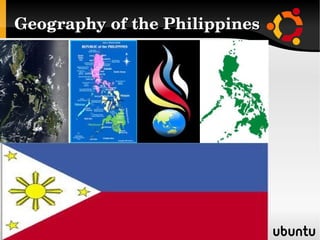
- 3. The Philippine archipelago lies in Southeast Asia in a position that has led to its becoming a cultural crossroads - a place where Malays, Hindus, Arabs, Chinese, Spaniards, Americans, and others had interacted to forge a unique cultural and racial blend. The archipelago numbers some 7,107 islands; and the nation claims an exclusive economic zone (EEZ) of 200 nautical miles (370 km) from its shores. The Philippines occupies an area that stretches for 1,850 kilometers (1,150 mi) from about the fifth to the twentieth parallels north latitude. The total land area is slightly more than 300,000 square kilometers (115,831 sq mi). Only approximately 1,000 of its islands are populated, and fewer than one- half of these are larger than 2.5 square kilometers (1 sq mi). Eleven islands make up 95 percent of the Philippine landmass, and two of these — Luzon and Mindanao — measure 105,000 square kilometers (40,541 sq mi) and 95,000 square kilometers (36,680 sq mi), respectively. They, together with the cluster of islands in Visayas in between them, represent the three principal regions of the archipelago that are identified by the three stars on the Philippine flag. Topographically, the Philippines is broken up by the sea, which gives it one of the longest coastlines of any nation in the world. Physical setting
- 5. The country's most extensive river systems are the Pulangi River, which flows into the Mindanao River (Rio Grande de Mindanao); the Agusan, in Mindanao which flows north into the Mindanao Sea; the Cagayan in northern Luzon; and the Pampanga, which flows south from east Central Luzon into Manila Bay. Laguna de Bay, east of Manila Bay, is the largest freshwater lake in the Philippines. Several rivers have been harnessed for hydroelectric power. To protect the country's biological resources, the government has taken a first step of preparing a Biodiversity Action Plan to address conservation of threatened species.
- 6. Political geography The Philippines is divided into a hierarchy of local government units (LGUs) with the 80 provinces as the primary unit. Provinces are further subdivided into cities and municipalities, which are in turn composed of barangays. The barangay is the smallest local government unit. The Philippines is divided into 17 regions with all provinces grouped into one of 16 regions for administrative convenience. The National Capital Region however, is divided into four special districts. Most government offices establish regional offices to serve the constituent provinces. The regions themselves do not possess a separate local government, with the exception of the Autonomous Region in Muslim Mindanao.
- 7. Regions Ilocos Region (Region I) Cagayan Valley (Region II) Central Luzon (Region III) CALABARZON (Region IV-A) MIMAROPA (Region IV-B) Bicol Region (Region V) Western Visayas (Region VI) Central Visayas (Region VII) Eastern Visayas (Region VIII) Zamboanga Peninsula (Region IX) Northern Mindanao (Region X) Davao Region (Region XI) Soccsksargen (Region XII) Caraga (Region XIII) Autonomous Region of Muslim Mindanao (ARMM) Cordillera Administrative Region (CAR) National Capital Region (NCR; Metro Manila)
- 8. Provinces Abra Agusan del Norte Agusan del Sur Aklan Albay Antique Apayao Aurora Basilan Bataan Batanes Batangas Benguet Biliran Bohol Bukidnon Bulacan Cagayan Camarines Norte Camarines Sur Camiguin Capiz Catanduanes Cavite Cebu Compostela Valley Cotabato Davao del Norte Davao del Sur Davao Occidental Davao Oriental Dinagat Islands Eastern Samar Guimaras Ifugao Ilocos Norte Ilocos Sur Iloilo Isabela Kalinga La Union Laguna Lanao del Norte Lanao del Sur Leyte Maguindanao Marinduque Masbate Misamis Occidental Misamis Oriental Mountain Province Negros Occidental Negros Oriental Northern Samar Nueva Ecija Nueva Vizcaya Occidental Mindoro Oriental Mindoro Palawan Pampanga Pangasinan Quezon Quirino Rizal Romblon Samar Sarangani Siquijor Sorsogon South Cotabato Southern Leyte Sultan Kudarat Sulu Surigao del Norte Surigao del Sur Tarlac Tawi-Tawi Zambales Zamboanga del Norte Zamboanga del Sur Zamboanga Sibugay
- 9. List of landlocked provinces in the Philippines A landlocked province is one that has no coastline, meaning no access to sea or ocean. There are 16 landlocked provinces in the Philippines: All provinces of Cordillera Administrative Region (CAR): Apayao, Abra, Kalinga, Mountain Province, Ifugao and Benguet Two provinces of Cagayan Valley (Region II): Nueva Vizcaya and Quirino Two provinces of Central Luzon (Region III): Nueva Ecija and Tarlac Four provinces of Mindanao: Bukidnon of Northern Mindanao (Region X) South Cotabato of SOCCSKSARGEN (Region XII) Agusan del Sur of Caraga (Region XIII), and Similarly, Laguna and Rizal Province of CALABARZON (Region IV-A) have coastlines on Laguna de Bay. Since lakes do not allow access to seaborne trade, these provinces are still considered to be landlocked.
- 10. List of island provinces in the Philippines An island province completely surrounded by water, is the opposite of a landlocked one. There are 16 island provinces in the Philippines: One province of Cagayan Valley (Region II): Batanes Three provinces of MIMAROPA (Region IV-B): Marinduque, Romblon, and Palawan Two provinces of Bicol (Region V): Catanduanes and Masbate One province of Western Visayas (Region VI): Guimaras Three provinces of Central Visayas (Region VII): Cebu, Bohol and Siquijor One province of Eastern Visayas (Region VIII): Biliran One province of Northern Mindanao (Region X): Camiguin One province of Caraga (Region XIII): Dinagat Islands Three provinces of Autonomous Region in Muslim Mindanao (ARMM): Basilan, Sulu and Tawi-Tawi
- 12. Subnational quadripoint A quadripoint is a point on the Earth that touches four distinct regions. Such points are often called "four corners", from the corners of the four regions meeting there. Four provinces in Mindanao meet at a point at the summit of Mount Apo: Bukidnon of Northern Mindanao Region, Davao del Norte and Davao del Sur of Davao Region, and Cotabato Provinceof Soccsksargen
- 13. Six The municipalities of Basey and Marabut, Samar Province; and Balangkayan, Llorente, Balangiga and Lawaan, Eastern Samar Province.
- 14. Eight The cities of Ligao, Legazpi and Tabaco, and the municipalities of Guinobatan, Camalig, Daraga, Malilipot, Sto. Domingo, in the province of Albay meet on the crater of Mayon Volcano.
- 15. Extraterritoriality Plaza Rizal in Naga City is claimed by the province of Camarines Sur, its home province. The Plaza belonged to the city (formerly Nueva Caceres) when it was the capital of Ambos Camarines. A new capitol was constructed in Pili when Camarines Sur was created.
- 16. Geographic center The island province of Marinduque prides itself as being the geographic center of the Philippines.[1] The Marinduque governor has stated that their claim to be the Geographical Center of the Philippines has received notice and support from the National Mapping and Resource Information Authority (NAMRIA).[2] The Luzon Datum of 1911 in Marinduque is used as point number one for all map makers in the country.[3] The boundaries of the Philippine archipelago are described in Article III of the Treaty of Paris (1898), as comprising an irregular polygon.[4] A box enclosing that polygon would have corners at 20°N 116°E, 20°N 127°E, 4.75°N 127°E, 4.75°N 116°E. The center of this box would lie at 121.5 E, 12.375 N. That point lies roughly in the center of the Tablas Strait between the islands of Tablas and Mindoro. Republic Act No. 9522, "An Act to Define the Baselines of the Territorial Sea of the Philippines",[5] describes an irregular polygon which fits within a box with its center at 121°44'47.45"E 12°46'6.1252"N, a point also roughly in the center of the Tablas Strait. The CIA Factbook locates the Philippines at 13°N 12°E.[6]
- 17. The extreme points under Philippine control as of 2010 are: Direction Location Coordinates Latitude (N) Longitude (E) North Amianan Island, Batanes 21º7’18.41" 121º56’48.79" East Pusan Point, Davao Oriental[a] 7º17’19.80" 126º36’18.26" South Frances Reef, Tawi-Tawi 4º24’53.84" 119º14’50.71" West Thitu Island[b], Kalayaan, Palawan 11°3’10.19" 114°16’54.66" a Pusan Point is the easternmost incorporated territory of the Philippines, but the Benham Plateau is the easternmost unincorporated territory of the Philippines. b Thitu island is the westernmost of all the Spratly Island features controlled by the Philippines as of December 2009. The center of a box enclosing these points would be located at 12°46’6.13"N, 120°26’36.46"E. That point is located in the Mindoro Strait, about 12 km NNE of Apo Island, in Sablayan, Occidental Mindoro.
- 18. Climate The Philippines has a tropical wet climate dominated by a rainy season and a dry season. The summer monsoon brings heavy rains to most of the archipelago from May to October, whereas the winter monsoon brings cooler and drier air from December to February. Manila and most of the lowland areas are hot and dusty from March to May. Even at this time, however, temperatures rarely rise above 37 °C (98.6 °F). Mean annual sea-level temperatures rarely fall below 27 °C (80.6 °F). Annual rainfall measures as much as 5,000 millimeters (196.9 in) in the mountainous east coast section of the country, but less than 1,000 millimeters (39.4 in) in some of the sheltered valleys. Monsoon rains, although hard and drenching, are not normally associated with high winds and waves. But the Philippines sit astride the typhoon belt, and it suffers an annual onslaught of dangerous storms from July through October. These are especially hazardous for northern and eastern Luzon and the Bicol and Eastern Visayas regions, but Manila gets devastated periodically as well.
- 19. In the last decade, the Philippines has been hit severely by natural disasters. In 2005 alone, Central Luzon was hit by both a drought, which sharply curtailed hydroelectric power, and by a typhoon that flooded practically all of low-lying Manila's streets. Still more damaging was the 1990 earthquake that devastated a wide area in Luzon, including Baguio and other northern areas. The city of Cebu and nearby areas were struck by a typhoon that killed more than a hundred people, sank vessels, destroyed part of the sugar crop, and cut off water and electricity for several days. The Philippines is prone to about 6-9 storms which make landfall each year, on average. The 1991 Mount Pinatubo eruption also damaged much of Central Luzon, the lahar burying towns and farmland, and the ashes affecting global temperatures. Building construction is undertaken with natural disasters in mind. Most rural housing has consisted of nipa huts that are easily damaged but are inexpensive and easy to replace. Most urban buildings are steel and concrete structures designed (not always successfully) to resist both typhoons and earthquakes. Damage is still significant, however, and many people are displaced each year by typhoons, earthquakes, and other natural disasters. In 1987 alone the Department of Social Welfare and Development helped 2.4 million victims of natural disasters.
- 20. Terrain The islands are volcanic in origin, being part of the Pacific Ring of Fire, and are mostly mountainous. The highest point in the country is the peak of Mount Apo in Mindanao, which is 2,954 meters (9,692 ft) above sea level. The second highest point can be found on Luzon at Mount Pulog, a peak 2,842 meters (9,324 ft) above sea level. The Philippine Archipelago is geologically part of the Philippine Mobile Belt located between the Philippine Sea Plate, the South China Sea Basin of the Eurasian Plate, and the Sunda Plate. The Philippine Trench (also called the Mindanao Trench) is a submarine trench 1,320 kilometers (820 mi) in length found directly east of the Philippine Mobile Belt and is the result of a collision of tectonic plates. The Philippine Sea Plate is subducting under the Philippine Mobile Belt at the rate of about 16 centimeters (6.3 in) per year. Its deepest point, the Galathea Depth, has a depth of 10,540 meters (34,580 ft). The Philippine Fault System consists of a series of seismic faults that produce several earthquakes per year, most of which are not felt.
- 21. Many volcanoes in the country are active, the most recent eruption being that of Mount Pinatubo on Luzon in 1991. Mount Mayon is another of the active volcanoes and has the world's most perfectly- shaped cone. Mayon has a violent history of 47 eruptions since 1616 and another violent eruption is currently feared. Taal Volcano, also located on Luzon, is one of the Decade Volcanoes. The islands typically have narrow coastal plains and numerous swift-running streams. Every island has sand beaches, but few open onto spacious lowlands. There are few large plains or navigable rivers. The longest river is the Cagayan River or Rio Grande de Cagayan in northern Luzon measuring 354 kilometers. In Mindanao, the longest river is the Rio Grande de Mindanao or Mindanao River which drains Maguindanao and other parts in western-central Mindanao. Agusan River drains eastern Mindanao. Most of the islands used to be covered by tropical rainforests. However, illegal logging has reduced forest cover to less than 10% of the total land area.
- 23. Luzon
- 24. The Batanes And Babuyan islands[edit] The Batanes and Babuyan Islands are found on the Luzon Strait north of the Philippines facing Taiwan. It contains the northernmost point of land, the islet of Y'Ami in the Batanes Islands, separated from Taiwan by the Bashi Channel (c.80.4672 kilometers (50.0000 mi) wide). Western Luzon[edit] This region stretches from Mairaira Point in Pagudpud, Ilocos Norte in the north to Cochinos Point in Mariveles, Bataan in the south. The terrain ranges from coastal plains to rugged mountains bordered by the South China Sea in the west and the Cordillera Central and Zambales mountain ranges in the east. Western Luzon is known for its beaches, surf spots and historic towns.
- 25. Cagayan Valley[edit] Main article: Cagayan Valley Cagayan Valley (Lambak ng Cagayan in Filipino; Tana' nak Cagayan in the Ibanag language; Tanap ti Cagayan in the Ilocano language) is a region of the Philippines, also designated as Region II or Region 02. It is composed of five provinces, namely: Batanes with Basco as the capital, Cagayan, Tuguegarao City as the capital, Isabela considered to be the heart of the region with Ilagan City as the capital, Nueva Vizcaya with Bayombong as the capital, and Quirino with Cabarroguis as the capital. It has four cities; Cauayan and Ilagan City in Isabela, its regional center - Tuguegarao City in Cagayan, and its commercial center - Santiago City in Isabela. Most of the region lies in a large valley in northeastern Luzon, between the Cordilleras and the Sierra Madre mountain ranges. The Cagayan River, the country's longest river runs through its center and flows out to Luzon Strait in the north, in the town of Aparri, Cagayan. The Babuyan and Batanes island groups that lie in the Luzon Strait also belong to the region. Cordilleras and Caraballos[edit] Main article: Cordillera Administrative Region The Cordilleras and Caraballos, together with the Sierra Madre Range, form the main mountain system in Northern Luzon. The Cordilleras consists of 2, sometimes 3, mountain ranges that are found in northwestern central Luzon. The first, called Caraballo del Sur, forms the nucleus of the system and has its highest peaks in the border between the provinces of Abra, Ilocos Norte and Cagayan. The next, called Caraballo Occidentalles, is further divided into 2 ranges, the Cordillera Norte and Cordillera Central. They line the central portions of the Cordillera Administrative Region. The Caraballos (Caraballo de Baler) start where the Sierra Madre and the Cordilleras meet. They are found south of Cagayan Valley, northeast of the Central Luzon Plains.
- 26. Sierra Madre range[edit] The Sierra Madre range is the longest mountain range in the Philippines and lies in the Northeastern part of Luzon Island. The range stretches from Quezon Province to Isabela. 80 percent of the mountain range is tropical rainforest, which is diminishing from rampant illegal logging activity. Only 5 percent of the mountain range is unexplored. The Sierra Madre Mountain Range serves as the eastern wall of Luzon Island that protects inhibitants from tropical cyclones usually coming from the Pacific Ocean. These storms happen an average of 26 per year will cause a lot of distress for the people living in the biggest island of the Philippines. Central Luzon plains[edit] The largest plain in the country and produces most of the country's rice supply, earning itself the nickname "Rice Bowl of the Philippines". Its provinces are: Aurora, Bataan, Bulacan, Nueva Ecija, Pampanga, Tarlac, and Zambales. It is an administrative division or region of the Republic of the Philippines, primarily serve to organize the 7 provinces of the vast central plain of the island of Luzon (the largest island), for administrative convenience Manila-Calabarzon plains[edit] This region is where the capital of the Philippines is located. Large rivers from bays and mountain springs traverse the plain. In the Northern part of the region, that is, Manila and Rizal, most of the plain has been converted into cities, and are thus industrialized. The plain harbors the largest inland freshwater lake in Southeast Asia, the Laguna de Bay.
- 27. Mindoro island[edit] Mindoro coastal plains[edit] Mindoro's coastal plains are characterized by rice and corn fields, rivers, beaches, and extensive open space areas. Most of the population is concentrated on the northern and eastern coast of this island where Calapan and Puerto Galera are located. Mindoro highlands[edit] The Mindoro mountain range begins with Mount Halcon and is further divided into 3. The northwest ends at Calavite Point and is a landmark for ships. The east originates from Lake Naujan and the west follows Mindoro Strait. The endangered tamaraw, or Mindoro dwarf buffalo, is located on Mindoro. Palawan[edit] Kalayaan islands (Spratly Islands)[edit] The Kalayaan islands are located to the west of Palawan. "Kalayaan" is a Filipino word meaning "freedom". see Spratly islands Bicol peninsula[edit] This peninsula is connected to mainland Luzon by the isthmus of Tayabas. Provinces occupying Bicol Peninsula are the provinces of Camarines Norte, Camarines Sur, Albay, Sorsogon and the easternmost municipalities of Quezon Province. Visayas[edit] Catbalogan Plains
- 28. Panay-Negros-Cebu area[edit] This section is empty. You can help by adding to it. (January 2011) Mindanao[edit] Zamboanga peninsula[edit] Zamboanga Peninsula has a very mountainous terrain. The chain of mountain ranges in this region is called Zamboanga Cordilleras. The highest mountain in these ranges is Mt. Dapi, which is 2,617 meters (8,586 ft) high. Misamis coastal plains[edit] This section is empty. You can help by adding to it. (January 2011) Bukidnon-Lanao plateaus[edit] The plateaus are located in the north-central portion of Mindanao. They are extensive flatlands around the height of 1,300 meters (4,300 ft) above sea level. Agusan-Surigao-Davao coastal plains[edit] This section is empty. You can help by adding to it. (January 2011) Southern Pacific cordillera[edit] Compostela valley[edit] This section is empty. You can help by adding to it. (January 2011) Sarangani-Cotabato coastal plains[edit] This section is empty. You can help by adding to it. (January 2011)
- 29. Statistics Unless otherwise indicated, the information below is taken from CIA Factbook information for the Philippines.[6] Area[edit] Total: 300,000 square kilometres (115,831 sq mi) Land: 298,170 square kilometres (115,124 sq mi) Water: 1,830 square kilometres (707 sq mi) Coastline[edit] 36,289 kilometres (22,549 mi) Maritime claims[edit] (measured from claimed archipelagic baselines) Continental shelf: to depth of exploitation Exclusive economic zone: 200 nautical miles (370 km) Territorial sea: irregular polygon extending up to 100 nautical miles (190 km; 120 mi) from coastline as defined by 1898 treaty; since late 1970s has also claimed polygonal-shaped area in South China Sea up to 285 nautical miles (528 km; 328 mi) in breadth. Natural resources[edit] Timber, petroleum, nickel, cobalt, silver, gold, salt, copper, silver Land use[edit] Arable land: 19% Permanent crops: 16.67% Other: 64.33% (2005) Irrigated land[edit] 15,500 square kilometers (5,985 sq mi) (2003)
- 30. Natural hazards[edit] The Philippines sit astride typhoon belt and are usually affected by 15 and struck by five to six cyclonic storms per year; landslides; active volcanoes; destructive earthquakes; tsunamis. Environment - current issues[edit] Uncontrolled deforestation in watershed areas; soil erosion; air and water pollution in Manila; increasing pollution of coastal mangrove swamps which are important fish breeding grounds; severe water pollution that caused the death of one of the country's major rivers, though there are ongoing efforts at resuscitation.[7] Also Typhoon Haiyan in November 2013 caused major problems. Environment - international agreements[edit] Party to: Biodiversity, Climate Change, Endangered Species, Hazardous Wastes, Law of the Sea, Marine Dumping, Nuclear Test Ban, Ozone Layer Protection, Tropical Timber 83, Tropical Timber 94, Wetlands, Whaling Signed, but not ratified: Climate Change-Kyoto Protocol, Desertification Largest cities and towns[edit] The following is a list of the most populous cities in the country, with their population according to the 2010 census. Component cities and municipalities of Metro Manila, Metro Cebu and Metro Davao are taken as one to show the extent of urbanization.
- 31. Largest cities or towns of the Philippines Philippines 2010 Census Rank Name Region Pop. Rank Name Region Pop. 1 Quezon City National Capital Region2,761,720 11 Parañaque National Capital Region 588,126 2 Manila National Capital Region1,652,171 12 Dasmariñas CALABARZON 575,817 3 Caloocan National Capital Region1,489,040 13 Valenzuela National Capital Region 575,356 4 Davao City Davao Region 1,449,296 14 Las Piñas National Capital Region 552,573 5 Cebu City Central Visayas866,171 15 General Santos SOCCSKSARGEN 538,086 6 Zamboanga City Zamboanga Peninsula 807,129 16 Makati National Capital Region 529,039 7 Antipolo CALABARZON 677,741 17 Bacoor CALABARZON 520,216 8 Pasig National Capital Region669,773 18 Bacolod Western Visayas511,820 9 Taguig National Capital Region644,473 19 Muntinlupa National Capital Region 459,941 10 Cagayan de Oro Northern Mindanao 602,088 20 San Jose del Monte Central Luzon 454,55
- 32. THANK YOU FOR WATCHING!!! PREPARE BY : JAZER WAYNE W. CANA