The 8 physical regions of north america
•Als PPTX, PDF herunterladen•
12 gefällt mir•29,115 views


Empfohlen
Weitere ähnliche Inhalte
Was ist angesagt?
Was ist angesagt? (20)
Ähnlich wie The 8 physical regions of north america
Ähnlich wie The 8 physical regions of north america (20)
The 8 physical regions of north america
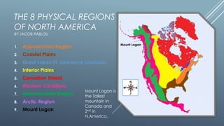
- 1. THE 8 PHYSICAL REGIONS OF NORTH AMERICA BY JACOB RABLOU Mount Logan 1. Appalachian Region 2. Coastal Plains 3. Great Lakes-St. Lawrence Lowlands 4. Interior Plains 5. Canadian Shield 6. Western Cordillera 7. Intermountain Region 8. Arctic Region 9. Mount Logan Mount Logan is the Tallest mountain in Canada and 2nd in N.America.
- 2. APPALACHIAN REGION: A region consisting of the Appalachian Mountains; a range formed 480 million years ago. A range that once stood as tall as the Rockies and Swiss Alps. But has now been reduced to hills thanks to Erosion. 530,947 Sq KM
- 3. Mountainous, many mountain ranges, Old Mountain ranges ≠ 300,000,000 years old. This makes them low as mountain ranges go, because erosion has reduced their once sharp, ragged peaks into rolling mountains and hills. This region is not entirely mountainous, it also contains fertile plateaus and river valleys. Rivers provide great transportation in the Appalachian Region. These valleys can be great sources of coal, oil and gas as they are typically sedimentary rock (compacted, aged sand stones). So these resources are easy to extract as they require less mining since the rock has been stripped away because of erosion, also because of the rock itself being Sedimentary. TOPOGRAPHY
- 4. The climate is affected by two ocean currents. The Labrador Current brings down cold arctic water and causes freezing winters during the Northern part of the region. Secondly the Gulf Stream brings warm air from the Caribbean. The meeting of these two currents provides an ideal breeding ground for fish by encouraging the growth of plankton (that the fish eat). CLIMATE
- 5. Originally the Appalachian region was heavily forested with mixed coniferous (evergreens-trees and shrubs bearing cones) and deciduous (trees that shed their leaves annually) trees. These could survive in the poor and unproductive mountain soil and flourish on the mountain plateaus and in the river valleys where the soil was very fertile. VEGETATION
- 6. Back in the day it was mining, forestry, agriculture, chemical industries, and heavy industry. But as of recent times the economy has diversified. Poverty has decreases significantly. In 1965 1/3 people living there was in poverty, now only 16 % are in poverty compared to the once 33.33 %. The poverty has decreased by 50 %. ECONOMIC ACTIVITY
- 7. The largest concerns of the Appalachian region are Mountain-top removal coal mining, de-forestation, and air pollution. The goals are to restore the forests deemed the most “scenic area of America”. Air pollution has begun to affect plant growth because of the mountains’ elevation and acid rain. Lastly the mountain tops are being destroyed for coal mining and the goal is to stop the mining almost entirely. ENVIRONMENTAL CONCERNS
- 8. Coastal Plains COASTAL PLAINS: A coastal plain is an area of flat, lowlying land adjacent to a seacoast.
- 9. Coastal Plains have an average elevation of less than 200 meters above sea level. Surface can be gently rolling but for the most part flat. More than half of the coastal plains are less than 30 meters above sea level. Coastal Plains contain many Swamps and Marshes. Sinking land has allowed the lower parts of rivers to be flooded by the sea making it able to navigate many miles inland. For example the Hudson river can be navigated as far inland as Albany. Another important feature of the Gulf Coastal Plain is the Mississippi Delta where the Mississippi River empties in the gulf creating a wide plain of fertile land. TOPOGRAPHY
- 10. The climate in the Coastal Plains is that of great variety. In the North it is cold and snowy winters and hot, humid summers. The Southern parts have more of a sub-tropical climate, with mild to warm winters. The only downside to that is that they are more prone to Hurricanes. Hurricane season is between late summer and early winter. CLIMATE
- 11. The soils of Coastal Plains are usually quite sandy. The natural vegetation adapted to this sandy soil, and in some places (Mexico) lush jungles have formed. The original vegetation however was pine forests. VEGETATION
- 12. The Gulf Coast is a major center of economic activity. The marshlands along the Louisiana and Texas coasts provide breeding grounds and nurseries for ocean life that drive the fishing and shrimping industries. The Port of South Louisiana (Metropolitan New Orleans in Laplace) and the Port of Houston are two of the ten busiest ports in the world by cargo volume. The discovery of oil and gas deposits along the coast and offshore, combined with easy access to shipping have made the Gulf Coast the heart of the U.S. petrochemical industry. The coast contains nearly 4,000 oil platforms. The region features other important industries including aerospace, biomedical research, agriculture and especially tourism. ECONOMIC ACTIVITY
- 13. The greatest concern or the Coastal Plains is simply preserving them. The plains are a place of great population and internationally traffic. The oceans and extremely fragile and bio diverse lands: coastal prairies, tidal and freshwater marshes, pine savannas, river corridors, upland longleaf pine forests, pitcher plant bogs, swamps, and many other habitats, all interacting and all essential to our environment. The goals are to educate the public and ignorant landowners of the preciousness of this land and its significance. But most importantly to preserve it. ENVIRONMENTAL CONCERNS
- 14. GREAT LAKES-ST. LAWRENCE LOWLANDS: The Smallest Geographical Location that is bordered by some of the largest.
- 15. The great lakes section of this region is a rolling landscape, created mainly by glaciation (the process in which glaciers carve out valleys. Flat plains are broken apart by hills and deep valleys eroded out by rivers. The St.-Lawrence part consists of flat plains on ether side of the St.-Lawrence River which gradually rise into the Appalachians and Canadian Shield. TOPOGRAPHY
- 16. Humid Continental Climate It is humid because of the presence of the Great Lakes. The Great Lakes tend to cool the temperature during summer and they warm the winters by storing heat. Winters vary from cool to cold and summers from warm to hot. CLIMATE
- 17. Originally this extremely fertile land was treed. The Great Lakes portion had Canada’s largest broad-leafed forests, because its soil and climate conditions were ideal for maple, hickory, beech, and black walnut trees. Elsewhere in this region he vegetation was mixed forest of both deciduous and Coniferous trees such as maple, birch, oak, beech, ash as well as spruce, fir, pine and cedar. VEGETATION
- 18. Although though the St. Lawrence Lowlands is the smallest landform region in Canada, it has a very dense population and contains most of the population of Quebec. The Lowlands are abundant with agriculture, commerce, recreation locations, and transportation centres. The St. Lawrence Lowlands is the most heavily industrialized landform in Canada. It contains most of the country's manufacturing industries. It is 70% farm county/agriculture It is arguably the most significant landmass in Canada. ECONOMIC ACTIVITY
- 19. This is the smallest region in North America, but more importantly Canada. It houses over half of Canada’s population which leads us to the problem. Pollution. In the air, soil, and water. This is what place is what is called “The golden horseshoe of manufacturing”, and for good reason. It holds the most population, cars and companies than anywhere in Canada. The concern is that the Air will become worse (Which it is), the Great Lakes will be polluted, and the air will become toxic due to the raw amount of people and lastly the soil will become infertile because of waste from pollution and industries. ENVIRONMENTAL CONCERN
- 20. The Interior Plains is a vast physiographic region that spreads across the Laurentian Craton of central North America. INTERIOR PLAINS
- 21. In the US the Interior plains are divided into the Central Lowland and the Great Plains The Northern boundary is made up of the Great Lakes, Canadian Shield, and the St.-Lawrence River. Great Plains: 1200m above sea level Central Lowland: 600m above sea level The Plains are gently rolling, gradually sloping down from West to East. Northwards of the plains they continue to the Arctic Ocean . TOPOGRAPHY
- 22. Continental Climate (affected by its location in the heart of the continent) Far from the oceans therefore, a climate of extremes. Long, hot summers and long cold winters. Little precipitation. Farther North the Winters are colder and longer, and the summers are cooler and shorter. Northern portion has an arctic climate, with extremely long, cold winters and short cool summers. CLIMATE
- 23. West of the Mississippi in the Great Plains grasses once grew as tall as a person. The Natural vegetation of the Canadian Prairies was also grassland. Trees only grew in the river valleys. In the Northern parts of the interior plains, boreal forest grows and begins fading out into Tundra as you travel north towards the Arctic ocean. VEGETATION
- 24. The Interior Plains has a couple of major economic activities such as , agriculture, mining. Agriculture is split into 2 parts; livestock and vegetable. The livestock grown in the Interior Plains are: pigs, cattle, and poultry. Vegetables grown in the Interior Plains are: barley, oats, wheat, flax, mustard, canola, potatoes, corn and sugar beets ECONOMIC ACTIVITY
- 25. The most significant problem of the Interior plains is run off. The run off is caused by two main things. Pesticides seeping into groundwater, rivers etc. Also old farm vehicles being driven and the wastes they leak. Also lumber harvesting and the use of landfills. ENVIRONMENTAL CONCERNS
- 26. The largest of all regions, 2 billion years old, it is the geographic foundation of Canada itself covering more than half its surface area. CANADIAN SHIELD Canadian Shield
- 27. During the Ice age glaciers removed most of the soil. Leaving a barren rock surface in many places. Debris left by glaciers dammed up rivers or forced them to change direction creating a chaotic pattern of lakes, rivers and swamps. Average Elevation: 100 meters above sea level in the North and 500 meters above sea level in the South. Center of shield is much lower than the outer proportion therefore the areas around Hudson and James bay are Clay filled lowlands. Because of this most rivers flow into these bays. TOPOGRAPHY
- 28. Due to its vast size, the climate around the Canadian Shield varies greatly from end to end. Generally however, the farther North you travel the colder and longer winters become and the shorter and cooler summers become. CLIMATE
- 29. Boreal forests envelop the Canadian shield for the most part. Forests containing pine, spruce, fir, and many other evergreens as they are suited to the sandy soil. Also some deciduous trees inhabit the shield, such as poplar and white birch. These trees however are smaller and weaker so they are not used for lumber, but rather pulp and paper. North, above the tree line however nothing grows, the growing season is too short, there is too little precipitation and there is permafrost. VEGETATION
- 30. The largest industry in the Canadian Shield is mining as it is the richest region in terms of minerals. Some of the minerals mined there are nickel, gold, silver, zinc and copper. The largest, and most well known mining towns is Sudbury, Ontario. Sudbury is an exception to the normal process of forming minerals in the Shield since there is significant evidence that the Sudbury Basin is an ancient meteorite impact crater. Very good soil so lots of trees so logging is a large industry. ECONOMIC ACTIVITY
- 31. The largest Environmental Concern of the Canadian shield is Acid rain. It is caused significantly here because of the massive population. Acid rain affects granite bedrock the worse because it spreads out the rain and gives it more area to ruin. It also affects marine life, water itself, out buildings, and the air we breathe! The only solution to this is to limit the use of gas fueled vehicles and coal-powered electrical plants . ENVIRONMENTAL CONCERNS
- 32. Our home, it is essentially range after range of mountain ranges separated by Plateaus and Valleys with the Rockies being the most easterly range and the Coastal Chain (Volcanic mountains) being the closest to the sea. WESTERN CORDILLERA
- 33. The western cordillera is composed of new mountain ranges not yet ruined by erosion. They are more than twice as high as the Appalachian mountains. The Cordillera is made up of multiple mountain ranges, the largest being the Rocky Mountain Range which forms the continental divide. All rivers east of the Rockies flow east, finding their outlets in the Gulf of Mexico, Arctic ocean or the Hudson and James bay area. West of the Rockies they drain into the Pacific. TOPOGRAPHY
- 34. The wests coast of the cordillera has a maritime climate. Although it varies from west to North, the west coast has a mild moist climate. In fact some parts are amongst the wettest regions on Earth. Moderated by the Ocean, the winters are usually above freezing and the summers are cooler than in the interior. Valleys are warmer than mountain slopes and windward slopes are wetter than leeward slopes due to the clouds needing to drop their precipitation before crossing the mountains. (Rain Shadow effect.) CLIMATE
- 35. The vegetation of the western cordillera varies greatly from one side of a mountain to another. One the moist, windward slopes, evergreens such as Douglas Fir, Western Hemlock, and Western Red Cedar thrive and become enormous with some reaching as high as 30 storey office buildings. Higher up the trees are smaller and at the very top of the mountains the trees stop entirely or the vegetation becomes similar to that of the tundra. On the other drier side of the mountain, grasses and cacti grow in the valleys and farther south the evergreens no longer grow. VEGETATION
- 36. A strong economy indicates the popularity of a certain region, and it consists of different industries such as Fisheries, Forestry, Agriculture, Petroleum products and Mining, and great varieties of recreational activities. Nonetheless, nothing would be available without the Cordillera's irregular and unique topography formed by plate collision millions of years ago. Anyhow, with a land this vast, weather this mild and richness in natural resources, what an amazing place this is that we call home. ECONOMIC ACTIVITY
- 37. Logging and oil exploration have been responsible for accelerated slope erosion, both from the operations themselves and from the access roads built to reach them. Erosion has stripped away the often thin soil cover and caused serious silting of streams. Trace quantities of harmful metals have been released into streams and groundwater from mining operations. Reservoir operations have disrupted fisheries by altering the temperature and flow patterns of streams and by disrupting riparian (streamside) vegetation communities. Wildlife habitat has been lost through the development of lands for agriculture and livestock grazing. ENVIRONMENTAL CONCERNS
- 38. The only deserts in North America, the Intermountain Region lies between The Rockies, Cascade Mountains, Coastal Mountains, and Sierra Nevada. It is a thinly populated area of high plateaus and isolated mountains. INTERMOUNTAIN REGION
- 39. In many places, the streams and rivers never reach the ocean. Instead the flow into brackish (Somewhat salty) lakes. Such as the Great Salt Lake in Utah or they disappear into the desert sinks. In some areas however the rivers do reach the ocean and in some portions there are some areas that can be productive with irrigation. In other places cattle-ranching is possible. Overall very dry (It is a desert) so minimal precipitation and flat sandy landscape with mountains in almost all horizons. TOPOGRAPHY
- 40. The climate here is affected by the elevation and location. Winters can be cool and wet, or hot and dry. In the southern parts, winters are short and quite dry In the northern parts the climate is more moderate with moist winters and hot dry summers. So essentially the region is one bug desert consisting of both kinds of desert, the cold and warm desert. The cold desert will receive more precipitation in the form of snow and the warm will receive less in the from of rain. CLIMATE
- 41. The vegetation genrally ranges between sparse grassland to plants that can survive in semi-desert or desert conditions. The higher areas are covered in thin pine forest. The valleys however are typically covered by sand with cacti and some typical desert vegetation, i.e. shrubs, tumbleweeds, cacti and reeds by river banks. VEGETATION
- 42. The Intermountain Region has begun to grow a diverse economy. It now contains real estate, tourism (Very large one), health services, and lastly construction. ECONOMIC ACTIVITY
- 43. A significant concern is endangered species, 11 of which are birds. For example the Condor which is still bordering extinction even due to extensive help from the government and conservation agencies. Due to the fry air and arid landscape forest fires are becoming a growing problem. ENVIRONMENTAL CONCERNS
- 44. The Arctic Region, a region of extremes, a combination of lowlands, mountains and tundra. ARCTIC REGION
- 45. Much of this region near the ocean is flat. The mountains of the far North were formed by folding and are presently covered by glaciers. TOPOGRAPHY
- 46. The Arctic climate is very severe due to it being so far from the equator, therefore it receives less sunlight. Summer is very short and not very warm. Also because it receives very little precipitation, it is actually a desert. CLIMATE
- 47. The Arctic has only a very small list of life forms that subside in itself. Trees cannot grow on the Tundra because the climate is too cold and dry and only a small amount of thawing occurs during summer. Small shrubs, mosses, and lichens are the only things that can grow here. They cling to the ground, soaking up the small amount warmth and moisture available. VEGETATION
- 48. At this point the only economical objective happening in the Arctic region is the search for resources. A 2008 United States Geological Survey estimates that areas north of the Arctic Circle have 90 billion barrels of undiscovered, technically recoverable oil. 44 billion barrels of natural gas liquids in 25 geologically defined areas thought to have potential for petroleum. This represents 13% of the undiscovered oil in the world. ECONOMIC ACTIVITY
- 49. Although the Arctic is remote and lacks dense populations, it is under threat from environmental stresses largely originating in distant regions. Three main issues regarding the Arctic environment are climate change, changes in biological diversity, and the use of toxic substances. The effects of these changes are becoming increasingly evident in the North: the Arctic appears to be a harbinger of environmental change. ENVIRONMENTAL CONCERNS
- 50. Mount Logan is the highest mountain in Canada and the second-highest peak in North America, after Mount McKinley. The mountain was named after Sir William Edmond Logan, a Canadian geologist and founder of the Geological Survey of Canada (GSC). Mount Logan is located within Kluane National Park and Reserve in southwestern Yukon and is the source of the Hubbard and Logan Glaciers. Logan has the largest base circumference of any non-volcanic mountain on Earth with the massif containing eleven peaks. Elevation: 5,959 Meters Due to active tectonic uplifting, Mount Logan is still rising in height MOUNT LOGAN Mount Logan
- 51. Appalachian Region: Topography of the Appalachian Region! . 2009. Photograph. http://tiffanie-mango.blogspot.caWeb. 16 Feb 2014. <http://tiffaniemango.blogspot.ca/2009/03/topography-of-appalachian-region.html>. Putting the Heat on Nature. 2014. Photograph. wwww.nature.orgWeb. 16 Feb 2014. <http://www.nature.org/ourinitiatives/regions/northamerica/unitedstates/pennsylvania/explore/putting-the-heat-on-nature.xml>. "Appalachian Mountains." www.wikipedia.org. N.p.. Web. 16 Feb 2014. <http://en.wikipedia.org/wiki/Appalachian_Mountains>. "The Appalachian Region." n. page. Web. 18 Feb. 2014. <http://www.arc.gov/appalachian_region/TheAppalachianRegion.asp>. Coastal Plains: Hal , Pierce. Visualization of hurricane Floyd . 2011. Photograph. http://pmm.nasa.govWeb. 16 Feb 2014. <http://pmm.nasa.gov/node/225>. Gary, Reese. Coastal Plain Marsh. N.d. Photograph. n.p. Web. 16 Feb 2014. <http://mnfi.anr.msu.edu/communities/community.cfm?id=10670>. "Coastal Plain Conservancy ." n. page. Web. 18 Feb. 2014. <http://www.wiser.org/organization/view/c4de7845c4e40ed291730d3fdbe88dd0>. J. Holloway, . Open water in post-Katrina marsh, Louisiana . N.d. Photograph. http://microbiology.usgs.govWeb. 18 Feb 2014. <http://microbiology.usgs.gov/image_gallery_katrina_marsh.html>. St. Lawrence Lowlands: "Polution." http://partner.galileo.org. N.p., n.d. Web. 18 Feb 2014. <http://partner.galileo.org/schools/gibson/45_fp/geography/issue/st_lawrence_i/st_lawrencei_1.htm>. I nterior Plains: Interior Plains. N.d. Photograph. www.infogr.amWeb. 17 Feb 2014. <http://infogr.am/Interior-Plains-5?src=web>. "What environmental issues effect the interior plains of Canada?." n. page. Web. 18 Feb. 2014. <http://environmental-protections.info/environmental-issues/whatenvironmental-issues-effect-the-interior-plains-of-canada/>. CITATIONS
- 52. Western Cordillera: Ecology: Nature and the Canadian Shield. N.d. Photograph. http://science4teens.wordpress.comWeb. 17 Feb 2014. <http://science4teens.wordpress.com/ecology-life-supported-by-the-canadian-shield/>. "The Western Cordillera Region of Western Canada." . N.p., 14 Feb 2011. Web. 18 Feb 2014. <http://voices.yahoo.com/the-western-cordillera-region-western-canada-7813884.html>. Section 1: Climate change in Canada. 2008. Photograph. http://www.statcan.gc.caWeb. 17 Feb 2014. <http://www.statcan.gc.ca/pub/16-201-x/2007000/10542-eng.htm>. Canadian Shield: "Acid rain in the Canadian Shield ." . http://partner.galileo.org , n.d. Web. 18 Feb 2014. <http://partner.galileo.org/schools/gibson/4-5_fp/geography/issue/canadianshield_i/canadianshieldi_2.htm>. Intermountain Region: Piñon-Juniper Woodlands. N.d. Photograph. http://www.fs.fed.usWeb. 17 Feb 2014. <http://www.fs.fed.us/rm/reno/research/ecosystems/pinyon-juniper/>. Osoyoos. N.d. Photograph. http://en.wikipedia.orgWeb. 17 Feb 2014. <http://en.wikipedia.org/wiki/Osoyoos>. "The Intermountain MPOs ." (2008): n. page. Web. 18 Feb. 2014. <http://www.azmag.gov/archive/intermountainWeb/aboutUs.html>. The Arctic: Arctic Ice Melt. 2011. Photograph. http://www.huffingtonpost.caWeb. 17 Feb 2014. <http://www.huffingtonpost.ca/2013/08/01/arctic-ice-melt-artic-ecosystems_n_3690664.html>. Plants of the Arctic and Antarctic. N.d. Photograph. http://beyondpenguins.ehe.osu.eduWeb. 17 Feb 2014. <http://beyondpenguins.ehe.osu.edu/issue/polar-plants/plants-of-the-arctic-and-antarctic>. Williams, Tim. "The Arctic: Environmental Issues." (2008): n. page. Web. 18 Feb. 2014. <http://www.parl.gc.ca/content/lop/researchpublications/prb0804-e.htm>. Mount Logan: "Mount Logan." n. page. Web. 17 Feb. 2014. <http://en.wikipedia.org/wiki/Mount_Logan>. CITATIONS
- 53. THANKS AND SORRY FOR THE SIZE OF THE CITATIONS