Wildfire Adapted Community Plan
•
1 gefällt mir•129 views

A wildfire adapted community is defined by the United States Forest Service as "a knowledgeable and engaged community in which the awareness and actions of residents regarding infrastructure, buildings, landscaping, and the surrounding ecosystem lessens the need for extensive protection actions and enables the community to safely accept wildfire as a part of the surrounding landscape." The National Wildfire Coordinating Group definition, which was developed approved by the Wildland Urban Interface Mitigation Committee, is "A human community consisting of informed and prepared citizens collaboratively planning and taking action to safely coexist with wildland fire."

Empfohlen
Weitere ähnliche Inhalte
Was ist angesagt?
Was ist angesagt? (20)
Ähnlich wie Wildfire Adapted Community Plan
Ähnlich wie Wildfire Adapted Community Plan (20)
Mehr von Paul Schumann
Mehr von Paul Schumann (20)
Kürzlich hochgeladen
Kürzlich hochgeladen (20)
Wildfire Adapted Community Plan
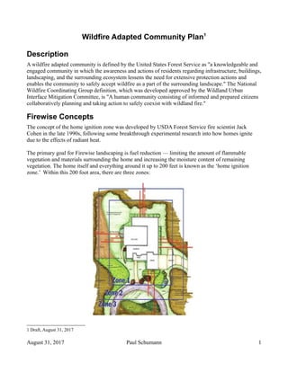
- 1. Wildfire Adapted Community Plan1 Description A wildfire adapted community is defined by the United States Forest Service as "a knowledgeable and engaged community in which the awareness and actions of residents regarding infrastructure, buildings, landscaping, and the surrounding ecosystem lessens the need for extensive protection actions and enables the community to safely accept wildfire as a part of the surrounding landscape." The National Wildfire Coordinating Group definition, which was developed approved by the Wildland Urban Interface Mitigation Committee, is "A human community consisting of informed and prepared citizens collaboratively planning and taking action to safely coexist with wildland fire." Firewise Concepts The concept of the home ignition zone was developed by USDA Forest Service fire scientist Jack Cohen in the late 1990s, following some breakthrough experimental research into how homes ignite due to the effects of radiant heat. The primary goal for Firewise landscaping is fuel reduction — limiting the amount of flammable vegetation and materials surrounding the home and increasing the moisture content of remaining vegetation. The home itself and everything around it up to 200 feet is known as the ‘home ignition zone.’ Within this 200 foot area, there are three zones: 1 Draft, August 31, 2017 August 31, 2017 Paul Schumann 1
- 2. Zone 1 encircles the structure and all its attachments (wooden decks, fences, and boardwalks) for at least 30 feet on all sides. Note: the 30-foot number comes from the very minimum distance, on flat ground, that a wood wall can be separated from the radiant heat of large flames without igniting. Zone 2 is 30 to 100 feet from the home, and plants in this zone should be low-growing, well irrigated and less flammable. Zone 3 is 100 to 200 feet from the home and this area should be thinned, although less space is required than in Zone 2. NOTE: Because of other factors such as topography, the recommended distances to mitigate for radiant heat exposure actually extend between 100 to 200 feet from the home – on a site- specific basis. Homes that are more than 200 feet from the wild land are less susceptible to radiant heat, provided nearby homes do not ignite, but still susceptible to fire danger from embers and low ground fires. All the research around home destruction and home survival in wildfires point to embers and small flames as the main way that the majority of homes ignite in wildfires. For that reason, NFPA recommends methods to prepare homes to withstand ember attack and minimize the likelihood of flames or surface fire touching the home or any attachments (fences, decks, porches) as the first place for homeowners to start working to prepare their properties. Most homes, an estimated 90%, are destroyed from embers. Depending on fire intensity, wind speed and the size of burning materials, embers can travel more than a mile away from the fire. These embers can become lodged in something easily ignited on, in or near the house, eventually starting a small fire which can grow and destroy the home. Proper attention to these vulnerable, easily-ignited areas of the home helps to decrease the home’s risk to being destroyed by wildfire. Inspection As the city has stated that they will no longer conduct firewise inspections of homes, Lost Creek has to provide it's own inspections. Lost Creek has 318 homes directly in the WUI, adjacent to the wildland, or 25% of it's 1,250 homes. The WUI is 6.5 miles long. Of the 318 homes, about 50% have enough land between their house and the wildland to implement the firewise recommendations for ignition zone 1. About 38% can implement zones 1 and 2. And, 12% can implement all three zones. The goals of the Lost Creek Wildfire Adapted Community Plan are to: • Identify a group of 5 volunteers to form an inspection committee • Send them to be trained as inspectors • Inspect 100% of the homes in the WUI, adjacent to the wildland, that only have enough land to implement zone 1 • Inspect 50% of all the homes having the ability to implement zones 1 and 2. August 31, 2017 Paul Schumann 2
- 3. • Inspect any others on demand. Home Owner Defense The homeowner is responsible for the preparation and maintenance of his or her home and land from radiant heat and embers from wildfires, and reducing the risk of fire transmission to neighbors. The more land the homeowner has, the more ignition zones they have control over, the more defensible it is, and the lower the risk of wildfire affecting their homes. The goals of the Lost Creek Wildfire Adapted Community Plan are to: • Provide education in firewise concepts • Provide information on landscaping and services to help homeowners mitigate wildfire risks • Raise money to help homeowners dispose of cuttings not provided by the city Wild Land Mitigation The wildland adjacent to Lost Creek has three types of owners: • City of Austin • Lost Creek Limited District • Private owners Almost all of the land owned by the city is part of the Barton Creek Wilderness Area, and part of that area is also part of the Travis County Canyon Lands Preserve. It constitutes the largest portion of the WUI with 3.1 miles. The land owned by the Limited District forms about 2.1 miles of the WUI. And, private land makes up about 1.3 miles of the WUI. If a 100 foot strip is is mitigated for a wildfire with a shaded fuel break, almost 80 acres will need to be mitigated. Twice that or 160 acres for a 200 foot strip. Shaded Fuel Break is removing the highly inflammable trees (eastern red cedar, brush, and small dead trees) which when ignited shoot embers skyward that are blown down wind to ignite new sites. Wild fire is cooled down from extremely hazardous to grass fire burning under hardwoods (that are less combustible) which may or may not ignite. Fire fighters fighting a cooler fire are relatively safer and their ability to contain the fire is more manageable. “Fires regularly cost around $50 000 per acre to suppress whereas a shaded fuel break costs $500 to $1,200/acre to create.2 ”3 4 5 Once fuels have been modified within an area, maintenance activities should be planned and implemented on a regular basis to keep the effectiveness of the original treatment. If no maintenance activities occur, the effectiveness of the original treatment will diminish every year, potentially yielding no net effect within 5 years. The necessary maintenance activities will be minimal if implemented on an annual basis. 2 Community Shaded Break Project, Nevada County Resource Conservation District (NV) 3 Santa Clara County reported a cost of $15,000 an acre. (CA) 4 Butte County Fire Safe Commission reported a cost of $4,800 an acre. (CA) 5 The Auburn Journal reported a cost of $4.500 per acre. (CA) August 31, 2017 Paul Schumann 3
- 4. Usin g the basis of $1,200 to $4,800 per acre, the project for a 200 feet wide shaded fuel break would range between $192,000 and $768,000. The goals of the Lost Creek Wildfire Adapted Community Plan would be to: • Refine the cost estimate • Explore and develop multiple sources to fund the project (city, county, state, federal, foundations, individual and corporate contributions) • Obtain bids • Manage the project Emergency Services The goal of the Lost Creek Wildfire Adapted Community Plan is to advocate for improvement in EMS and AFD response times. This might require a new Austin fire station on Loop 360, or an agreement with the Travis County station already on Loop 360. Evacuation Plan With 1,250 dwelling units and over 3,000 citizens, the Lost Creek neighborhood is larger than the City of West Lake Hills. In addition, the stretch of Loop 360 from Westbank to Las Cimas, has three schools (2 elementary and 1 high school), office space approaching 1 million square feet, two other neighborhoods and a shopping center. The evacuation plan for Lost Creek must include coordination with all the other entities in the corridor. Part of the corridor is within the City of West Lake Hills, and Loop 360 is managed by TxDOT. Lost Creek has two primary exits – East and West on Lost Creek Blvd. - and a secondary exit north on Falcon Ledge Drive. Courtyard's Recently completed Evacuation Plan6 focuses on the following areas: • Ready, Set, Go! Program • When to Evacuate • Evacuate or Shelter in Place • If You Become Trapped • Returning Home After a Wildfire • Courtyard Wildfire Emergency Information • People with Disabilities and Medical Conditions • My Personal Wildland Fire Action Plan The goals of the Lost Creek Wildfire Adapted Community Plan are to: • Form a permanent committee for the neighborhood to create an evacuation plan and update it 6 It does not appear to specify evacuation routes or assembly locations external to the Courtyard. It does specify an internal assembly point. August 31, 2017 Paul Schumann 4
- 5. when necessary. • Coordinate the evacuation route determination and emergency information sources with all concerned entities. • Administer education programs for the residents of Lost Creek. Infrastructure The infrastructure goals for the Lost Creek Wildfire Adapted Community Plan are to: • Consider emergency vehicles in any traffic calming plan for Lost Creek Blvd. • Advocate for higher water capacity for fire suppression. The Austin Fire Marshall has advised Lost Creek that we currently have enough water to fight one house and 1/3 house fires, insufficient for a wildfire emergency. Land Development Code Inn addition to all the activities mentioned above, Lost Creek should support two additions to the Austin's Land Development Code: 1. A construction standard for new homes built in the WUI7 . 2. Implementation of the firewise ignition zones model to buffer new homes being built on the WUI. Resources Natural and Built Environment Code Prescription: Analysis, Paul Schumann, April 26, 2016 Lost Creek Wildfire Assessment, Paul Schumann, September 28, 2016 Fire Adapted Austin, Justice Jones Wildfire Evacuation Planning: Austin and Travis County, Justice Jones Courtyard Community Wildfire Evacuation Plan, July 18, 2017 7 Wildlands Urban Interface August 31, 2017 Paul Schumann 5
- 6. Appendix Home Defensibility A Fire Adapted Community A fire adapted community is defined by the United States Forest Service as "a knowledgeable and engaged community in which the awareness and actions of residents regarding infrastructure, buildings, landscaping, and the surrounding ecosystem lessens the need for extensive protection actions and enables the community to safely accept fire as a part of the surrounding landscape." The National Wildfire Coordinating Group definition, which was developed approved by the Wildland Urban Interface Mitigation Committee, is "A human community consisting of informed and prepared citizens collaboratively planning and taking action to safely coexist with wildland fire." August 31, 2017 Paul Schumann 6
- 7. Achieving fire adapted communities is an approach that concentrates on plans and activities that reduce risk before a wildfire occurs. It does not rely on government agencies, through suppression activities, to protect communities after a wildfire starts. While a precise definition may not exist, a fire adapted community has a combination or mixture of similar characteristics: • The community exists within or adjacent to a fire prone ecosystem and has a defined geographic boundary. • Residents possess the knowledge, skills, and willingness to properly prepare their homes before a wildfire threatens, prepare to evacuate, and safely evacuate when necessary. • Local fire suppression forces have the adequate skills, equipment and capacity to manage wildfire. • Residents and the local fire agencies have met and understand the local fire suppression capability and related fire response expectations. • Landowners are aware of fuels threats on their property and have taken action to mitigate the danger. • Structures and landscaping are designed, constructed, retrofitted, and maintained in a manner that is ignition resistant. • A community wildfire protection plan is developed and implemented. • The community has embraced the need for defensible space by creating fuel reduction zones and internal safety zones, where treatments have been properly spaced, sequenced, and maintained over the long term. • Local government has effective land use planning and regulation, including building codes and local ordinances. • Property owners have an understanding of their responsibilities before, during and after a fire. August 31, 2017 Paul Schumann 7
- 8. Wildfire Risk August 31, 2017 Paul Schumann 8 Area Ignition Density Fire Intensity Rate of Spread Fire type Defensibility of Homes Number of Homes Barton Creek 43% 90% 33 – 44 ft/min Canopy 59% 13 Barton Creek North 50% 90% 55 – 165 ft/min Canopy 100% 4 Barton Creek South 14% 88% 33 – 44 ft/min Canopy Some Surface 47% 15 Barton Creek SW 14% 90% 33 – 44 ft/min Canopy 33% 6 Barton Creek West 28% 80% 33 – 44 ft/min Canopy 33% 8 + condos Big Canyon 28% 88% 33 – 44 ft/min Canopy 44% 22 Country Club 28% 88% 55 – 165 ft/min Canopy 100% 21 Cypress Canyon 21% 90% 33 – 44 ft/min Canopy 54% 53 Indian Canyon 71% 90% 33 – 44 ft/min Canopy 50% 34 Marshal Ranch 100% 85% 33 – 44 ft/min Canopy Some Surface 37% 21 Sedgefield Canyon 43% 90% 33 – 44 ft/min Canopy Some Surface 50% 32 Y Canyon 93% 90% 33 – 44 ft/min Canopy Some Surface 45% 66 Y Canyon South 43% 90% 33 – 44 ft/min Canopy 64% 23