
Empfohlen
Weitere ähnliche Inhalte
Was ist angesagt?
Was ist angesagt? (20)
Andere mochten auch
Andere mochten auch (20)
Ähnlich wie Triangulation plain
Ähnlich wie Triangulation plain (14)
Triangulation plain
- 2. Triangulation: to locate yourself on a map by comparing your topographic map to what you are looking at, and identifying terrain features that you are sure you can recognise for real and on the map
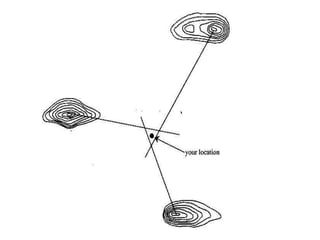
- 3. Position Fixing – Triangulation or Resection 1. Used when you’re unable to fix your position 2. Find 3 prominent features 3. Take a magnetic bearing of the features 4. Convert these to a grid bearing 5. Change to a back bearing 6. Plot all bearings on map 7. Your position is where the back bearings intersect.
- 4. Features Magnetic bearings Grid bearings Back bearings Draw bearings on your map Triangle of Error (GR)
- 6. Features • Identify Three easily recognisable features that you can see in real life and on the map • The further apart the 3 features the better • for each feature, it helps if there is an exact point you can take a bearing off
- 7. Magnetic Bearings • Your bearings must be taken as precisely as possible from each feature • Using an exact point like a cliff edge or mountain peak helps to maintain accuracy
- 8. Grid Bearings • find the Magnetic Variation for your area • Usually subtract this number from your Magnetic Bearings to create Grid Bearings (for each bearing!) • GMAMGS when Mag North is West of True North (like it is for us in SW WA)
- 9. Back Bearings • Create a back bearing by finding the exact opposite direction (in degrees) of you Grid Bearings (do this for each grid bearing)
- 10. Drawing the Back Bearings • As accurately as possible draw a line on your topographical map along the back bearing (for each back bearing) • Make sure you start the line at the point your compass originally aimed at
- 11. Triangle of Error • You should be left with three lines that intersect in a triangle • This is the Triangle of Error and you now know your position is within this triangle! • Give a 6 digit GR for your final answer All images sourced from Google image search and are used for education purposes only