2. 2
to extract relevant information from the large number of
complex datasets available is key to achieving the core aims
of the NRFA. IT systems are required for the storage and
management of data, the integration and visualisation of data,
and the production of a range of detailed statistics.
NRFA data management systems
The range of hydrological regimes across the world, and
the different level of data availability between countries,
means that hydrological systems requirements of NHSs
vary from country to country. However, there are some core
requirements, namely for the handling and processing of time
series of river flows, that are common to all hydrological
archives. Figure 1 shows a schematic representation of NRFA
data processes from acquisition to dissemination. Numerous
commercial packages exist to provide standard functionality
for time series data management, including visualisation,
conversion between intervals and the production of statistics.
Several packages are specifically tailored for hydrological
data, providing additional functionality, e.g. for rating
development and management and flow duration calculations:
WISKI (Kisters, 2010a), TIDEDA (NIWA, 2010), HydroLog
(Isodaq, 2010), HYDATA (CEH, 2010), Hydstra (Kisters,
2010b), etc. These packages meet the principal requirements
for hydrological data management systems, often including
the retrieval of data from telemetry systems for real-
time processes such as flood monitoring. The NRFA has
slightly different requirements, with a need for tools to
summarise, visualise and analyse daily mean flows rather
than converting raw water level data to flows via ratings,
and so has traditionally developed its own bespoke systems.
This approach allows for flexibility in the development of
new aspects of the system, particularly for the production of
additional statistics and the addition of new data validation
and improvement tools. The NRFA systems also allow greater
integration of time series with spatial information than many
existing tools. The systems consist of databases, computer
code for data handling and statistical calculations, software
for visualisation within user interfaces, and external web-
pages for the dissemination of data. An incremental approach
to development is taken, whereby new functionality identified
for addition is built based on common core functionality,
allowing the reuse of standard building blocks of existing
code. The development and maintenance of bespoke
systems requires the retention of specialist skills in software
development and databasing, and so is not an option for
many NHSs. However the basic functionality outlined below
should be of interest to anyone involved in the management
of hydrological archives.
Hydrological data management within the NRFA,
particularly the annual on-take, validation and storage of river
flow data, is undertaken within a set of specific guidelines
and under a Service Level Agreement with the Measuring
Authorities through which data quality and quantity submitted
is monitored. The NRFA systems are integrated with these
guidelines and provide the means for achieving the high
levels of validation required.
Time series datasets
The principal datasets within the NRFA are gauged daily
mean flow series from gauging stations across the U.K. For
several stations, series of estimated naturalised flow series
are also archived. Some longer records include periods of
monthly mean flows where daily data are not available.
Currently the archive constitutes over 50 000 station years
of monthly and daily mean flow data for some 1400 gauging
stations. Monthly peak flows are also archived. Hydrological
context to these river flows, to enable validation and other
NRFA activities, is provided through additional datasets.
These include daily and monthly storage raingauge data
from the UK Met Office, groundwater levels from the British
Geological Survey, reservoir storages, etc. Further derived
time series such as monthly catchment average rainfall and
runoff are either pre-processed and stored, or derived at the
point of use.
Metadata
Additional datasets, which could be described as metadata,
provide information on gauging stations and gauging station
catchments. These generally include anything that could assist
users of the river flow data, within or external to the NRFA,
to understand the data, their accuracy and major influencing
factors. Gauging station information includes grid references,
operator information, gauging station structure, bankfull
flow, sensitivity, etc. Time series metadata, much of which is
automatically derived, includes completeness information and
key time series statistics (mean flow, exceedance percentile
flows, Base Flow Index, etc.). A station description provides
a digested summary of known influences on the flows such
as weed growth, bypassing, major abstractions, discharges
or reservoirs, and aspects of the station’s history, including
significant rating changes, alterations to measurement
Figure 1 Schematic representation of NRFA data validation, analysis and dissemination processes
Regional
River Flow
Data
Regional
River Flow
Data
Regional
River Flow
Data
Data Reception
Store
Data
Submission
and Loading
Data Validation
Main National
Hydrometric
Database
Web-Portal
Manual
Enquiry
Service
SLA
Scores
Data Query
Process Publications
DataProviders
Internal Data
Analysis
HYDROMETRIC MEASURING
AUTHORITIES
NATIONAL HYDROMETRIC INFORMATION SERVICE
NHMP: National
Hydrological
Situation
Monitoring
DATA SENSING AND RECORDING DATA VALIDATION AND ARCHIVAL
DATA SYNTHESIS
AND ANALYSIS
INFORMATION
DISSEMINATION
DISPERSEDHYDROMETRICDATA
NATIONALHYDROMETRICINFORMATION
3. 3
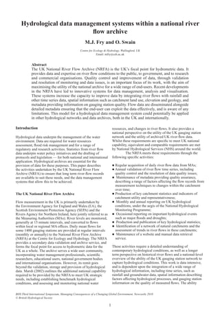
Figure 2 NRFA gauging station summary sheet showing the range of metadata provided to data users
Centre for Ecology and Hydrology, Wallingford, Oxon OX10 8BB, UK.Tel. (01491) 838800. 21st September 2010
Data Retrieval Service
National River Flow Archive
NRFA Gauging Station Information Sheet
Leven at Leven Bridge
Measuring Authority: Environment Agency
Grid Reference: 45 (NZ) 445 122
Station Type: Compound broad-crested weir
Gauged Flows and Rainfall: 1959-2008
NRFA Station Number: 25005
Local Number: 3802
Daily Flow Hydrograph Flow Duration Curve
0.05
0.1
0.2
0.5
1
2
5
10
20
50
100
Jan Feb Mar Apr May Jun Jul Aug Sep Oct Nov Dec
m
3
s
-1
Max. and min. daily mean flows from 1959 to 2008 excluding those for the
featured year (2007; mean flow: 1.98 m
3
s
-1
)
0.1
0.2
0.5
1
2
5
10
20
1 5 10 20 30 40 50 60 70 80 90 95 99
Percentage of time flow exceeded
m
3
s
-1
Jan-Dec Dec-Mar Jun-Sep
Flow Statistics
(Units: m
3
s
-1
unless otherwise stated)
Mean flow
Mean flow (ls
-1
/km
2
)
Mean flow (10
6
m
3
/yr)
Peak flow / date
Highest daily mean / date
Lowest daily mean / date
10 day minimum / end date
60 day minimum / end date
240 day minimum / end date
10% exceedance (Q10)
50% exceedance (Q50)
95% exceedance (Q95)
Mean annual flood
IH Baseflow index
1.88
9.58
59.3
124.6
71.6
0.088
0.106
0.146
0.323
4.119
0.846
0.248
45.4
0.44
2 Nov 2000
2 Nov 1968
4 Sep 1976
9 Sep 1976
9 Sep 1976
6 Jan 1965
Rainfall and Runoff
Rainfall (1959-2008) mm Runoff (1959-2008) mm
Mean Max/Yr Min/Yr Mean Max/Yr Min/Yr
Jan 64 132 1960 13 1989 48 99 2008 7 1989
Feb 50 104 1978 6 1998 36 101 1978 9 1973
Mar 54 159 1999 6 1973 36 142 1979 6 1973
Apr 56 179 2000 10 2007 29 113 2000 5 1997
May 52 151 1979 14 1992 17 76 1979 6 1982
Jun 62 164 2007 13 1960 12 44 2007 3 1960
Jul 62 152 1960 16 1983 10 57 2007 3 1976
Aug 72 155 2004 12 1995 11 51 1978 2 1976
Sep 64 251 1976 14 1997 11 63 1993 2 1990
Oct 66 185 1960 11 1969 20 112 1960 3 1959
Nov 75 181 2000 19 1964 31 157 2000 3 1964
Dec 70 156 1978 21 1988 41 92 1979 6 1964
Year 747 998 2000 448 1964 302 542 2000 94 1989
Station and Catchment Characteristics
Station level
Sensitivity
Structurefull flow
Catchment area
Maximum altitude
FSR slope (S1085)
1961-90 rainfall (SAAR)
FSR stream frequency (STMFRQ)
Urban extent
Flood Attenuation Index
(mOD)
(%)
(km
2
)
(mOD)
(m/km)
(mm)
(junctions/km
2
)
(0-1)
(0-1)
5.2
23.0
70.00
196.3
454
4.17
725
0.0099
0.9977
Station and Catchment Description
Compound broad-crested weir, width 17.4m, with a bypass Crump
profile weir width 4.6m. Theoretical rating (but also gauged to
almost Qmed). Sharp bend and road bridge just u/s of weirs and
large drop below, therefore believed to be modular throughout
range. Suffers from siltation upstream of the weir which may affect
calculated flows. Bypassed only during Nov. 2000 flood (peak flow
may be unreliable). Oct 2005 data removed due to construction of
fish pass. Flows from 04/08/2005 to 06/01/2006 may also be
affected, and were due for investigation in spring 2007. Sensibly
natural regime. Due for replacement with new station at Foxton
Bridge, 6km upstream, commissioned in 2005.
Headwaters drain from the Cleveland Hills. Mixed geology of mostly
Permian/Jurassic age, generally low permeability; 80% superficial
deposits, mainly boulder clay. Mixed agriculture, with some
moorland and forestry in headwaters, minor urban development in
Factors Affecting Runoff
Natural to within 10% at the 95 percentile flow.
Runoff increased by effluent returns.
Summary of Archived Data
Gauged Flows and Rainfall
Key: All
rain-
fall
Some
or no
rain-
fall
All daily, all peaks
All daily, some peaks
All daily, no peaks
Some daily, all peaks
Some daily, some peaks
Some daily, no peaks
No gauged flow data
A
B
C
D
E
F
=
a
b
c
d
e
f
-
Naturalised Flows
Key:
All daily, all monthly
Some daily, all monthly
Some daily, some monthly
Some daily, no monthly
No daily, all monthly
No daily, some monthly
No naturalised flow data
A
B
C
D
E
F
=
0 1 2 3 4 5 6 7 8 9
1950s - - - - - - - - - e
1960s A A A A A A A A A A
1970s A A A A B A A E A A
1980s A A A A A A A A A A
1990s A A A A A A A A A A
2000s A D A A A D A A E
4. 4
structures, or periods with known data quality issues,
considered by the NRFA to be most important for end users.
Catchment information includes statistics on rainfall, land
cover, elevation, hydro-geology, and a range of statistics
obtained from the Flood Estimation Handbook (Bayliss,
1999), and are derived from the spatial datasets described
below. Figure 2 shows a standard NRFA gauging station
information sheet illustrating the range of gauging station
metadata available.
These metadata provide the context for expert
and novice users of hydrological data to gain an initial
understanding of the quality of flow data from a gauging
station, and the maintenance of these metadata are key to the
NRFA’s efforts to maximise the utility of gauging station data.
To this end, selected statistics and metadata are published on
a regular basis within a Hydrometric Register (Marsh and
Hannaford, 2008) and provided to data users.
Spatial datasets
River flows are the result of hydrological processes
distributed across the area of a catchment and can provide
valuable information about those processes. Conversely,
to understand the river flow regime, information about
the catchment is required, particularly aspects of the
catchment important to the hydrological processes. The
statistical catchment metadata described above can assist
an understanding of a catchment’s influence on flows, but
spatially distributed data provide a far more comprehensive
view. The NRFA maintains several core spatial datasets,
specifically, gauging station locations and their digitised
catchment boundaries, and further sets of contextual data
that allow the river flow data to be fully understood. These
additional datasets include land cover (Fuller et al., 2002),
hydrogeology, a digital terrain model (DTM) (Morris and
Flavin, 1990), digital river network, Standard Average Areal
Rainfall (SAAR) (Spackman, 1993), and a range of the FEH
Catchment Descriptor datasets, many of which are indicative
statistics derived from the DTM and Hydrology of Soil Types
(Boorman et al., 1995) datasets.
NRFA databases
Databases within a hydrological archive must provide some
fundamental functionality: security, auditing, and flexibility
of access. To this end, NRFA data are stored in an Oracle
Relational Database Management System, backed-up daily.
The database design provides a simple and transparent
model allowing fast and reliable access via direct query or
through software tools. This model contrasts with those of
many commercial hydrological data management tools,
which tend to use bespoke data formats or very complex
RDBMS structures, and allows application code to be rapidly
developed to utilise the data directly, including libraries
of SQL commands for specific data retrievals, R scripts
for direct statistical analysis of the data, Fortran routines
managed by hydrological modellers, and complex software
tools. This enhances the utility of the river flow data within a
research organisation such as CEH.
Time series data, provided by the Measuring
Authorities, are loaded to temporary tables during the
validation process. Where available, data quality flags and
comments from Measuring Authorities are also loaded to
assist the validation process with information recorded
at the point of measurement concerning issues occurring
with equipment, maintenance of stations, etc. This allows
NRFA staff validating the data to understand data issues
without recourse to MA staff in the first instance. During the
validation process, software tools allow more problematic
queries about specific flow series to be passed to the MA staff
for explanation or resolution. Validated data are loaded from
the temporary tables onto the main database and merged with
the archive. Auditing of changes to data within the database
is enforced, ensuring a minimal audit trail of all changes to
the data. Spatial data are mostly managed within an Oracle
database using the ESRI Spatial Database Engine (ESRI
2010), providing secure storage, multi-user access, and
version management.
Time series data management and analysis
Perhaps the most important aspect of the NRFA data
management systems is the management and analysis of
time series data. The assessment of hydrological conditions
and events and placement of these within the long-term
hydrological context requires the processing and review of
huge ranges of statistics across different intervals. Fast and
accessible tools for the manipulation of time series data
underpin much of the NRFA work in this area, particularly for
publications such as the National Hydrological Monitoring
Programme’s monthly Hydrological Summary (http://www.
ceh.ac.uk/data/nrfa/water_watch.html), and occasional reports
such as those on the 2007 floods (Marsh and Hannaford,
2007) and the 2004 – 2006 drought (Marsh, 2007), and
papers on trends in river flow statistics (e.g. Hannaford and
Marsh, 2008). The code for these tools forms the core of the
NRFA time series systems. Examples of the functionality
provided include conversion between intervals, for example
daily flows to monthly or annual mean, maximum, minimum,
or total flows, calculation of n-day statistics, application of
mathematical operations across multiple time series, as well
as more specific hydrological functions such as base flow
calculation and separation, and flow to runoff conversion. The
code is written in such a way as to allow the output of one
function to form the input of another, meaning that a complex
chain of conversions and operations can be defined by the
user to produce a huge range of statistics without the need for
predefined functions.
A further, and perhaps more important, aspect
of the code design, is the generic approach to time series
handling. The code is based around core concepts of time
series management, such as data type (including flow,
rainfall, etc.), unit (m3
s-1
, mm, etc.), interval (15-minute,
daily, monthly, etc.), statistic (mean, max, min, total, etc.).
This allows new time series datasets to be simply integrated
into the NRFA systems and analysed with the same tools. In
addition, new datasets do not need to conform to a specific
database format or structure, as long as the meaning of these
concepts can be specified in relation to each time series.
Using tools initially only available for river flows and rainfall,
CEH staff can integrate NRFA data with existing databases
of groundwater levels, water quality data, and lake levels, as
well as project specific databases containing model outputs
or other time series data, without the need for restructuring
the data. This integration not only allows the tools to be
applied to new datasets, but enhances the ability to validate
river flows through the provision of more information on
the hydrological context to the flows. The UK Measuring
Authorities can currently produce time series data within a
standardised xml file format which uses the same concepts
and the NRFA can automatically ingest and analyse any
data within this format. NRFA flow data have recently been
integrated with the UK Harmonised Monitoring water quality
database (Simpson, 1978), and national-level assessment of,
for example, chemical mass loads can be rapidly automated.
5. 5
Figure 3 Time Series Plotter showing graph of river flows from the river Nadder (black line) and historic daily extremes for this series (blue and red
banding), together with flows from the river Wylye (red line), rainfall from a raingauge within the catchment (pink bars), and a nearby
groundwater level record (grey line).
Figure 4 Time Series Plotter showing graphs and tables of mean annual flow (red line) and annual 7-day minimum flows (black points) for the Nadder
at Wilton, against total annual catchment annual rainfall (green bars). Table shadings indicate the highest (blue), and lowest (red), 10% of
values.
6. 6
An important recent addition is a set of tools for
infilling missing data. Missing data seriously undermine
the utility of river flow data for purposes such as statistical
analysis and model calibration. For example, many methods
for the extraction of annual maxima or minima will reject
years with missing values, regardless of the likelihood of
the missing periods containing extreme flows. To manually
assess this likelihood when producing statistics is time-
consuming and requires access to other contemporary
information. Appropriate and informed infilling of missing
data, in particular with an aim to maximising the number of
complete years data, can dramatically improve the utility of a
time series for many purposes. Guidelines for the application
of various infilling methods are being developed within the
NRFA (Harvey et al., 2010) and included as tools within the
NRFA systems.
Time series data visualisation
The validation of river flow data is a difficult process to
automate. Basic errors within data can be identified through
automated procedures but the natural variability, and the
subtlety of many hydrological data issues, means that a
visual review of data is an essential aspect of comprehensive
secondary validation. The NRFA validates each new year
of flow data through the comparison of key statistics for the
new period with those for the entire period of record, and a
visual comparison with earlier records at the same location,
with data from nearby locations, and with other hydrological
data such as rainfall. The tool developed for visualisation,
Time Series Plotter (TSP) provides the functionality for this.
Based on the time series management code described above,
TSP allows the integration of time series data and statistics
in a flexible ‘drag-and-drop’ user interface. Figure 3 shows
TSP displaying one year of river flow data against other
nearby river flows, rainfall and groundwater levels. Figure
4 shows TSP displaying graphs of longer-term statistical
information from this station, together with a table of the
same information. The means for rapidly producing such
plots and statistics provides a powerful capability to identify
data issues within individual events and long-term series. The
TSP tool allows NRFA staff validating flow series to rapidly
derive new series, using tools for calculating baseflow, n-day
means, etc. and display these alongside raw data. Time series
generated from infilling methods can be viewed alongside
the series to be infilled and flows from nearby catchments to
assess the validity of the generated series prior to application.
The flexibility and ease with which raw data and derived
series can be produced and integrated allows users to obtain a
full understanding of events.
Metadata, including gauging station quality criteria
and catchment information, can also readily be accessed
through the system, providing further information to enable
decisions to be made regarding the quality of river flow data.
Spatial data visualisation and analysis
Spatial data and spatial information are also heavily used
within NRFA processes. Visually this is important for the
assessment of the spatial variability of aspects such as
elevation, land cover, rainfall within catchments, as well as
other aspects that can affect runoff processes and influence
river flow data. Visualisation is generally performed using
ESRI’s ArcGIS, which allows for the rapid integration and
querying of all of the NRFA spatial datasets available. Spatial
analysis is performed in a number of ways. Individual queries
are run within the GIS software to undertake a specific piece
of analysis. Where analyses are regularly run, or are run for
many locations or catchments, these can be scripted and built
into tools. Several series of complementary tools exist for
performing common exercises such as catchment boundary
definitions, retrieval of catchment statistics, etc. The potential
for executing analyses across thousands of catchments allows
publications such as the UK Hydrometric Register to be
produced, and can provide information to feed into modelling
studies.
A subset of NRFA spatial analysis tools provides
information for the assessment of gauging station networks.
The Catchment Utility Index (CUI) (Laize et al., 2008)
provides an indication of the frequency with which a gauged
catchment in the UK is called into the Flood Estimation
Handbook pooling group for 4 million catchments across
the country. This can provide an independent measure of
the strategic usefulness of gauging stations, though focused
on floods and using one particular, albeit national standard,
method. The CUI tools that produce this index are an
example of the NRFA’s capability to provide an independent
national perspective on the gauging station network. A
second subset of spatial analysis tools provides information
for assessing how well a given gauging station catchment
represents a region as a whole. Laize (2004) describes
the Representative Catchment Index (RCI), which can be
calculated for one or more given catchment descriptors, to
establish ‘representativeness’ or a target region in terms of
combinations of e.g. land use, elevation and geology. The
output of the RCI tools is an independent measure of the
utility of a catchment within a region, or nationally, and can
be used within the strategic management or development of
gauging station networks, for example identifying valuable
additional gauging station locations.
These catchment analysis tools are complex, but
produce simple and readily understandable indices that
provide important national capability within the UK. Adapted
to local requirements and datasets, they would be useful for
NHSs in other countries for the assessment and analysis of
gauging station networks.
Dissemination of river flow data
The dissemination of river flow data forms an important
part of the mandate of the NRFA, and is an important aspect
of the work of hydrological archives in other countries.
Traditionally, this dissemination has taken the form of manual
requests and retrievals. More recently, web-based data access
has become popular and is now the standard means for access
to data. The new NRFA website aims to provide the users of
UK river flow data with not only data, but also the full range
of information required to understand the river flows, their
origins, and the appropriateness for application to a given
purpose. Web-pages for each gauging station provide NRFA
metadata, as described above, allowing users to assess the
quality and extent of the flow record prior to downloading.
For many stations dynamic graphing is available for river
flow time series and flow duration data. Spatial data pages
provide maps and statistics on the range of catchment
descriptors available. Figure 5 shows some example pages
for one station. A map-based portal allows users to find data
by geographic location, or by searches based on gauging
station, catchment or time series metadata, for example
identifying stations with mean flow greater than 50 m3
s-1
,
or where the catchment land cover is >50% forest. The time
series graphing and search pages use extensions of the core
time series management and visualisation code used in the
desktop tools to access dynamically the NRFA databases.
This approach allows new core functionality to be rapidly
7. 7
Figure 5 Examples of gauging station data pages from the NRFA website.
8. 8
delivered via the internet, and ensures publicly available data
is always up-to-date.
Summary and future developments
The UK National River Flow Archive maintains a wide
variety of datasets and hydrological data management
systems in order to undertake its work in maximising the
utility of UK river flow data and providing commentary on
UK hydrological conditions and gauging station network
development. The principal power of these systems lies
in their ability to rapidly integrate a wide variety of time
series datasets within a flexible visual interface and analysis
tools. Furthermore, comprehensive spatial datasets provide
information on gauging station catchments, essential for the
understanding of river flow series, and can feed into tools
for assessing the utility and representativeness of catchments
within wider, e.g. national, networks.
Future plans are to improve metadata management,
particularly providing a greater range of expert comments on
river flow time series and individual events, and to broaden
the suite of spatial data analysis tools to include river network
analysis to allow the linking of river-based sites from
different networks, and furthering the gauging station network
analysis tools.
The systems described above, whilst specific to the
situation and requirements of the UK, can be seen to provide a
model for data management systems that would complement
national hydrological archives around the world. Tools for the
integration of time series datasets, the production of statistics,
and the visualisation of river flow time series alongside other
datasets describing hydrological conditions, are essential for
the detailed secondary validation required for improving the
utility of river flow data. The availability of spatial datasets
such as Digital Terrain Models for catchment definition and
understanding of topographic variability, land cover, geology,
etc. is also essential to adequately understand hydrological
processes influencing river flows. Tools for analysing these
spatial datasets to produce the type of statistics required for
understanding of gauging station networks as a whole could
improve the management of networks in many countries.
References
Bayliss, A.C. 1999. Catchment descriptors. Volume 5 of
the Flood Estimation Handbook. Centre for Ecology,
Wallingford.
Boorman, D.B., Hollis J.M. and Lilly A. 1995. Hydrology
of Soil Types: A Hydrologically Based Classification of
the Soils of the United Kingdom. Institute of Hydrology,
Report No. 126.
CEH. 2010. HYDATA software web page. http://www.ceh.
ac.uk/products/software/CEHSoftware-HYDATA.htm.
Accessed April 2010.
ESRI. 2010. ArcSDE software web page. http://www.esri.
com/software/arcgis/arcsde/index.html. Accessed April
2010.
Fuller, R.M., Smith, G.M., Sanderson, J.M., Hill, R.A.,
and Thomson, A.G. 2002. The UK Land Cover Map 2000:
Construction of a Parcel-Based Vector Map from Satellite
Images. The Cartographic Journal, 39, 15–25.
Harvey, C.L., Dixon, H., and Hannaford, J. 2010. Developing
best practice for infilling daily river flow data. This volume.
Isodaq. 2010. HydroLog software web page. http://www.
isodaq.co.uk/datasystems/hydrolog4. Accessed April 2010.
Kisters. 2010a. WISKI software web page. http://www.
kisters.net/english/html/Nav_NA/RMS/WaterManagement.
html¢er=8FB26FB39796717FC125737F005CE7CB.
Accessed April 2010.
Kisters. 2010b. Hydstra software web page. http://www.
kisters.net/english/html/Nav_NA/RMS/WaterManagement.
html¢er=8835FC6A8D9A9A0DC125732F003F36CC.
Accessed April 2010.
Laize, C.L.R. 2004. Integration of spatial datasets to support
the review of hydrometric networks and the identification
of representative catchment. Hydrol. Earth Syst. Sci., 8,
1103–1117.
Laize, C.L.R., Marsh, T.J., and Morris, D.G. 2008. Catchment
descriptors to optimise hydrometric networks. Proc. Instn.
Civil Engrs, Water Management. 161, 117–125.
Marsh, T.J. 2002. Capitalising on river flow data to meet
changing national needs — a UK perspective. Flow
Measurement and Instrumentation. 13, 291–298.
Marsh T.J. 2007. The 2004-06 drought in southern Britain.
Weather. 62, 191–196.
Marsh, T.J. and Hannaford, J. 2007. The summer 2007 floods
in England and Wales. National Hydrological Monitoring
Programme series. CEH/BGS. 30 pp.
Marsh, T.J. and Hannaford, J. (Eds). 2008. UK Hydrometric
Register. Centre for Ecology and Hydrology/British
Geological Survey. 216 pp.
Morris D.G. and Flavin R.W. 1990. A digital terrain model for
hydrology. Proc. 4th Int.Symp. on Spatial Data Handling,
Zurich, 1, 250–262.
NIWA. 2010. Tideda software package. http://www.niwa.
co.nz/our-services/software/tideda. Accessed April 2010.
Simpson, E.A. 1978. The Harmonization of the Monitoring of
the Quality of Inland Fresh Water. J. Instn Water Engrs Sci.,
32, 45–56.
Spackman, E. 1993 Calculation and mapping of rainfall
average for 1961–1990. Proc. British Hydrological Society
Symp, Salford.