
Empfohlen
Weitere ähnliche Inhalte
Mehr von hanslunow
Rural land usage identification
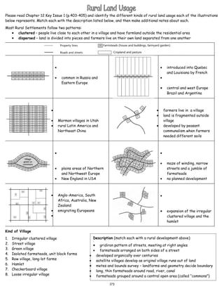
- 1. Please read Chapter 12 Key Issue 1 (p.403-405) and identify the different kinds of rural land usage each of the illustrations below represents. Match each with the description listed below, and then make additional notes about each. Most Rural Settlements follow two patterns: • clustered – people live close to each other in a village and have farmland outside the residential area • dispersed – land is divided into pieces and farmers live on their own land separated from one another • • introduced into Quebec and Louisiana by French • common in Russia and • Eastern Europe • central and west Europe Brazil and Argentina • • farmers live in a village • land is fragmented outside • Mormon villages in Utah village • rural Latin America and • developed by peasant Northeast China communalism when farmers needed different soils • • • maze of winding, narrow • plains areas of Northern streets and a jumble of and Northwest Europe farmsteads • New England in USA • no planned development • Anglo-America, South • Africa, Australia, New Zealand • emigrating Europeans • expansion of the irregular • clustered village and the hamlet Kind of Village 1. Irregular clustered village Description (match each with a rural development above) 2. Street village • gridiron pattern of streets, meeting at right angles 3. Green village • farmsteads arranged on both sides of a street 4. Isolated farmsteads, unit block farms • developed organically over centuries 5. Row village, long-lot farms • satellite villages develop as original village runs out of land 6. Hamlet • metes and bounds survey – landforms and geometry decide boundary 7. Checkerboard village • long, thin farmsteads around road, river, canal 8. Loose irregular village • farmsteads grouped around a central open area (called “commons”) 173