UK, Britain & England
•Als PPT, PDF herunterladen•
0 gefällt mir•229 views

Concepts about UK easily confused

Empfohlen
Weitere ähnliche Inhalte
Andere mochten auch
Andere mochten auch (19)
Kürzlich hochgeladen
Kürzlich hochgeladen (20)
UK, Britain & England
- 1. BRITAIN
- 2. The United Kingdom of Great Britain and Northern Ireland
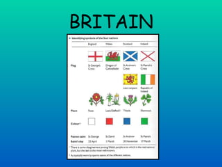
- 4. England England is part of both Great Britain and the United Kingdom. It covers a total area of 130,478 square kilometres - 57 per cent of the whole island, and its capital is London. England is divided into 34 counties. The population of England is 50,762,900 (2006). The overall population density of 376 persons/square kilometre is one of the highest in the world. The national emblem of England is the Rose. Just as the United States is personified as Uncle Sam, so England often appears in caricature as either 'Britannia' , a heroic female figure holding a trident (the symbol of sea power), or as 'John Bull' a goodhumoured, well-fed country gentleman personifying determination and common sense. The patron saint of England is St George, whose feast is celebrated on 23 April (also Shakespeare's birthday).
- 5. Scotland At the beginning of the 6th century, Scotland was ruled by Scottish kings and queens, but was divided between different groups of people. The Picts and Celts, who were the oldest inhabitants, the Scots, who came from Northern Ireland, the Britons , who were driven north by the Anglo-Saxon invaders of England, and the Angles, who originally came from what is now Germany. The Romans had left two centuries earlier. The national symbol of Scotland is the Thistle. The flag of Scotland is called Saltire or St. Andrew's Cross. Scotland is the northern third of the island of Great Britain. Included are about 186 islands. The total land area, including all the islands, is 78,790 square kilometres. The capital of Scotland is Edinburgh and its second largest city. The population of Scotland is 5,116,900 (2005 estimate).The population density is 65persons/square kilometre.
- 6. Wales Wales is approximately 242 kilometres (150 miles) from north to south. About two-thirds of the total population live in the South Wales coastal area, where the three biggest towns are located: Swansea, Cardiff and Newport. The two symbols of Wales are a leek and a daffodil. Dragon of Cadwallader is the national flag of Wales. Wales is united politically, legally, and administratively with England and occupying a broad peninsula on the western side of the island of Great Britain. The total area of Wales is 20,760 square kilometres. Cardiff is the capital, principal seaport, and shipbuilding centre. The population of Wales is 2,958,600 (2005 estimate). The population density was approximately 141 persons per square kilometre.
- 7. Northern Ireland The province of Northern Ireland (sometimes called 'Ulster') consists of six counties: Antrim, Down, Armagh, Tyrone, Fermanagh and Londonderry. The province is surrounded by sea to the north and east, by the Republican countries of Donegal to the west and Cavan and Monaghan to the south. The flag of Northern Ireland is called St. Patrick's Cross. The national emblem of Northern Ireland is a Shamrock. The capital and largest city of Northern Ireland is Belfast (population is 276,459), which is surrounded by heavy industries including shipbuilding and textiles. The total area of Northern Ireland is 14,160 square kilometres. The population of Northern Ireland (2004 estimate) was 1,710,300. Ireland is separated from Great Britain by the Irish Sea. The island is politically divided into two parts: the Republic of Ireland or Eire and Northern Ireland which is part of the United Kingdom. Leprechaun